
DisasterTech
@DisasterTechOrg
A global community of people who develop tools that help humans in crisis situations.
You might like


Interested in using satellite imagery for search and rescue? In the @sentinel_hub webinar @ai6yrham will talk about the use of EO data in SAR, showing his techniques in using sat🛰️ data to locate people. Info and Register for free here ▶️ events.teams.microsoft.com/event/d6739b04… #DisasterTech

Exciting news from the #EarthEngine data team 📢 #Sentinel1 #SAR data latency is reduced from 1.5-2 days to about 12 hours; a significant improvement for crisis response and near-real time Earth monitoring. developers.google.com/earth-engine/d…
We sped up the ingestion of Sentinel-1 assets into Earth Engine. You should now see new images appear in about 12 hours instead of 1.5-2 days.

We built the new processing platform for the @DisastersChart entirely on STAC enabling unified data pipeline for processing satellite imagery from contributing Space Agencies. It reduces the high resolution data analysis latency for rapid response to natural disasters. 3/6


Great example about how satellite imagery can be used to uncover and investigate local issues! 🛰

The oil industry in north east #Syria is increasingly resorting to construction open-air oil wast pits due to lack of proper oil facilities and equipment. Here's a @planetlabs 2016-2021 timelaps of an oil pit south of the Jabisah oil refinery.

Here are some nature-based solutions to address the climate crisis #ClimateAction

The sad start of the 2021 #wildfire season 🔥 Satellite images are an important tool for early detection and fighting of such wildfires, especially in isolated and uninhabited areas!

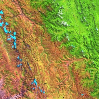
🟠 Several smaller and merging #wildfires🔥 in the #OmskOblast and #TyumenOblast, #Russia🇷🇺 (Lat: 55.53, Lng: 70.80) 17 April 2021 #Copernicus🇪🇺 #Sentinel-2🛰️ Full-size ➡️ flic.kr/p/2kTWNnP #RemoteSensing #OpenData #scicomm #wildfire

Call for contribution: We want to create learning resources for first time users of #EarthObservation data and special interest groups, like journalists or humanitarian organisations. Please help us: 👉 learn.openspacedata.org #EOchat #Journalism #humanitarian #TechForGood

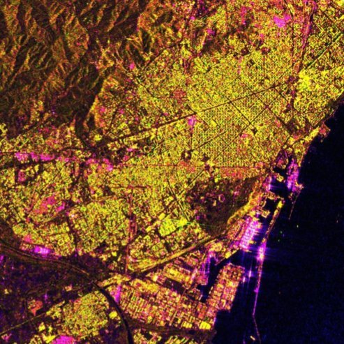
Earth observation can be an important tool in humanitarian work. It can make the extent of #HumanitarianCrisis visible: Take a look at the expansion of #Kutupalong from 2016 until today... It is the world's largest #RefugeeCamp. Nearly 600,000 people are living there.


We add @HazMapper to your Awesome DisasterTech list: github.com/DisasterTechCr… #DisasterTech
github.com
GitHub - DisasterTechCrew/awesome-disastertech: A selection of projects, organisations and useful...
A selection of projects, organisations and useful tools that help humans in crisis situations. - DisasterTechCrew/awesome-disastertech
You should read 'What Happens to Voting When There’s a Natural Disaster' by @linpoonsays from @CityLab -> bloomberg.com/news/articles/…
bloomberg.com
What Happens to Voting When There’s a Natural Disaster
For people displaced by hurricanes and wildfires in the months leading up to the election, voting can be difficult, if not impossible.
Recommendation👇 #DisasterTech

The October #RUSWebinar is now available on our YouTube Channel. 👉 Just visit bit.ly/3jBXRrh 👍 Easy to replay if you missed it !

Free course on Radar applications: dealing with Hazard monitoring and response using SAR. #DisasterTech

⚠️FREE online Course on #SAR Remote Sensing⚠️ Excited to announce that my online course "Synthetic Aperture Radar: Hazards" will launch on @edXOnline on October 5. Register & get more info here: edx.org/course/sar-haz… #GoldenAgeOfSAR @SERVIRGlobal @uafecampus @NASAARSET

The @EuroGeosciences and @EGU_NHESS hosting a virtual meeting on #NaturalHazards in urban environments these days. Topics are #EarthObservation, #UrbanDevelopment, #ClimateChange and #SciComm. Join here 👉🏾 nathazards.org/public.asp?pag…
Great resource on how to build responsible tech with many advices of tech leaders! ✊🏾

👍Our #ResponsibleTechGuide is released!!! 😲161 pages of interviews & advice about getting plugged into the Responsible Tech ecosystem. 👉Aimed at college, grad, and young professions. Released in partnership w/ @NYUAlliance ResponsibleTechGuide.com

Hundreds of volunteers, who otherwise mark 🏠 and 🛣️ on @openstreetmap, added more than 🧼💧🤲 1,100 handwashing stations across the country. news.trust.org/item/202009140… @rinachandran @TRF #Thailand @HOTOSM_ID @mapaction @mapbeks
Great tutorial for preparing for disasters using #OpenSource software by @un_spider 👉 un-spider.org/advisory-suppo… #DisasterTech #GIS #RemoteSensing @qgis


Today is the day - Angry Weather will be on the shelves. I tried to write non-fiction for people like me, who very much prefer a novel. How & why we do science instead of facts, & of course people! greystonebooks.com/products/angry…


United States Trends
- 1. Northern Lights 43.6K posts
- 2. #Aurora 9,156 posts
- 3. #DWTS 52.6K posts
- 4. #RHOSLC 7,012 posts
- 5. Sabonis 6,206 posts
- 6. H-1B 33.4K posts
- 7. AI-driven Web3 1,010 posts
- 8. Justin Edwards 2,419 posts
- 9. #GoAvsGo 1,561 posts
- 10. Gonzaga 2,955 posts
- 11. #MakeOffer 8,694 posts
- 12. Louisville 18K posts
- 13. Creighton 2,275 posts
- 14. Eubanks N/A
- 15. Lowe 12.7K posts
- 16. Jamal Murray N/A
- 17. Schroder N/A
- 18. Andy 60.3K posts
- 19. JT Toppin N/A
- 20. Oweh 2,118 posts


Something went wrong.
Something went wrong.