
IOOS Association
@IOOSAssociation
Advancing @usioosgov and the national coastal, ocean and Great Lakes observation information needs for maritime commerce, public safety, and national security.
You might like


CariCOOS Buoys 7 AM: 📊 LOCATION: WAVE |WIND |CURRENT Ponce: 3.9ft @ 6.3s(SE) |14kt (ENE) |0.29kt (SE) San Juan: 3.3ft @ 11.1s(NE) |8kt (SE) |0.21kt (W) St. John: 3.0ft @ 5.7s(ESE) |15kt (E) |0.43kt (NW) Vieques: 3.3ft @ 5.3s(ENE) |14kt (E) |-- Rincon: 2.3ft @ 12s(N) |-- |--
A study found its regional systems generate $192–$233M/year in value to users (5x the annual investment). cbe.miis.edu/cgi/viewconten… Investing in observing = economic multiplier. #BlueEconomy #OceanData #OceanObserving
🦞 Smart Data = Smarter Lobstering. @neracoos Mariners’ Dashboard gives lobstermen: ✅ Real-time ocean conditions ✅ Temp maps to set traps ✅ Alerts when gear should move Blending centuries of skill with IOOS data: mariners.neracoos.org #LobsterFishing #IOOS #SmartSeafood

Keeping seafood safe & sustainable from dock to dinner. IOOS data helps processors & distributors by tracking: 🔹Coastal hazards 🔹 Water quality for compliance 🔹Seasonal trends for smarter planning Alaska projects: aoos.org/projects/ecosy… #SeafoodSustainability #OceanData

🎣 How deep should we fish for tuna? Data shows us. @nanoos_pnw tools give anglers: ▪️Real-time ocean temps ▪️Daily condition shifts ▪️Confidence to find the bite Because Smart Seafood Starts with Smart Data. 🔗 nvs.nanoos.org/Explorer #TunaFishing #IOOS #NANOOS #OceanData

🦪 From Tide to Table: Oyster Farming in CA. @CeNCOOS gives farmers real-time data to: ▪️Track water quality & ocean acidification ▪️Plan for seasonal shifts ▪️ Align harvest cycles Because sustainability isn’t just practice - it’s science: cencoos.org/oyster-dashboa… #Aquaculture

A strong, sustainable seafood economy depends on more than skill - it depends on data. IOOS helps fishers, farmers & processors: 🔹 Track temps & oxygen 🔹 Detect harmful algal blooms 🔹 Forecast weather & waves Learn more: ioosassociation.org/focus-areas/fi… #SmartDataSmartSeafood


Hurricane #Gabrielle Advisory 34A: Gabrielle Racing Eastward Toward the Azores. Expected to Bring Hurricane Conditions to the Azores Tonight Or Early Friday. hurricanes.gov
8 am EDT - In addition to #Humberto and #Gabrielle, NHC continues to monitor #94L located near the Dominican Republic. This system has a chance of becoming a tropical depression in the vicinity of the central and northwest Bahamas during the next couple of days. Interests in…


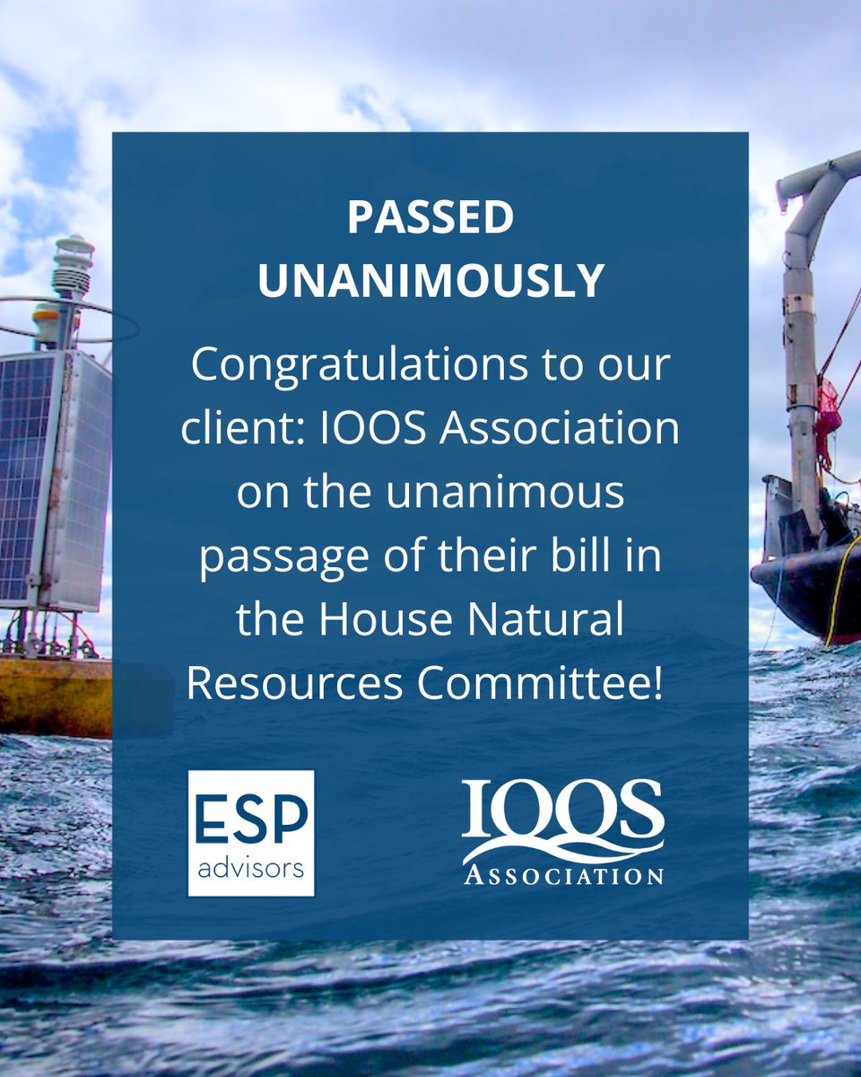
🚨The House Natural Resources Committee just passed the bipartisan IOOS reauthorization bill (H.R. 2294) unanimously! This vital system supports coastal safety & the maritime economy. 🌊📡 Congrats @IOOSAssociation ! @RepMikeEzell @RepBonamici
🚨 New Jersey emergency managers, planners, city leaders—this one's for you. Discover how low-cost, real-time sensors + OceansMap can support smarter coastal decisions. 📅 July 30, 1:30-3 p.m. Eastern 🔗 Register here: us02web.zoom.us/meeting/regist… @IOOSAssociation

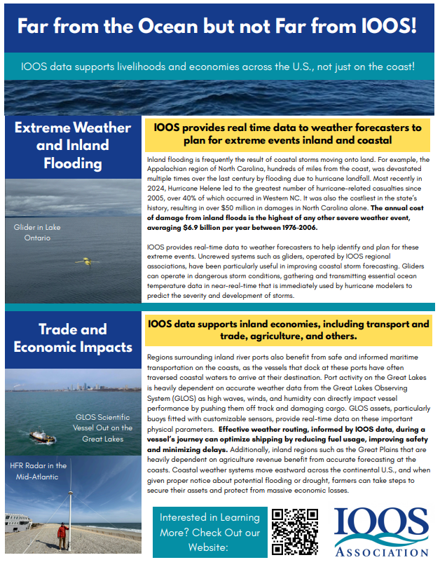
How do @NOAA programs like the Integrated Ocean Observing System (#IOOS) keep people safe - even hundreds of miles from the shore? Download + Share @IOOSAssociation’s newest fact sheet re: inland flooding: ioosassociation.org/wp-content/upl… #ExtremeWeather #OceanData #WeatherPreparedness
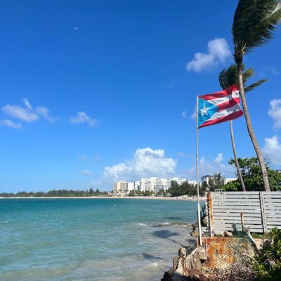
Beach data #onthego with @Caricoos’s Pa’ la Playa mobile app: 🌊 Wave & weather forecasts 💧 Real-time water quality 📍 GPS beach data 🎥 Local insights Download at caricoos.org. #PaLaPlaya #IOOS #BeachSafety #BlueEconomy #PuertoRico #USVI


Here's the weather outlook for July 4th. 🌡️ Hot and humid in the Midwest ⛈️ Wet for much of the Central and Southern U.S. ⚡ Severe storms and heavy rain/flash flooding possible in the Upper Midwest and Plains 💧 Heavy rain possible in the Northern Rockies and Florida


Terrific time at the 2025 @ametsoc conference for broadcast meteorologists in Boise, ID. Gave talks about importance of data/image #attribution, & combating #misinformation. With help of a small foundation grant & @IOOSAssociation we gave copies to many attendees. Thx everyone.


Smart #onthego tools. @caricoos Boating App is a real-time decision support tool delivering high-resolution marine forecasts and observations for #PuertoRico and the #USVI. Download Today! 🔻 iPhone: lnkd.in/evzEDiGp 🔻 Android: lnkd.in/eSswKp4B #OceanData


Maps of high resolution surface currents within the San Francisco Bay - right in your pocket! For maritime operators in the #SanFranciscoBay, precision matters. Delivered by @CeNCOOS. Android: play.google.com/store/apps/det… iPhone: apps.apple.com/us/app/baycurr… #BayCurrents #OceanData

Take a guess, how much does one of the @BackyardBuoys weigh? Drop your guess below 👇 and then watch the story behind this Indigenous-led ocean innovation: youtube.com/watch?v=f4H2b_… #BackyardBuoys #IOOS #OceanData #CommunityScience #BlueEconomy
youtube.com
YouTube
Backyard Buoys Empowers Indigenous Coastal Communities
Knowing what you don’t know can actually make you the smartest (and safest) person on the shore. Watch to learn how to "read" the beach environment — especially the swash zone, where breaking waves and flowing water can hide rip currents and other hazards: oceantoday.noaa.gov/blueiq/blueiq-…


United States Trends
- 1. Northern Lights 37.9K posts
- 2. #DWTS 50.5K posts
- 3. #Aurora 7,760 posts
- 4. Justin Edwards 2,105 posts
- 5. Louisville 17.4K posts
- 6. #RHOSLC 6,430 posts
- 7. #OlandriaxHarpersBazaar 4,802 posts
- 8. Creighton 2,023 posts
- 9. Gonzaga 2,687 posts
- 10. Andy 59.9K posts
- 11. Lowe 12.5K posts
- 12. #GoAvsGo 1,458 posts
- 13. Oweh 2,059 posts
- 14. JT Toppin N/A
- 15. Kentucky 25.2K posts
- 16. H-1B 28.7K posts
- 17. Elaine 36K posts
- 18. Celtics 12.3K posts
- 19. Zags N/A
- 20. Jordan Walsh N/A
You might like
-
 U.S. IOOS Office
@usioosgov -
 Marine Technology Society
@MTSociety -
 MARACOOS
@maracoos -
 SECOORA
@secoora -
 Ocean Observatories
@oceanobserv -
 Ocean News
@oceannews -
 EuroGOOS
@EuroGOOS -
 NOAA's Office of Response and Restoration (OR&R)
@NOAACleanCoasts -
 California Sea Grant
@CASeaGrant -
 N.C. Coastal Reserve
@NCReserve -
 Mid-Atlantic Ocean Data Portal
@PortalMARCO -
 Sea Grant Law Center
@SGLawCenter -
 NOPP
NOPP
@thenopp
Something went wrong.
Something went wrong.