
Laynee Phillips
@LayneeV
TN General Assembly 🇺🇸 Wagner Class of 2016. Seattle➡️Nashville
Bunları beğenebilirsin


Chills. Another great open from @CBSSports. #ArmyNavy

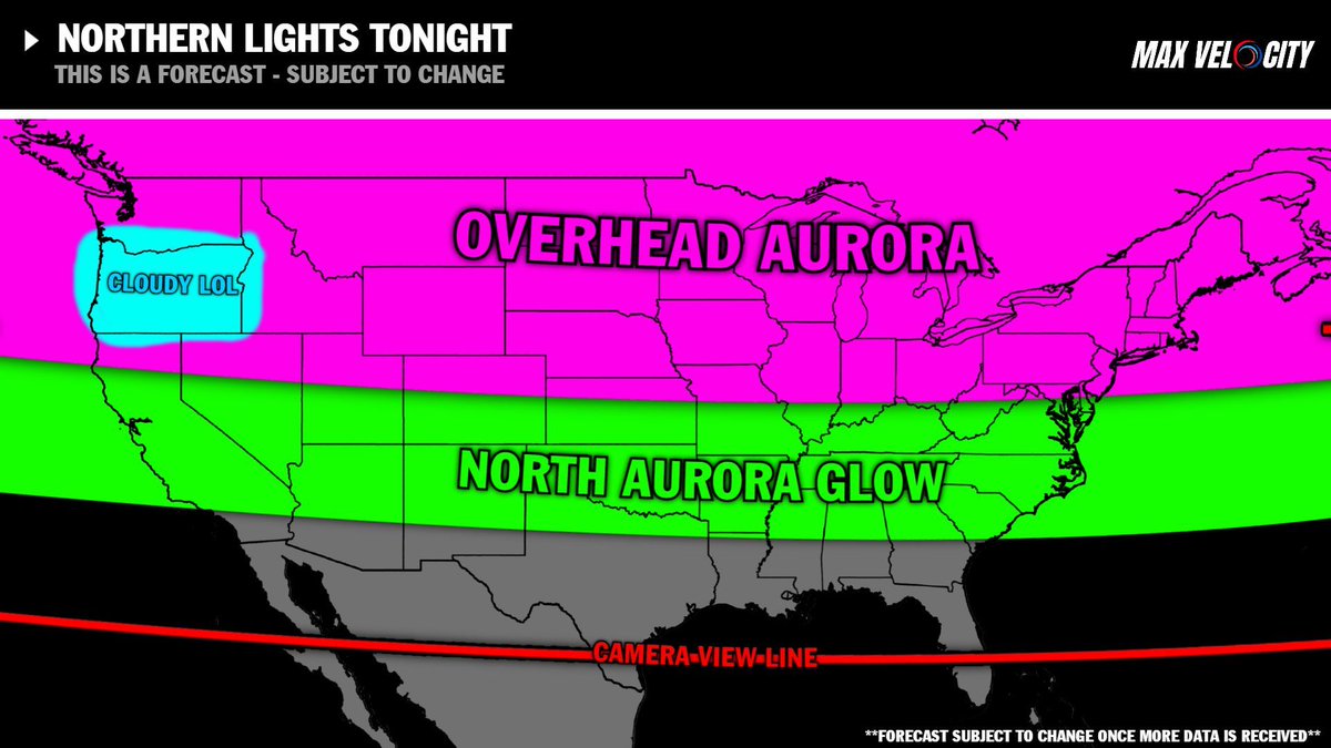
Today's Northern Lights could be BIGGER than last night... Get those cameras ready tonight! We could be in-store for another big show...

Bo's Bash 2025 Recap! What a fun night full of great food and Hamilton County's GOP! Let's do it again in '26!

Charlie was my age. He was a father just like me. He was a Christian just like me. He had no beliefs more extreme than I hold. I can only assume this means they want me dead as well.

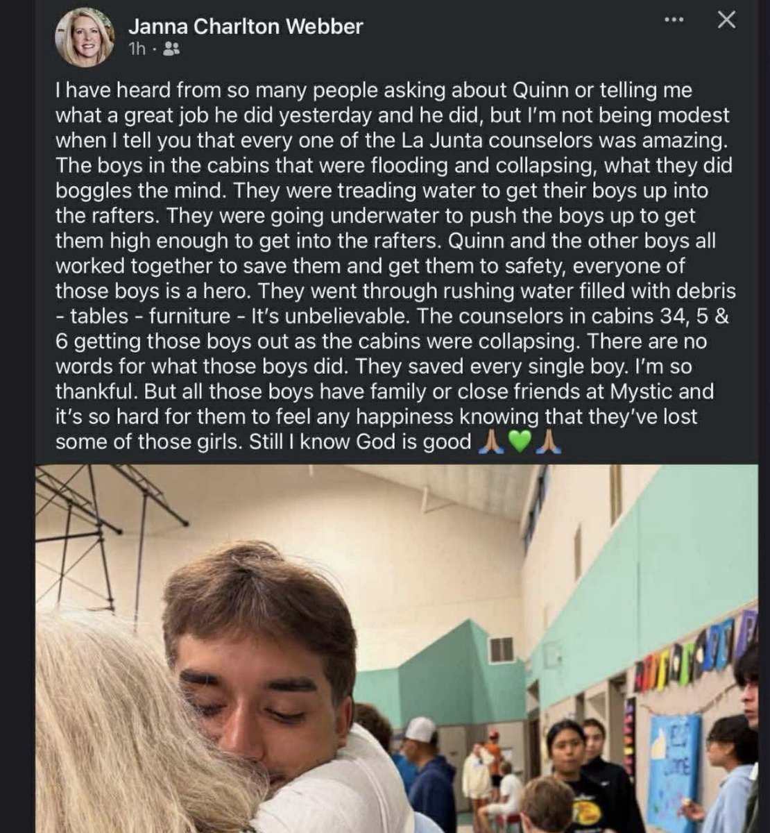
Heroic efforts, plain and simple. These young men will be recognized at the appropriate time. Work continues.
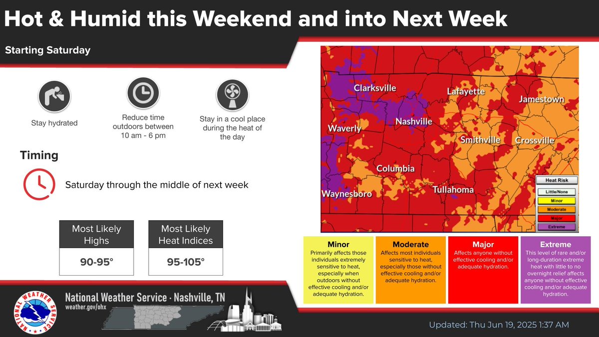
DANGEROUS HEAT DEVELOPING Yeah, I know. "It's summertime, it's supposed to be hot". But seriously, this will be the first big heatwave of the season and it will come on fast. Steamy days, muggy nights, and sudden stress on vulnerable people, pets, and AC systems. Get ready!


Landmark VICTORY for Tennessee at SCOTUS in defense of America’s children! #Skrmetti

A major shakeup could be coming to Metro government after the Tennessee Court of Appeals ruled that a state law slashing the size of Nashville’s Metro Council can move forward. bit.ly/4mSnaHp
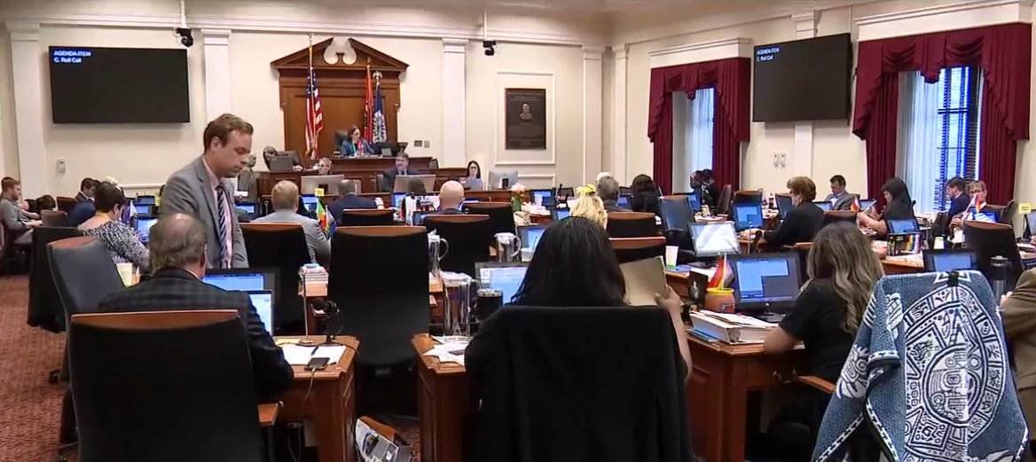


The citizens of TN are well-served by today’s TN Court of Appeals decision on the law sponsored by @WilliamLamberth and me in the 113th TN General Assembly. @hcgoptn @TNGOP wpln.org/post/appeals-c…


House, Senate approve $59B Tennessee budget, removing some Lee priorities. What’s in it? tennessean.com/story/news/pol…

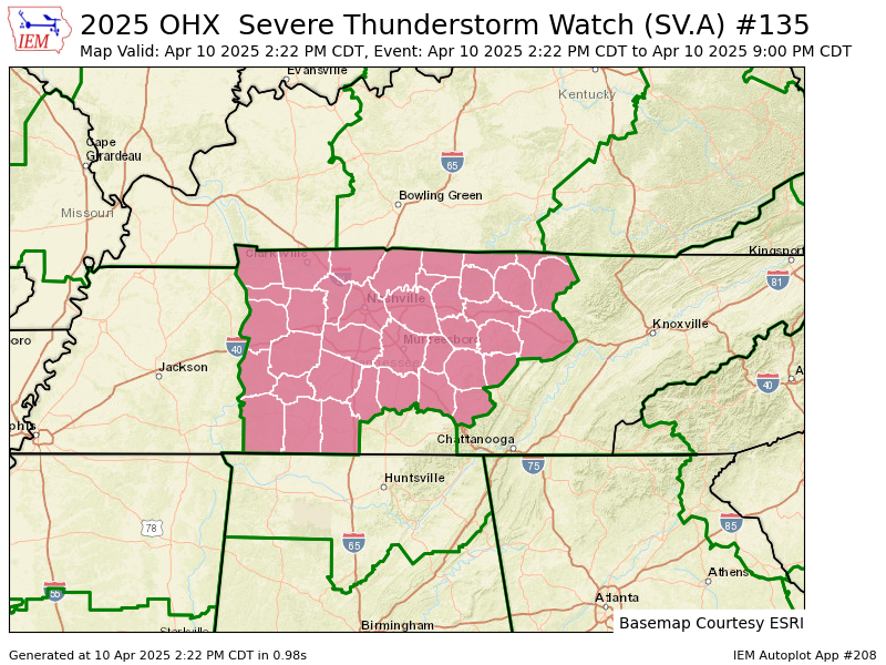
OHX issues Severe Thunderstorm Watch till Apr 10, 9:00 PM CDT mesonet.agron.iastate.edu/vtec/f/2025-O-…

Middle Tennessee has already seen 11 tornadoes in 2025! This is more than our average for the whole year and we could see even more tonight… @WKRN
OHX issues Tornado Warning [tornado: RADAR INDICATED, hail: 1.50 IN] for Davidson, Rutherford, Williamson, Wilson [TN] till 5:00 AM CDT mesonet.agron.iastate.edu/vtec/f/2025-O-…
![NashSevereWx's tweet image. OHX issues Tornado Warning [tornado: RADAR INDICATED, hail: 1.50 IN] for Davidson, Rutherford, Williamson, Wilson [TN] till 5:00 AM CDT mesonet.agron.iastate.edu/vtec/f/2025-O-…](https://pbs.twimg.com/media/GnmdGXOWMAAE6o-.png)
OHX issues Tornado Warning [tornado: RADAR INDICATED, hail: 1.00 IN] for Cheatham, Davidson, Williamson [TN] till 3:00 AM CDT mesonet.agron.iastate.edu/vtec/f/2025-O-…
![NashSevereWx's tweet image. OHX issues Tornado Warning [tornado: RADAR INDICATED, hail: 1.00 IN] for Cheatham, Davidson, Williamson [TN] till 3:00 AM CDT mesonet.agron.iastate.edu/vtec/f/2025-O-…](https://pbs.twimg.com/media/GnmB3MlW4AALsl-.png)
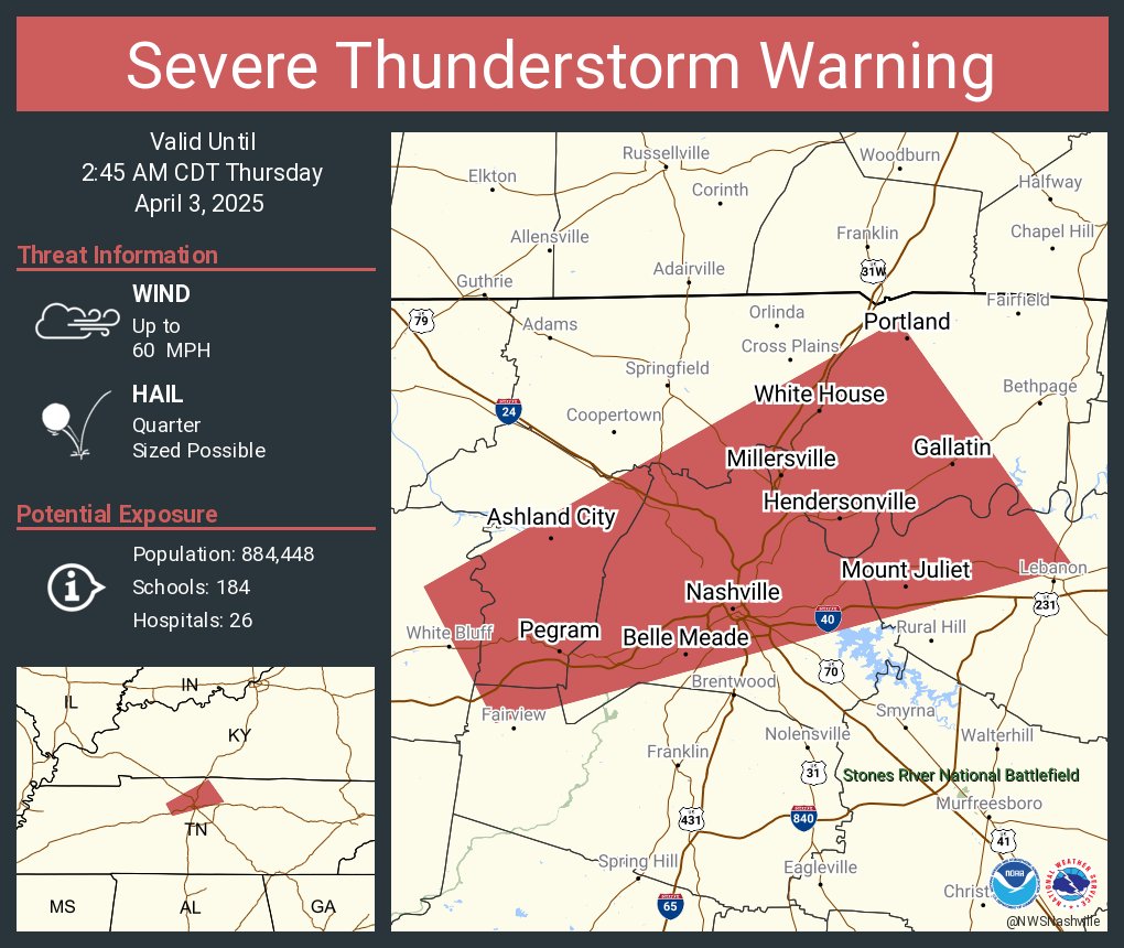
Severe Thunderstorm Warning including Nashville TN, Hendersonville TN and Gallatin TN until 2:45 AM CDT
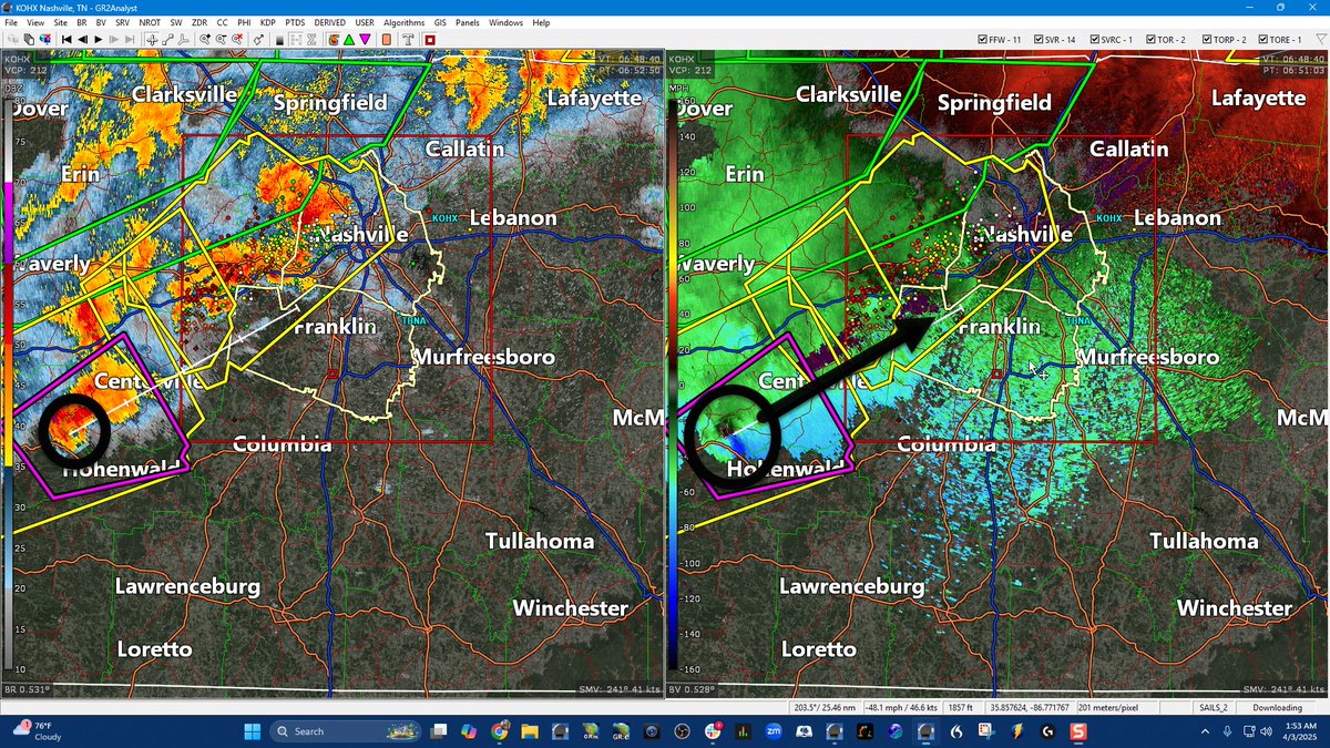
This is an ALARMING LONG TRACKED TORNADO moving in the direction of Western Williamson County and eventually metropolitan Nashville if it holds together. Would get in here in about an hour or so / 155 AM / We are live here youtube.com/watch?v=I2NxaB…
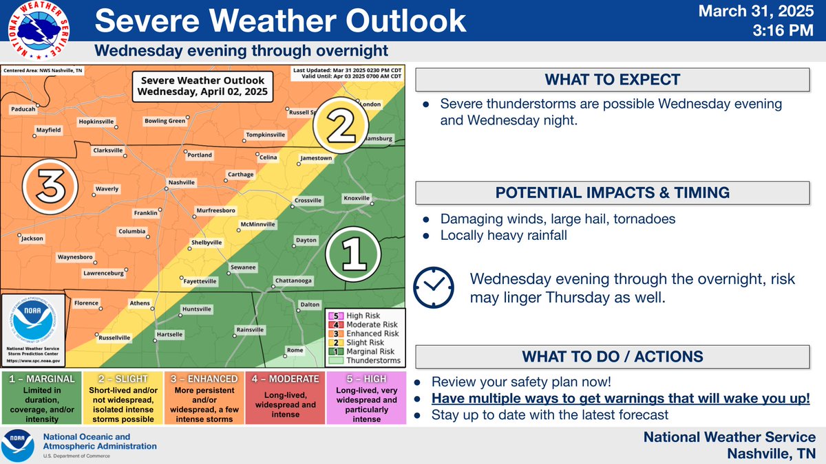
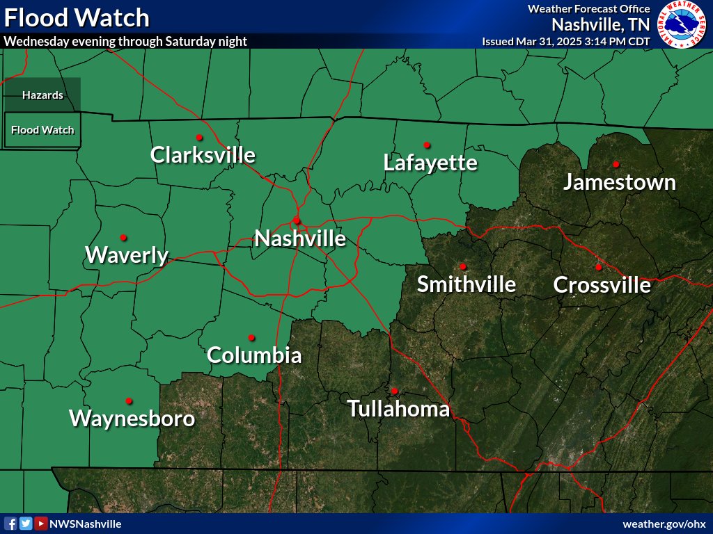
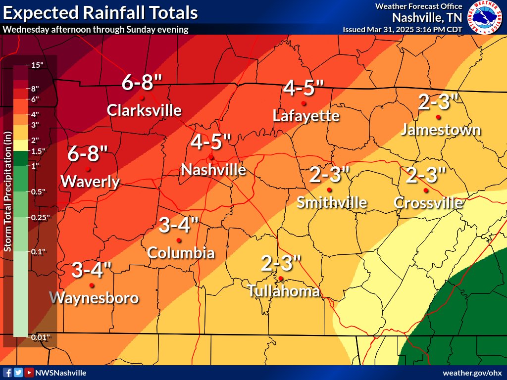
Well, here we go again. We're not getting much of a break between the last severe weather event and the next anticipated event. And we've also issued a Flood Watch for later this week/weekend for some rather large expected rainfall totals affecting parts of Middle Tennessee.

TORNADO OUTBREAK possible this weekend, peaking on Sunday PM into across the heart of Dixie Alley including Memphis to Nashville areas. We define a tornado outbreak as 6 more tornadoes across a region during a 24 hour period. All hazards will likely be possible ahead of this…
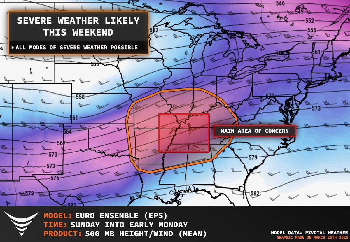

Looking at the setup today across portions of Alabama and Mississippi is well, yikes. Idk how else to describe it. The SPC is explicitly forecasting multiple EF-3 to EF-4+ tornadoes. With an emphasis on that **+** sign which means the conditions today will support EF-5’s. Which…

SPC specifically calling out the chance for EF4+ tornadoes today, wow.


United States Trendler
- 1. #SmackDown N/A
- 2. #DragRace N/A
- 3. Dabo N/A
- 4. Pistons N/A
- 5. #OPLive N/A
- 6. #WWE2K26 N/A
- 7. #loveduringlockup N/A
- 8. Briar N/A
- 9. Attitude Era N/A
- 10. Shinsuke N/A
- 11. Antarctica N/A
- 12. Cade N/A
- 13. Jen Z N/A
- 14. Jalen Green N/A
- 15. Jade Cargill N/A
- 16. FEMA N/A
- 17. Ron Holland N/A
- 18. Jacob Fatu N/A
- 19. Scott Foster N/A
- 20. Ilja N/A
Bunları beğenebilirsin


Something went wrong.
Something went wrong.