Dit vind je misschien leuk


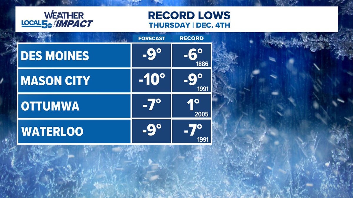
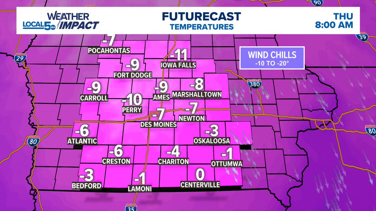
SUB-ZERO THURSDAY MORNING! It'll be our first trip sub-zero and we're not talking by just a little bit... this is a big step down. This is towards record range for many in Iowa. -6° is the record low for Des Moines (1886) Thankfully there isn't a lot of wind. #IAWX #MNWX
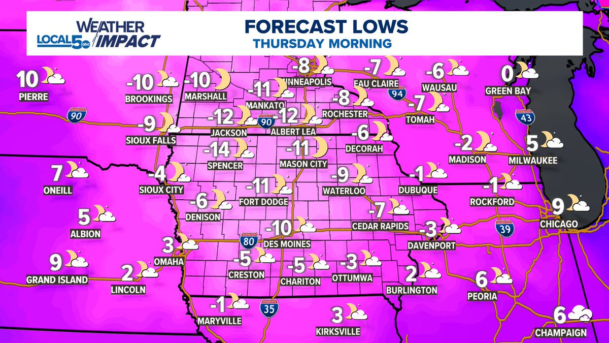
We're on Record Low watch for Thursday morning. Temps drop below zero for the first time this year and much of Iowa is looking at setting some new records. #IAWX #DSM #DesMoines
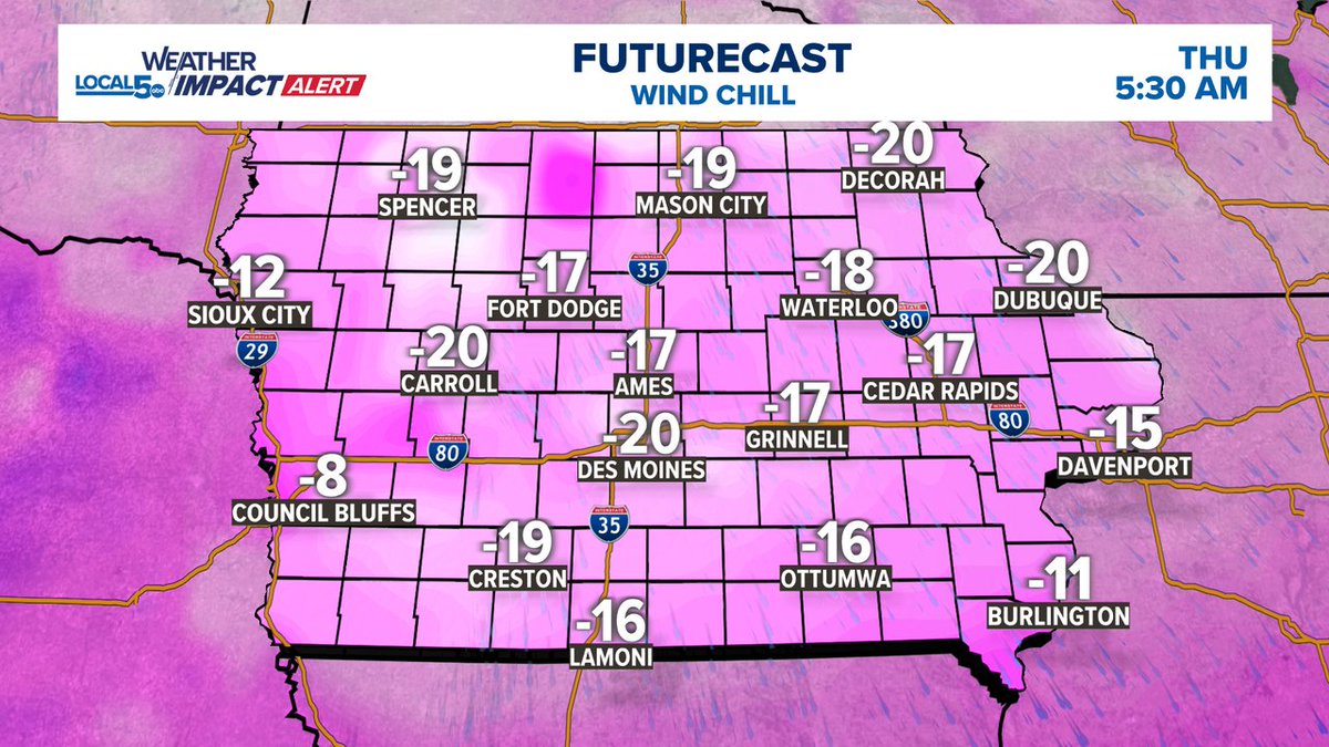
First taste of sub-zero temps and wind chills taking the dive down to -15 to -20° early Thursday morning. Diving into it hard and early this season. #IAWX
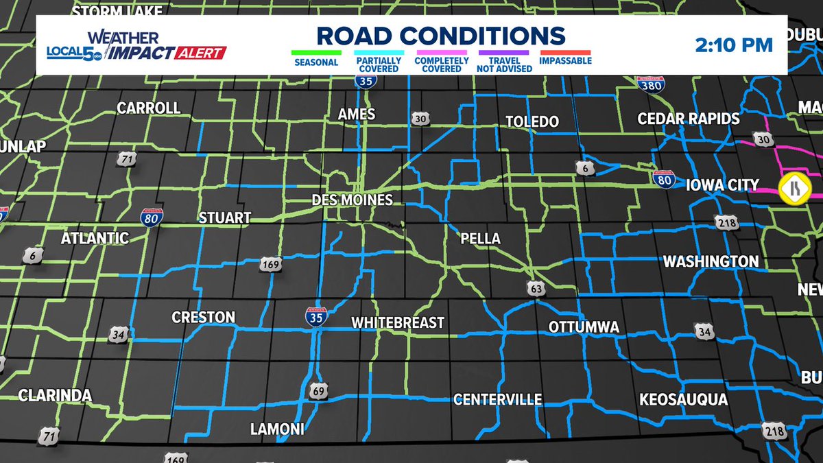
Partially covered roads dot central and southern Iowa. Don't let these spots sneak up and surprise you. Light snow is falling. Take things a little easier out there through the evening drive. #IAWX
A potent cold front dips through on Wednesday. Temps look to take their first trip below zero for Thursday morning. Wind Chills drift towards -10 to -20° too. Hello Winter! #IAWX #WindChill
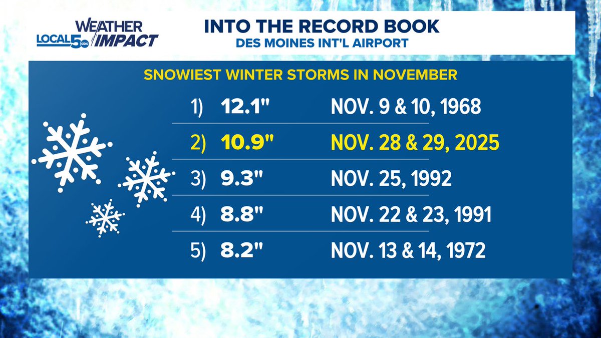
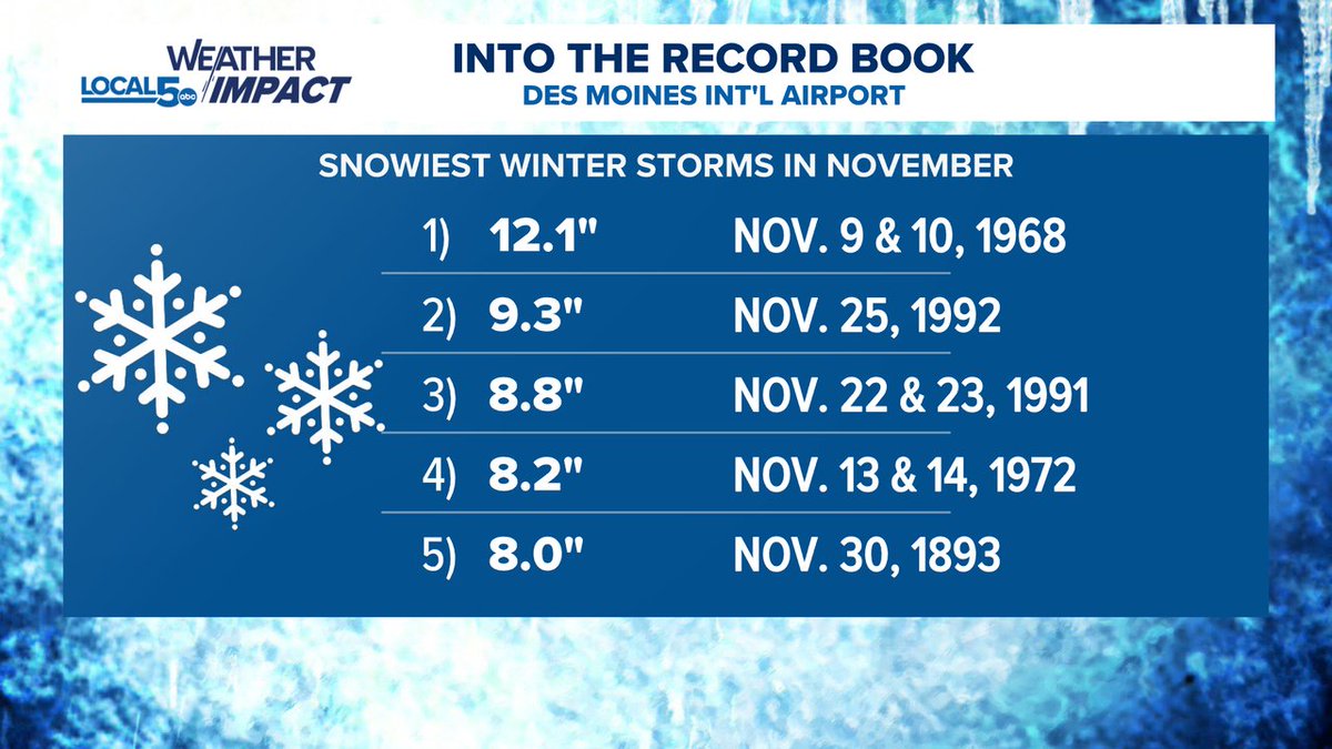
This last winter storm in Des Moines marked the 2nd snowiest storm ever in the month of November. 10.9" fell at Des Moines Int'l on the 28th & 29th. The snowiest was November 9th & 10th in 1968 with 12.1". #IAWX
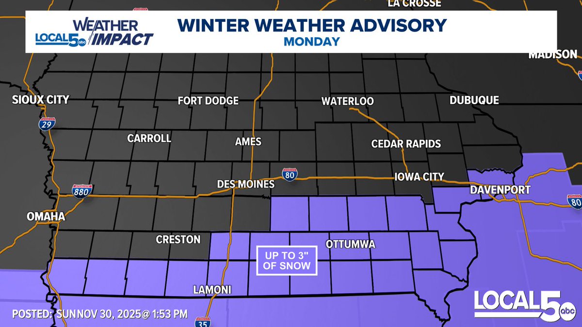
A Winter Weather Advisory is in effect for Monday across southern/southeast Iowa. Up to 3" of snow is expected with slippery travel conditions through the day. Mid-morning to early-evening timeframe for accumulation. #IAWX
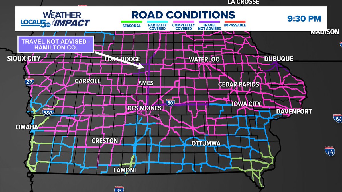
Roads continue to be completely covered by snow and ice across much of Iowa. A few spots are travel not advised with one of those areas being in Hamilton County. Hazardous travel will continue overnight. #IAWX
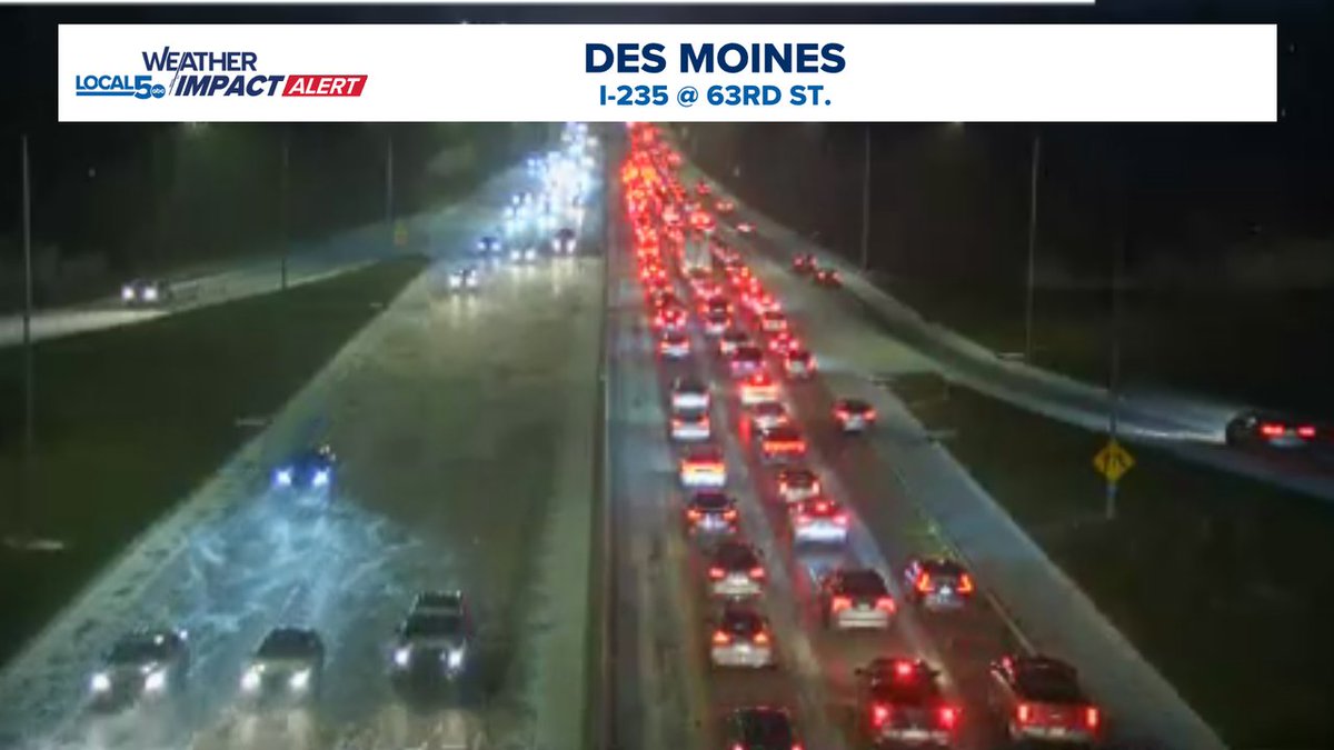
That didn't take long. Traffic is snarled due to an accident on eastbound I235 in Des Moines east of 63rd St. Roads are already becoming slick. They won't be getting any better through the evening. Take care out there. Extremely hazardous driving is ahead tonight. #IAWX #DSM
This winter storm will likely go down as one of the snowiest on record for Des Moines in the month of November. The record is 12.1" which fell on November 9 & 10, 1968. The record book dates back to 1878. #IAWX #DSM
And so it begins. Snow is starting to take over the Des Moines area and the rest of central Iowa. Stay safe as we extend into the weekend. #IAWX #DSM
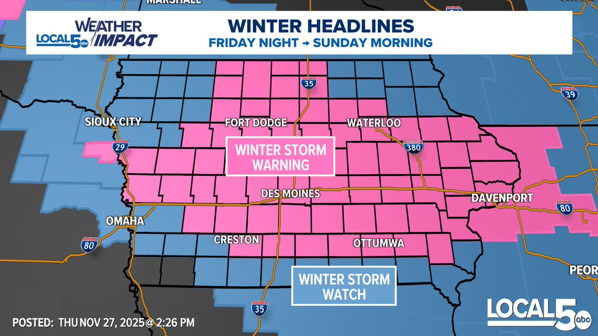
Winter Storm Warning holds over southern MN and almost all of IA. This will be the target zone for heaviest snow amounts. My expectation is for many to rise up towards a foot of snow. Impacts begin Fri. evening and last into early Sun. morning. Travel will be extremely difficult.
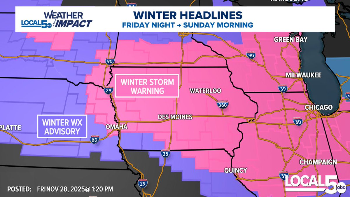
A Winter Storm Warning is now in place for almost all of central Iowa. Winter Storm Watch on the southern edge will continue. Expect high end snow totals Friday night through early Sunday morning. This map will continue to be fluid over the next 24 hours. #IAWX #DSM
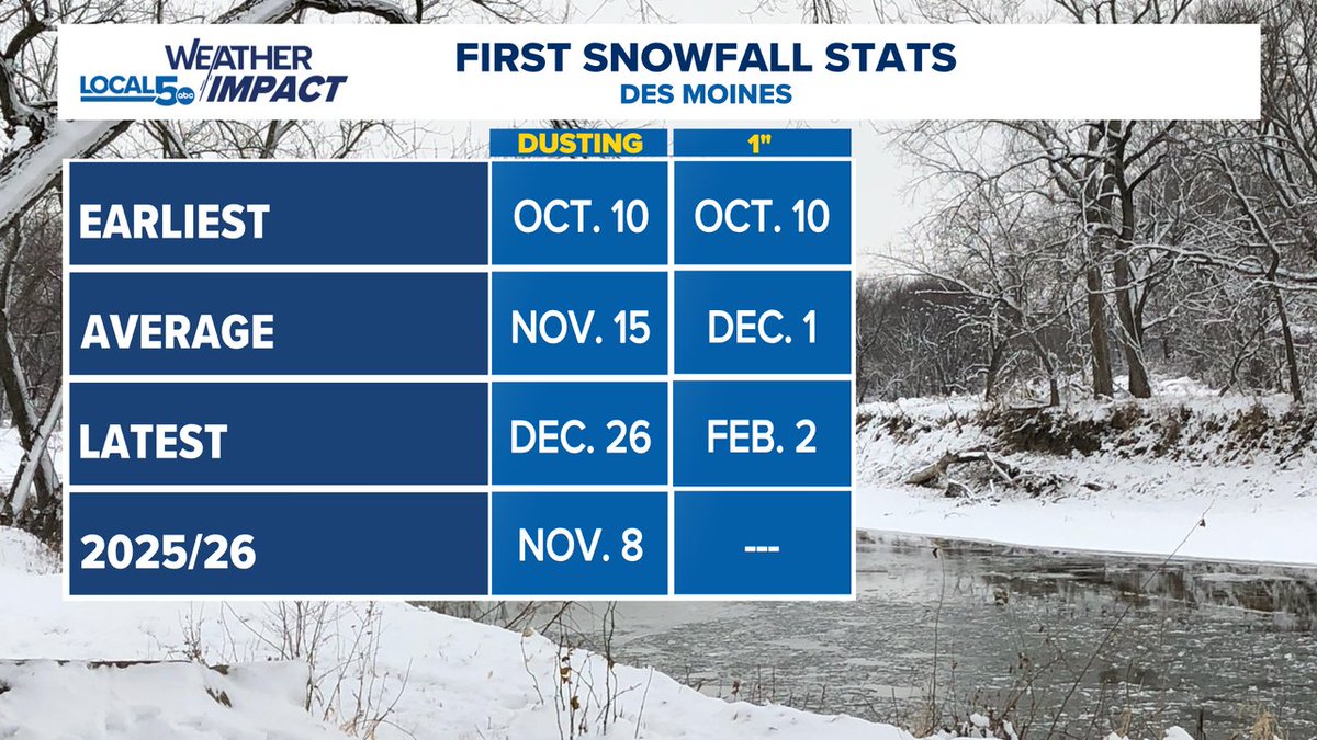
Going into the snow season a bit early on the 2025/26 season in Des Moines. We saw our first dusting a couple weeks ago. We should pick up that first inch (and a lot more) of snow a couple days earlier than average too. #IAWX #DSM
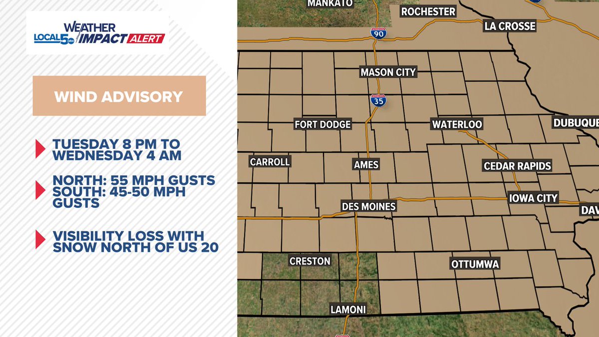
Tuesday night NW wind gusts are going to be potent. A few instances over 55 mph will be possible in northern Iowa into southern Minnesota. High profile vehicles should use caution. Add in snowflakes, low visibility and blowing snow becomes an issue. #IAWX #MNWX
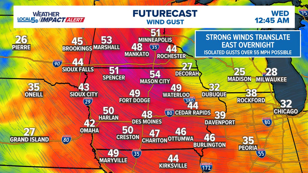
If this doesn't convince you the gradient wind is strong tonight, I don't know what will. Sioux City gusting to 67 mph as of 6 PM. Look for 55mph wind gusts to be common north of I80 as we go into the overnight. #IAWX
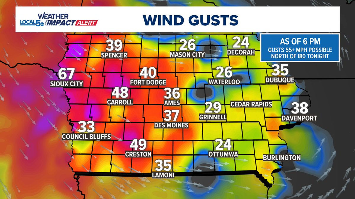
A Weather Impact Alert is in place from 8PM-4AM for wind gusts ramping up towards 55 mph across northern Iowa tonight. Visibility becomes a concern with a few snowflakes popping into areas north of US 20 too. Southern Iowa gusts will range from 45-50 mph. #IAWX #MNWX
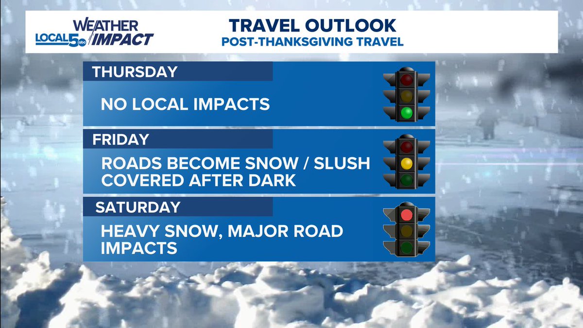
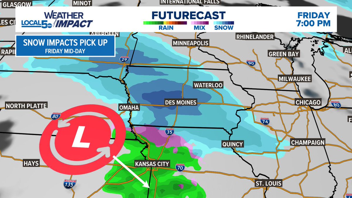
Travel leading up to Thanksgiving Day looks fine in central Iowa. Look for snow to begin to arrive, especially after dark on Friday with the heaviest and highest impacts on Saturday. Possible high end amounts looming for central Iowa. #IAWX


United States Trends
- 1. Brunson 6,801 posts
- 2. Knicks 12.4K posts
- 3. Celtics 13.2K posts
- 4. Jaylen Brown 6,080 posts
- 5. Duke 27.9K posts
- 6. Jordan Walsh N/A
- 7. #WWENXT 10.7K posts
- 8. Notre Dame 34.7K posts
- 9. Miami 94.3K posts
- 10. Bama 22.9K posts
- 11. Van Epps 125K posts
- 12. Mikal Bridges 1,473 posts
- 13. Tennessee 212K posts
- 14. Isaiah Evans 1,357 posts
- 15. Nashville 32.7K posts
- 16. Behn 77.1K posts
- 17. #kubball N/A
- 18. Boogie Fland N/A
- 19. #RHOSLC 2,644 posts
- 20. Harrison Barnes N/A
Dit vind je misschien leuk
-
 WHO 13 Weather
@WHOWeather -
 Brad Edwards
@BradEdwardsWX -
 Local 5 News
@weareiowa5news -
 KCCI Storm Team 8 Weather
@KCCIWeather -
 IEMBot DMX
@iembot_dmx -
 Ed Wilson
@EdWilsonWX13HD -
 NWS Des Moines
@NWSDesMoines -
 Iowa Weather Network
@IowaWXNetwork -
 Des Moines Arts Fest
@DMArtsFestival -
 Jeriann Ritter
@JeriannWX -
 IowaWeather.com
@IAStormChasing -
 Catch Des Moines
@catchdesmoines -
 Jason Sydejko KCCI
@JSydejkoKCCI -
 Downtown DSM USA
@downtownDSMUSA -
 Meteorologist Jason Parkin
@dsmwx
Something went wrong.
Something went wrong.