
ARCHIVED - NASA Ice
@NASA_ICE
Archived account that explored Earth's sea ice, land ice, snow and permafrost.
You might like


This account is now inactive. The page's content is frozen, but NASA continues to explore and study the icy regions of our home planet. For updates, follow us on @NASAEarth, @NASAGoddard, and other agency accounts. 📷 NASA/K. Ramsayer

Better together 🤝 NASA’s ICESat-2 satellite and GEDI instrument on the @Space_Station work together to give us the most complete view yet of Earth’s forests! They each map forests in 3D, helping scientists understand the carbon stored within our forests.
Many of you tuned in here for images of the far-flung fieldwork NASA scientists do in our planet's frozen realms. As we consolidate with @NASAEarth, share your favorite cool pic of glaciers, permafrost, sea ice, or an icy backyard pond. 📷: NASA/Maria José Viñas
An update: We're consolidating social media accounts later this month and will no longer be posting here. Be sure to follow @NASAEarth for the latest on NASA missions, research, and fieldwork that explores the frozen reaches of our home planet. 🧊 🛰️ ❄️ 📷: NASA/K. Mersmann

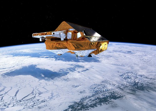
Cryo2ice is heading back to the Arctic! 🛰️🐻❄️🛰️ It’s a great opportunity. Earlier this year @ESA_EO CryoSat and @NASA_ICE ICESat-2 measurements became so closely spatiotemporally collocated that Cryo2ice observations are currently quasi-simultaneous. 🔗earth.esa.int/eogateway/news…
Did you celebrate Arbor Day Friday? #ICESat2 celebrates - and measures - trees all year long! The mission's global height data can monitor the height & health of forests around the world. Want to help? You can @DoNASAScience and observe tree heights with the @GLOBEProgram.
Celebrate our home planet - including its icy rivers, deltas, Antarctic islands, and glaciers - with NASA this #EarthDay! Write your name in @NASA_Landsat images here: go.nasa.gov/4jETaMq


It's almost Earth Day. Let’s celebrate our home planet from a unique viewpoint – space! Use our “Your Name in @NASA_Landsat” app to spell out your name (or a pet, family member, or significant other’s name) with Earth features seen by satellite: go.nasa.gov/4jETaMq

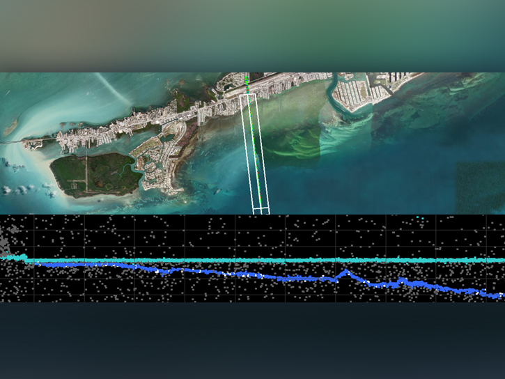
How do you use #ICESat2? One team puts the satellite's data to work validating the models used to generate coastal elevation maps, which are important for warning of hazards like tsunamis and storm surges. Full video: youtube.com/watch?v=CiXNIW…
How do you use #ICESat2? Some scientists are tapping into ICESat-2’s precise elevation data to monitor the ups and downs of water levels in reservoirs and lakes. Meet one who combines ICESat-2 and other data to study global water storage. Full video: youtube.com/watch?v=Zz3gW9…
How do you use #ICESat2? For this team of archaeologists, the satellite's precise data on sea level helps them study lost civilizations. Full video here: youtube.com/watch?v=d6c8P5…
How do you use #ICESat2? If you're interested in using lidar data to peer through coastal waters, tune into a @NASAEarthData webinar on the mission's new bathymetry data product. 🛰️🌊📉

A new global along-track #coastal and nearshore #bathymetry NASA ICESat-2 dataset is available. Want to learn more about the product and how to work with the data using SlideRule Earth? Join us tomorrow for a data training webinar. Register at go.nasa.gov/4hJlBYt
How do you use #ICESat2? This week, we’re meeting people who use NASA’s height-measuring satellite in creative ways to answer questions about our home planet. First up, mapping coastal seafloors from space. Full video: youtube.com/watch?v=379SrQ…
Join us for a NASA ICESat-2 data training webinar titled "Laser Altimetry Applications for a Changing World: Working with ICESat-2 Bathymetry Data" on Wednesday, April 9 at 2:00 p.m. EDT (-04:00 UTC). Learn more and register here: earthdata.nasa.gov/learn/webinars… #EarthData #NASA @NSIDC

Happy 2,000,000,000,000th, #ICESat2! 💚 🛰️ 🎉 You don't look a laser pulse over 1.9 trillion. NASA’s Earth-observing laser in orbit passed a milestone March 9, as it fired for the 2 trillionth time, measuring clouds off the coast of East Antarctica. blogs.nasa.gov/icesat2/2025/0…
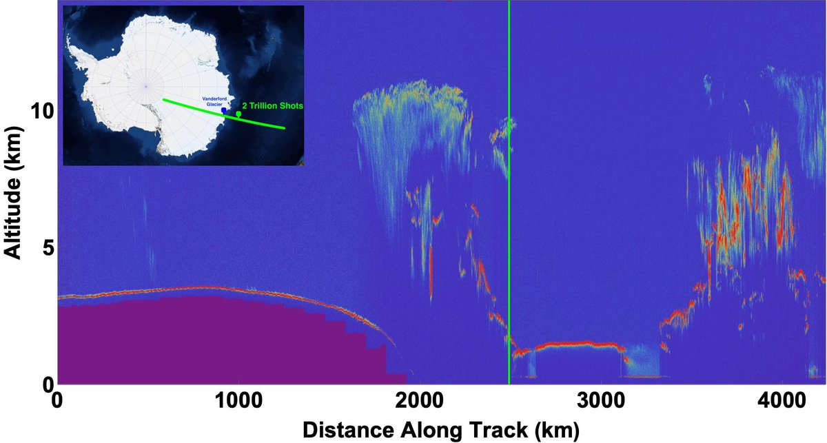
In September 2018, ICESat-2 fired its laser instrument for the first time. In the next few days, it will fire for the 2 trillionth time. While we wait to see what that shot will measure (Ice? Ocean? Clouds?), take a look back at those first photons. nasa.gov/science-resear…

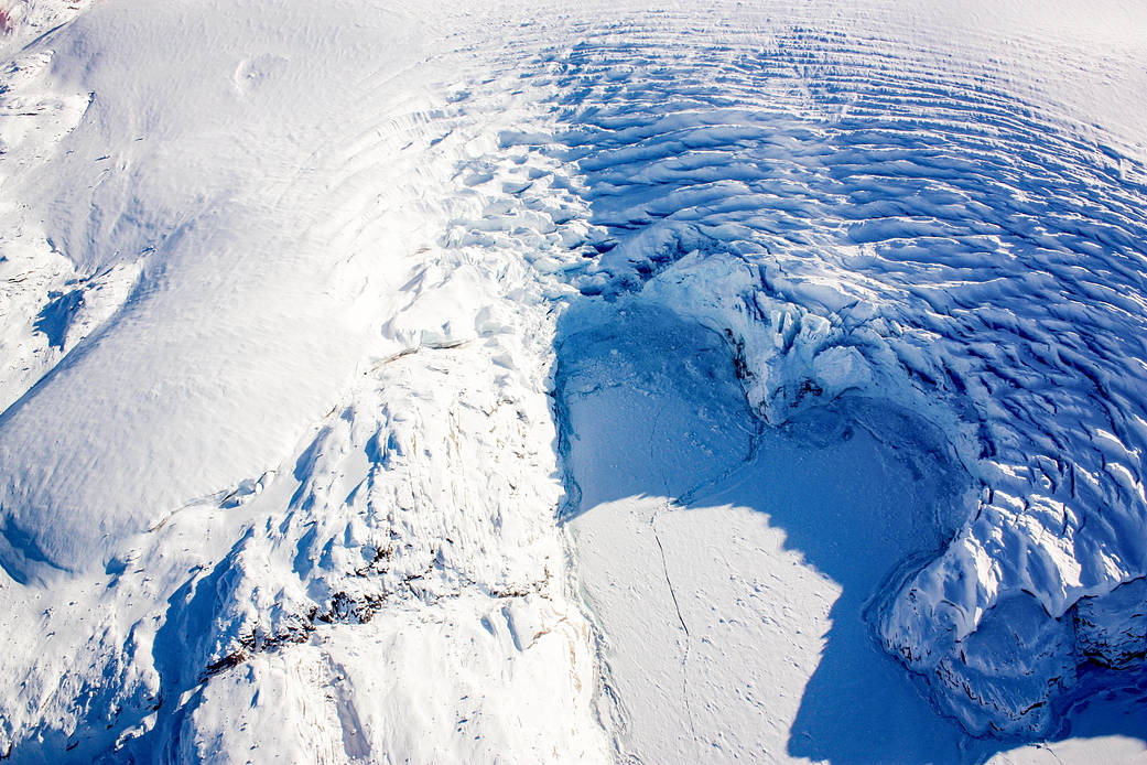
Don’t get dizzy 😵💫 This Iceberg, named A-84, has been ricocheting off parts of the Antarctic coastline over the past month. It has drifted about 250 kilometers (150 miles) from its point of origin. go.nasa.gov/4bth3DR
❄️ When you hear "Snow Day," do you think of sledding and hot cocoa? For our scientists, a snow day can be the perfect day for work! (Along with sledding...) In fact, a snow day is crucial for our researchers who gather data from the icy parts of our planet. ❄️


United States Trends
- 1. Good Monday N/A
- 2. Kash N/A
- 3. Yoko Taro N/A
- 4. Tourette N/A
- 5. Evangelion N/A
- 6. #MondayMotivation N/A
- 7. #MondayVibes N/A
- 8. #SiEresShowseraMCM N/A
- 9. DataHaven Testnet N/A
- 10. Fear God N/A
- 11. 960 SAT N/A
- 12. #blizzard N/A
- 13. #ราคีGALA N/A
- 14. Winona Ryder N/A
- 15. YESTERDAY THE TRUTH N/A
- 16. Fast and Furious N/A
- 17. $NVO N/A
- 18. Northeast N/A
- 19. State of the Union N/A
- 20. BAFTA N/A
You might like
-
 NASA Langley Research Center
@NASA_Langley -
 NASA Armstrong
@NASAArmstrong -
 NASA Technology
@NASA_Technology -
 NASA's Glenn Research Center
@NASAglenn -
 NASA Solar System
@NASASolarSystem -
 NASA Goddard
@NASAGoddard -
 NASA HQ PHOTO
@nasahqphoto -
 NASA Ames
@NASAAmes -
 Space 360
@Space360HQ -
 Chandra Observatory
@chandraxray -
 NASA Earth
@NASAEarth -
 NASA Universe
@NASAUniverse -
 NASA Wallops
@NASAWallops -
 National Space Society
@nss -
 NASA Events
@NASA_Events
Something went wrong.
Something went wrong.