
WEATHER STORM CHASER
@SapidStorm1
IM AM A WEATHER RADER PERSON WE COVER WEATHER AND OTHER TYPE OF WEATHER RELATED THINGS
You might like


there will probably be some motherships today🤩


This mesoscale convective vortex over Kansas looks more like a hurricane than #PTC1 does 🙄

Severe Thunderstorm Warning continues for Farmville VA, Hampden-Sydney VA and Hampden Sydney VA until 5:45 PM EDT


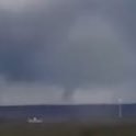
Video footage of the tornado I witnessed earlier today. A rare incredible view up the mouth of the funnel! Near the end you can hear me yell "tornado" as it started lofting trees. Unfortunately didn't catch that part, but in the video you can see pieces of debris in the air.


Police are advising anyone who does not live in the immediate area to stay away and those who do to remain vigilant. app.com/story/news/loc…
app.com
Cops ask public to remain vigilant after multiple black bear sightings in Atlantic Highlands
Police warn their have been multiple black bear sightings near Lenape Woods and Mount Mitchell.

BEACHES CLOSED: Heads up if you plan to hit the beaches this weekend! #njmornings newjersey.news12.com/late-spring-st…


MONSTER wind bag in Chester IL with large trees down across town. Rear inflow jet with very potent convective line. Power flashes in town as rear inflow jet ripped through. Chester is just south of St Louis along the MS River @accuweather

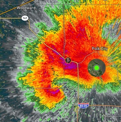
CONFIRMED Tornado Warning for Northeastern Decatur & Northwestern Norton County, KS. #kswx #weather #tornado


LZK issues Severe Thunderstorm Warning [wind: 60 MPH (OBSERVED), hail: 1.00 IN (RADAR INDICATED)] for Arkansas, Grant, Jefferson, Lonoke, Monroe, Prairie, Pulaski, Saline, White, Woodruff [AR] till 5:15 PM CDT mesonet.agron.iastate.edu/vtec/f/2022-O-…
![BobuxBad's tweet image. LZK issues Severe Thunderstorm Warning [wind: 60 MPH (OBSERVED), hail: 1.00 IN (RADAR INDICATED)] for Arkansas, Grant, Jefferson, Lonoke, Monroe, Prairie, Pulaski, Saline, White, Woodruff [AR] till 5:15 PM CDT mesonet.agron.iastate.edu/vtec/f/2022-O-…](https://pbs.twimg.com/media/FS1CRm_UEAIAlkx.jpg)
Today is the first day of the 2022 eastern North Pacific hurricane season. On average, the season sees 15 named storms, 8 hurricanes, and 4 major hurricanes. Development is not expected during the next 5 days but always follow here for the latest: nhc.noaa.gov/gtwo.php?basin…


Even days with quiet weather can lead to something spectacular. Get a load of this incredible dust devil captured by a local resident here in Midland off Loop 250 near the construction area. A textbook formation with impressive height. Quite the capture! #txwx


54 years ago today on May 15th, 1968, a widespread and deadly tornado outbreak struck a large region of the Mississippi Valley into the S Great Lakes region, including F5 tornadoes in Charles City and Oelwein IA and F4 tornadoes in Oil Trough and Jonesboro AR.


United States Trends
- 1. #FinallyOverIt 4,437 posts
- 2. Summer Walker 14.8K posts
- 3. Justin Fields 9,858 posts
- 4. 5sos 20.5K posts
- 5. #criticalrolespoilers 3,743 posts
- 6. Jets 68.5K posts
- 7. #TalusLabs N/A
- 8. Jalen Johnson 7,919 posts
- 9. Patriots 150K posts
- 10. Drake Maye 20.7K posts
- 11. 1-800 Heartbreak 1,171 posts
- 12. Judge 201K posts
- 13. Go Girl 25.4K posts
- 14. Henderson 22.4K posts
- 15. Wale 33.1K posts
- 16. AD Mitchell 2,411 posts
- 17. Disc 2 N/A
- 18. #everythingisalot N/A
- 19. Santana 14.3K posts
- 20. Robbed You 3,817 posts


Something went wrong.
Something went wrong.