
Dennis Clarijs
@dennisclarijs
Program Manager Services @ VITO Remote Sensing
You might like


I am presenting a webinar on Open Satellite Imagery in support of mountain sports. With this, I also want to reach people wo have never heard of EO before. Please RT, share with your #mountain loving friends, #climbing buddies, biking bro's etc! Register events.teams.microsoft.com/event/f87aa04f…


This year at #EXPANDEO2024 we're diving deep into the future of climate solutions with Copernicus data! 🌐 You can still register to join us online! ⤵️ expandeo.earsc.org #wherethemarketmeets


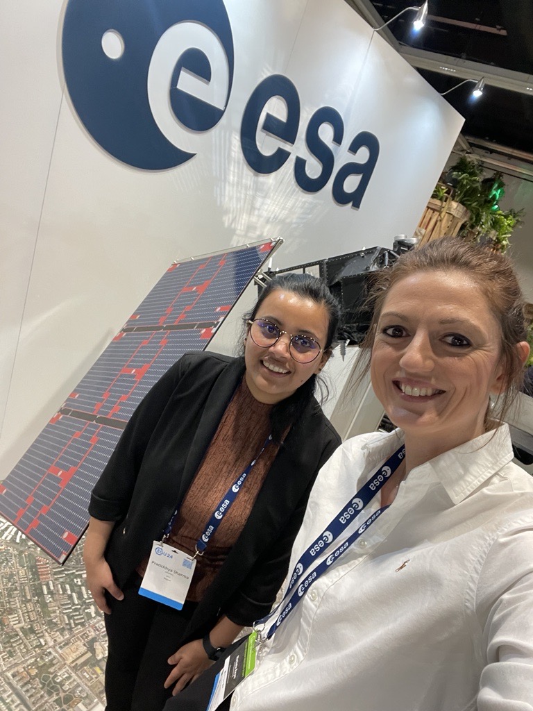
Greetings from #EGU2024 🤩📸 Colleagues Marketa Raym & Pratichhya Sharma are available to share more about our expertise & services to turn #EOdata into practical answers!💚 With applications like #CDSE, #openEO, #Terrascope, ... we move you forward! 🔗remotesensing.vito.be
📢 Last seats available for the on-site participation for the first #CDSE User Review Meeting! 🤗 Register now if you want to join us in Vienna 🇦🇹 15 April Can't join us on-site? No worries, register to join us online and don't miss a thing Read more 👉dataspace.copernicus.eu/userreviewmeet…

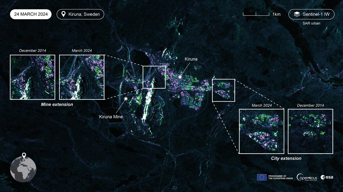
#Sentinel1A celebrates already a decade of #radar satellite data 🎉 It is the first #Copernicus satellite launched in 2014 valuable for many applications incl changing landscapes like the 🇸🇪 town #Kiruna which is moving because of decades of mining 👇 dataspace.copernicus.eu/gallery/2024-3…
Join the #Terrascope webinar next Thursday 👇 to learn more about the global #crop maps at 10 m resolution, which products are available via Terrascope, and the next steps @ESA_WorldCereal will take the upcoming 3 years! 🛰️🌾🗺️ 🗓️ 28 March ⏰ 16:00 ✍️ vito.zoom.us/webinar/regist…
🆕 in the #Copernicus #DataSpace Ecosystem Wildlife living on the Galápagos Islands! With info about the archipelago, species of #wildlife & #WorldWildlifeDay 🐬🦩🐢🪿💚 Download the image or discover the area yourself via the #CopernicusBrowser 👉 dataspace.copernicus.eu/gallery/2023-5…

⁉️ Do you use the #Copernicus #DataSpace Ecosystem? Let us know what you think! Which #EO data & services are important? Take 5 min. to complete the #CDSE User Review Survey! 📋👍👎 Your feedback is important to continue improving the ecosystem! 🌍 ➡️ surveymonkey.com/r/85STLMG

Flood maps of #Flanders based on #Sentinel1 satellite data 🛰️ This map shows the maximal observed flood extent between 01-01-2024 and 08-01-2024 Want to know more? Join our #webinar tomorrow: 🗓️ 27 February ⏲️ 16:00-16:45 CET ✍️ vito.zoom.us/webinar/regist…

🌧️Flood maps based on #Sentinel1 🛰️ made in November 2023 because of heavy rains 👇 Want to learn more about the use of #EOdata for #flood monitoring? Join the #Terrascope webinar next week: 🗓️ 27 February ⏲️ 16:00-16:45 CET ✍️ vito.zoom.us/webinar/regist… @lisa_landuyt @VMMbe
🍾🆕 On behalf of @belspo State Secretary @ThomasDermine signed an agreement with @VITObelgium to secure access to #satellite data & #imageprocessing services to continue supporting all Belgian users for at least another 5 more years. 🛰️🌍🤝 Read more ➡️bit.ly/TerrascopeII

🚀 Interesting post about the #Copernicus Data Space Ecosystem! 👇 @dennisclarijs talks about the future of 🇪🇺 #EO landscape, cutting-edge 🛰️ data & services, and how @CopernicusEU #DataSpace connects with downstream platforms such as @Terrascope_BE 🌍 blog.vito.be/remotesensing/…
blog.vito.be
The Copernicus Data Space Ecosystem, a game changer in the world of EO
Discover the new Copernicus Data Space Ecosystem, a new ecosystem for the Copernicus Sentinel data after the ESA distribution hubs and DIAS platforms.
Final countdown till the #EuropeanSpaceConf in #Brussels tomorrow to join the key stakeholders in the #European #space industry! 🛰️🇧🇪🇪🇺 Reach out to @StevenKrekels & @dennisclarijs to get in touch & see how we provide #EO services to support the #EU Space Ambition! 🤝 #EU2024BE

Save the date for this #webinar 👇 to learn more about: 🛰️ easy access to #opensource #EO data 👨💻integration with #Copernicus Data Space Ecosystem 🤝 #EOplaza to connect service providers & users 💿 the power of #openEO for cloud processing Register ➡️vito.zoom.us/webinar/regist…

🆕 Proud to be a part & to lead the consortium appointed by the JRC @EU_ScienceHub of the European Commission to implement the new #Copernicus Global Land Cover & Tropical Forest Mapping & Monitoring service (LCFM)! 🛰️💚🗺️ global - 10m resolution 🤩 ➡️ bit.ly/VITORS_LCFM

Kom jij 26/11 ook langs bij #TABLOO voor de #DVDW23? 🤗 Samen met onze experten ontdek je of ook jij 🧩 kan puzzelen met #satelliet beelden 🧙 kan toveren met #drone data 🔍 het onzichtbare in een veld zichtbaar kan maken Ontdek alle activteiten op ➡️bit.ly/VITORS_DvdW23

📢 26/11 is het @dagvdwetenschap 🤩 Kom langs bij #TABLOO en ontdek hoe we met 🌍 #satellieten de gezondheid van onze planeet in kaart brengen 🌊 #drones & #AI automatisch objecten detecten 🚜 #remotesensing de #landbouw duurzamer en slimmer maken bit.ly/VITORS_DvdW23🛰️🪄🗺️
Colleagues joining #BiDS23, @esa's Big Data from Space Conference 🤩 Eager to talk to you about the possibilities of the #Copernicus Data Space Ecosystem, innovative applications & the potential of big data in addressing global challenges ! 💡👩💻 ➡️ dataspace.copernicus.eu/news/2023-10-2…


Welcome to #BiDS23! Today will be fully dedicated to #satellite events🛰️ 🔗bigdatafromspace2023.org/programme Find your way around with the conference app📲 🔗bigdatafromspace2023.org/bids23-event-a… @eusatcen @EU_ScienceHub @ESA_EO
🥳🥳🥳 #WasteWatchers heeft zonet de #GeospatialAward voor beste project & de publieksprijs gewonnen tijdens de #trefdag23! 🙏 Samen met #RiverCleanup stellen we burgers in staat om met #drones & #AI zwerfvuil in kaart te brengen! 💙👉 blog.vito.be/remotesensing/… @digi_vlaanderen


Interested in cloud-free image #timeseries? ☁️🛰️🌍 Discover the #CropSAR services, both available via #Terrascope #EOplaza: 👉 #CropSAR #field level ideal for #crop monitoring 👉 #CropSAR #pixel level to analyse regions & serve multiple applications 👀➡️blog.vito.be/remotesensing/…
blog.vito.be
New CropSAR service provides Cloud-Free Time Series at Pixel Level
Learn more about the upscaling of the CropSAR technology to provide an additional CropSAR service to generate cloud-free time series at pixel level
🆕 We've upscaled our #CropSAR technology to generate cloud-free #timeseries at #pixel level. 🗺️ This not only allows us to analyse an entire region instead of one field but also extends the use beyond #agriculture 🤩 @K_VanTricht explains more about ⤵️ blog.vito.be/remotesensing/…
blog.vito.be
New CropSAR service provides Cloud-Free Time Series at Pixel Level
Learn more about the upscaling of the CropSAR technology to provide an additional CropSAR service to generate cloud-free time series at pixel level


United States Trends
- 1. Good Friday 43.1K posts
- 2. #FridayVibes 3,422 posts
- 3. Summer Walker 20.1K posts
- 4. #FinallyOverIt 6,504 posts
- 5. Wale 35.2K posts
- 6. Happy Friyay 1,061 posts
- 7. #FridayMotivation 2,178 posts
- 8. #fridaymorning 1,143 posts
- 9. Go Girl 26.7K posts
- 10. RED Friday 2,083 posts
- 11. #FursuitFriday 10.3K posts
- 12. Meek 6,162 posts
- 13. Robbed You 4,557 posts
- 14. Domain For Sale 14.8K posts
- 15. Bihar 332K posts
- 16. 1-800 Heartbreak 1,728 posts
- 17. 5sos 23.6K posts
- 18. Bubba 8,196 posts
- 19. Justin Fields 10.4K posts
- 20. Disc 2 1,069 posts

Something went wrong.
Something went wrong.