
Geo_Spatialist
@geo_spatialist
IG/Twitter/Threads @geo_spatialist Bluesky @geospatialist.bsky.social
You might like


1/2 Geologic Map of South America - The Geological Society of America / The American Geographical Society / USGS - 1950 3D Render Close ups below #arcgispro #b3d #geology #geography #gis #cartography #SouthAmerica
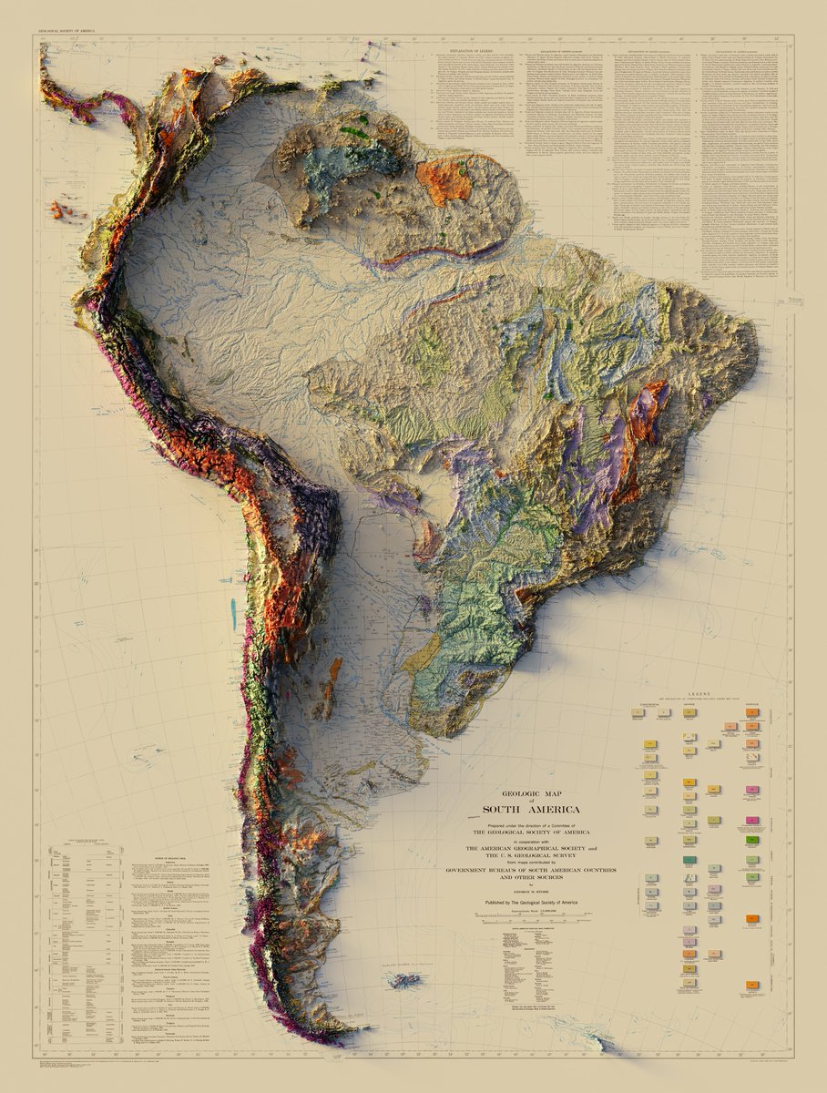
Flying around a vintage map.
One last try at bringing this beautiful Swiss Alps map to life. Animation renders just take so long. Some day I may try a render farm. #arcgispro #b3d #3Danimation #Switzerland #geography #GIS
If you want a higher res version of the Mount St. Helens patent map, you can get it here: drive.google.com/file/d/1dtHwC7… #pnw #mountsthelens #arcgispro #b3d

I know a 3D rendered LiDAR surface when I see one, Peacemaker. Spotted in Season 2 Episode 7 of #Peacemaker.

Carte de la France - Institut Géographique National - 1971 3D Render with Bathymetry #France #ArcGISPro #cartography #b3d


Topographic Map, Acadia National Park and Vicinity, Hancock County Maine - US Geological Survey - 1942 3D Render #AcadiaNationalPark #Acadia #AcadiaMaine #BarHarborMaine #BarHarbor #ArcGISPro #cartography #b3d


Ketchikan, Alaska - 1955 - US Geological Survey - 1955, limited revisions 1976 3D Render #Alaska #Ketchikan #KetchikanAlaska #ArcGISPro #cartography #b3d


Juanita Arch - Colorado, Mesa Co. - USGS / US Atomic Energy Commission - 1949 3D Render #colorado #ArcGISPro #cartography #b3d


I probably enjoy using the clone tool in photoshop like a little magic window too much. #Yosemite #YosemiteNationalPark #ArcGISPro #b3d #Photoshop
And immediately gets bookmarked into my inspirations folder. esri.com/arcgis-blog/pr…
esri.com
Hiking to the Clouds (Someday)
A map of the Cactus to Clouds trail near Palm Springs, California and how to recreate it in ArcGIS Pro with cartography tools.


United States Trends
- 1. #FinallyOverIt 2,456 posts
- 2. Justin Fields 9,545 posts
- 3. Jets 67.4K posts
- 4. Patriots 145K posts
- 5. Drake Maye 19.7K posts
- 6. Jalen Johnson 6,584 posts
- 7. Summer Walker 11.4K posts
- 8. 5sos 18.8K posts
- 9. Henderson 21.6K posts
- 10. Judge 189K posts
- 11. AD Mitchell 2,332 posts
- 12. Pats 14.2K posts
- 13. #criticalrolespoilers 2,599 posts
- 14. 1-800 Heartbreak N/A
- 15. Diggs 10.6K posts
- 16. Santana 13.7K posts
- 17. Cal Raleigh 7,683 posts
- 18. #GreysAnatomy 2,102 posts
- 19. Go Girl 24.5K posts
- 20. #zzzSpecialProgram 1,348 posts
You might like
-
 Helen McKenzie
@helenmakesmaps -
 Tom Patterson
@MtnMapper -
 Topi Tjukanov
@tjukanov -
 Matt Malone
@MatthewHMalone -
 John Nelson
@John_M_Nelson -
 Ujaval Gandhi
@spatialthoughts -
 OnlMaps
@onlmaps -
 Aava Santiago
@aavasantiago -
 Daniel Goddard
@DanielGoddard -
 Charlie Verdel
@CSVerdel -
 NACIS
NACIS
@NACIS -
 Kenneth Field
@kennethfield -
 🥔🗺️ ᴘᴏᴋᴀᴛᴇᴏ ᴍᴀᴘs
@pokateo_maps -
 Alasdair Rae
@undertheraedar -
 Sarah Bell
@sarahbellmaps
Something went wrong.
Something went wrong.