
R spatial
@geospatial_r
A twitter account for #rspatial community that retweets everything about #rspatial, #geospatial, #GIS, #remotesensing, #rstudio, #rstats.
You might like


What would happen in Europe if the sea level raises 50m? A "what-if" map, made with {elevatr} #RStats #rspatial

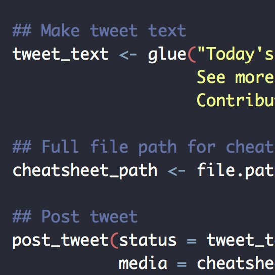
Today's #rstats cheatsheet: shiny Download: raw.githubusercontent.com/rstudio/cheats… See more: rstudio.com/resources/chea… Contribute your own: github.com/rstudio/cheats…


Just a tiny example with a ~1 GB .gpkg file (with an index)...the equivalent GeoParquet is ~600 MB (without an index), can be read into #rstats sf in a ~ 5 s, and can be written in ~3 s (mostly because of the 'arrow' package's use of ALTREP for strings) #rspatial


The {regional} package calculates intra-regional and inter-regional similarities based on user-provided spatial vector objects (regions) and spatial raster objects (cells with values). Learn more at jakubnowosad.com/regional/. #rspatial #rstats #gischat


Sorry @milos_agathon , today is my turn! (Although probably you already made this map). Life expectancy at birth, 2019. Made with #rspatial following this blog post: milospopovic.net/inset-graph-wi…


I updated the website of my book "Geospatial Health Data" with the bs4 #bookdown template🌎📊💻Ready to teach in @ENAR_ibs! ✈️ 👉 paula-moraga.github.io/book-geospatial 💻#rstats #rspatial🗺️#diseasemapping #GIS ✨#rshiny📊#RINLA 🌍#spatialepidemiology 🌈#epitwitter 📕 @CRC_MathStats

Right geo nerds! Does anyone have opnions on the best COG GeoTIFF spec for a single band raster when using georaster-layer-for-leaflet / leafem::leafem::addGeotiff?Happy to sacrifice accuracy/precision for performance! #rspatial #gischat #gdal🙏

#rspatial #gischat using QGIS instead of other interactive map packages in R: an example. I use postgis in the background (st_write in the end of the pipe), didn't manage to notify the database so I use a 0.1 interval refresh rate. For me it is a game changer.

7/n I ran the same survey for R. Guess what! 90% love RStudio. So it’s simpler to pick R. Everyone uses RStudio. We all learn the same way. But that’s just the 2nd reason.
If you’re looking for a 6-figure data scientist job, what if I told you that #R was a smarter choice than #python? You’d probably laugh at me right? Well please read on… #rstats


Recently I compared the performance of the most popular packages for vector data processing in #python and #rstats. It seems that {terra} is mainly used for raster data, but it does quite well with vectors too. #rspatial #gischat


🤔How do others use ds in your industry? 🙋🏼♀️How do you start a meetup at your company? This site has been an idea for a while & makes me so happy to share. Lmk what you think. I'd love to keep adding resources (blogs, meetups, tips) from all♥️ rstudio.com/champion/ #rstats


My first viz using R!!! What do you think??? Can't wait to learn more! #ggplot2 #Rstudio #DataAnalytics #DataScience #data


I'm *soooo* close to wrapping up the development sprint I've been on for the last month. I've made several new mapping functions that I split off into a separate {birdseyeview} package (mainly to keep #overedge from getting too complex) elipousson.github.io/birdseyeview/r… #rspatial
Getting excited for preliminary read prototyping in #rstats geoarrow 🌏⏩! Can now read WKB-encoded parquet files (as written by sfarrow and geopandas), with some exciting preliminary benchmarks (11 million points + attributes to sf in 5 ish seconds). #rspatial


#rspatial Do we need a package for using our own pictures as base maps? I don’t know, but anyway we have it! {rasterpic} 📦 is now on CRAN, and we can convert our pngs to spatial rasters like this cran.r-project.org/package=raster…


BAM! Thanks so much @TimSalabim3 for helping with this. I can't quite get over how well this works! >1million lines rendered in the browser (v fast) with no lag at all. Issue was some broken geometries and needing to add the src=TRUE arg in leafgl::addGlPolylines. #rspatial

Okay so a few people seemed interested in this so here is the issue on the {leafgl} github: github.com/r-spatial/leaf…. A regional subset of the river network renders nicely for all {leafgl}, {mapdeck} and {rdeck} but I was only able to render the full dataset with {rdeck}.


So the #rspatial workflow would be to tile first, load each tile separately and then process? I’m not sure about this because I am trying to classify the imagery with one set of samples for training and validation. Would I have to have individual samples for each tile? Thanks!
Okay so a few people seemed interested in this so here is the issue on the {leafgl} github: github.com/r-spatial/leaf…. A regional subset of the river network renders nicely for all {leafgl}, {mapdeck} and {rdeck} but I was only able to render the full dataset with {rdeck}.


United States Trends
- 1. #hazbinhotelseason2 33.2K posts
- 2. Good Wednesday 19K posts
- 3. Northern Lights 48.1K posts
- 4. #HazbinHotelSpoilers 3,217 posts
- 5. ADOR 26.6K posts
- 6. #huskerdust 9,109 posts
- 7. Hanni 8,793 posts
- 8. Vaggie 6,364 posts
- 9. MIND-BLOWING 35.1K posts
- 10. #chaggie 4,943 posts
- 11. #Aurora 10.4K posts
- 12. Carmilla 2,628 posts
- 13. SPECTACULAR 25.3K posts
- 14. Wike 238K posts
- 15. H-1B 39.6K posts
- 16. Superb 22.9K posts
- 17. Justified 18.7K posts
- 18. TERRIFIC 15.8K posts
- 19. H1-B 4,525 posts
- 20. STEM 15.4K posts
You might like
-
 Helen McKenzie
@helenmakesmaps -
 Robin Lovelace
@robinlovelace -
 IEEE Geoscience and Remote Sensing Society
@IEEE_GRSS -
 Vimal Mishra
@vmishraiit -
 Miguel Hernán
@_MiguelHernan -
 Sayings Of Imam Ali
@GemsOfImamAli -
 Yan Holtz
@R_Graph_Gallery -
 R Consortium
@RConsortium -
 Lee R Berger
@LeeRberger -
 Bill Sutherland
@Bill_Sutherland -
 MappingGIS 🚀🌍
@MappingGIS -
 ESA Frontiers
@ESAFrontiers -
 John Nelson
@John_M_Nelson -
 Open Source Ecology
@OSEcology -
 Chelsea Parlett
@ChelseaParlett
Something went wrong.
Something went wrong.