
Spacesium
@Spacesium
Loading a data-driven globe 🌏 Cloud-based software enables simple and reliable 3D data processing and management. Ai and ML on Geo-Data. 🧠 gis-ceo @qhongtran
قد يعجبك


Introducing Spacesium Scout: Unleash Your Project's Potential! 🎇 Spacesium Scout is a online platform revolutionizing large-scale project visualization and 3D #spatial data management. Seamlessly navigate infrastructure, mining, construction, environmental, and mapping project
Announcement!! 🟢🟢🟢 We have released our #geoai toolbox for ESRI ArcPro. This allows you to detect all the safety hazards on your construction or mining roads. Find out more here - spacesium.com/spacesium-scou… #mining #technology #Esri #arcpro #gis #miningtech


How do you use your drone or aerial data to detect hazards on a site? ⚒️🚐🦺 This dataset was captured using the Geosun Navigation GS-260X over a mine site. 🗺️ The Spacesium Road Safety Compliance Toolbox (RSCT) detected all the hazards in 4 mins. 🍰


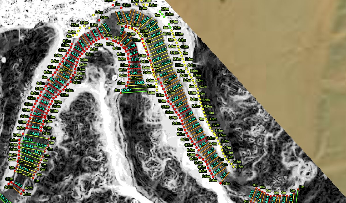
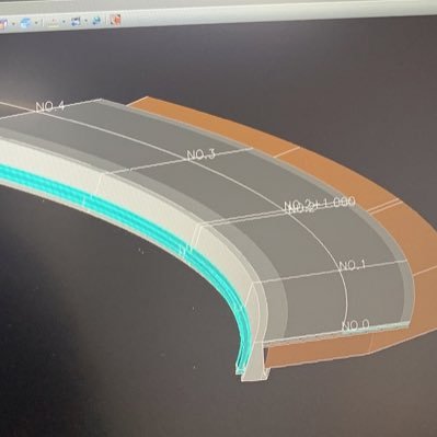
How to use spatial software to measure designs and if roads are maintained? The @Spacesium team behind the Scout3D platform has released a new software tool to monitor, measure and managing haul roads for performance and safety. 📷


United States الاتجاهات
- 1. #AskFFT N/A
- 2. StandX 1,694 posts
- 3. #sundayvibes 6,232 posts
- 4. Good Sunday 70.7K posts
- 5. Scott Adams 9,844 posts
- 6. Nigeria 926K posts
- 7. Full PPR 1,173 posts
- 8. #2YearsWithGolden 16.8K posts
- 9. #NicxStrava 2,647 posts
- 10. JUNGKOOK IS GOLDEN 18.7K posts
- 11. #NUFC 7,508 posts
- 12. West Ham 6,389 posts
- 13. Navy Federal N/A
- 14. Dowdle 1,727 posts
- 15. Carlos Manzo 485K posts
- 16. Bam Knight N/A
- 17. Newcastle 19.5K posts
- 18. Yura 10.4K posts
- 19. Dike 2,203 posts
- 20. Yankees 18.8K posts


Something went wrong.
Something went wrong.