#arcgisstorymap search results

#SIG2021 Concours 24H du SIG : les inscriptions sont ouvertes. Ce concours se déroule sur 24h pendant lesquels les participants en binôme devront traiter un sujet et produire une #ArcGISStoryMap Envoyez vos candidatures à [email protected] avant le 15 septembre 2021.


Watch #newyorkcity morph from colonial village to 21st-century metropolis in our #ArcGISStoryMap storymaps.arcgis.com/stories/c54162…
Lauréats du Concours des 24H Nicolas Haury - Unilasalle & Seny Deme - Université Paris 8 et leur tutrice Sylvie Beauvivre - GEOFIT 👏👏 Belle story map sur les risques naturels littoraux et les impacts sur l'Homme @geofit_fr @SylvineB44 #arcgisstorymap

I'm working on an #ArcGISStoryMap about #Indianapolis, my home town...just got via eBay a 1960 street map of Indy. Mint condition, pre-freeways, and exactly the map I marked up as a kid with the routes of my bike rides!

What's this number? It's the cumulative total you walked and ran during the #esri2020run (9,804 miles)—equivalent to the distance from Redlands, CA, to South Africa! Summary #ArcGISStoryMap here arcg.is/1GjKni

Risques et nuisances en Val-de-Marne (XVIIIe - XXe siècle) en story map De 1780 à 1945 découvrez comment le territoire du Val-de-Marne a vécu, subi et s'est adapté aux évolutions urbaines et économiques. archives.valdemarne.fr/r/358/la-story… @valdemarne_94 @Archives_94 #ArcGISStoryMap


Descubre las tradiciones navideñas más curiosas que hay alrededor del mundo. ¿Cuál mantenemos en España? 😉 Gran #ArcGISStoryMap de @EsriColombia ¡#FeGISNavidad a tod@s los giser@s! 🎄 #MerryGISmas #FelizNavidad 🌍 arcg.is/1bjTKD0

I love this #ArcGISStoryMap about the Punta Banda Estuary in #BajaCalifornia. Why? It's got English and Spanish versions... ...it makes elegant use of express maps... ...and it's about birds (I love birds)! arcg.is/14bryr


Esri cartographer, Allen Carrol (ArcGIS StoryMaps team) demonstrates how to adjust the appearance of various visuals within an #ArcGISStoryMap narrative to create a unified look and feel that complements the mood of your story. ow.ly/rI8r50I5kjT

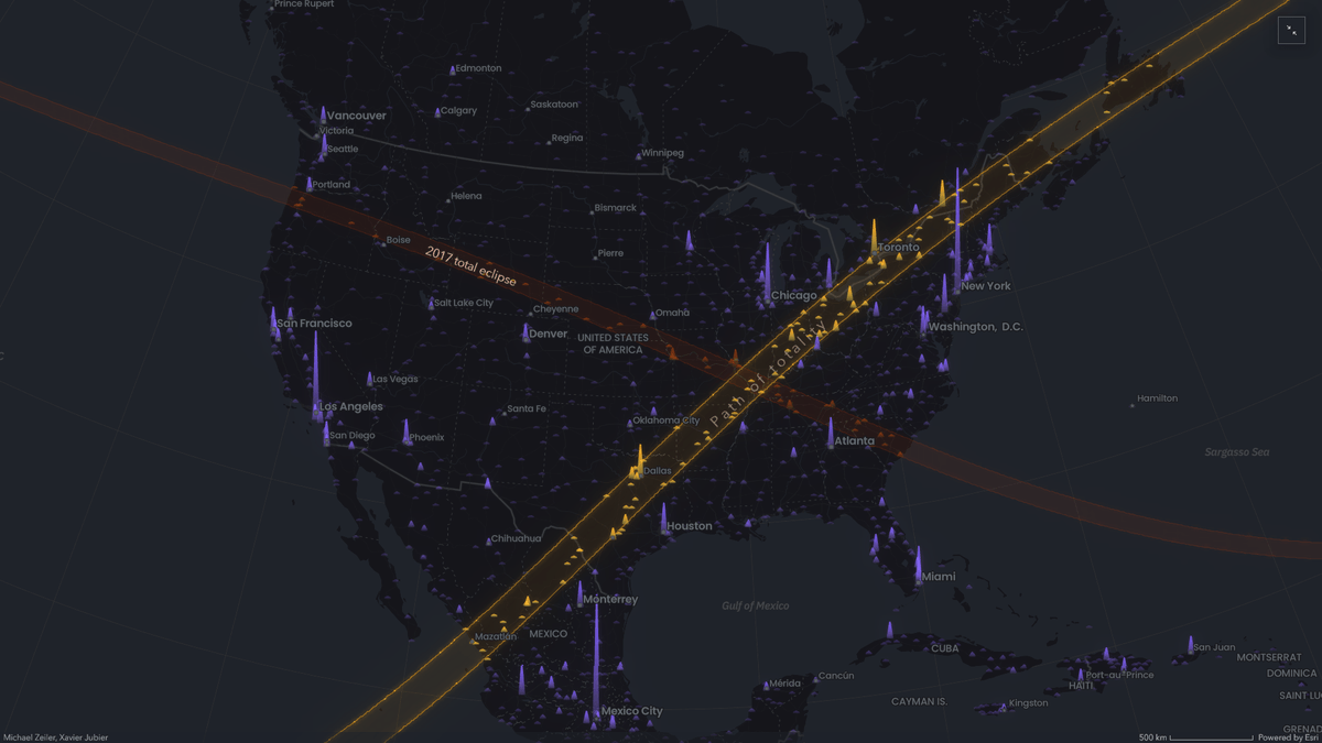
🎓☀️🌒 Eclipse map tutorial: Learn how to create a map of the April 8, 2024, solar eclipse in ArcGIS Map Viewer and follow along with the #ArcGISStoryMap. ow.ly/o2y350RaNNm

Masoud Mohammadi and the #GISheroes at @ourcbcity developed the Smart Data initiative championing data transparency, accountability and innovation to create a brighter future for their constituents. Check out this #ArcGISStoryMap on their 20 year plan: bit.ly/2UBf1v5

From #Waukesha County, an #ArcGISStoryMap summarizing the cool stuff that can be done with drones and mapping technology storymaps.arcgis.com/stories/d637eb…


Esri cartographer, Allen Carrol (ArcGIS StoryMaps team) demonstrates how to adjust the appearance of various visuals within an #ArcGISStoryMap narrative to create a unified look and feel that complements the mood of your story. ow.ly/Niqi50I2Q6H

After the devastating bushfires on Kangaroo Island, the #GISheroes at @SAEnvirWater created this #ArcGISStoryMap to raise awareness that despite impacts on wildlife and their habitats, the bush will regenerate and nature-based tourism is alive and well. bit.ly/38Rp873

🌳 Aujourd’hui, 21 mars, c'est la Journée internationale des forêts. A cette occasion, revenons sur une story map qui met en avant les arbres. Prenons-nous soin d’eux de manière responsable ? 👉storymaps.arcgis.com/collections/cf… @JIF_France #JIF2022 #deforestation #ArcGISStoryMap


NEW #K12educators you have until Sept 18th to submit your #ArcGISStoryMap for the 2025 #NewTeacher Competition!
New #k12 + #preservice #teachers: Check out 2025's @esricanada #NewTeacherCompetition that recognizes #creativity, #innovation, + dedication to enhancing #geoliteracy, #spatialawareness using #ArcGIS. Learn more + get involved! There are great prizes! storymaps.arcgis.com/stories/de6588…

🚀 Got an inspiring ArcGIS StoryMap? 🌍 Share your innovative GIS solutions with the community at the Esri UAE User Conference! 🗣️ Submit your #ArcGISStoryMap today: shorturl.at/0MgzI Let’s inspire and connect! 💡 #EsriUAEUC #GIS #ArcGIS #Esri #Storytelling

Explore this #ArcGISStoryMap of Nashville, TN, flood zones. For the most vulnerable communities, climate change is a “risk multiplier” that does not affect everyone equally. ow.ly/7yyC30sHlwH #Climate #Resilience.


Explore this #ArcGISStoryMap of Nashville, TN, flood zones. For the most vulnerable communities, climate change is a “risk multiplier” that does not affect everyone equally. ow.ly/w8kJ30sHaXZ #Climate #Resilience.

May 30th is around the corner! That is the last day to submit your #ArcGISStoryMap for the #NewEducatorAward competition. Don't miss out on the great $$ prizes! All the best to the participants. resources.esri.ca/education-and-… #k12resource #mappingfun #newteachers #ArcGIS #GIS

NEW #K12educators you have until Sept 18th to submit your #ArcGISStoryMap for the 2025 #NewTeacher Competition!
New #k12 + #preservice #teachers: Check out 2025's @esricanada #NewTeacherCompetition that recognizes #creativity, #innovation, + dedication to enhancing #geoliteracy, #spatialawareness using #ArcGIS. Learn more + get involved! There are great prizes! storymaps.arcgis.com/stories/de6588…

Esri's StoryMap Competition is heating up!! Another one of the finalists that I really like is this one from Triangle Land Conservancy focused on Watershed Protection. #EsriWater #ArcGISStoryMap ow.ly/Tote50UZACh
storymaps.arcgis.com
Watershed Protection Benefits in the Upper Neuse River Basin
An interactive analysis of land conservation climate benefits made possible by the Triangle's most innovative watershed protection program
🚀 Got an inspiring ArcGIS StoryMap? 🌍 Share your innovative GIS solutions with the community at the Esri UAE User Conference! 🗣️ Submit your #ArcGISStoryMap today: shorturl.at/0MgzI Let’s inspire and connect! 💡 #EsriUAEUC #GIS #ArcGIS #Esri #Storytelling
#GISDay Modèle d’évènement de story map Vous organisez un événement dans le cadre du #GISDay2024? Utilisez le nouveau modèle d’évènement présent dans les story map et présentez avec une ressource de marque pour votre évènement. eu1.hubs.ly/H0djXzm0 #ArcGISStorymap #EsriFrance

🌟Check out CLEAR’s new #ArcGISStoryMap on VOCs in Detroit, developed with the RT team by @WSUHumClinic intern & PhD student D’Arcy Cook storymaps.arcgis.com/stories/565772…
storymaps.arcgis.com
Volatile Organic Compounds in Detroit and Southeast Michigan
Center for Leadership in Environmental Awareness and Research
Explore this #ArcGISStoryMap of Nashville, TN, flood zones. For the most vulnerable communities, climate change is a “risk multiplier” that does not affect everyone equally. ow.ly/7yyC30sHlwH #Climate #Resilience.
Explore this #ArcGISStoryMap of Nashville, TN, flood zones. For the most vulnerable communities, climate change is a “risk multiplier” that does not affect everyone equally. ow.ly/w8kJ30sHaXZ #Climate #Resilience.

GeoMarvel partnered with WQRF on the Water Contaminant Mapping Tool & #ArcGISStoryMap, which visualizes contamination in public drinking water systems that serve nearly 88% of the U.S. population. Learn more in our latest portfolio entry. → bit.ly/3MxM6mn

🚀🌍 We are honored to have worked with #PureWestEnergy to digitize their annual #sustainability report into an interactive #ArcGISStoryMap. #EsriPartner #GIS Read the Esri Case Study article → bit.ly/3Zml2yg View the #PureWest StoryMap → bit.ly/3XlKKA9


Welcome to #EsriUC2024! If you are interested in coordinate systems, transformations, #MapProjections, and you would like to learn more about these or you have specific questions, here is a #ArcGISStoryMap will all information you need to know. @EsriUC storymaps.arcgis.com/stories/497360…
storymaps.arcgis.com
Coordinate Systems
Esri User Conference 2025
May 30th is around the corner! That is the last day to submit your #ArcGISStoryMap for the #NewEducatorAward competition. Don't miss out on the great $$ prizes! All the best to the participants. resources.esri.ca/education-and-… #k12resource #mappingfun #newteachers #ArcGIS #GIS
🎓☀️🌒 Eclipse map tutorial: Learn how to create a map of the April 8, 2024, solar eclipse in ArcGIS Map Viewer and follow along with the #ArcGISStoryMap. ow.ly/o2y350RaNNm
Plongez dans les profondeurs de notre lien vital avec l'océan 🐟 Découvrez comment nos choix quotidiens influent sur la santé de cet écosystème vital, et apprenez comment nous pouvons agir. 🌍 eu1.hubs.ly/H08ydgF0 #ProtégeonsLOcéan #ArcGISStoryMap #biodiversité #EsriFrance


🎓☀️🌒 Eclipse map tutorial: Learn how to create a map of the April 8, 2024, solar eclipse in ArcGIS Map Viewer and follow along with the #ArcGISStoryMap. ow.ly/XiKC50R9HXc

Félicitations à l'équipe de l'UMR Espace d'Avignon pour avoir remporté le Prix "Apport de la recherche sur les crises de sécurité civile" au 16ème Forum d'Information sur les Risques Majeurs avec une #ArcGISStoryMap ! 👏 eu1.hubs.ly/H07MkV20 #EsriFrance #UMREspaceAvignon

本日2月20日は、#旅券の日。 意外と知らない?!世界三大○○シリーズを #ArcGISStorymap で紹介します。 世界三大英雄は、ガイウス・ユリウス・カエサル、ナポレオン・ボナパルト。 さて、あと1人は誰でしょう?? 正解はこちらbit.ly/3wjZaXD

Descubre las tradiciones navideñas más curiosas que hay alrededor del mundo. ¿Cuál mantenemos en España? 😉 Gran #ArcGISStoryMap de @EsriColombia ¡#FeGISNavidad a tod@s los giser@s! 🎄 #MerryGISmas #FelizNavidad 🌍 arcg.is/1bjTKD0
Raconter le #Rhône Découvrez cette belle storymaps écrite par des étudiants de l'ENS et leurs professeurs (INSA, CNRS...) autour d'un projet d'écriture collaboratif de mise en récit du fleuve pour le grand public et les scolaires 👋 storymaps.arcgis.com/stories/68d295… #ArcGISStoryMap
Retrouvez des réalisations cartographiques d'élèves, étudiants et enseignants (sous forme de story map, cartes, …) mettant en valeur le travail réalisé d’après de la ressource Géorep. 👋 👉georep.nc/education/vos-… @Georep_NC #NouvelleCalédonie #ArcGISStoryMap #SIG
Watch #newyorkcity morph from colonial village to 21st-century metropolis in our #ArcGISStoryMap storymaps.arcgis.com/stories/c54162…
What's this number? It's the cumulative total you walked and ran during the #esri2020run (9,804 miles)—equivalent to the distance from Redlands, CA, to South Africa! Summary #ArcGISStoryMap here arcg.is/1GjKni
#SIG2021 Concours 24H du SIG : les inscriptions sont ouvertes. Ce concours se déroule sur 24h pendant lesquels les participants en binôme devront traiter un sujet et produire une #ArcGISStoryMap Envoyez vos candidatures à [email protected] avant le 15 septembre 2021.
Risques et nuisances en Val-de-Marne (XVIIIe - XXe siècle) en story map De 1780 à 1945 découvrez comment le territoire du Val-de-Marne a vécu, subi et s'est adapté aux évolutions urbaines et économiques. archives.valdemarne.fr/r/358/la-story… @valdemarne_94 @Archives_94 #ArcGISStoryMap
Lauréats du Concours des 24H Nicolas Haury - Unilasalle & Seny Deme - Université Paris 8 et leur tutrice Sylvie Beauvivre - GEOFIT 👏👏 Belle story map sur les risques naturels littoraux et les impacts sur l'Homme @geofit_fr @SylvineB44 #arcgisstorymap
Descubre las tradiciones navideñas más curiosas que hay alrededor del mundo. ¿Cuál mantenemos en España? 😉 Gran #ArcGISStoryMap de @EsriColombia ¡#FeGISNavidad a tod@s los giser@s! 🎄 #MerryGISmas #FelizNavidad 🌍 arcg.is/1bjTKD0
I'm working on an #ArcGISStoryMap about #Indianapolis, my home town...just got via eBay a 1960 street map of Indy. Mint condition, pre-freeways, and exactly the map I marked up as a kid with the routes of my bike rides!
I love this #ArcGISStoryMap about the Punta Banda Estuary in #BajaCalifornia. Why? It's got English and Spanish versions... ...it makes elegant use of express maps... ...and it's about birds (I love birds)! arcg.is/14bryr
🌳 Aujourd’hui, 21 mars, c'est la Journée internationale des forêts. A cette occasion, revenons sur une story map qui met en avant les arbres. Prenons-nous soin d’eux de manière responsable ? 👉storymaps.arcgis.com/collections/cf… @JIF_France #JIF2022 #deforestation #ArcGISStoryMap
Masoud Mohammadi and the #GISheroes at @ourcbcity developed the Smart Data initiative championing data transparency, accountability and innovation to create a brighter future for their constituents. Check out this #ArcGISStoryMap on their 20 year plan: bit.ly/2UBf1v5
From #Waukesha County, an #ArcGISStoryMap summarizing the cool stuff that can be done with drones and mapping technology storymaps.arcgis.com/stories/d637eb…
May 30th is around the corner! That is the last day to submit your #ArcGISStoryMap for the #NewEducatorAward competition. Don't miss out on the great $$ prizes! All the best to the participants. resources.esri.ca/education-and-… #k12resource #mappingfun #newteachers #ArcGIS #GIS
🎓☀️🌒 Eclipse map tutorial: Learn how to create a map of the April 8, 2024, solar eclipse in ArcGIS Map Viewer and follow along with the #ArcGISStoryMap. ow.ly/o2y350RaNNm
本日2月20日は、#旅券の日。 意外と知らない?!世界三大○○シリーズを #ArcGISStorymap で紹介します。 世界三大英雄は、ガイウス・ユリウス・カエサル、ナポレオン・ボナパルト。 さて、あと1人は誰でしょう?? 正解はこちらbit.ly/3wjZaXD
After the devastating bushfires on Kangaroo Island, the #GISheroes at @SAEnvirWater created this #ArcGISStoryMap to raise awareness that despite impacts on wildlife and their habitats, the bush will regenerate and nature-based tourism is alive and well. bit.ly/38Rp873
Esri cartographer, Allen Carrol (ArcGIS StoryMaps team) demonstrates how to adjust the appearance of various visuals within an #ArcGISStoryMap narrative to create a unified look and feel that complements the mood of your story. ow.ly/rI8r50I5kjT

Let everyone in your organization tell compelling stories with the new Storyteller user type. #ArcGISStoryMap #storymaps #manager #GIS manager ow.ly/OEVM50BUQ22

Explore this #ArcGISStoryMap of Nashville, TN, flood zones. For the most vulnerable communities, climate change is a “risk multiplier” that does not affect everyone equally. ow.ly/7yyC30sHlwH #Climate #Resilience.
Esri cartographer, Allen Carrol (ArcGIS StoryMaps team) demonstrates how to adjust the appearance of various visuals within an #ArcGISStoryMap narrative to create a unified look and feel that complements the mood of your story. ow.ly/Niqi50I2Q6H
#GISDay Modèle d’évènement de story map Vous organisez un événement dans le cadre du #GISDay2024? Utilisez le nouveau modèle d’évènement présent dans les story map et présentez avec une ressource de marque pour votre évènement. eu1.hubs.ly/H0djXzm0 #ArcGISStorymap #EsriFrance
Something went wrong.
Something went wrong.
United States Trends
- 1. Good Wednesday 24.4K posts
- 2. #wednesdaymotivation 3,551 posts
- 3. #hazbinhotelseason2 41.1K posts
- 4. PancakeSwap BNB Chain 2,297 posts
- 5. #Wednesdayvibe 1,843 posts
- 6. Hump Day 10.4K posts
- 7. ADOR 59.1K posts
- 8. #ENGLOTxHOWEAWARDS25 570K posts
- 9. Jameis Winston N/A
- 10. Happy Hump 6,464 posts
- 11. Northern Lights 51.8K posts
- 12. USDT 115K posts
- 13. #HazbinHotelSpoilers 4,695 posts
- 14. Hanni 17.2K posts
- 15. StandX 2,573 posts
- 16. MIND-BLOWING 34.8K posts
- 17. Vaggie 8,431 posts
- 18. Jack Schlossberg 2,399 posts
- 19. Wike 258K posts
- 20. Antarctica 7,991 posts