#arcgisvelocity search results

ArcGIS Velocity から Microsoft Teams への通知方法をご紹介! |Esri Community Blog|[ community.esri.com/t5/a/a/ta-p/16… ] #ArcGIS #ArcgisVelocity #MicrosoftTeams #AdaptiveCard #地図 #GIS #サーバー
![ESRIJapan's tweet image. ArcGIS Velocity から Microsoft Teams への通知方法をご紹介!
|Esri Community Blog|[ community.esri.com/t5/a/a/ta-p/16… ]
#ArcGIS #ArcgisVelocity #MicrosoftTeams #AdaptiveCard
#地図 #GIS #サーバー](https://pbs.twimg.com/media/G6vD08vbEAAnFrj.jpg)

ArcGIS Velocity から Microsoft Teams への通知方法をご紹介! #ArcGIS #ArcgisVelocity #MicrosoftTeams #AdaptiveCard blog.esrij.com/?p=68000

Tracking firefighters in rugged, disconnected areas is challenging. See how GPS and #ArcGISVelocity—a SaaS IoT app for #ArcGISOnline—enable real-time location tracking, enhancing safety in wildland firefighting. Read more: esri.social/gvo350TVXbY

From public disorder to weather threats, real-time risk detection is critical. #ArcGISVelocity integrates #EsriPartner Dataminr alerts into live dashboards—giving teams the insight they need to act fast and stay ahead. Read the article 👇 ow.ly/JyYu50X12W3
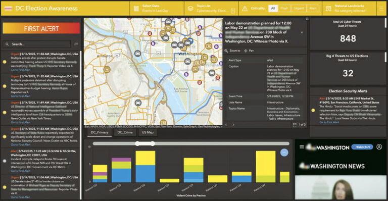
From public disorder to weather threats, real-time risk detection is critical. #ArcGISVelocity integrates Dataminr alerts into live dashboards—giving teams the insight they need to act fast and stay ahead. Read the article for details: ow.ly/28fe50WZIIN

Interested in real-time data monitoring? Discover how to utilize Arcade Track Functions in #ArcGISVelocity, a real-time app for #ArcGISOnline, for effective stream flow monitoring. Dive into our latest blog to learn more: esri.social/56vs50TqkJ7
Join us at #FedGIS2025 to learn about advancements in #ArcGISVelocity, an extension for #ArcGISOnline, that brings powerful real-time capabilities for ingesting, analyzing, and disseminating critical information. Check out the real-time GIS sessions: ow.ly/pLKF50UST3q


📅 Heading to #EsriUC2025 in San Diego, July 14-18? Visit the #ArcGISVelocity and ArcGIS GeoEvent Server kiosks or join a session to get the latest on real-time #GIS. For details on each session and what to expect, check out this blog ➡️ ow.ly/Lcqr30sNZw2


Heading to #EsriUC2025 in San Diego, July 14-18? Visit the #ArcGISVelocity and #ArcGISGeoEvent kiosks or join a session to get the latest on real-time GIS. For details on each session and what to expect, check out our blog! Read more ➡️ ow.ly/HZWk50WfCRE


Find out what’s new in #ArcGISVelocity. We have several exciting new capabilities and enhancements in this release! ☑️New output types (Amazon SNS, Amazon SQS, AWS IoT) ☑️New Create Range Fans tool ☑️And more! Explore blog: esri.social/eTst50OQXjW

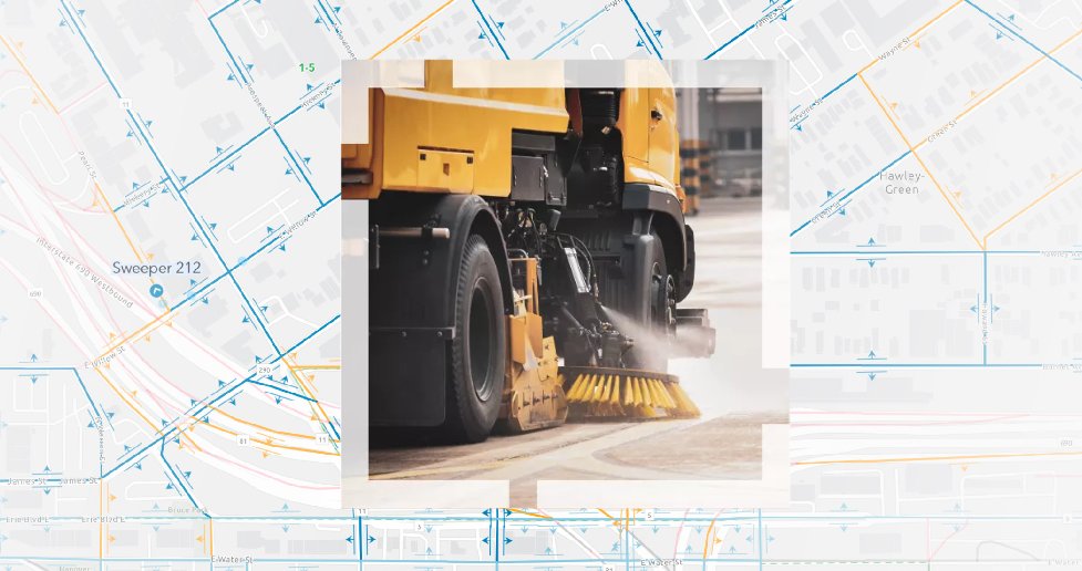
Clean streets are more than just beautiful—they're essential for safety and sustainability! Discover Esri’s Street Sweeping Operations solution to improve your community's appeal & safety. Learn about #ArcGISVelocity, a real-time app for #ArcGISOnline: esri.social/TwEw50Trp1A

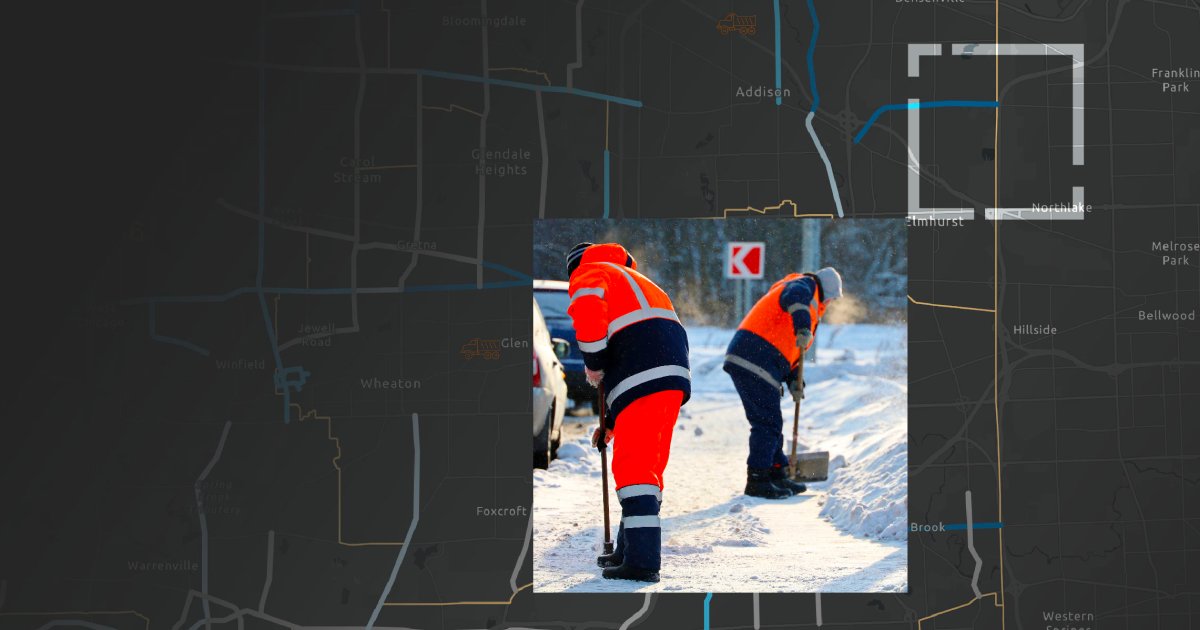
City of Syracuse is tracking snowplows during winter events with a GIS-powered solution called Winter Weather Operations. Using #ArcGISVelocity on #ArcGISOnline, it improves road safety, reduces costs, and provides real-time snow removal info: ow.ly/w0Ut50UICwW

The new @Samsara feed type in #ArcGISVelocity streamlines connecting to your vehicle telematics into #ArcGISOnline. This powerful integration helps enhance public services, boost driver operational efficiency, and improve community safety. Read the story: esri.social/zT5T50TzlO8

Enhance street-sweeping operations with #ArcGIS Solutions and #ArcGISVelocity, an app for #ArcGISOnline! Streamline planning of sweeping schedules, centralize sweeper info, monitor real-time activity, and share schedules with the public. Learn more: esri.social/RIwl50SSsyc
Check out #ArcGISVelocity, the SaaS IoT app for #ArcGISOnline! Explore our top 3 insights in real-time GIS from the Esri UC. From seamless Esri partner data integration to innovative solution templates, dive into our key highlights. Learn more: esri.social/weMB50T87qv

Organizations implementing real-time solutions face an increasing challenge in collecting, analyzing, and storing growing amounts of real-time and historical data. Explore data retention in #ArcGISVelocity, an extension for #ArcGISOnline. Learn more: ow.ly/lcj750UY1pp


Clean streets are more than just beautiful—they're essential for safety and sustainability! Discover Esri’s Street Sweeping Operations solution to improve your community's appeal & safety. Learn about #ArcGISVelocity, a real-time app for #ArcGISOnline: ow.ly/lnSB50Tufj5

Organizations implementing real-time solutions face an increasing challenge in collecting, analyzing, and storing growing amounts of real-time and historical data. Explore data retention in #ArcGISVelocity, an extension for #ArcGISOnline. Learn more: ow.ly/kAzM50UZxWw

Discover the top three takeaways in real-time GIS from the 2024 #Esri UC! From Esri partner data integration to new solution templates, dive into our biggest takeaways from an amazing conference. Learn more ➡️ esri.social/QbhK50T8VX2 #ArcGIS #ArcGISVelocity

#Python でリアルタイム解析を監視!開発者必見の #ArcGISVelocity × #ArcGISNotebooks 活用術🔍 |Esri Community Blog| [community.esri.com/t5/documents/A…] #開発 #ArcGIS #リアルタイム解析
![ESRIJapan's tweet image. #Python でリアルタイム解析を監視!開発者必見の #ArcGISVelocity × #ArcGISNotebooks 活用術🔍
|Esri Community Blog| [community.esri.com/t5/documents/A…]
#開発 #ArcGIS #リアルタイム解析](https://pbs.twimg.com/media/F12x8PbagAAM7XT.png)
ArcGIS Velocity から Microsoft Teams への通知方法をご紹介! #ArcGIS #ArcgisVelocity #MicrosoftTeams #AdaptiveCard blog.esrij.com/?p=68000
ArcGIS Velocity から Microsoft Teams への通知方法をご紹介! |Esri Community Blog|[ community.esri.com/t5/a/a/ta-p/16… ] #ArcGIS #ArcgisVelocity #MicrosoftTeams #AdaptiveCard #地図 #GIS #サーバー
From public disorder to weather threats, real-time risk detection is critical. #ArcGISVelocity integrates #EsriPartner Dataminr alerts into live dashboards—giving teams the insight they need to act fast and stay ahead. Read the article 👇 ow.ly/JyYu50X12W3
From public disorder to weather threats, real-time risk detection is critical. #ArcGISVelocity integrates Dataminr alerts into live dashboards—giving teams the insight they need to act fast and stay ahead. Read the article for details: ow.ly/28fe50WZIIN

Organizations can now seamlessly stream AVL data from PreCise MRM directly into the #ArcGIS system with #ArcGISVelocity —unlocking real-time dashboards, alerts, and analytics for smarter, faster decisions. See how this integration transforms operations: ow.ly/ew4O50WVoPa
Stay ahead of winter weather with #ArcGIS! The Winter Weather Operations solution, powered by #ArcGISVelocity, helps develop response plans, monitor operations in real-time, share status updates, and track vehicle locations. Explore more: ow.ly/Ztmm50WPPwI
Real-time GIS took center stage at #EsriUC2025! Highlights include San Francisco Airport's use of #ArcGISVelocity to streamline runway ops, the new Transit On-Time Performance Solution, and Velocity announced a Beta for #ArcGISEnterprise. Learn more ➡️ ow.ly/qFyn50WCkwj
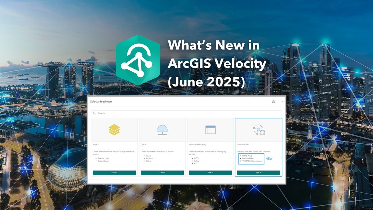
June 2025 update of #ArcGISVelocity introduces exciting new features and enhancements! A new integration with @trimble for data-driven work order automation, several new data provider feeds, and analytic tools. Get more details: ow.ly/18AS50WkuhJ
📅 Heading to #EsriUC2025 in San Diego, July 14-18? Visit the #ArcGISVelocity and ArcGIS GeoEvent Server kiosks or join a session to get the latest on real-time #GIS. For details on each session and what to expect, check out this blog ➡️ ow.ly/Lcqr30sNZw2
📅 Heading to #EsriUC2025 in San Diego, July 14-18? Visit the #ArcGISVelocity and #ArcGISGeoEventServer kiosks or join a session to get the latest on real-time GIS. For details on each session and what to expect, check out this blog ➡️ ow.ly/mNTz50WhLls

Heading to #EsriUC2025 in San Diego, July 14-18? Visit the #ArcGISVelocity and #ArcGISGeoEvent kiosks or join a session to get the latest on real-time GIS. For details on each session and what to expect, check out our blog! Read more ➡️ ow.ly/HZWk50WfCRE
The Search and Rescue Common Operating Platform (SARCOP) enhanced hurricane safety during Hurricanes Milton and Helene. #ArcGISVelocity was critical to providing a shared operational view for multiple agencies, improving coordination & resource allocation. ow.ly/Nr5Y30sL2nb

Last week at the Esri Developer & Technology Summit, Baron Weather delivered an impressive keynote presentation. They showcased a demo using #ArcGISVelocity to connect to real-time wind gust data, filter high winds, and send alerts. Learn more: ow.ly/FqG750VnBFS


The Search and Rescue Common Operating Platform (SARCOP) enhanced hurricane safety during Hurricanes Milton and Helene. #ArcGISVelocity was critical to providing a shared operational view for multiple agencies, improving coordination & resource allocation. ow.ly/YOVW30sKUgG

Last week at the Esri Developer & Technology Summit, Baron Weather delivered an impressive keynote presentation. They showcased a demo using #ArcGISVelocity to connect to real-time wind gust data, filter high winds, and send alerts. Learn more: ow.ly/9xGK50VkORt


At the #Esri Developer & Technology Summit, Baron #Weather delivered an impressive keynote presentation. They showcased a demo using #ArcGISVelocity to connect to #RealTime #wind gust data, filter high winds, & send alerts ow.ly/h6BZ50Vlo95 #GIS #ArcGIS #GPN #APWA
mediaspace.esri.com
Reimagining Your Weather Data for GIS Business Applications
The February 2025 update of #ArcGISVelocity will introduce new features and enhancements! Explore new real-time flight tracking with @FlightAware, hyperlocal weather data from @BaronWeather, and Microsoft Teams & Slack outputs for alerts. Learn more: ow.ly/iLta30sKJly

The February 2025 update of #ArcGISVelocity will introduce new features and enhancements! Explore new real-time flight tracking with @FlightAware, hyperlocal weather data from @BaronWeather, and Microsoft Teams & Slack outputs for alerts. Learn more: ow.ly/z5u150Vc0sa


🐑 From real-time data to real-time action: Discover how @NebraskaDOT is using #ArcGISVelocity and @Vectronics animal collars to transform Bighorn Sheep conservation. Read the case study here: ow.ly/qfAb50V5IUZ

From public disorder to weather threats, real-time risk detection is critical. #ArcGISVelocity integrates #EsriPartner Dataminr alerts into live dashboards—giving teams the insight they need to act fast and stay ahead. Read the article 👇 ow.ly/JyYu50X12W3
Interested in real-time data monitoring? Discover how to utilize Arcade Track Functions in #ArcGISVelocity, a real-time app for #ArcGISOnline, for effective stream flow monitoring. Dive into our latest blog to learn more: esri.social/56vs50TqkJ7
Heading to #EsriUC2025 in San Diego, July 14-18? Visit the #ArcGISVelocity and #ArcGISGeoEvent kiosks or join a session to get the latest on real-time GIS. For details on each session and what to expect, check out our blog! Read more ➡️ ow.ly/HZWk50WfCRE
The new @Samsara feed type in #ArcGISVelocity streamlines connecting to your vehicle telematics into #ArcGISOnline. This powerful integration helps enhance public services, boost driver operational efficiency, and improve community safety. Read the story: esri.social/zT5T50TzlO8
Join us at #FedGIS2025 to learn about advancements in #ArcGISVelocity, an extension for #ArcGISOnline, that brings powerful real-time capabilities for ingesting, analyzing, and disseminating critical information. Check out the real-time GIS sessions: ow.ly/pLKF50UST3q
#Python でリアルタイム解析を監視!開発者必見の #ArcGISVelocity × #ArcGISNotebooks 活用術🔍 |Esri Community Blog| [community.esri.com/t5/documents/A…] #開発 #ArcGIS #リアルタイム解析
📅 Heading to #EsriUC2025 in San Diego, July 14-18? Visit the #ArcGISVelocity and ArcGIS GeoEvent Server kiosks or join a session to get the latest on real-time #GIS. For details on each session and what to expect, check out this blog ➡️ ow.ly/Lcqr30sNZw2
From public disorder to weather threats, real-time risk detection is critical. #ArcGISVelocity integrates Dataminr alerts into live dashboards—giving teams the insight they need to act fast and stay ahead. Read the article for details: ow.ly/28fe50WZIIN
Enhance street-sweeping operations with #ArcGIS Solutions and #ArcGISVelocity, an app for #ArcGISOnline! Streamline planning of sweeping schedules, centralize sweeper info, monitor real-time activity, and share schedules with the public. Learn more: esri.social/RIwl50SSsyc
#ArcGISVelocity, a SaaS IoT app for #ArcGISOnline, supports real-time data from trusted Esri partners or your own systems. Sensor data, weather feeds, incidents, social media streams—Velocity handles it all. Explore partners and data providers: esri.social/uoTK50Sis0H

Clean streets are more than just beautiful—they're essential for safety and sustainability! Discover Esri’s Street Sweeping Operations solution to improve your community's appeal & safety. Learn about #ArcGISVelocity, a real-time app for #ArcGISOnline: esri.social/TwEw50Trp1A
City of Syracuse is tracking snowplows during winter events with a GIS-powered solution called Winter Weather Operations. Using #ArcGISVelocity on #ArcGISOnline, it improves road safety, reduces costs, and provides real-time snow removal info: ow.ly/w0Ut50UICwW
ArcGIS Velocity から Microsoft Teams への通知方法をご紹介! |Esri Community Blog|[ community.esri.com/t5/a/a/ta-p/16… ] #ArcGIS #ArcgisVelocity #MicrosoftTeams #AdaptiveCard #地図 #GIS #サーバー
June 2025 update of #ArcGISVelocity introduces exciting new features and enhancements! A new integration with @trimble for data-driven work order automation, several new data provider feeds, and analytic tools. Get more details: ow.ly/18AS50WkuhJ
Discover the top three takeaways in real-time GIS from the 2024 #Esri UC! From Esri partner data integration to new solution templates, dive into our biggest takeaways from an amazing conference. Learn more ➡️ esri.social/QbhK50T8VX2 #ArcGIS #ArcGISVelocity
Check out #ArcGISVelocity, the SaaS IoT app for #ArcGISOnline! Explore our top 3 insights in real-time GIS from the Esri UC. From seamless Esri partner data integration to innovative solution templates, dive into our key highlights. Learn more: esri.social/weMB50T87qv
Get ready for #EsriUC2024! Explore a focused agenda highlighting real-time visualization and analytics activities. Stop by the expo to learn about #ArcGISVelocity, a cloud-native add-on for #ArcGIS Online. View the agenda: esri.social/zJN650Sxilw

Detect and manage threats in real-time with #Esri's Watch Center. Improve incident response and info sharing using #ArcGISVelocity, an #ArcGISOnline app. Get started quickly with a pre-configured solution: esri.social/gRTJ50TG0vO
🐑 From real-time data to real-time action: Discover how @NebraskaDOT is using #ArcGISVelocity, an extension for #ArcGISOnline, and @Vectronics animal collars to transform Bighorn Sheep conservation. Read the case study here: ow.ly/2Fep50UY1qc

Organizations implementing real-time solutions face an increasing challenge in collecting, analyzing, and storing growing amounts of real-time and historical data. Explore data retention in #ArcGISVelocity, an extension for #ArcGISOnline. Learn more: ow.ly/lcj750UY1pp
Something went wrong.
Something went wrong.
United States Trends
- 1. Lakers 50K posts
- 2. Dillon Brooks 7,002 posts
- 3. Bron 24.8K posts
- 4. Kanata 10.2K posts
- 5. Giants 85.8K posts
- 6. #WWERaw 71.3K posts
- 7. Dart 36.2K posts
- 8. Patriots 131K posts
- 9. Suns 19.1K posts
- 10. Collin Gillespie 2,042 posts
- 11. #AvatarFireAndAsh 3,024 posts
- 12. Drake Maye 24.4K posts
- 13. STEAK 10.5K posts
- 14. Ryan Nembhard 4,222 posts
- 15. Diaz 34.1K posts
- 16. Devin Williams 7,738 posts
- 17. James Cameron 4,650 posts
- 18. Gunther 15.3K posts
- 19. Pats 16.3K posts
- 20. Devin Booker 2,636 posts