#gismapping search results

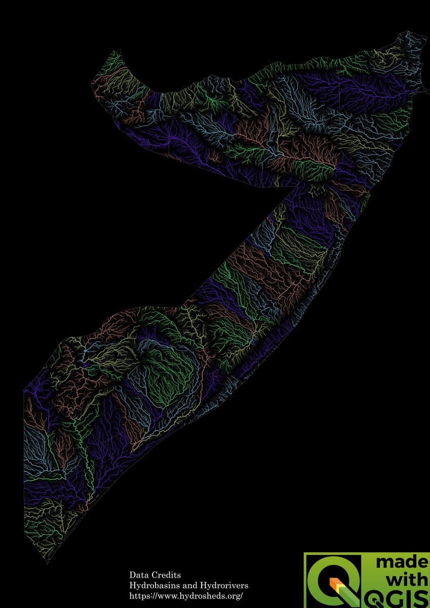
I love artistic river maps so I made one using QGIS, This is 𝐒𝐨𝐦𝐚𝐥𝐢𝐚 𝐂𝐨𝐥𝐨𝐫𝐢𝐳𝐞𝐝 𝐫𝐢𝐯𝐞𝐫 𝐁𝐚𝐬𝐢𝐧 𝐦𝐚𝐩 and I think it looks beautiful. #qgis #gismapping #hydrology #rivers #somalia

Primary school maps sparked a curiosity… Today, I’m turning that curiosity into meaningful geospatial insights! 🌿🛰️ #GISMapping #GrowthJourney


I was inspired by John Nelson 5 minute map and I decided to recreate it, using this walkthrough esri.com/arcgis-blog/pr… It was great to try out some spectacular blend modes. #GIS #gismapping #geospatial #arcgispro

आज वन भूमि हस्तान्तरण बैठक हुई सम्पन्न। PWD & PMGSY के प्रकरणों की समीक्षा कर अधिकारियों को दिशा-निर्देश दिये गए। भूमि अधिग्रहण प्रस्तावों का GIS मैपिंग कर तहसील एवं वन विभाग को सुविधा सुनिश्चित की जाएगी। 🌳🏗️ #वनभूमि #टिहरीगढ़वाल #GISMapping @ukcmo @DIPR_UK @TehriDIPR


Powering Data with Precision: How GIS Mapping Transforms Field Data Collection. 🌍📊 #GISMapping #DataCollection #SocialImpact #FieldResearch #OutlineIndia

Do you offer #BIM or #GISmapping and #monitoringsolutions for Railway & Metro projects? 📢 Free nominations open for the 7th Rail Analysis Innovation & Excellence Summit 2026 📍 Hotel Le Méridien, New Delhi | 📅 30th January 2026 👉 conference.railanalysis.com/nomination.html #RAIES2026

Did you know poverty levels vary widely across Nigeria? This choropleth map visualizes poverty distribution across Nigeria using data from the NBS – Nigerian Living Standard Survey (2018/2019).What do you think about these figures. #GISMapping #QGIS #NigeriaStats #ChoroplethMaps


ArcGIS Extensions can greatly improve your mapping capabilities. Here are some of Esri's most popular ArcGIS Extensions that will make a big impact on your work👇 hubs.li/Q01QC6WF0 #ArcGISExtensions #GISmapping


HYBRID TALK: Problems in Isaurian Topography 🗣 Prof Hugh Elton (Trent University) 📆Tuesday, 13th May 2025 ⏰15:30 - 17:30 (London BST) 17:30 - 19:30 (Ankara UTC+3) 📍BIAA, Atatürk Bulvarı 154/1 and ONLINE ℹ️ REGISTER at biaa.ac.uk/events/problem… #settlementpatterns #GISMapping


सेवा हमी पंधरवड्यात शेतकऱ्यांना केंद्रस्थानी ठेवून पाणंद रस्त्याचे #GISMapping चे काम सुरु.... आपणही या सेवा हमी पंधरवड्यात सहभागी व्हा..! रस्त्याबाबतचे वाद मिटवून घ्या..! #छत्रपतीशिवाजीमहाराजस्वअभियान #सेवापंधरवडा #पुणे


Showcase your mapping skills. Chance to create innovative #maps and win the attractive gift hampers. #GISmapping #ectadnepal

सेवा पंधवडा उपक्रमाच्या माध्यमातून पाणंद रस्त्यांचे #GISMapping करण्यात येणार. शेतकऱ्यांमधील पाणंद रस्त्याबाबतचे वाद संपुष्टात येवून त्यांच्या जीवनात सुलभता येणार आहे-सेवा पंधरवडा कार्यक्रमात @Dev_Fadnavis #सेवापंधरवडा #छत्रपतीशिवाजीमहाराजस्वअभियान

With the GIS Base Map, advanced technology is shaping a smarter and more efficient city, paving the way for sustainable growth and better planning. Let’s build a brighter tomorrow! #SmartCityAligarh #GISMapping #UrbanPlanning #FutureReady #smartcitiesmission #smartcities #ascl


World Meteorological day - 23rd March 2023 All the people who work outside in the cold & heat #collaboration #teamwork #gismapping #landsurveying #geodesy #geography #meteorology #weather #ios #education #training #HSE #software #construction #mapping #gnss #infrastructure

Yesterday on 14th May, 2024, one day District Level Training for Contractor on GIS MAPPING was conducted under the PHE Division Dhubri. #GISMapping #JJMAssam #JalJeevanMission #HarGharJal #assam @jaljeevan_ @dcofficedhubri


Visit AllTerra at Booth 200 at the 2023 AASHTO & GIS for Transportation Symposium at the Oklahoma City Convention Center to see the Trimble MX9 Mobile Mapper and GeoCue's TruView LiDAR mapping hardware. #2023gist #gis #gismapping #transportation #AllTerraCentral #MX9 #Trimble


Dive into the world of GIS mapping with the latest episode of VOS. Discover how technology empowers law enforcement to keep our communities safe. Full episode: bit.ly/3DU8F3E and Spotify: bit.ly/3WcSchu #GISMapping #CommunitySafety

#LAMASUS_EU wants to put a *spotlight* on #LAMASUS_early_career_researchers Meet Evelina Sandström, a researcher from @VUamsterdam . As an expert in #GISmapping and programming tools, Evelina investigates the consequences of policy on #landuse. #earlycareerresearchers


Unlock the power of GIS Mapping in Encinitas! 🗺️ Explore our Development Planning webpage for easy access to tools like Engineering Plan Index, E-Zoning, Historical Imagery Viewer, Land Records, & more! 🌳 📲Check it out at the link in our bio! #GISMapping #CityServices


🌍 Looking to make smarter, data-driven decisions? Our GIS Mapping and Drone Surveying services combine cutting-edge technology with geographic intelligence to help you visualize, analyze, and act with confidence. 📞96756 94400 🔗 epitomegs.com/our-services/g… #GISMapping #EpitomeGIS

To this end, our work with the youth in Narok County (Loita Community Forest mapping) and in Turkana County (community land registration initiatives) are testament to our commitment to centering the youth in Kenya’s land rights conversations. #YouthForLandJustice #GISMapping


A Geographical Analysis of Non-Communicable Diseases Among Tribal Population of North Maharashtra Read here: cwejournal.org/vol3no3/pa-geo… #GISmapping #Healthcareaccessibility #Noncommunicablediseases #Publichealthinterventions #Socioeconomicdeterminants #Tribalpopulations


RJN’s Marco and Reagan had a great time attending the Illinois GIS Association (ILGISA) Conference, connecting with GIS professionals from across the state to explore how mapping, modeling, and data visualization are shaping smarter infrastructure decisions. 🗺️💧 #GISMapping


Two Italies on One Map 🇮🇹 Read more: linkedin.com/feed/update/ur… #GeoICT #ItalyIncome #GISMapping #EconomicData


Explore how GIS mapping is transforming industries through precision, insight, and innovation! junomaps.com #JunoMaps #Smartsiteplan #GISMapping #GeospatialIntelligence
आज वन भूमि हस्तान्तरण बैठक हुई सम्पन्न। PWD & PMGSY के प्रकरणों की समीक्षा कर अधिकारियों को दिशा-निर्देश दिये गए। भूमि अधिग्रहण प्रस्तावों का GIS मैपिंग कर तहसील एवं वन विभाग को सुविधा सुनिश्चित की जाएगी। 🌳🏗️ #वनभूमि #टिहरीगढ़वाल #GISMapping @ukcmo @DIPR_UK @TehriDIPR
Do you offer #BIM or #GISmapping and #monitoringsolutions for Railway & Metro projects? 📢 Free nominations open for the 7th Rail Analysis Innovation & Excellence Summit 2026 📍 Hotel Le Méridien, New Delhi | 📅 30th January 2026 👉 conference.railanalysis.com/nomination.html #RAIES2026
सेवा हमी पंधरवड्यात शेतकऱ्यांना केंद्रस्थानी ठेवून पाणंद रस्त्याचे #GISMapping चे काम सुरु.... आपणही या सेवा हमी पंधरवड्यात सहभागी व्हा..! रस्त्याबाबतचे वाद मिटवून घ्या..! #छत्रपतीशिवाजीमहाराजस्वअभियान #सेवापंधरवडा #पुणे


I love artistic river maps so I made one using QGIS, This is 𝐒𝐨𝐦𝐚𝐥𝐢𝐚 𝐂𝐨𝐥𝐨𝐫𝐢𝐳𝐞𝐝 𝐫𝐢𝐯𝐞𝐫 𝐁𝐚𝐬𝐢𝐧 𝐦𝐚𝐩 and I think it looks beautiful. #qgis #gismapping #hydrology #rivers #somalia

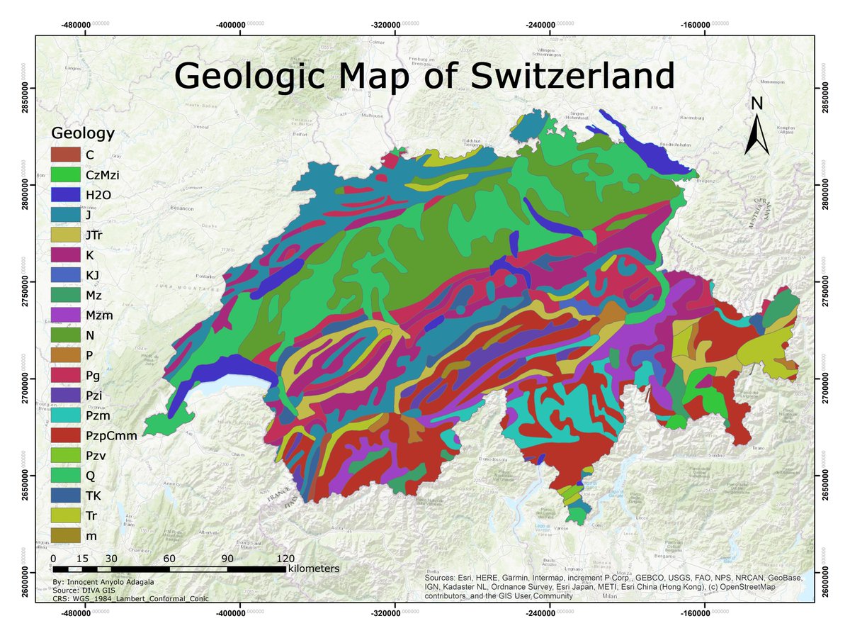
Geology is the study of the earth. Understanding earth history helps foresee how past events affect the future. Hazard areas can be identified and avoided. Below, a map showing Switzerland's geology. Can you identify the rocks shown?🙂 #geology #gismapping #cartography #spatial
आज वन भूमि हस्तान्तरण बैठक हुई सम्पन्न। PWD & PMGSY के प्रकरणों की समीक्षा कर अधिकारियों को दिशा-निर्देश दिये गए। भूमि अधिग्रहण प्रस्तावों का GIS मैपिंग कर तहसील एवं वन विभाग को सुविधा सुनिश्चित की जाएगी। 🌳🏗️ #वनभूमि #टिहरीगढ़वाल #GISMapping @ukcmo @DIPR_UK @TehriDIPR

حياكم الله في جناح شركة تسعة أعشار ضمن فعالية اليوم العالمي لنظم المعلومات الجغرافية ٢٠٢٣ والمقام في جامعة الملك سعود You are kindly invited to drop by our booth at the GIS DAY 2023 which will be held on 15-16 of Nov 2023 at King Saud University #gisday2023 #gismapping #ksu


🌍 #دعوة_عامة تحت رعاية معالي رئيس جامعة الملك سعود يدعوكم قسم الجغرافيا بالتعاون مع الجمعية الجغرافية السعودية إلى فعالية: #اليوم_العالمي_لنظم_المعلومات_الجغرافية_2023 #GISDAY2023 📅 الاربعاء والخميس 15-2023/11/16م 📍 قاعة حمد الجاسر 🕘 8ص - 3م

I was inspired by John Nelson 5 minute map and I decided to recreate it, using this walkthrough esri.com/arcgis-blog/pr… It was great to try out some spectacular blend modes. #GIS #gismapping #geospatial #arcgispro
ArcGIS Extensions can greatly improve your mapping capabilities. Here are some of Esri's most popular ArcGIS Extensions that will make a big impact on your work👇 hubs.li/Q01QC6WF0 #ArcGISExtensions #GISmapping

We are excited to see the re-launch of GIS Jobs on our #jobboard platform. GIS Jobs has all the lasted #gisjobs across the UK, including #gismapping, #gisanalyst and #gisdeveloper roles.

Primary school maps sparked a curiosity… Today, I’m turning that curiosity into meaningful geospatial insights! 🌿🛰️ #GISMapping #GrowthJourney

ODCGIS are pleased to announce we have added XMAP, Geoxphere’s cloud-based GIS, as a cost-effective solution to the range of GIS platforms we recommend strengthening our unique GIS Managed Service. odc.co.uk/2023/05/10/odc… #gismapping #SocialHousing #geoxphere #odcgis
Unlock the power of GIS Mapping in Encinitas! 🗺️ Explore our Development Planning webpage for easy access to tools like Engineering Plan Index, E-Zoning, Historical Imagery Viewer, Land Records, & more! 🌳 📲Check it out at the link in our bio! #GISMapping #CityServices
Showcase your mapping skills. Chance to create innovative #maps and win the attractive gift hampers. #GISmapping #ectadnepal

Map structures and assets effortlessly with PowerAI’s GIS mapping and visualizations. Enhance your inspection capabilities with advanced technology. #GISMapping #EnergyTech

Yesterday on 14th May, 2024, one day District Level Training for Contractor on GIS MAPPING was conducted under the PHE Division Dhubri. #GISMapping #JJMAssam #JalJeevanMission #HarGharJal #assam @jaljeevan_ @dcofficedhubri

Here, the Geospatial Engineer was young, energetic and ambitious. Maybe the young part has changed a little, just a little. And I guess the reflector jackets fit better now 😆. But the energy and ambition has only increased! #GIS #GISMapping #Geospatial #GeospatialTechnology


Where's Waldo - or, um, Wessler?! If you're in Whiteland, IN and pass by a Wessler truck, give Brad and Trevor a wave! #GISmapping #manholeinspections #whereswaldo #whereswessler

World Meteorological day - 23rd March 2023 All the people who work outside in the cold & heat #collaboration #teamwork #gismapping #landsurveying #geodesy #geography #meteorology #weather #ios #education #training #HSE #software #construction #mapping #gnss #infrastructure
Visit AllTerra at Booth 200 at the 2023 AASHTO & GIS for Transportation Symposium at the Oklahoma City Convention Center to see the Trimble MX9 Mobile Mapper and GeoCue's TruView LiDAR mapping hardware. #2023gist #gis #gismapping #transportation #AllTerraCentral #MX9 #Trimble
#LAMASUS_EU wants to put a *spotlight* on #LAMASUS_early_career_researchers Meet Evelina Sandström, a researcher from @VUamsterdam . As an expert in #GISmapping and programming tools, Evelina investigates the consequences of policy on #landuse. #earlycareerresearchers
Apglos Survey Wizard has launched a new version for iOS, Bad Elf connects well with the iOS Version of Apglos Software #collaboration #gismapping #datalogger #geodesy #apple #ios #education #software #construction #mapping #landsurveying #gnss #infrastructure #ecobuilding

Did you know poverty levels vary widely across Nigeria? This choropleth map visualizes poverty distribution across Nigeria using data from the NBS – Nigerian Living Standard Survey (2018/2019).What do you think about these figures. #GISMapping #QGIS #NigeriaStats #ChoroplethMaps
Something went wrong.
Something went wrong.
United States Trends
- 1. Rosalina 32.8K posts
- 2. Bowser Jr 11.1K posts
- 3. $SENS $0.70 Senseonics CGM N/A
- 4. $LMT $450.50 Lockheed F-35 N/A
- 5. Jeffrey Epstein 70.2K posts
- 6. $APDN $0.20 Applied DNA N/A
- 7. #NASDAQ_MYNZ N/A
- 8. Michael Wolff 4,444 posts
- 9. H-1B 68.8K posts
- 10. Maxwell 65.9K posts
- 11. Jameis 5,199 posts
- 12. Mario Galaxy 78.8K posts
- 13. #wednesdaymotivation 5,183 posts
- 14. Benny Safdie 4,631 posts
- 15. Luigi 10K posts
- 16. Trump and Epstein 63K posts
- 17. House Democrats 35.7K posts
- 18. Virginia Giuffre 4,455 posts
- 19. #Wednesdayvibe 2,778 posts
- 20. Hump Day 18.4K posts