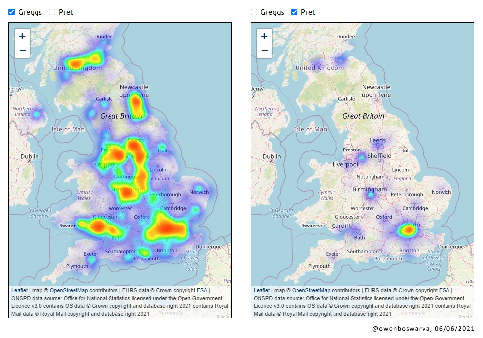
#leafletjs wyniki wyszukiwania


Yes! This happened during the #DataDive @DataKindSG - because if you cannot do it in Python, you do it in Javascript 😁 #leafletjs


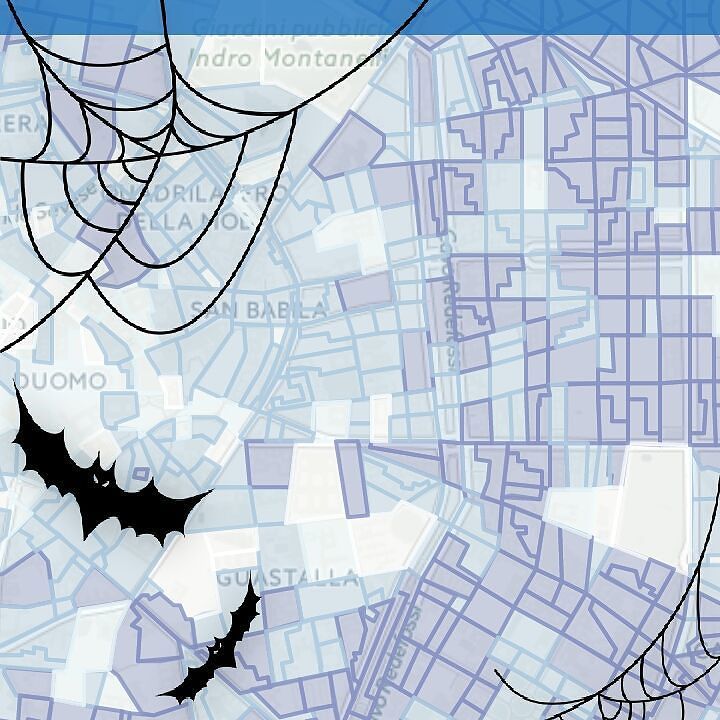
Adding interactive maps to the hero sections of both my Portfolio and Blog pages to provide geographic context for each project and article. Built with #LeafletJS and #JavaScript, styled with #CSS. Spatial data prepared in #QGIS.
Did you know that Maptiks integrates with #Esri, #Mango, #LeafletJS, #openlayers and #GoogleMaps. Whichever #gis map platform you use, we have you covered.


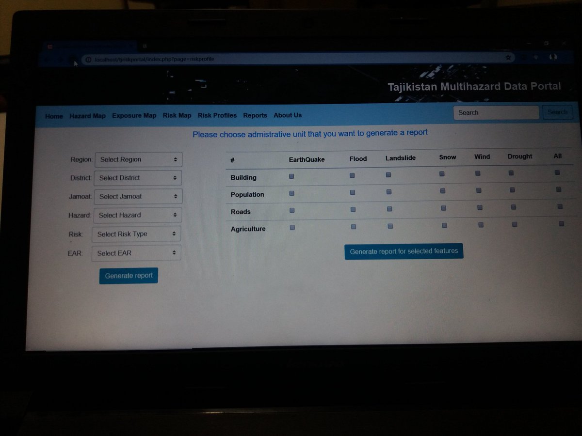
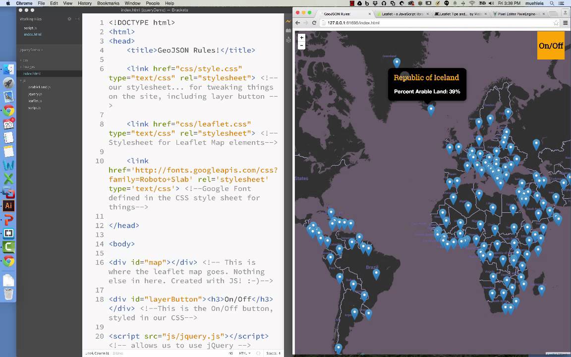
Day 34/100 Today I have done lots of things. I manage my codes, write some php code, learn how to apply extension on php using xampp, added #leafletjs in my project, design basic UI for the project. This is the UI. I build this today. #100DaysOfCode #php

Find out how to add a map to your website with these interactive examples on @CodePen. This one shows you how to change basemaps in #LeafletJS Check out all the examples: maptiler.link/3Tsd1UK #CodePen #WebDevelopment #MappingAPI


Use vector tiles in #LeafletJS with our plugin! Access our vector basemaps or any other vector layers in your MapTiler Cloud. You can switch languages without changing the basemap and much more! Check it out here: buff.ly/477Fp2q

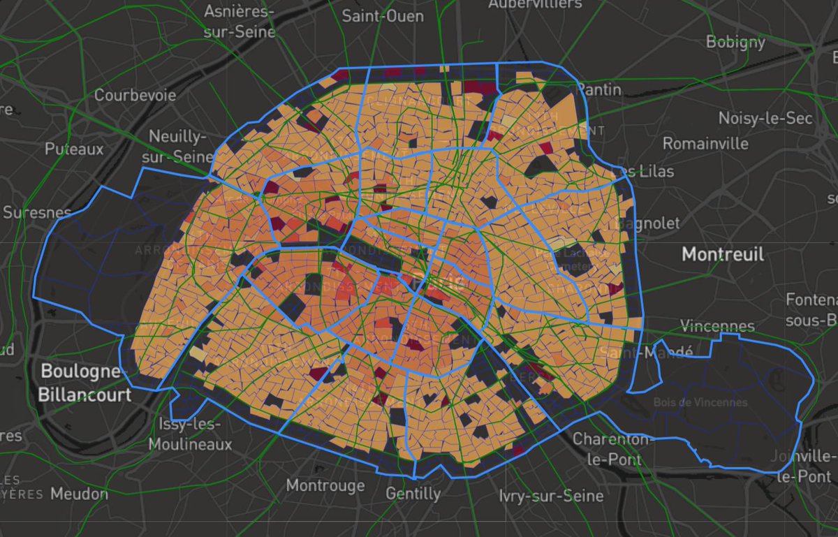
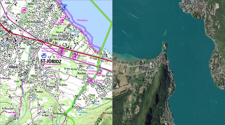
Looking to buy a place in Paris? This data visualization I built on my free time might come in handy :) check it out! marcanoma.com/dvf/index #leafletjs #angularjs #python #flask
A quick way to enhance the appearance of a raster tile layer in #LeafletJS is to tweak the #CSS image filters! I adjusted brightness, contrast, and saturation, and gave hue-rotate a slight shift toward the blues — it really improves the default #OpenStreetMap layer.

Probando #Windy API v4, también conocido como Windy #Leaflet Plugin, API de javascript basado en la tecnología de #LeafletJS

Happening now! Meetup with @dimfeld on the cool new #svelte library with #leaflet maps! Join us! Link in bio! #leafletjs #sveltejs #javascript #100DaysOfCode #codinglife #hackbuddy #hackbuddyorg #javascriptla

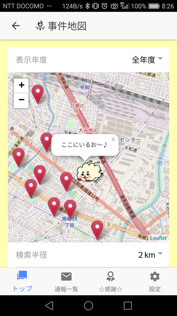
開発中の防犯アプリですが、Googleの地図を使うと利用料で数百万飛びそうだったので、急きょLeafletという無料の地図サービスに変更しました。 意外と手間かからず改造できて良かったです(汗) 現在地にキャラクターがいます(^_^;) #全国犯罪零 #ionic #LeafletJS

RT Tutor_Eduonix: We have started a fresh new #framework over on our #Youtube channel. Come learn #LeafletJS with us and create responsive #web #maps. goo.gl/HMJ5ut

Leaflet released: v1.8.0! geoobserver.wordpress.com/2022/04/19/lea… via @LeafletJS @RealIvanSanchez #leaflet #leafletJS #gistribe #fossgis #foss4g #DataViz #opensource #spatial #geospatial #mapping #gis #geo #geoObserver

NEW #ClojureX 2018 #SkillsCast: @COliverGodby - Lightning Talk: Reagent and #LeafletJS or "Fun with Maps" ⚡️ ed.gr/54m8 #Clojure #Data #Algorithms

Final PDF version of the Leaflet Cookbook is available at locatepress.com. If you purchased the preview, you can get the final by visiting the “My Books” link. Print version will be available soon… #leafletjs


Geoapify integrates with all major open-source mapping libraries. 🧠 What’s your go-to library, and why? #Geoapify #LeafletJS #MapLibre #OpenLayers
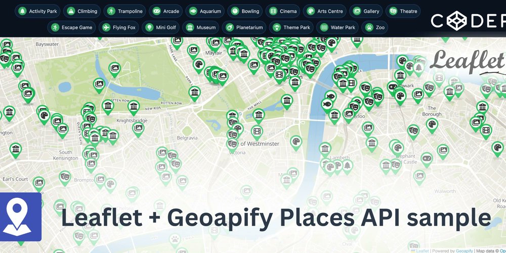
Building a “Find Nearby” feature? Here’s how to do it with Leaflet + Geoapify Places API — full tutorial 👇 dev.to/geoapify-maps-… #GIS #Geoapify #LeafletJS #WebDev #Coding #API #Geolocation

🚨 Je cherche un bénévole pour créer un outil de découpe de tuiles pour Leaflet 🗺️ Capable de gérer énormément de zones sans crash. #LeafletJS #Mapping #WebDev #GIS #JavaScript #OpenSource #Bénévole
⭐ Use Font Awesome with Marker Icons API! Thousands of icons, fully customizable in size, color, shadow & more for your maps. Just set: iconType=awesome&icon=star #mapdesign #webmaps #leafletjs #fontawesome #gisdev #maplibre 👉 geoapify.com/map-marker-ico…

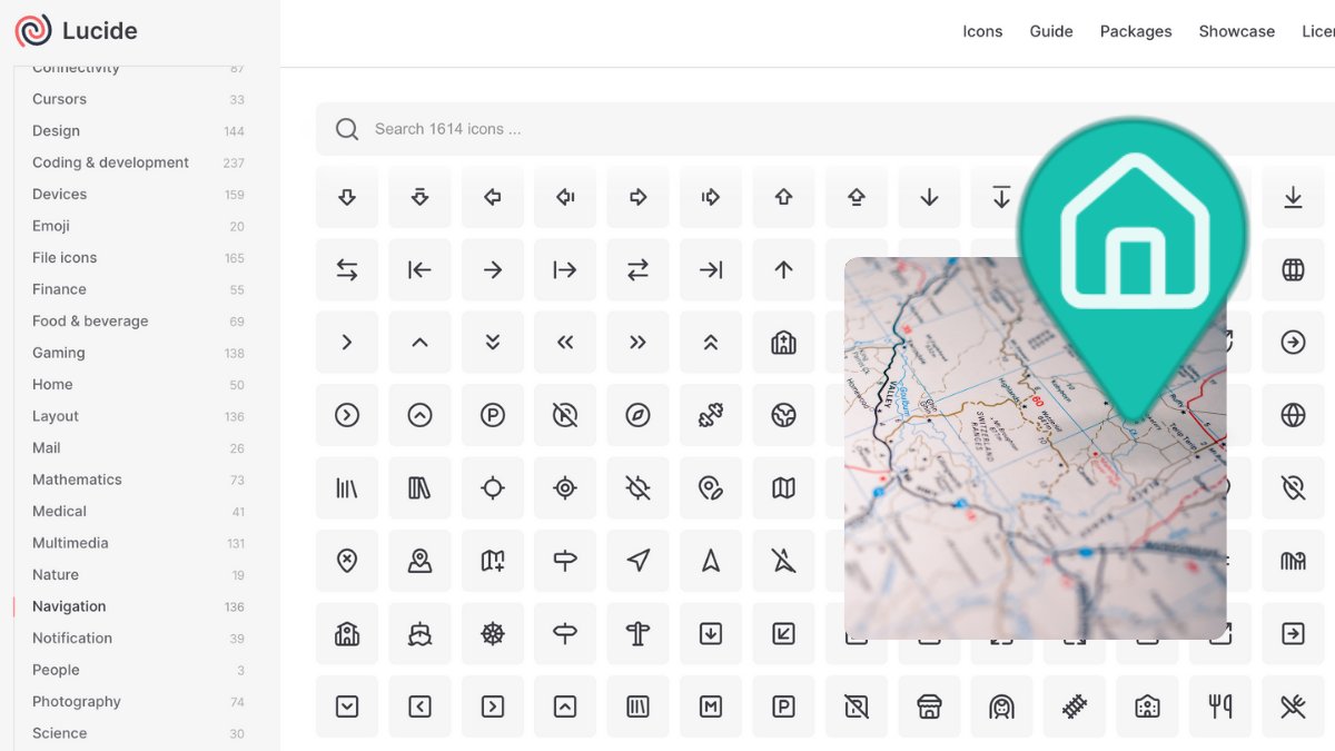
📍 Use sleek Lucide Icons in your custom map markers! Just set: iconType=lucide&icon=map-pin ✅ Up to 3000 icons/day for Free ✅ PNG download ready Try now → geoapify.com/map-marker-ico… #lucideicons #mapdesign #leafletjs #maplibre #gisdev #webmaps #frontenddev
🎯 Marker Icons API v2 = full control: size=80 → marker size contentSize=40 → icon size Example: ?icon=home&iconType=material&size=80&contentSize=40 👉 geoapify.com/map-marker-ico… #mapdesign #leafletjs #gisdev #maplibre #fontawesome #webmaps

🏠 Add Google’s Material Icons to your map markers! Just set: iconType=material&icon=home Free to download, PNG output, customizable size, color & more 🎨 👉 geoapify.com/map-marker-ico… #materialicons #leafletjs #maplibre #gisdev #webmaps #mapdesign

Want to add travel-time maps to your app? We published two minimal JS examples with @Geoapify’s Isoline API: 🗺️ Leaflet → github.com/geoapify/maps-… 🗺️ MapLibre → github.com/geoapify/maps-… #gis #javascript #leafletjs #maplibre #opensource

How to calculate a reachability map (aka isochrone / time-radius map) in JavaScript? 🧭 Use @Geoapify Isoline API 🗺️ Render with @LeafletJS or @MapLibre We’ve published two code samples to get you started: github.com/geoapify/maps-… #javascript #gis #leafletjs #maplibre #isoline
A quick way to enhance the appearance of a raster tile layer in #LeafletJS is to tweak the #CSS image filters! I adjusted brightness, contrast, and saturation, and gave hue-rotate a slight shift toward the blues — it really improves the default #OpenStreetMap layer.
🛠️ Want to build a time-radius map with @LeafletJS? This open-source example shows how to: ✅ Use @Geoapify’s Isoline API ✅ Send travel time/distance requests ✅ Draw polygons on the map Code 👉 github.com/geoapify/maps-… #javascript #leafletjs #gis #isoline #webdev
Custom map markers with: ✅ Font Awesome ✅ Material Icons ✅ Lucide Use them via Marker Icons API — free (3000/day), PNG-ready, works in Leaflet, Maplibre, Google Maps, and other. 👉 geoapify.com/map-marker-ico… #mapicons #gisdev #leafletjs #maplibre #webmaps #mapdesign

Want to add a time-radius map to @LeafletJS in minutes? This @Geoapify sample shows how to: ✅ Load isolines as GeoJSON ✅ Draw on map in 5 lines ✅ Add interactivity 👉 github.com/geoapify/maps-… #gis #leafletjs #javascript #isoline #GeoJSON
Adding interactive maps to the hero sections of both my Portfolio and Blog pages to provide geographic context for each project and article. Built with #LeafletJS and #JavaScript, styled with #CSS. Spatial data prepared in #QGIS.


isochrone driving maps #d3js + #leafletjs + @openstreetmap h/t @pkerpedjiev emptypipes.org/2016/03/04/iso…


Développeurs : accédez gratuitement aux #cartes et photos IGN dans #LeafletJS et #openlayers sans créer de compte ! geoservices.ign.fr/blog/2017/06/2…

Btw, if you were using #leafletjs but for the moment switched for something else, that you consider better lib for some reason. Could you give me few bullet options why alternative is better. #gis #geo #map #javascript #geospatial #datascience


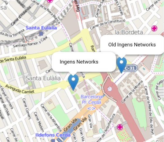
#Leafletjs vs Open Layers: Mapas Offline con #OpenStreetMap y #JavaScript ingens-networks.com/blog/post/2015… #AngularJS #Ion…

Check out my #leafletjs plugin that makes a 3D Globe Minimap! github.com/chriswhong/lea… #d3js @cartoDB

Yes! This happened during the #DataDive @DataKindSG - because if you cannot do it in Python, you do it in Javascript 😁 #leafletjs


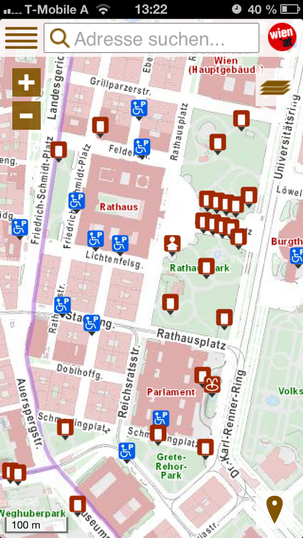
Erfolgreicher Launch des mobilen wien.at Stadtplan m.wien.gv.at/stadtplan/ #html5 #webapp #leafletjs

Interested in the mapping capabilities of #PowerBI and #LeafletJS? Join James Dales & Ric Howe at @MSPowerBI meetup to learn more!


Something went wrong.
Something went wrong.
United States Trends
- 1. Giants 62.7K posts
- 2. Giants 62.7K posts
- 3. #WWERaw 45.2K posts
- 4. Patriots 91.7K posts
- 5. Drake Maye 15.5K posts
- 6. Dart 26.2K posts
- 7. Diaz 32.5K posts
- 8. Gunther 9,648 posts
- 9. Younghoe Koo 3,076 posts
- 10. Devin Williams 4,475 posts
- 11. Marcus Jones 5,310 posts
- 12. Abdul Carter 6,964 posts
- 13. Kyle Williams 3,627 posts
- 14. Theo Johnson 1,709 posts
- 15. Joe Schoen 1,483 posts
- 16. #NYGvsNE 1,569 posts
- 17. #RawOnNetflix 1,489 posts
- 18. #MondayNightFootball 1,145 posts
- 19. Kafka 6,508 posts
- 20. Bron Breakker 5,737 posts