#mappromptmonday search results

Starting 2024 with #MapPromptMonday 🗺️Week 1 "New Tool or Map Type"🛠️ It was a good chance to try #Aerialod following @undertheraedar 's tutorials (thanks a lot😊) So here is the #map of a small piece of French Alps🇫🇷🏔️ #QGIS #3d #Sentinel2

#MapPromptMonday 🗺️ Week 2 "Travel Plans"🌍✈️🚢🛸Faroe islands! 🇫🇴 Maybe someday😊There is no trees or fields, just grass, rocks and endless vastness of the ocean⛰️🌊 #map #QGIS #traveling


#MapPromptMonday | Week 1: Region(s) Did you know...that 80% of greenland consists of an ice cap and glaciers? Data Source: lnkd.in/gsFdGQ5B Tools Used: ArcPro, Photoshop, Illustrator #gischat


#MapPromptMonday | Week 7: Bivariate Places where internet access needs to be most affordable is actually where it is least affordable in Los Angeles. #gischat

#MapPromptMonday 🗺️ Week 11. It's "Not my country", it's New Zealand🇳🇿. And the #EgmontNationalPark with the forest as an almost perfect circle around Mt Taranaki volcano. 🟢🏔️ #gis #qgis #landcover #map

#MapPromptMonday | Week 8:Grayscale/Black&White President Lincoln referred to this map often during his presidency, using it to understand how the progress of emancipation might affect Union troops on the ground. Top: My re-creation Bottom: The original map #gischat


This week’s #MapPromptMonday is about hexagons and now I have a reasonable excuse to repost to my blog on generating hexagon tessellation / grids with #RStats #RSpatial 🔗👉🏻 urbandatapalette.com/post/2021-08-t…

#MapPromptMonday 🗺️ Week 10 "#Bivariate". This #map shows solar☀️and wind💨potential of #Spain 🇪🇸💛❤️ I've made a similar map for 30 Day Map Challenge for France and it was interesting, so I decided to make another one🗺️😊 #QGIS #gis #dataviz #climate #GreenEnergy #España

#MapPromptMonday | Week 2: Hotspot Did you know...that the Coral Triangle is a hotspot for marine biodiversity? 6 out of 7 types of sea turtles live here! (Comment a Sea Turtle GIF if you love sea turtles!) #gischat

#MapPromptMonday 🗺️ Week 5 "Boundaries". Today's #map shows how beautiful shipping traffic outlines #Japan 🇯🇵 making visible boundaries of its land 🗾🌊🚢🛳️ #gis #QGIS

#MapPromptMonday | Week 3: Colorblind Friendly Did you know...there's an estimated 300 million people in the world with color vision deficiency? Right side is a traditional color palette, left side is a colorblind palette. #gischat

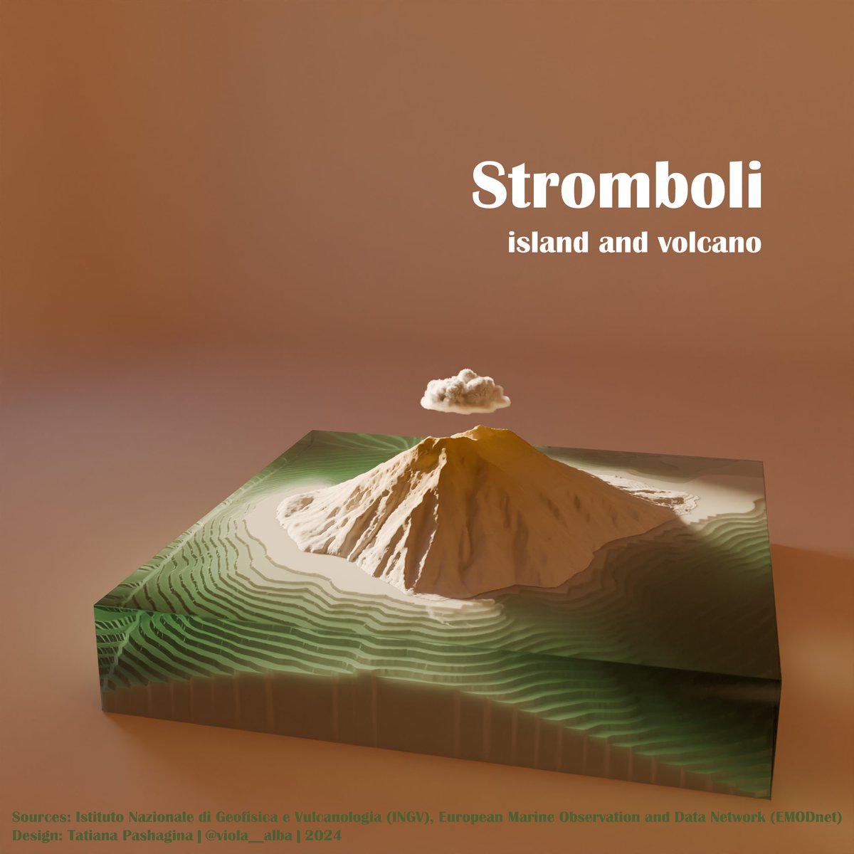
#MapPromptMonday 🗺️ Week 7 "Islands". A model of #Stromboli volcano island made of DEM ⛰️🌋and bathymetry 🌊🌊in #Blender Seems good enough for an experiment, I think😊 Looks like a vinyl record cover to me💿🎙️ #QGIS #gis #b3d #3dviz

#mappromptmonday Following another of @John_M_Nelson’s amazing tutorials for a tabletop forest density map. #forestry

#MapPromptMonday | Week 5: Flow Map In January 1992, a cargo ship in the North Pacific spilled nearly 29,000 rubber ducks and other bath toys into the ocean. Carried by ocean currents, bath toys made landfall all over the world. #gischat

#MapPromptMonday | Week 12: Inspired by... National Geographic maps are a constant inspiration to me because of its color gradients, intricate hill shades, rich textures, and gorgeous layouts. Every detail on every map is carefully crafted. Here's a map of jays! #gischat

#MapPromptMonday | Week 6: Climate/Weather The polar vortex is a large area of low pressure and cold air surrounding both of the Earth’s poles.During winter in the northern hemisphere, the polar vortex will expand, sending cold air southward with the jet stream. #gischat


#MapPromptMonday | Week 10: Favorite Animal It was really difficult to pick ONE favorite animal. My other picks: Penguins, dolphins, jays, pandas, cats, it's a different animal every day! Comment a GIF of YOUR favorite animal! #gischat


RT @MapsbyW: #MapPromptMonday | Week 1: Region(s) Did you know...that 80% of Greenland consists of an ice cap and glaciers?

The end of #MapPromptMonday is nigh. Here are your last prompts for December. Find more prompts on our website: github.com/MapPromptMonda…


This weeks belated #MapPromptMonday is Environment! Below is one of our products that show how agricultural land has been impacted by natural disasters like drought. Read the blog here: alcis.org/post/taliban-f…

#MapPromptMonday | Week 40 - 2024 | Death This map is for last week's theme. I actually had it done last week but have been a bit unmotivated to post it. Definitely been feeling some general burnout the last couple of months. I need a good recharge. #QGIS

Sorry for delay, but prompts for #MapPromptMonday in October are finally here! Learn more about Map Prompt Monday on our website: github.com/MapPromptMonda… Follow @MapPromptMonday to see participant maps!

#MapPromptMonday | Week 39 - 2024 | Voronoi Polygons I originally was going to do this using Kroger, but the scope was more work than I was willing to do at this time. It is interesting how these brands are disturbed across the East Coast. #QGIS

#MapPromptMonday I had an extraordinary time in Michigan this weekend seeing the Trojans go toe to toe with the defending national champions. Here is a geographic rationale for who to root for in the B1G conference - the closest team to anywhere in the county. @RedditCFB #ncaa

This weeks #MapPromptMonday prompt is 'Medicine'. In 2022, Afghanistan witnessed a devastating earthquake. Our team were quick to map the distances from affected compounds to health facilities, alongside how many and where the facilities were. Read on: alcis.org/earthquake

Prompts for #MapPromptMonday in September! Learn more about the prompts at our website: github.com/MapPromptMonda… Follow @MapPromptMonday to see participant maps!

Today's #MapPromptMonday prompt is 'Movement'! Back in 2020, our team mapped the migration routes of the nomadic Kuchi tribe. To read the full story, check out our storymap here: storymaps.arcgis.com/stories/faf39b…

#mappromptmonday “Subterranean”. These are the actual *underground* sections of the London Underground. #tfl #transport

#MapPromptMonday | Week 32 - 2024 | Network Finally finished up this map that I should have posted last week. This highway system is my "go-to" when it comes to traveling. I love a good roadtrip! #QGIS

#MapPromptMonday | Week 33 - 2024 | Energy Inspired by a YouTube video from @MikeCompany17, I thought this might make a neat map. This week's theme is energy, so a map of gas stations with similar names also seemed reasonable. #QGIS

This weeks #MapPromptMonday theme is 'Networks'. Back last year, we created a StoryMap surrounding the illicit charcoal trade in Uganda. The map below illustrates our research into the trade network. Read our StoryMap here: storymaps.arcgis.com/stories/30adf1…

#MapPromptMonday Network. So much data whipping around the world at the bottom of the sea. These are the biggest international submarine communications cables. #data #bigdata #titanic

Prompts for #MapPromptMonday in August! Learn more about the prompts at our website: github.com/MapPromptMonda… Follow @MapPromptMonday to see participant maps!

#MapPromptMonday Every named place in T-Swiz’s “London Boy” (2019). And an extra one with Killatrav from this year. #taylorswift

#MapPromptMonday | Week 31 - 2024 | Music I still remember the first time I heard one of their songs on the radio 📻 and the DJ said the band name, so confusing.🫤 When people ask where I’m from, I usually say “Detroit” to avoid the same confusion. #qgis #linkinpark

This weeks #MapPromptMonday's prompt is Heat/Hotspot Maps! The map below shows the coastline of Timor-Leste, identifying areas that have been impacted by rising sea levels. Explore our StoryMap for more info: storymaps.arcgis.com/stories/0a0ffb…

#MapPromptMonday 🗺️ Week 5 "Boundaries". Today's #map shows how beautiful shipping traffic outlines #Japan 🇯🇵 making visible boundaries of its land 🗾🌊🚢🛳️ #gis #QGIS
#MapPromptMonday | Week 24 - 2024 | Literature 😆 I'm not into reading literature, so I did my best with this theme. While not proud of it, I have read this book. Sometimes we make sacrifices so that those that we love are happy. #qgis

#MapPromptMonday 🗺️ Week 2 "Travel Plans"🌍✈️🚢🛸Faroe islands! 🇫🇴 Maybe someday😊There is no trees or fields, just grass, rocks and endless vastness of the ocean⛰️🌊 #map #QGIS #traveling
Starting 2024 with #MapPromptMonday 🗺️Week 1 "New Tool or Map Type"🛠️ It was a good chance to try #Aerialod following @undertheraedar 's tutorials (thanks a lot😊) So here is the #map of a small piece of French Alps🇫🇷🏔️ #QGIS #3d #Sentinel2
#MapPromptMonday 🗺️ Week 11. It's "Not my country", it's New Zealand🇳🇿. And the #EgmontNationalPark with the forest as an almost perfect circle around Mt Taranaki volcano. 🟢🏔️ #gis #qgis #landcover #map
#MapPromptMonday 🗺️ Week 10 "#Bivariate". This #map shows solar☀️and wind💨potential of #Spain 🇪🇸💛❤️ I've made a similar map for 30 Day Map Challenge for France and it was interesting, so I decided to make another one🗺️😊 #QGIS #gis #dataviz #climate #GreenEnergy #España
#MapPromptMonday 🗺️ Week 7 "Islands". A model of #Stromboli volcano island made of DEM ⛰️🌋and bathymetry 🌊🌊in #Blender Seems good enough for an experiment, I think😊 Looks like a vinyl record cover to me💿🎙️ #QGIS #gis #b3d #3dviz
#MapPromptMonday 🗺️ Week 12 "Orange". The autumnal and orange map of the deciduous forests of Italy 🇮🇹🍂🍁 This #map is made in #QGIS and Aerialod on data from #Copernicus🛰️ #gis #dataviz

This week’s #MapPromptMonday is about hexagons and now I have a reasonable excuse to repost to my blog on generating hexagon tessellation / grids with #RStats #RSpatial 🔗👉🏻 urbandatapalette.com/post/2021-08-t…
#MapPromptMonday | Week 11 - 2024 | Not My Country Using a similar theme to my Dunkin Donuts from last year, but with Canada and Tim Hortons. I need some new ideas 😂 #qgis

#MapPromptMonday | Week 17 - 2024 | Urban After a brief hiatus, I finally decided to throw together a simple map. Nothing too crazy, just highlighting Michigan's urban areas (data from @uscensusbureau). #qgis #Michigan

#MapPromptMonday Water. Scotland, but only rivers. Using @OrdnanceSurvey Open Rivers shapefile. #GISchat @VisitScotland

#MapPromptMonday | Week 8 - 2024 | Choropleth I've been noticing a lot of empty corner lot drug stores (and new Dollar Trees). As a former pharmacy tech for one of these big 3, I was curious to see how wide spread the store closures have been in the last year or so. #QGIS

#MapPromptMonday | Week 40 - 2024 | Death This map is for last week's theme. I actually had it done last week but have been a bit unmotivated to post it. Definitely been feeling some general burnout the last couple of months. I need a good recharge. #QGIS
#MapPromptMonday | Week 7: Bivariate Places where internet access needs to be most affordable is actually where it is least affordable in Los Angeles. #gischat
#mappromptmonday Following another of @John_M_Nelson’s amazing tutorials for a tabletop forest density map. #forestry
#MapPromptMonday | Week 9 - 2024 | Population Two different population datasets, one state, zero residents. #QGIS #census #kontur

#MapPromptMonday | Week 27 - 2024 | Forests Forest as the subject matter ✅ Map title pun ✅ Homestate ✅ Featuring #NLCD data from 2021 #qgis

Something went wrong.
Something went wrong.
United States Trends
- 1. Epstein 708K posts
- 2. Epstein 708K posts
- 3. Steam Machine 35.1K posts
- 4. Bradley Beal 3,230 posts
- 5. Valve 24.5K posts
- 6. Boebert 25.1K posts
- 7. Virginia Giuffre 40.4K posts
- 8. Jake Paul 2,657 posts
- 9. Xbox 60.7K posts
- 10. Anthony Joshua 1,955 posts
- 11. Scott Boras N/A
- 12. #BLACKROCK_NXXT N/A
- 13. GabeCube 2,301 posts
- 14. Clinton 101K posts
- 15. Rosalina 65.3K posts
- 16. Mel Tucker N/A
- 17. H-1B 95.3K posts
- 18. Zverev 3,361 posts
- 19. Jameis 9,058 posts
- 20. Jordan Humphrey N/A