#openrouteservice search results

Viele Menschen in #Magdeburg fragen sich, wie sie heute ohne ÖPNV zum Fußball kommen. Wir haben mit #OpenRouteService die Reichweite für 10/20/30 min Radfahren zum Stadion berechnet (Isochronen). Es ist praktisch ganz Magdeburg erreichbar. Mit nem Pedelec gehts noch schneller. 😉


Ud af 84 lande forskerne kommer fra er det især i forskning i Tyskland, UK og USA. Og især Heidelberg Uni, Tyskland (dem der står bag #openrouteservice , og mange andre værktøjer) - kommer ca. 184 videnskabelige papirer 2/3


#OpenRouteService und die NYTimes geoobserver.wordpress.com/2019/04/25/ope… #gis #geo #gistribe #spatial #geospatial #openstreetmap #geoobserver


Pero que complemento lindo este de #OpenRouteService! Resuelve problemas de ruteo en segundos con datos de #OpenStreetMap.


Isochrones map by time on cars between cities Lutsk an Rivne, Ukraine. on the left is Lutsk - Population: 217,103 on the right is Rivne city - Population: 247,356 #30DayMapChallenge Day 03: Polygons #qgis #openrouteservice


We then learn how to compute the distance between 2 cities - first using the #Python Standard library, then #GeoPy, and eventually learning about Web APIs and calculating real-world driving distance using the #OpenRouteService API. youtube.com/watch?v=kgY2np… (3/n)


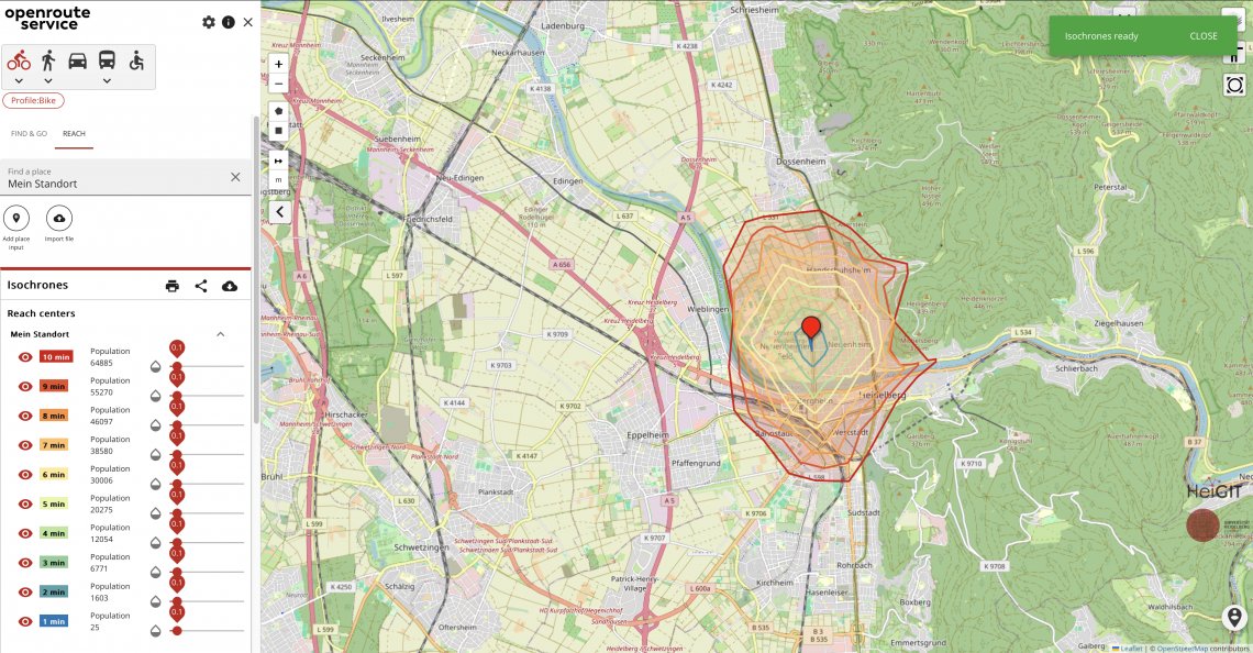
Region Sjælland siger max 20 km til vaccine fase 3 (den store gruppe) - kan ikke blive klog på om det er i fugleflugtslinje - eller 20 km via vejnettet de mener. På vejnettet kan du lave isokrone analyser på 20 km fra vaccinestedet via #openrouteservice


using @ors_news and @QGIS to plan a bike trip map data: © #OpenStreetMap contributors #openrouteservice


Using #Openrouteservice from the @UniHeidelberg was so easy, we are working on a plugin for @qgis ... stay tuned!


Med alt det fokus der er på cykling fra. off. side - så forstår jeg ikke at kommunerne ikke bruger fx isokrone analyser fra #openrouteservice - her 15 km el-cykel fra Herning centrum. Analyse kan HTML emb. samt download GeoJSON til viderebrug fx i QGIS. Data fra #openstreetmap


RT @pascal_n: #openrouteservice Website now supports GeoLocation-API of #FireFox 3.5
KomGIS+ integriert den Open Route Service geoobserver.de/2025/09/10/kom… #ORS #OpenRouteService #KomGIS #gistribe #gischat #fossgis #foss4g #OSGeo #spatial #geospatial #gis #geo #geoObserver pls RT

Er du holdkaptajn i "Vi cykler på arbejde" @cyklistforbund #vcta - så kan du vise resten af din org/firma disse fede isokrone analyser fra #openrouteservice - Case i billede - hvor langt kan man på elcykel komme fra Leo Pharma på hhv. 15, 30 og 45 min. Kilde #openstreetmap data


@MapSurferNET is alive again and accessible via the #openrouteservice API - @quaeldichde is one of our first happy users - have a look quaeldich.de/paesse/mont-ve… - and don't forget to sign up now at openrouteservice.org and request tiles for free.

KomGIS+ integriert den Open Route Service geoobserver.de/2025/09/10/kom… #ORS #OpenRouteService #KomGIS #gistribe #gischat #fossgis #foss4g #OSGeo #spatial #geospatial #gis #geo #geoObserver pls RT

🚀 Smart Njira just leveled up! 📍 Plan routes using place names or coordinates 🗺️ Download routes as GeoJSON for further analysis in GIS tools ⚙️ UTM/WGS84 switching, drawing tools, satellite view & more! …-f77m6skm5bmhgdulutvtrr.streamlit.app #GIS #Streamlit #OpenRouteService

This is our last post on X. Our account will go dormant tomorrow. We will keep posting about #openrouteservice, #OpenStreetMap ad other #geodata-related topics on our other social media channels:

#openrouteservice update! #ORS now has #export and #snap endpoints, changing the way users interact with and process routing data, making it easier to handle complex use cases or pre-process points for routing queries. More info: heigit.org/openrouteservi…

With #Streamlit, building apps is easy and fast. On Day 24 of #PythonDatavizChallenge, you will build a Geocoder app that can take an address and display it on the map using #OpenRouteService API. youtube.com/watch?v=hvQFK5…

youtube.com
YouTube
Building a Simple Geocoder App with Streamlit - Mapping and Data...

#30DayMapChallenge Day 4: 🏫Lessons in Traffic🏫 The map shows how rush hour travel times to Nairobi’s Central Business District (CBD) change during school term. 🗺️created with #openrouteservice & #UberMovement data for a study by @maze2punkt0 et al: tinyurl.com/lessons-in-tra…

#30DayMapChallenge Day 2: 🚗Urban Routing Networks🚗 Using #openrouteservice and #OSM data, @maze2punkt0 analyzed fastest vs shortest car routes in Birmingham & Copenhagen: 🔹Fewer, central roads dominate fastest routes. 🔹Shortest routes spread traffic across more streets.

🚨@ors_news: #openrouteservice update! #ORS now has #export and #snap endpoints, changing the way users interact with and process routing data, making it easier to handle complex use cases or pre-process points for routing queries. More info here: heigit.org/openrouteservi…

❗️Big News❗️ With the EU-Project "Gitterzellendatenbank", @BKG_Bund and partners have taken action to make #FreeOpenGeodata more accessible. Based on #OSM and #openrouteservice, the project offers information on the reachability of various facilites across Germany. ⬇️More Info

🎉 Exciting news! 🎉 Introducing openrouteservice version 8.0 - "Wilfried"! 🚀 Dedicated to Wilfried Juling for his invaluable contributions. Experience a wave of enhancements and fixes. Dive in now! heigit.org/introducing-op… #openrouteservice #Innovation #HeiGIT #routing

➡️ Das Heidelberg Institute for Geoinformation Technology #HeiGIT und das BKG kooperieren beim Thema #Routing. Auf Basis von #openrouteservice stellt das BKG dem Bund #RoutingPlus bereit. 🗣️ J. Psotta und F. Micklich berichten auf der @FOSSGIS_Konf. ⤵️ buff.ly/494BZOL

We then learn how to compute the distance between 2 cities - first using the #Python Standard library, then #GeoPy, and eventually learning about Web APIs and calculating real-world driving distance using the #OpenRouteService API. youtube.com/watch?v=kgY2np… (3/n)
Our projects: heigit.org/what-we-do/ Where else to find us: heigit.org/contact/ #OpenRouteService #ClimateAction #FreeOpenData #HumanitarianAid #Mapathon #MissingMaps #HEALproject #SketchMapTool #SmartMobility #GIScience
Pero que complemento lindo este de #OpenRouteService! Resuelve problemas de ruteo en segundos con datos de #OpenStreetMap.
🌍⚕️#HeiGIT member Julian Psotta participated in a panel discussion at the @ghsc_summit 2023. 🧭He presented our #openrouteservice tool, highlighting the importance of #open #free #geodata in the distribution of medical supplies. Follow @ors_news or the link below for more info!

#30DayMapChallenge Día 19: 5-minute map. Spend no more than 5 minutes to prepare this map "Caminata en intervalos de a 5 minutos desde el centro de la Ciudad" #OpenRouteService #OpenStreetMap #IDE #Pergamino

#30DayMapChallenge Día 7: Navigation, A map that helps you to navigate "De una punta a la otra en #Pergamino" #OpenRouteService es un servicio de ruteo basado en #OpenStreetMap, que puede ser consultado mediante su API.


No dobrze - rozmawiamy o samochodzie, dla uproszczenia 10 minut żeby S7 z Kielc nie jeździć. Mnichów Rudki (proj.) i Miąsowa (istniejąca) (dane #OpenRouteService)


#OpenRouteService und die NYTimes geoobserver.wordpress.com/2019/04/25/ope… #gis #geo #gistribe #spatial #geospatial #openstreetmap #geoobserver
Pero que complemento lindo este de #OpenRouteService! Resuelve problemas de ruteo en segundos con datos de #OpenStreetMap.
KomGIS+ integriert den Open Route Service geoobserver.de/2025/09/10/kom… #ORS #OpenRouteService #KomGIS #gistribe #gischat #fossgis #foss4g #OSGeo #spatial #geospatial #gis #geo #geoObserver pls RT
Isochrones map by time on cars between cities Lutsk an Rivne, Ukraine. on the left is Lutsk - Population: 217,103 on the right is Rivne city - Population: 247,356 #30DayMapChallenge Day 03: Polygons #qgis #openrouteservice
Viele Menschen in #Magdeburg fragen sich, wie sie heute ohne ÖPNV zum Fußball kommen. Wir haben mit #OpenRouteService die Reichweite für 10/20/30 min Radfahren zum Stadion berechnet (Isochronen). Es ist praktisch ganz Magdeburg erreichbar. Mit nem Pedelec gehts noch schneller. 😉
We then learn how to compute the distance between 2 cities - first using the #Python Standard library, then #GeoPy, and eventually learning about Web APIs and calculating real-world driving distance using the #OpenRouteService API. youtube.com/watch?v=kgY2np… (3/n)
Using #Openrouteservice from the @UniHeidelberg was so easy, we are working on a plugin for @qgis ... stay tuned!
Ud af 84 lande forskerne kommer fra er det især i forskning i Tyskland, UK og USA. Og især Heidelberg Uni, Tyskland (dem der står bag #openrouteservice , og mange andre værktøjer) - kommer ca. 184 videnskabelige papirer 2/3
Region Sjælland siger max 20 km til vaccine fase 3 (den store gruppe) - kan ikke blive klog på om det er i fugleflugtslinje - eller 20 km via vejnettet de mener. På vejnettet kan du lave isokrone analyser på 20 km fra vaccinestedet via #openrouteservice
using @ors_news and @QGIS to plan a bike trip map data: © #OpenStreetMap contributors #openrouteservice
#30DayMapChallenge Día 7: Navigation, A map that helps you to navigate "De una punta a la otra en #Pergamino" #OpenRouteService es un servicio de ruteo basado en #OpenStreetMap, que puede ser consultado mediante su API.

Impressionnant #OpenRouteService @ors_news : des outils de calculs d'itinéraires pour @qgis + 1 application web à l'IHM léchée + 5 différentes #APIs pour les développeurs. openrouteservice.org/services/ Pas de quoi rougir face aux "grands". #géocodage #isochrones #matriceOD #opensource


Med alt det fokus der er på cykling fra. off. side - så forstår jeg ikke at kommunerne ikke bruger fx isokrone analyser fra #openrouteservice - her 15 km el-cykel fra Herning centrum. Analyse kan HTML emb. samt download GeoJSON til viderebrug fx i QGIS. Data fra #openstreetmap
#30DayMapChallenge Día 19: 5-minute map. Spend no more than 5 minutes to prepare this map "Caminata en intervalos de a 5 minutos desde el centro de la Ciudad" #OpenRouteService #OpenStreetMap #IDE #Pergamino
#Openrouteservice introduces an updated wheelchair profile for Europe. Accessible routes that make sense - maps.openrouteservice.org

🚀 Smart Njira just leveled up! 📍 Plan routes using place names or coordinates 🗺️ Download routes as GeoJSON for further analysis in GIS tools ⚙️ UTM/WGS84 switching, drawing tools, satellite view & more! …-f77m6skm5bmhgdulutvtrr.streamlit.app #GIS #Streamlit #OpenRouteService
Something went wrong.
Something went wrong.
United States Trends
- 1. Good Wednesday 28.2K posts
- 2. Jameis 2,961 posts
- 3. #wednesdaymotivation 4,040 posts
- 4. Crypto ETFs 2,984 posts
- 5. #Wednesdayvibe 2,148 posts
- 6. #Talus_Labs N/A
- 7. Hump Day 12.8K posts
- 8. PancakeSwap BNB Chain 2,325 posts
- 9. ADOR 68.8K posts
- 10. #hazbinhotelseason2 45.7K posts
- 11. H-1B 51.5K posts
- 12. Happy Hump 8,157 posts
- 13. #WednesdayWisdom 23.1K posts
- 14. Northern Lights 54.8K posts
- 15. Jack Schlossberg 2,900 posts
- 16. Antarctica 9,487 posts
- 17. Justified 21.6K posts
- 18. Hanni 20.5K posts
- 19. STEM 16.4K posts
- 20. Neil Young 1,842 posts