#rasterfunctions 검색 결과

Here I apply #RasterFunctions to generalize and homogenize similar color areas in order to sample them later with the eyedropper tool. For this I split the RGB bands, perform resample and neighbor statistics, then composite back again. #cARTography #MakingMapsPretty #ArcGISPro
Different generalizations for different zoom levels combined with scale-dependent visibility to produce a multi-scale, multi-directional shaded relief, about to be published as a tile layer for an online map. #NasaDem processed with #RasterFunctions in #ArcGISPro. #cARTography
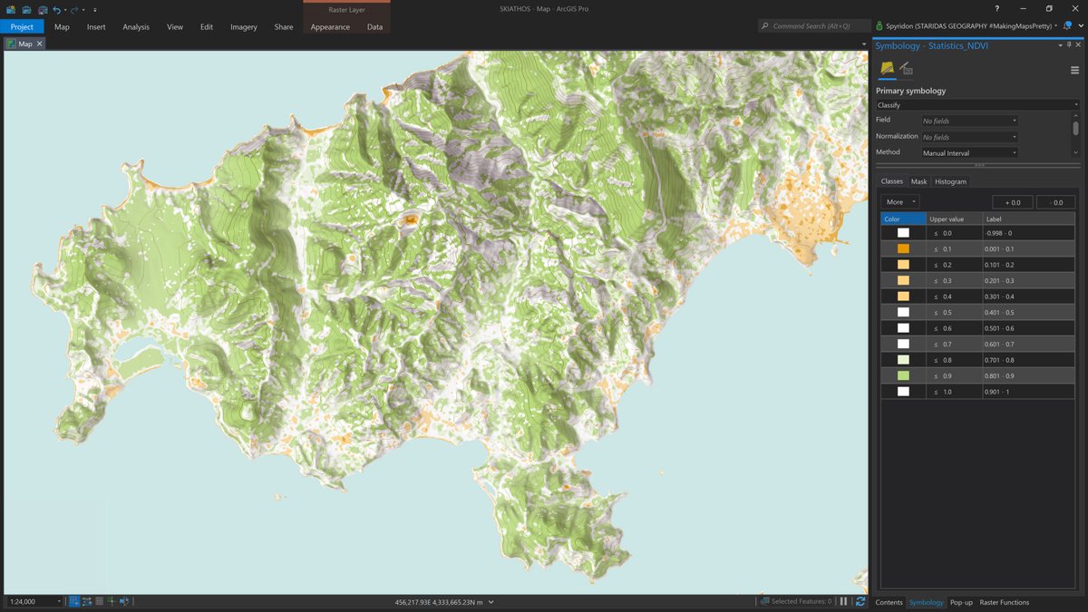
Land cover from #Sentinel2 with #RasterFunctions in #ArcGISPro completes the topo basemap. #cARTography #MakingMapsPretty
I wrote a blog post on how to extract the lovely colors of an old map with #RasterFunctions and the eyedropper tool in #ArcGISPro here staridasgeography.gr/lovely-colors-… #cARTography #MakingMapsPretty @ArcGISPro
staridasgeography.gr
Lovely Colors from an Old Map in ArcGIS Pro
Sampling colors with the eyedropper tool from an old map, generalized with Raster functions in ArcGIS Pro, then saving them in a custom Style.

another free and useful learning resource: analyzing declining malaria rates in Africa. esri.com/arcgis-blog/pr… #rasterfunctions

#EsriUC 5 R&D focuses lately re: #remotesensing 1.bring in any dataset 2. Better image mgmt including indexed spatiotemporal cubes 3. Better map production with imagery 4. Better analysis capabilities (learn about #rasterfunctions if you havent) 5. Better search, discovery, & viz
I wrote a blog post on how to extract the lovely colors of an old map with #RasterFunctions and the eyedropper tool in #ArcGISPro here staridasgeography.gr/lovely-colors-… #cARTography #MakingMapsPretty @ArcGISPro
staridasgeography.gr
Lovely Colors from an Old Map in ArcGIS Pro
Sampling colors with the eyedropper tool from an old map, generalized with Raster functions in ArcGIS Pro, then saving them in a custom Style.
Here I apply #RasterFunctions to generalize and homogenize similar color areas in order to sample them later with the eyedropper tool. For this I split the RGB bands, perform resample and neighbor statistics, then composite back again. #cARTography #MakingMapsPretty #ArcGISPro
Different generalizations for different zoom levels combined with scale-dependent visibility to produce a multi-scale, multi-directional shaded relief, about to be published as a tile layer for an online map. #NasaDem processed with #RasterFunctions in #ArcGISPro. #cARTography
Land cover from #Sentinel2 with #RasterFunctions in #ArcGISPro completes the topo basemap. #cARTography #MakingMapsPretty
#EsriUC 5 R&D focuses lately re: #remotesensing 1.bring in any dataset 2. Better image mgmt including indexed spatiotemporal cubes 3. Better map production with imagery 4. Better analysis capabilities (learn about #rasterfunctions if you havent) 5. Better search, discovery, & viz
another free and useful learning resource: analyzing declining malaria rates in Africa. esri.com/arcgis-blog/pr… #rasterfunctions
Land cover from #Sentinel2 with #RasterFunctions in #ArcGISPro completes the topo basemap. #cARTography #MakingMapsPretty
Something went wrong.
Something went wrong.
United States Trends
- 1. #WorldSeries 145K posts
- 2. Dodgers 215K posts
- 3. Rojas 41.6K posts
- 4. Blue Jays 84.8K posts
- 5. Yamamoto 37.3K posts
- 6. Ohtani 63.6K posts
- 7. Toronto 58.7K posts
- 8. Ernie Clement 10.5K posts
- 9. Auburn 12.1K posts
- 10. Hoffman 9,627 posts
- 11. Hugh Freeze 4,274 posts
- 12. Andy Pages 2,506 posts
- 13. Vlad 10.4K posts
- 14. #SNME 79.4K posts
- 15. Heupel 2,150 posts
- 16. Snell 6,744 posts
- 17. Dominguez 3,561 posts
- 18. Mateer 3,334 posts
- 19. Dave Roberts 6,154 posts
- 20. #Worlds2025 26.3K posts