#sspwindex 搜尋結果
See 9/17 reply to Jim Cantore. Or other #SSPWINdex posts, 2 years+. #HurricaneJohn, EPAC, is way stronger than forecast yesterday. IMO, sign of a strong SSPW Long wave. Geomagnetic storm now. Respect odd #Helene intensity possibilities. #natgas #hurricane #spaceweather

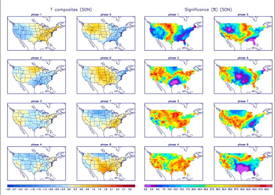
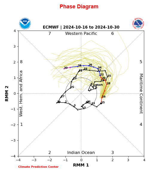
See 9/18 temperature forecast post for late October. My MJO reasoning - thoughts (#SSPWIndex forced), looks to be in line if the ECMWF forecast is correct. Although maybe slower. SON composite supports warmth as well. Wait and see game now. #Natgas #solarcycle25 #spaceweather
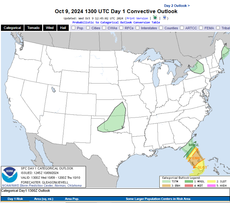
In reference to my 9/18 #tornado uptick post, for 10/7-9, based upon the #SSPWIndex waves, and my own research into this relationship. I have already seen a couple of tornado videos coming out of Florida. Here is the latest CPC forecast. #Milton
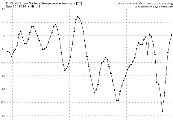
See 9/11 forecast post #SSPWIndex based. Westerlies ahead 160E-160W. Even my 9/19 update showed the models were too weak. Westerlies showed up. Recent SST #LaNina temps are gone. 9/25, Region 3.4 at -.282, R3.0 huge warming +.006, R4.0 +.268 #natgas #solarcycle25 #spaceweather

Do not take out of context. Many variables, #SSPWIndex combination wise, are important. But some scenarios can be better in a subpar developmental season. I posted two days ago about the garbage solar wind. See prior posts about the #DSTIndex. 😂 #99L #Francine #tropics #SC25

In regard to 8/20 post, tropical uptick forecast, 9/4-6. And 8/30 post, warmer pattern ahead 9/12-14. Cold can = light switch with tropics. Cold did come 9/4, but 9/8 cold stronger. Tropical uptick followed. Warming wave is obvious. #SSPWIndex is useless? OK #natgas #SC25
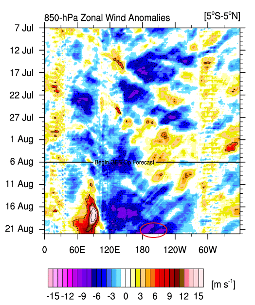
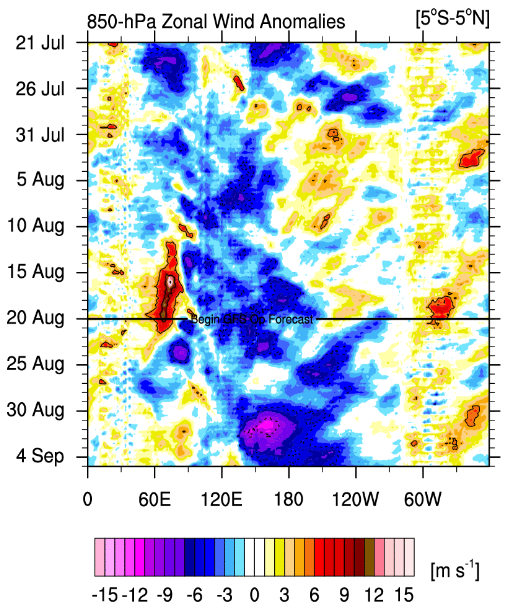
Per my repost yesterday morning in regard to August 7th forecast post. You can see that the extreme easterlies, -9 or so, 180-140W, 20th-22nd, is not happening. You even had neutral-weak westerlies on the outskirts. Models favor #LaNina atmosphere. IDK why. #Natgas #SSPWIndex
The dam is weakening and ready to breach in regard to the solar & space weather relationship to our weather & climate. The powers that be will not be able to hold it back anymore. Game, set, match for the #SSPWIndex
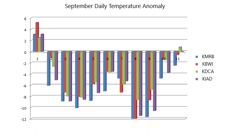
Anyone living around the Balt-Wash region knows that we woke up to a different air mass this morning. IDC about some positive anomalies still being around. The #SSPWIndex worked pretty damn well for the region from 43 days out. More updates on Monday with some actual hard data.
I have made several extended activity forecasts for #severeweather- #tornado, based upon the #SSPWIndex over the last couple of years. The windows have been active. The Oct 7th-9th window looks good, % 👇. #natgas #SolarCycle25 #spaceweather x.com/JimWindweather…
I have shown how the #SSPWIndex can forecast certain patterns. Which implies changing air mass flows. Research data shows variable dominance, and threshold crossings, are important. #Tornado outbreaks tend to happen during extreme percentage swings #Natgas #Climatechange #weather

The 5/10-11 severe geomagnetic storm also implied solar cycle changes ahead. Which than equals long range busts. #LaNina, #tropics, etc. You got lucky with your summer temperature pattern calls. Our region's extreme temp waves line up with the #SSPWIndex. #natgas #SC25
When long range weather forecasters finally figure out what rapid solar-space weather changes can do to some of their long-range forecasts. #SolarCycle25 #GWO #MJO #Climatechange #LaNina #ElNino #Natgas #Tropics #PDO
The #SSPWIndex has no value? Last week's forecast, 8/22, had me at 87-88 for a high yesterday. We hit 94. The Balt-Wash area was hotter. The high temps for DCA, BWI, and Dulles, were 101, 97, and 99 respectively. All monthly highs. Cool air coming #Natgas #SolarCycle25 #Heat
Heat thoughts for #Natgas crowd. Warmer forecast ahead, starting Sunday, looks legit For WV - Balt-Wash area. Warmest anomaly should be centered around 8/28. Active tropics, 9/4-6, usually preceded by cooler pattern. Do not extend warm temps to long #SolarCycle25 #SSPWIndex
10/23 reply to @ReedTimmer after he showed a model run. My comments were based upon some of the #SSPWIndex variables and what they can point toward. But I also consider checks and balances with their wave pattern differences. Will post something soon. x.com/JimWindweather…
There is a cold look around this time frame, SSPW wise. This can usually imply an active tropics, and severe weather. Not sold with the latter though, tornado wise. Prefer much later time frame for that possibility. But I'd respect the possibility if it keeps showing up.
It stands for Solar Space weather. I added the P to keep it being confused with the SSW term. Which is used to describe a condition /event in the polar stratosphere. Search #SSPWIndex for previous weather & climate discussions for different things. Besides the tropics
The #SSPWIndex relationship is not just for the tropics. It affects many of the North American patterns. My research has mainly dealt with the east because I live here. But have shown some relationships with the EPO & PNA phases in the past. Research wise. x.com/JimWindweather…
Heat thoughts for #Natgas crowd. Warmer forecast ahead, starting Sunday, looks legit For WV - Balt-Wash area. Warmest anomaly should be centered around 8/28. Active tropics, 9/4-6, usually preceded by cooler pattern. Do not extend warm temps to long #SolarCycle25 #SSPWIndex
10/23 reply to @ReedTimmer after he showed a model run. My comments were based upon some of the #SSPWIndex variables and what they can point toward. But I also consider checks and balances with their wave pattern differences. Will post something soon. x.com/JimWindweather…
There is a cold look around this time frame, SSPW wise. This can usually imply an active tropics, and severe weather. Not sold with the latter though, tornado wise. Prefer much later time frame for that possibility. But I'd respect the possibility if it keeps showing up.
Anyone living around the Balt-Wash region knows that we woke up to a different air mass this morning. IDC about some positive anomalies still being around. The #SSPWIndex worked pretty damn well for the region from 43 days out. More updates on Monday with some actual hard data.
See 9/18 temperature forecast post for late October. My MJO reasoning - thoughts (#SSPWIndex forced), looks to be in line if the ECMWF forecast is correct. Although maybe slower. SON composite supports warmth as well. Wait and see game now. #Natgas #solarcycle25 #spaceweather


In reference to my 9/18 #tornado uptick post, for 10/7-9, based upon the #SSPWIndex waves, and my own research into this relationship. I have already seen a couple of tornado videos coming out of Florida. Here is the latest CPC forecast. #Milton

See 9/11 forecast post #SSPWIndex based. Westerlies ahead 160E-160W. Even my 9/19 update showed the models were too weak. Westerlies showed up. Recent SST #LaNina temps are gone. 9/25, Region 3.4 at -.282, R3.0 huge warming +.006, R4.0 +.268 #natgas #solarcycle25 #spaceweather


See 9/17 reply to Jim Cantore. Or other #SSPWINdex posts, 2 years+. #HurricaneJohn, EPAC, is way stronger than forecast yesterday. IMO, sign of a strong SSPW Long wave. Geomagnetic storm now. Respect odd #Helene intensity possibilities. #natgas #hurricane #spaceweather

I have made several extended activity forecasts for #severeweather- #tornado, based upon the #SSPWIndex over the last couple of years. The windows have been active. The Oct 7th-9th window looks good, % 👇. #natgas #SolarCycle25 #spaceweather x.com/JimWindweather…
I have shown how the #SSPWIndex can forecast certain patterns. Which implies changing air mass flows. Research data shows variable dominance, and threshold crossings, are important. #Tornado outbreaks tend to happen during extreme percentage swings #Natgas #Climatechange #weather

In regard to 8/20 post, tropical uptick forecast, 9/4-6. And 8/30 post, warmer pattern ahead 9/12-14. Cold can = light switch with tropics. Cold did come 9/4, but 9/8 cold stronger. Tropical uptick followed. Warming wave is obvious. #SSPWIndex is useless? OK #natgas #SC25

Do not take out of context. Many variables, #SSPWIndex combination wise, are important. But some scenarios can be better in a subpar developmental season. I posted two days ago about the garbage solar wind. See prior posts about the #DSTIndex. 😂 #99L #Francine #tropics #SC25

The 5/10-11 severe geomagnetic storm also implied solar cycle changes ahead. Which than equals long range busts. #LaNina, #tropics, etc. You got lucky with your summer temperature pattern calls. Our region's extreme temp waves line up with the #SSPWIndex. #natgas #SC25
When long range weather forecasters finally figure out what rapid solar-space weather changes can do to some of their long-range forecasts. #SolarCycle25 #GWO #MJO #Climatechange #LaNina #ElNino #Natgas #Tropics #PDO
The dam is weakening and ready to breach in regard to the solar & space weather relationship to our weather & climate. The powers that be will not be able to hold it back anymore. Game, set, match for the #SSPWIndex
The #SSPWIndex has no value? Last week's forecast, 8/22, had me at 87-88 for a high yesterday. We hit 94. The Balt-Wash area was hotter. The high temps for DCA, BWI, and Dulles, were 101, 97, and 99 respectively. All monthly highs. Cool air coming #Natgas #SolarCycle25 #Heat
Heat thoughts for #Natgas crowd. Warmer forecast ahead, starting Sunday, looks legit For WV - Balt-Wash area. Warmest anomaly should be centered around 8/28. Active tropics, 9/4-6, usually preceded by cooler pattern. Do not extend warm temps to long #SolarCycle25 #SSPWIndex
The #SSPWIndex relationship is not just for the tropics. It affects many of the North American patterns. My research has mainly dealt with the east because I live here. But have shown some relationships with the EPO & PNA phases in the past. Research wise. x.com/JimWindweather…
Heat thoughts for #Natgas crowd. Warmer forecast ahead, starting Sunday, looks legit For WV - Balt-Wash area. Warmest anomaly should be centered around 8/28. Active tropics, 9/4-6, usually preceded by cooler pattern. Do not extend warm temps to long #SolarCycle25 #SSPWIndex
Per my repost yesterday morning in regard to August 7th forecast post. You can see that the extreme easterlies, -9 or so, 180-140W, 20th-22nd, is not happening. You even had neutral-weak westerlies on the outskirts. Models favor #LaNina atmosphere. IDK why. #Natgas #SSPWIndex

It stands for Solar Space weather. I added the P to keep it being confused with the SSW term. Which is used to describe a condition /event in the polar stratosphere. Search #SSPWIndex for previous weather & climate discussions for different things. Besides the tropics
Heat thoughts for #Natgas crowd. Warmer forecast ahead, starting Sunday, looks legit For WV - Balt-Wash area. Warmest anomaly should be centered around 8/28. Active tropics, 9/4-6, usually preceded by cooler pattern. Do not extend warm temps to long #SolarCycle25 #SSPWIndex
The #SSPWIndex pulled a model coup in regard to what I circled twelve days ago. I thought the overall aggressiveness was too strong. The #LaNina, Atlantic basin activity, EPAC #tropics, all were long range miscues to this point. SSPW waves do matter. #natgas #SolarCycle25
From 7/15 initially. The response is happening again in tandem with the #SSPWIndex variables. Anyone who thinks this is a closed system response, as in earth's climate environment alone, is kidding themselves and the public in general. x.com/JimWindweather…
I told Danny back in a July 15th reply that this time period had legs based on the #SSPW long wave. Window should open around August 10th. The following 7-10 days look the best for development & enhancement. I like 8/15-17. #tropics #natgas #SolarCycle25 #spaceweather
It's a compliment when individuals, and long-range outfits start talking about things after you bring attention to it. But beware of analog usage. You're throwing darts blindfolded. You need a #SSPWIndex repeat. #Natgas #AAO #SolarCycle25 #spaceweather x.com/JimWindweather…
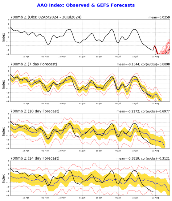
SH bubble continues. I know many people would love to see this happen with the AO this upcoming winter. It will be interesting to see what level the -AAO reaches in the next week. This winter will be both tough and fun to forecast. #Natgas #SolarCycle25 #Spaceweather #AAO
See 9/17 reply to Jim Cantore. Or other #SSPWINdex posts, 2 years+. #HurricaneJohn, EPAC, is way stronger than forecast yesterday. IMO, sign of a strong SSPW Long wave. Geomagnetic storm now. Respect odd #Helene intensity possibilities. #natgas #hurricane #spaceweather

See 9/18 temperature forecast post for late October. My MJO reasoning - thoughts (#SSPWIndex forced), looks to be in line if the ECMWF forecast is correct. Although maybe slower. SON composite supports warmth as well. Wait and see game now. #Natgas #solarcycle25 #spaceweather


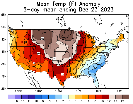
See 11/2 forecasts (3) post. A two- day shift from a 45 day out forecast.👇The 19th-23rd is the ONLY 5-day period in Dec that had below avg temps along the east coast (But not very cold). I said 17th-21st. 12/19 shown below also #Natgas #SSPWIndex #SolarCycle25 #Cold #ElNino

See 9/11 forecast post #SSPWIndex based. Westerlies ahead 160E-160W. Even my 9/19 update showed the models were too weak. Westerlies showed up. Recent SST #LaNina temps are gone. 9/25, Region 3.4 at -.282, R3.0 huge warming +.006, R4.0 +.268 #natgas #solarcycle25 #spaceweather


In reference to my 9/18 #tornado uptick post, for 10/7-9, based upon the #SSPWIndex waves, and my own research into this relationship. I have already seen a couple of tornado videos coming out of Florida. Here is the latest CPC forecast. #Milton

Do not take out of context. Many variables, #SSPWIndex combination wise, are important. But some scenarios can be better in a subpar developmental season. I posted two days ago about the garbage solar wind. See prior posts about the #DSTIndex. 😂 #99L #Francine #tropics #SC25

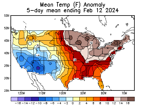
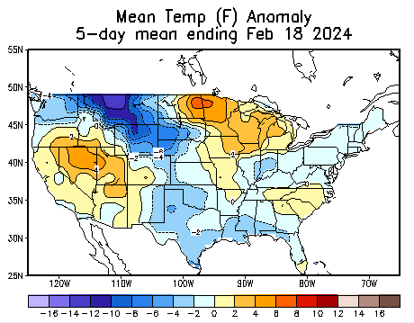
The 1st 12 Feb days at KMRB had 7 > 50 degrees. Two 66 days. +8.0 avg. Last six? One 50 day because of fluke evening wind change. Compresses down the mountain. KIAD (Dulles) shows this also. Last 6-day avg? -.8. Snowed 13th and 17th (Coldest Feb day) #Natgas #SSPWIndex #waves
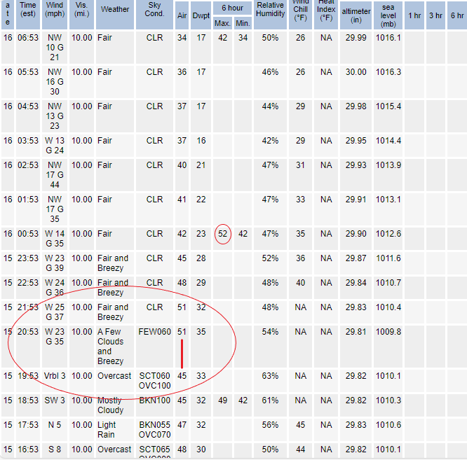
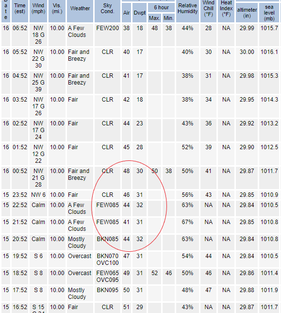
See 1/26 post. Some care about forecasts & $$. Thats fine. I only care about researching wave patterns forced by #SSPWIndex. Pattern changed on 13th. Real cold? No. But avg Temps dropped & snow (2). Before & after.👇 Said #Warmth was ahead. #natgas #SolarCycle25 #ELNino #LaNina
In regard to 8/20 post, tropical uptick forecast, 9/4-6. And 8/30 post, warmer pattern ahead 9/12-14. Cold can = light switch with tropics. Cold did come 9/4, but 9/8 cold stronger. Tropical uptick followed. Warming wave is obvious. #SSPWIndex is useless? OK #natgas #SC25

Per my repost yesterday morning in regard to August 7th forecast post. You can see that the extreme easterlies, -9 or so, 180-140W, 20th-22nd, is not happening. You even had neutral-weak westerlies on the outskirts. Models favor #LaNina atmosphere. IDK why. #Natgas #SSPWIndex

Something went wrong.
Something went wrong.
United States Trends
- 1. Michigan 105K posts
- 2. Ryan Day 4,175 posts
- 3. Bo Jackson 1,022 posts
- 4. Buckeyes 7,256 posts
- 5. #GoBlue 7,122 posts
- 6. #TheGame 3,099 posts
- 7. Barham 1,215 posts
- 8. Florida 105K posts
- 9. Texas 186K posts
- 10. Donaldson 1,325 posts
- 11. #SmallBusinessSaturday 2,862 posts
- 12. Julian Sayin 1,289 posts
- 13. Kentucky 17.3K posts
- 14. Gus Johnson N/A
- 15. #GoBucks 4,705 posts
- 16. Ann Arbor 3,389 posts
- 17. Leeds 32.9K posts
- 18. Stoops 1,055 posts
- 19. Grade 3 3,236 posts
- 20. Foden 21.1K posts


