#spatialdata 검색 결과

Every ecosystem has data. But only @integra_layer gives it a heartbeat. When movement becomes memory, and land becomes language, cities stop being structures they become stories. And suddenly, the world isn’t just mapped… it’s understood. #Integra #SpatialData #IRL


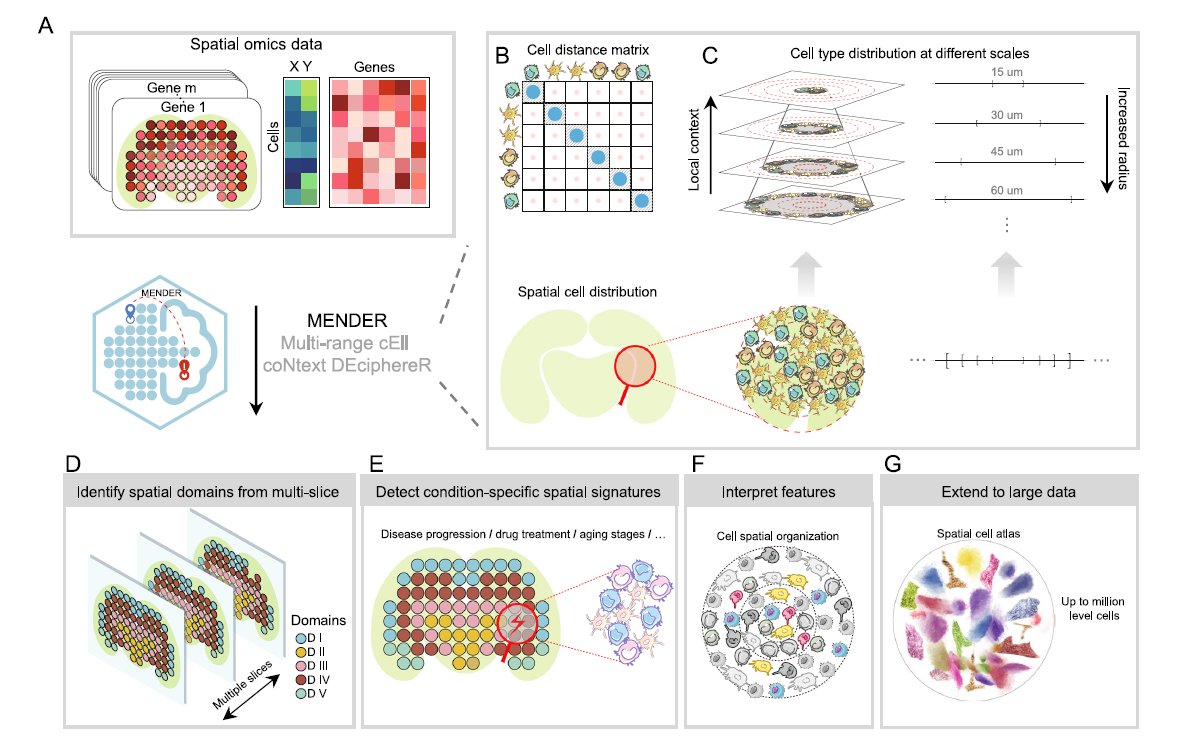
We love learning about new #ComputationalTools for analyzing #SpatialData! MENDER is a novel tissue structure identification tool utilizing cellular neighborhood structures observed across spatial technologies now published in @NatureComms. Learn more: hubs.ly/Q02fCYP20
Context. Clarity. A living map that understands itself. That’s when decisions become smarter, ecosystems grow faster, and onchain truly meets the real world. @integra_layer #Integra #IRL #SpatialData

This is how real estate evolves: not with buzzwords, but with a chain that can actually understand the world it’s securing. #Integra #IRL #SpatialData


Awesome week last week representing both @napari_imaging and #SpatialData @scverse at @EuroSciPy2024. It was great to meet maintainers and contributors to the libraries we use. Also grateful for the opportunity to have a flashlight talk on #numpydantic and a little bit on #LinkML


🌐 Introducing PA statistical methods: Geographic Information Systems (GIS). This integrates spatial data, ideal for exploring environmental influences on physical activity. GIS requires extensive data handling skills. #SpatialData #PhysicalActivityResearch


2 WEEKS AWAY! 🥳 Prevent yourself from future FOMO & sign up for Esri's popular course today: esri.social/xJq350SWk38 #SpatialDataScience #ArcGIS #SpatialData

Happy to share earlier this month, Avipsa Roy, Asst Prof in Urban Planning & Public Policy was invited as a guest lecturer to discuss Spatial Data Science's influence on policy making at IIT Kharagpur, Visva Bharati University, ISI Kolkata, and IISc Bengaluru. #spatialdata #up3


URHIAsti on stage today 11.00 🇪🇪@utuscience @UniTurku #spatialdata #foss4ge @foss4ge @HuDi_Project @BEDLAN_Uralic


Today presenting current status at the #foss4ge2024 Tartu “URHIA's Open Data Journey in Spatial Exploration” 📅Fri, 5.7.2024 at 11.00 📍Omicum building Live stream link available foss4ge.television.ee

📍 Looking to expand your business to new locations, but worried about the impact on existing sales? You need Cannibalization Analysis! Maximize profits and safeguard existing revenue with this step-by-step tutorial 👉 hubs.ly/Q02wMFYv0 #analytics #spatialdata

Big up to Wajumbe👏🥳 for aiding mappers on the ground with their invaluable local knowledge & resident trust. They play a crucial role in gathering accurate #spatialdata for the baseline survey & pinpointing initial information, i.e., WCP's locations, dumping sites & waste piles
📍 Looking to expand your business to new locations, but worried about the impact on existing sites? You need Cannibalization Analysis! Maximize profits and safeguard existing revenue with this step-by-step tutorial 👉 hubs.ly/Q02DqVqK0 #analytics #spatialdata

Applied #SpatialData! #BigData #Analytics #DataScience #AI #MachineLearning #IoT #IIoT #GeoSpatial #Python #RStats #TensorFlow #Java #JavaScript #ReactJS #GoLang #CloudComputing #Serverless #DataScientist #Linux #Programming #Coding #100DaysofCode geni.us/Applied-Spatia…


And they're not keeping it to themselves. This same spatial dataset is now being used by leading AI companies to build the next generation of intelligent machines. The future of AI isn't just virtual. It's spatial. #VisionAI #Robotics #SpatialData #AI

making spatial data easy for pros and non-gis users, catch the full video exclusively on collide.io #gis #spatialdata #dataplatform


Ready to tackle climate risk? 🌍 See how CARTO helps insurers analyze threats like hurricanes & fires with seamless spatial insights. 📩 Request your demo now: hubs.ly/Q02_3zlc0 #ClimateRisk #SpatialData #CARTO #DataAnalytics

What is @ApacheSedona and what are its common use cases? Discover how this clustering computing system, designed for processing large-scale spatial data, treats spatial data as a first-class citizen. bit.ly/3ZRL24U #ApacheSeonda #SpatialData

We love learning about new #ComputationalTools for analyzing #SpatialData! MENDER is a novel tissue structure identification tool utilizing cellular neighborhood structures observed across spatial technologies now published in @NatureComms. Learn more: hubs.ly/Q02fCYP20
Every ecosystem has data. But only @integra_layer gives it a heartbeat. When movement becomes memory, and land becomes language, cities stop being structures they become stories. And suddenly, the world isn’t just mapped… it’s understood. #Integra #SpatialData #IRL
Context. Clarity. A living map that understands itself. That’s when decisions become smarter, ecosystems grow faster, and onchain truly meets the real world. @integra_layer #Integra #IRL #SpatialData

More oblique views. Now I'll have to find out how to bring point data to Blender so I can overlay precise locations. I've managed to bring in shapefile but haven't been able to convert that into object. #gis #blender #spatialdata


My latest article, 𝐄𝐱𝐩𝐥𝐨𝐫𝐢𝐧𝐠 𝐋𝐚𝐫𝐠𝐞-𝐬𝐜𝐚𝐥𝐞 𝐑𝐚𝐬𝐭𝐞𝐫 𝐏𝐨𝐩𝐮𝐥𝐚𝐭𝐢𝐨𝐧 𝐃𝐚𝐭𝐚, is out on @TDataScience: towardsdatascience.com/exploring-larg… #geosptaialdata #geodata #spatialdata #datavisualization #datascience #data #datafam #visualization #gis #geography


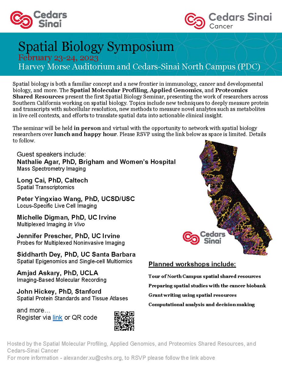
#CedarsSinaiCancer's first #SpatialBiology Symposium is taking place covering topics like new techniques to measure proteins, methods to measure novel analytes, and efforts to translate #spatialdata into clinical insights. Virtual attendees are welcome!
URHIAsti on stage today 11.00 🇪🇪@utuscience @UniTurku #spatialdata #foss4ge @foss4ge @HuDi_Project @BEDLAN_Uralic
Today presenting current status at the #foss4ge2024 Tartu “URHIA's Open Data Journey in Spatial Exploration” 📅Fri, 5.7.2024 at 11.00 📍Omicum building Live stream link available foss4ge.television.ee

#showcasing #students Jevaughn #spatialdata #analyst #Jamaica jevaughnhenry.wixsite.com/my-site/projec… #ePortfolio #PLUS #creative #drone #projects #Check his #CV & impressive #skills list 😎 #data #visualisation #UAV #Copernicus #DigitalEarth #EO #GI #Geocommunication #UPOL #Geospatial #MSc
This is how real estate evolves: not with buzzwords, but with a chain that can actually understand the world it’s securing. #Integra #IRL #SpatialData

Welcome to the 6th day of 12 Days of NanoString! Interested in leaping to single-cell spatial in these applications? nanostring.com/events/spatial… #SpatialData #CellSegmentation #SpatialTranscriptomics #SingleCellImaging

Applied #SpatialData! #BigData #Analytics #DataScience #AI #MachineLearning #IoT #IIoT #GeoSpatial #Python #RStats #TensorFlow #Java #JavaScript #ReactJS #GoLang #CloudComputing #Serverless #DataScientist #Linux #Programming #Coding #100DaysofCode geni.us/Applied-Spatia…
🌐 Introducing PA statistical methods: Geographic Information Systems (GIS). This integrates spatial data, ideal for exploring environmental influences on physical activity. GIS requires extensive data handling skills. #SpatialData #PhysicalActivityResearch

Dr. Urooj Saeed Senior Specialist GIS, presented GIS data sets, layers and analysis. The interactive session with CERP team included discussion on GIS & RS data, attributed data, spatial patterns & spatial data repository and big data repository. #DataAnalytics #spatialdata

My recent article, 𝐄𝐱𝐩𝐥𝐨𝐫𝐢𝐧𝐠 𝐋𝐚𝐫𝐠𝐞-𝐬𝐜𝐚𝐥𝐞 𝐑𝐚𝐬𝐭𝐞𝐫 𝐏𝐨𝐩𝐮𝐥𝐚𝐭𝐢𝐨𝐧 𝐃𝐚𝐭𝐚, published on @TDataScience: towardsdatascience.com/exploring-larg… @WorldPopProject #geosptaialdata #geodata #spatialdata #gis #geography #datascience #datavisualizatiom #ai


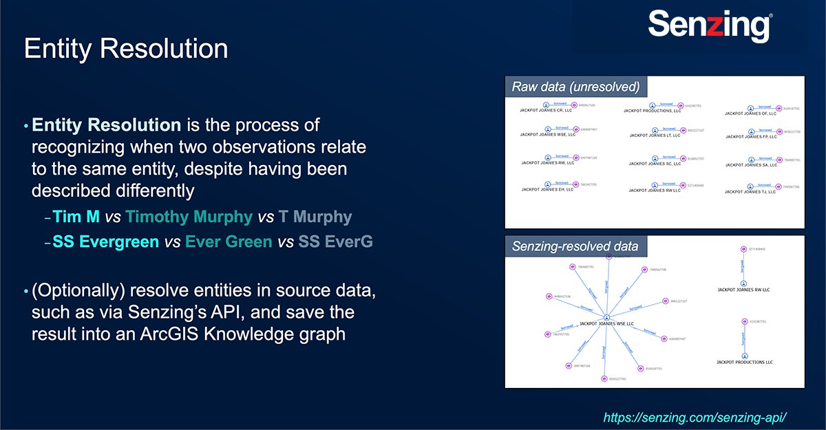
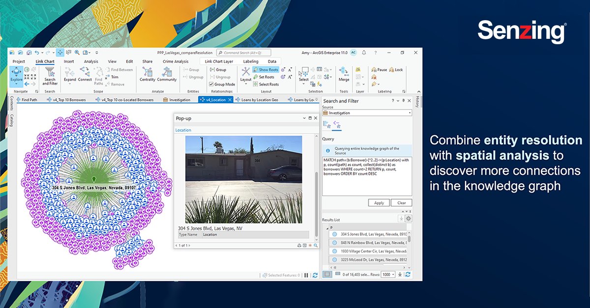
Last week my team and I attended #EsriFedGIS2023. @Senzing and @Esri have partnered to merge #NonSpatial third-party data together with #SpatialData using #ArcGIS Knowledge and perform link analysis using #ArcGISpro. #ArcGISKnowledge #SenzingPartner #ESRIPartner

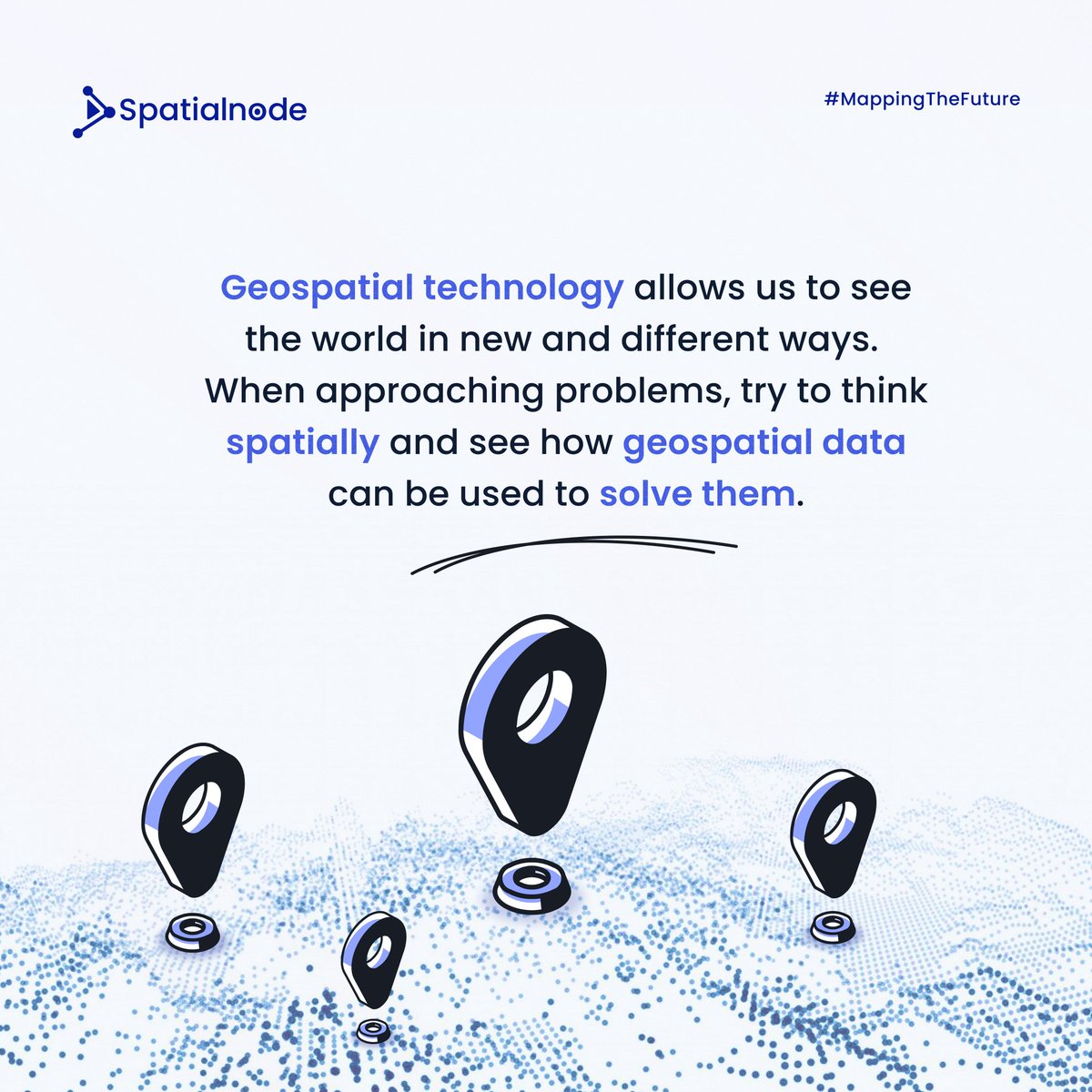
Spatialnode Monday Tips It's a new week! Let's think spatially this week! #geospatial #mondaymotivation #spatialdata
Awesome week last week representing both @napari_imaging and #SpatialData @scverse at @EuroSciPy2024. It was great to meet maintainers and contributors to the libraries we use. Also grateful for the opportunity to have a flashlight talk on #numpydantic and a little bit on #LinkML

An experienced data analyst provides tips and best practices for managing GIS workflows. esri.social/EK0y50R80N6 @URISA #DataAnalysis #GISWorkflow #SpatialData #DataManagement

Something went wrong.
Something went wrong.
United States Trends
- 1. Good Sunday 56.3K posts
- 2. SB19 ACONic PERFORMANCE 166K posts
- 3. Pearl Harbor 7,501 posts
- 4. Muhammad Qasim 4,936 posts
- 5. Indiana 108K posts
- 6. #sundayvibes 3,866 posts
- 7. Benin 48.1K posts
- 8. #UFC323 130K posts
- 9. Merab 48.6K posts
- 10. Walt 8,784 posts
- 11. Ohio State 65.5K posts
- 12. Duke 61.9K posts
- 13. Vtuber 88.4K posts
- 14. Mendoza 43.5K posts
- 15. Petr Yan 29.5K posts
- 16. Roach 29.4K posts
- 17. TOP CALL 8,877 posts
- 18. Pantoja 36.2K posts
- 19. Joshua Van 11.8K posts
- 20. Pitbull 18.9K posts