#surfacereflectance search results

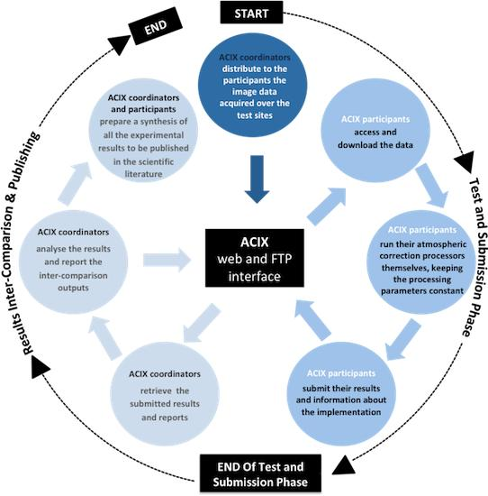
Atmospheric Correction Inter-Comparison Exercise by Georgia Doxani, Eric Vermote, et al. 2018 👉mdpi.com/2072-4292/10/2… #remotesensing #atmosphericcorrection #surfacereflectance #aerosolopticalthickness #watervapour #Sentinel2 #Landsat8

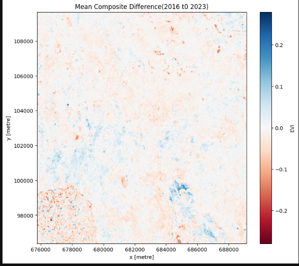
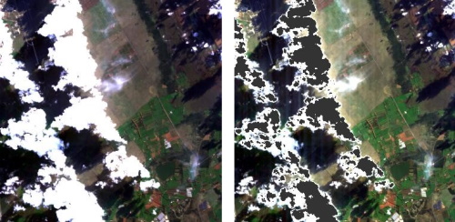
A simple Vegetation change detection of an area around Mt. Elgon, using @DEarthAfrica #DEAfricaSandbox #Landsat8 #surfacereflectance product, comparing two different times. Red areas show a negative change while blue ones a positive change. @kenmubea @ZvikoDM @JosephTUYISHIMI

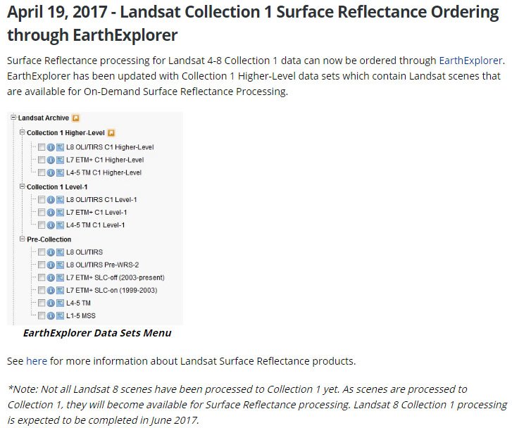
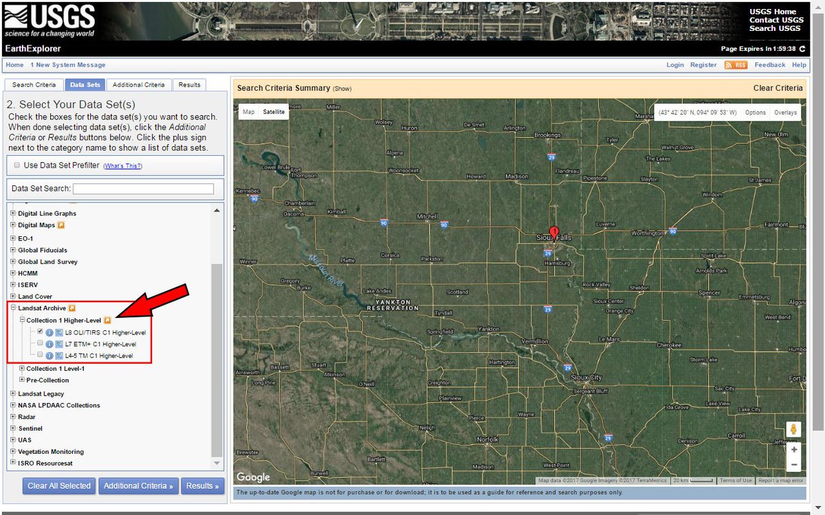
#LandsatHeadline: #LandsatCollection1 #surfacereflectance ordering through #EarthExplorer is now available. on.doi.gov/2oMU6pN
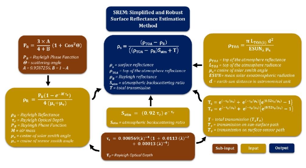
#RSHighlyCitedPaper A Simplified and Robust #SurfaceReflectance Estimation Method (#SREM) for Use over Diverse #LandSurfaces Using #MultiSensor Data By Muhammad Bilal, Majid Nazeer, et al. 👉mdpi.com/2072-4292/11/1… #remotesensing #Landsat #satellite #LEDAPS #LaSRC #SREM #NDVI
You can now order #Landsat #surfacereflectance from #EarthExplorer. earthexplorer.usgs.gov For more information see on.doi.gov/2oHdi8u
Did you know that the USGS provides research-quality, applications-ready #Landsat science products? Level-2 scene-based science products include #SurfaceReflectance, #SurfaceTemperature, #SpectralIndices, and Provisional #AquaticReflectance. More here: ow.ly/TQo450UOPIg

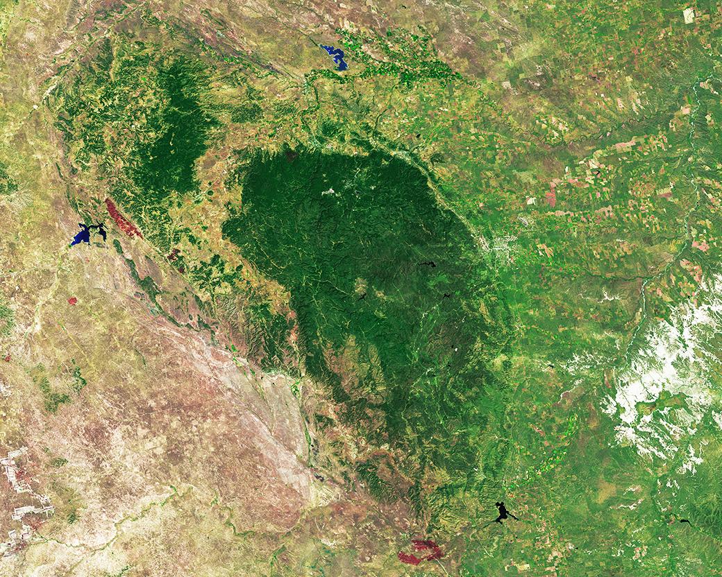
#OTD in 1987 @BlackHillsNF was established. The forest is surrounded by grasslands and agriculture as seen in this #Landsat8 #SurfaceReflectance image mosaic.
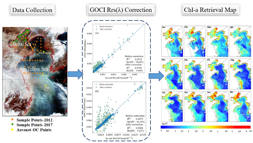
🌊🛰️👉 Quantitative Retrieval of #Chlorophyll-a Concentrations in the Bohai–Yellow Sea Using #GOCI #SurfaceReflectance Products ✍️ Jiru Wang et al. 📎 brnw.ch/21wNuwA

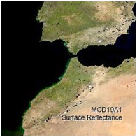
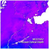
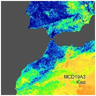
New Version 6 Terra and Aqua Combined MODIS Multi-Angle Implementation of Atmospheric Correction (MAIAC) #data available from the NASA LP DAAC! Products include spectral BRF #surfacereflectance, #AOD, #BRDF #remotesensing. Learn more: bit.ly/2sQ8QVv
RT @davidvhill: #Landsat #SurfaceReflectance looks good! bit.ly/WIfT9k Lots of images @ GloVis under GLS. glovis.usgs.gov

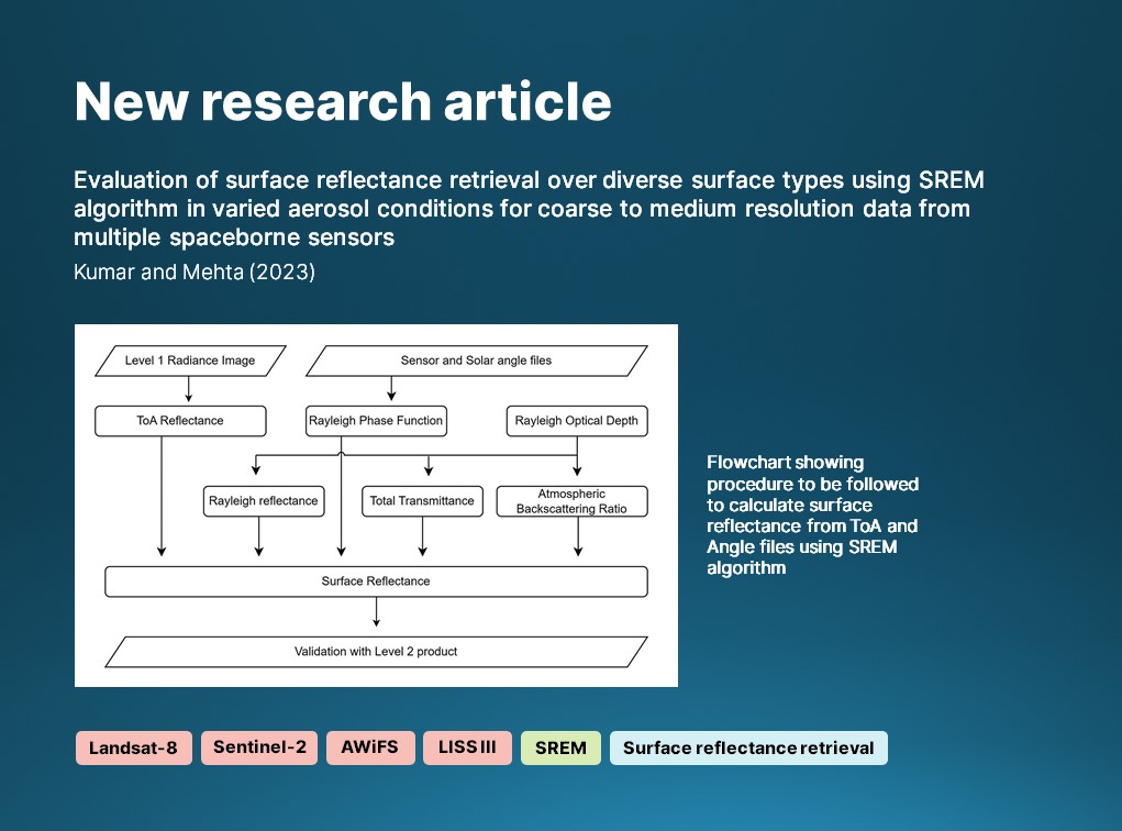
🔔 New article: Kumar & Mehta assess the accuracy of a robust #SurfaceReflectance estimation method (#SREM) over various Indian #LandSurface types using data from 🛰️ #Landsat8, #Sentinel2, #AWiFS and LISS III. 🔗 doi.org/10.1080/014311… #IJRS #RemoteSensing #optical
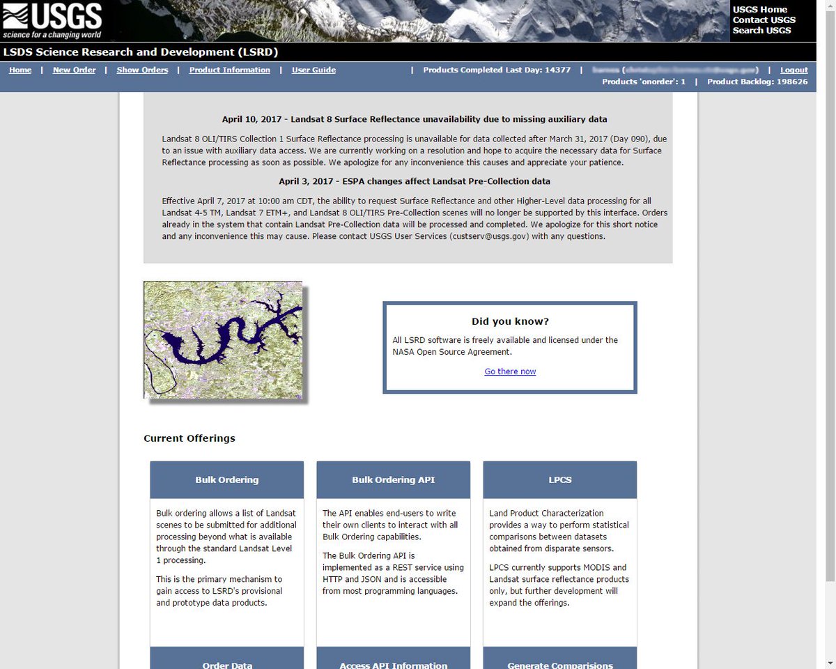
EROS Science Processing Architecture (#ESPA) Notice: #Landsat 8 #surfacereflectance unavailability due to missing auxiliary data.

The CHRIS instrument onboard #Proba1 ESA mission is aloft since Oct 2001, acquiring 17 to 34m resolution data at 5 different viewing angles; a CHRIS Toolbox is now available for #SNAP with updated features to convert CHRIS data to #SurfaceReflectance. See: bit.ly/39E3Wlf
A new option for MODIS #surfacereflectance data!
New Version 6 Terra and Aqua Combined MODIS Multi-Angle Implementation of Atmospheric Correction (MAIAC) #data available from the NASA LP DAAC! Products include spectral BRF #surfacereflectance, #AOD, #BRDF #remotesensing. Learn more: bit.ly/2sQ8QVv

A DEEP LEARNING MODEL FOR ATMOSPHERIC CORRECTION OF SATELLITE IMAGES #TechRxiv #atmosphericcorrection #surfacereflectance #deeplearning #remotesensing techrxiv.org/articles/prepr…

DN, #SurfaceReflectance and Radiance: the differences and why they are important to #imagery analysis exelisvis.com/Company/PressR…

RT @asoconnor: DN, #SurfaceReflectance and Radiance: the differences and why they are important to #imagery analysis exelisvis.com/Company/PressR…

Migrating our little subsetting tool to access heaps more #surfaceReflectance and #fractionalCover data across Aust vegcover.com/chopper/index2…
Did you know that the USGS provides research-quality, applications-ready #Landsat science products? Level-2 scene-based science products include #SurfaceReflectance, #SurfaceTemperature, #SpectralIndices, and Provisional #AquaticReflectance. More here: ow.ly/VNAM50VgboZ
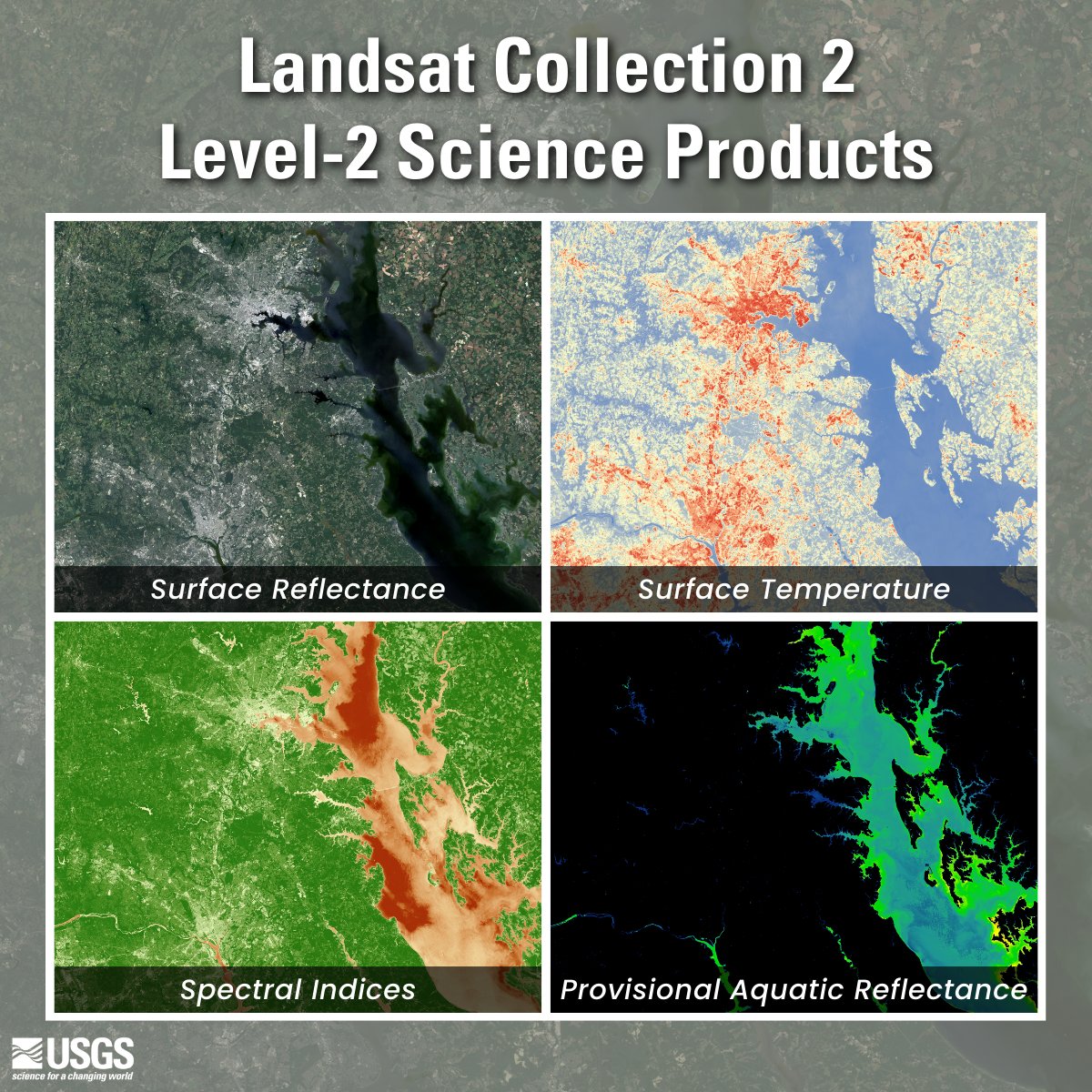
Did you know that the USGS provides research-quality, applications-ready #Landsat science products? Level-2 scene-based science products include #SurfaceReflectance, #SurfaceTemperature, #SpectralIndices, and Provisional #AquaticReflectance. More here: ow.ly/TQo450UOPIg
🌊🛰️👉 Quantitative Retrieval of #Chlorophyll-a Concentrations in the Bohai–Yellow Sea Using #GOCI #SurfaceReflectance Products ✍️ Jiru Wang et al. 📎 brnw.ch/21wNuwA
A simple Vegetation change detection of an area around Mt. Elgon, using @DEarthAfrica #DEAfricaSandbox #Landsat8 #surfacereflectance product, comparing two different times. Red areas show a negative change while blue ones a positive change. @kenmubea @ZvikoDM @JosephTUYISHIMI
🔔 New article: Kumar & Mehta assess the accuracy of a robust #SurfaceReflectance estimation method (#SREM) over various Indian #LandSurface types using data from 🛰️ #Landsat8, #Sentinel2, #AWiFS and LISS III. 🔗 doi.org/10.1080/014311… #IJRS #RemoteSensing #optical
A DEEP LEARNING MODEL FOR ATMOSPHERIC CORRECTION OF SATELLITE IMAGES #TechRxiv #atmosphericcorrection #surfacereflectance #deeplearning #remotesensing techrxiv.org/articles/prepr…
#RSHighlyCitedPaper A Simplified and Robust #SurfaceReflectance Estimation Method (#SREM) for Use over Diverse #LandSurfaces Using #MultiSensor Data By Muhammad Bilal, Majid Nazeer, et al. 👉mdpi.com/2072-4292/11/1… #remotesensing #Landsat #satellite #LEDAPS #LaSRC #SREM #NDVI
Atmospheric Correction Inter-Comparison Exercise by Georgia Doxani, Eric Vermote, et al. 2018 👉mdpi.com/2072-4292/10/2… #remotesensing #atmosphericcorrection #surfacereflectance #aerosolopticalthickness #watervapour #Sentinel2 #Landsat8
#OTD in 1987 @BlackHillsNF was established. The forest is surrounded by grasslands and agriculture as seen in this #Landsat8 #SurfaceReflectance image mosaic.
A new option for MODIS #surfacereflectance data!
New Version 6 Terra and Aqua Combined MODIS Multi-Angle Implementation of Atmospheric Correction (MAIAC) #data available from the NASA LP DAAC! Products include spectral BRF #surfacereflectance, #AOD, #BRDF #remotesensing. Learn more: bit.ly/2sQ8QVv
New Version 6 Terra and Aqua Combined MODIS Multi-Angle Implementation of Atmospheric Correction (MAIAC) #data available from the NASA LP DAAC! Products include spectral BRF #surfacereflectance, #AOD, #BRDF #remotesensing. Learn more: bit.ly/2sQ8QVv
#LandsatHeadline: #LandsatCollection1 #surfacereflectance ordering through #EarthExplorer is now available. on.doi.gov/2oMU6pN
You can now order #Landsat #surfacereflectance from #EarthExplorer. earthexplorer.usgs.gov For more information see on.doi.gov/2oHdi8u
EROS Science Processing Architecture (#ESPA) Notice: #Landsat 8 #surfacereflectance unavailability due to missing auxiliary data.
Migrating our little subsetting tool to access heaps more #surfaceReflectance and #fractionalCover data across Aust vegcover.com/chopper/index2…
#LandsatHeadline: #LandsatCollection1 #surfacereflectance ordering through #EarthExplorer is now available. on.doi.gov/2oMU6pN
Atmospheric Correction Inter-Comparison Exercise by Georgia Doxani, Eric Vermote, et al. 2018 👉mdpi.com/2072-4292/10/2… #remotesensing #atmosphericcorrection #surfacereflectance #aerosolopticalthickness #watervapour #Sentinel2 #Landsat8
#RSHighlyCitedPaper A Simplified and Robust #SurfaceReflectance Estimation Method (#SREM) for Use over Diverse #LandSurfaces Using #MultiSensor Data By Muhammad Bilal, Majid Nazeer, et al. 👉mdpi.com/2072-4292/11/1… #remotesensing #Landsat #satellite #LEDAPS #LaSRC #SREM #NDVI
You can now order #Landsat #surfacereflectance from #EarthExplorer. earthexplorer.usgs.gov For more information see on.doi.gov/2oHdi8u
#OTD in 1987 @BlackHillsNF was established. The forest is surrounded by grasslands and agriculture as seen in this #Landsat8 #SurfaceReflectance image mosaic.
Did you know that the USGS provides research-quality, applications-ready #Landsat science products? Level-2 scene-based science products include #SurfaceReflectance, #SurfaceTemperature, #SpectralIndices, and Provisional #AquaticReflectance. More here: ow.ly/TQo450UOPIg
A simple Vegetation change detection of an area around Mt. Elgon, using @DEarthAfrica #DEAfricaSandbox #Landsat8 #surfacereflectance product, comparing two different times. Red areas show a negative change while blue ones a positive change. @kenmubea @ZvikoDM @JosephTUYISHIMI
EROS Science Processing Architecture (#ESPA) Notice: #Landsat 8 #surfacereflectance unavailability due to missing auxiliary data.
New Version 6 Terra and Aqua Combined MODIS Multi-Angle Implementation of Atmospheric Correction (MAIAC) #data available from the NASA LP DAAC! Products include spectral BRF #surfacereflectance, #AOD, #BRDF #remotesensing. Learn more: bit.ly/2sQ8QVv
RT @davidvhill: #Landsat #SurfaceReflectance looks good! bit.ly/WIfT9k Lots of images @ GloVis under GLS. glovis.usgs.gov
🌊🛰️👉 Quantitative Retrieval of #Chlorophyll-a Concentrations in the Bohai–Yellow Sea Using #GOCI #SurfaceReflectance Products ✍️ Jiru Wang et al. 📎 brnw.ch/21wNuwA
🔔 New article: Kumar & Mehta assess the accuracy of a robust #SurfaceReflectance estimation method (#SREM) over various Indian #LandSurface types using data from 🛰️ #Landsat8, #Sentinel2, #AWiFS and LISS III. 🔗 doi.org/10.1080/014311… #IJRS #RemoteSensing #optical
The CHRIS instrument onboard #Proba1 ESA mission is aloft since Oct 2001, acquiring 17 to 34m resolution data at 5 different viewing angles; a CHRIS Toolbox is now available for #SNAP with updated features to convert CHRIS data to #SurfaceReflectance. See: bit.ly/39E3Wlf
Something went wrong.
Something went wrong.
United States Trends
- 1. #GivingTuesday 23.9K posts
- 2. #twitchrecap 6,276 posts
- 3. Larry 35.9K posts
- 4. Jared Curtis 2,588 posts
- 5. Costco 49K posts
- 6. #AppleMusicReplay 8,439 posts
- 7. #DragRace 5,040 posts
- 8. So 79% 1,322 posts
- 9. Susan Dell 5,813 posts
- 10. NextNRG Inc. 2,838 posts
- 11. #csm222 7,094 posts
- 12. BT and Sal N/A
- 13. Cabinet 53.2K posts
- 14. Carton 29.4K posts
- 15. WFAN N/A
- 16. Lucario 25.9K posts
- 17. Punk and AJ 1,972 posts
- 18. King Von 1,712 posts
- 19. $BBAI 2,491 posts
- 20. Trump Accounts 12.7K posts