#webmaps search results

Our "ant path" tutorial demonstrates how to animate and change color along a route. This type of animation is perfect to show a newly selected route or a live route. It also means you can change color dynamically! Play with it: buff.ly/3ndZym8 #webmaps #webdeveloper

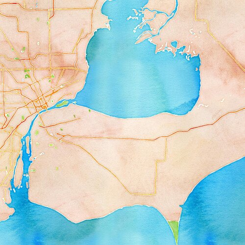
Have you seen our Aquarelle #map style yet? Add a splash of color and creativity to your #webmaps and apps! 🎨
For #mondaymapday, let's go to Tokyo! 🗼 Check out this real-time 3D digital map of Tokyo's public transport system, produced by Akihiko Kusanagi: buff.ly/3elFCHh #builtwithmapbox #webmaps #transportation

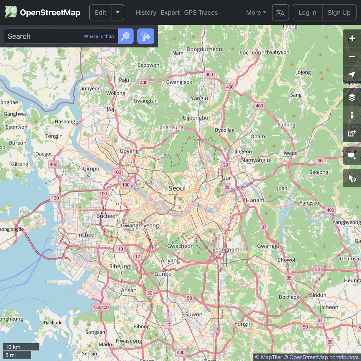
We're supporting the @openstreetmap community by providing a new map layer for their website. Thanks to #VectorTiles technology, you can now read map labels in your own language, no matter what part of the world you are looking at! maptiler.link/452oQ8W #WebMaps #OpenStreetMap


More fun with FreeCameraOptions! Choose to move the camera in a fly-over animation about any point on earth to create stunning visuals: buff.ly/3FP5yIm #3Dmaps #mapping #webmaps

Lat/lon → screen pixels 🎯 This starter shows how to use map.project() in MapLibre to track mouse coords and place overlays precisely. Demo 👉 codepen.io/geoapify/pen/x… #MapLibre #WebMaps #Geoapify

Generate tiles directly from your database using #PostGIS`s ST_AsMVT and ST_AsMVTGeom functions. Connecting to the database via the intuitive GUI in MapTiler Server is really easy too. (Advanced users can still use SQL if they want!) Learn more: bit.ly/4arUpuu #WebMaps
Upload spatial raster files directly to MapTiler Cloud! We’re making it easy to add your GIS data to web maps; try one of these key formats: GeoTIFF, GeoJPEG2000, MrSID, ECW. Find out more here: maptiler.link/3BkKVnW #webmaps #webmapping
Go global with the MapTiler SDK! Find out just how easy it is to add a 3D globe to a website or app! #JavaScript #TypeScript #WebMaps #WebGL #Globe

Making an interactive map with global data? Try out globe view with a custom style to make your map really stand out! Map credit @spatialnodehq. Documentation at buff.ly/3YAfKgb 🌍 #interactivemaps #mapdesign #webmaps
The easiest-to-use cartography tool on the web! Martin Elias shared all the details about the @MapTiler map designer at #Connect25, explaining why it’s so intuitive. Find out what it can do; the link is in the first reply. #WebMaps #Cartography #Maps


Turn your flat map into a globe with a single line of code! The MapTiler SDK makes it so easy to display maps on a 3D planet, just as nature intended! #JavaScript #TypeScript #WebMaps #WebGL
3D Globe maps using a JavaScript SDK! Show your maps on a 3D globe with a single line of code! #WebMaps #Globe #WebGL


Don't forget to invite your friends and colleagues who share the same passion for maps on the web. Send links to your videos, including short or longer descriptions, to [email protected]. #internetICA #webmaps #icaci

Make your maps respond to user input: in this classic example, bounded areas respond to being hovered over by the mouse. What else can you do with the hover effect? Experiment using GL JS: buff.ly/3TGkHSa #webmaps #webdeveloper
Mapbox Styles aren't just elegant, they're also customizable by both devs and end users. Here, the Mapbox Light style is re-rendered with an embedded menu, letting the user choose how to view the map. Learn how to make this: buff.ly/40domZX #mapdesign #webmaps
Make a map style dynamic with an 'interpolate' expression. 💡 In this example, the color and opacity of buildings change in response to the map's zoom. Try the same with roads, rivers, or ranches with help from our Docs: buff.ly/3nlRxLZ #devtips #webmaps

Google sued for negligence after man drove off collapsed bridge while following map directions apnews.com/article/google… #webmaps Lawsuit smbb.com/wp-content/upl… + press release smbb.com/news-article/l… 'Bridge to Nowhere' in Hickory, North Carolina collapsed nine years ago.


Learn how to enhance Oracle Analytics with tiled web map backgrounds in this blog post: social.ora.cl/6015354md #WebMaps
Learn about the map designer and how to customize your maps here: maptiler.link/47JiBs8 #WebMaps #Maps# Cartography

The easiest-to-use cartography tool on the web! Martin Elias shared all the details about the @MapTiler map designer at #Connect25, explaining why it’s so intuitive. Find out what it can do; the link is in the first reply. #WebMaps #Cartography #Maps

Before rewriting your GIS stack, try this: → Cache tiles → Compress GeoJSON → Offload heavy ops to PostGIS Most GIS issues are architecture, not tools. #GIS #webmaps
Lat/lon → screen pixels 🎯 This starter shows how to use map.project() in MapLibre to track mouse coords and place overlays precisely. Demo 👉 codepen.io/geoapify/pen/x… #MapLibre #WebMaps #Geoapify
⭐ Use Font Awesome with Marker Icons API! Thousands of icons, fully customizable in size, color, shadow & more for your maps. Just set: iconType=awesome&icon=star #mapdesign #webmaps #leafletjs #fontawesome #gisdev #maplibre 👉 geoapify.com/map-marker-ico…

✨ Use beautiful custom map markers in your Static Maps! Generate icons with Font Awesome, Material, or Lucide Add to map via marker param → Done! Try it: geoapify.com/static-maps-ap… #staticmaps #mapmarkers #webmaps #gisdev #leafletjs #maplibre #mapdesign

We're supporting the @openstreetmap community by providing a new map layer for their website. Thanks to #VectorTiles technology, you can now read map labels in your own language, no matter what part of the world you are looking at! maptiler.link/452oQ8W #WebMaps #OpenStreetMap
🌍 Want to get an address when a user clicks on a map? This JavaScript tutorial combines Geoapify Reverse Geocoding API + Leaflet + JSFiddle to show addresses in real time. geoapify.com/tutorial/rever… #javascript #gis #webmaps #jsfiddle
geoapify.com
Reverse Geocoding Javascript Tutorial | Geoapify
This Javascript tutorial explains how to use Reverse Geocoding API to get an address by latitude/longitude coordinates. We've prepared JSFiddle and a live demo to help you integrate the API.
Which map library should you use in 2025? We compare Leaflet, MapLibre GL & OpenLayers → geoapify.com/map-libraries-… #webmaps #gis @LeafletJS @maplibre @openlayers #Frontend #JavaScript #WebDev
geoapify.com
Map libraries popularity: Leaflet vs MapLibre GL vs OpenLayers
Explore the popularity of Leaflet, MapLibre GL, and OpenLayers through npm downloads and Google search trends.

Two days to go! Come along to find out more about generating simple web maps and meet our new Account Manager! Save your place: bit.ly/AstunSpotlight #PublicSector #Webmaps
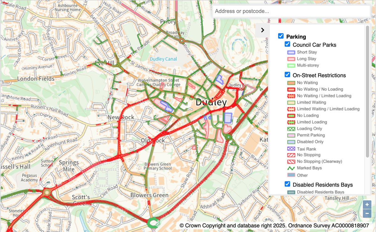
⏰ ONE WEEK TO GO! Want to use web maps to share info about your council? Join our "Generating Simple Web Maps with Spotlight" webinar! Learn to make maps with iShare in the Cloud's Spotlight add-on, just like Dudley MBC! 📅 April 16th, 11 am 📍 Online Register:…
Highlight the global nature of your data, like undersea cables, by putting them on an actual globe! #JavaScript #TypeScript #WebMaps #WebGL #Globe

Animate flight paths with a 3D plane on a globe using the MapTiler SDK! #JavaScript #TypeScript #WebMaps #WebGL #Globe

We are bringing you a fully customizable globe and sky to add to your #webmaps and apps! Try the new Sky and Light styling properties on our globe #maps; currently in beta, they will be improved over the coming months. Find out more on our blog; the link is in the comments.

Check out our code examples to get started: maptiler.link/4aqu8xv #JavaScript #TypeScript #WebMaps #WebGL #Globe


For #mondaymapday, let's go to Tokyo! 🗼 Check out this real-time 3D digital map of Tokyo's public transport system, produced by Akihiko Kusanagi: buff.ly/3elFCHh #builtwithmapbox #webmaps #transportation
Place a 3D model on a map using threebox by @jscastro76. This Mapbox GL JS plugin makes adding 3D objects with three.js simpler than ever! Learn to use it with our example released just this Monday: buff.ly/44fln5I #webmaps #developers #devtips

Go global with the MapTiler SDK! Find out just how easy it is to add a 3D globe to a website or app! #JavaScript #TypeScript #WebMaps #WebGL #Globe
Add ocean floor detail to your maps as depth polygons, contour lines, and even underwater hill shading! Available for your #webmaps and apps, and in GIS software too. Find out how to use MapTiler Ocean here: ow.ly/AGwT50MPuJJ

We're supporting the @openstreetmap community by providing a new map layer for their website. Thanks to #VectorTiles technology, you can now read map labels in your own language, no matter what part of the world you are looking at! maptiler.link/452oQ8W #WebMaps #OpenStreetMap
Mapbox GL JS lets Mapster WP Maps enable fast and easy custom map integration for WordPress websites. Learn how Mapster built a multi-purpose plugin for WordPress users with Mapbox: buff.ly/2ZhwT1u #BuiltWithMapbox #webmaps #mapping

Did you know you can use third-party map tile sources in your GL JS maps? Learn how to connect a raster tile source to your map with this example code: buff.ly/44loYyC (Tiles by @stamen) #mapping #webmaps

Upload #GeoTIFFs to MapTiler Cloud and use them directly in your #Webmaps! Find out how: maptiler.link/4e8QGDH

Hello #SIGLibre2024! Wladimir (@bolosig) is looking forward to speaking to people about #webmaps and more. Make sure you see his presentation on building webmaps with MapTiler SDK and MapLibre tomorrow in the Graus Room, 10:20-10:45! #SIG #GIS @SIGLibreGirona @SIGTE_UdG

Mapbox GL JS equips Mapster to build the leading WordPress mapping plugin. 🏆 See how Mapster helps WP users to seamlessly enrich their websites with modern interactive maps: buff.ly/2ZhwT1u #wordpress #webmaps #builtwithmapbox

Our maps are fast because they are made with vector tiles.⚡ But you can still add raster layers! This example from our GL JS Docs shows how to display a raster image of weather data: buff.ly/3JfiLuV (notice how restricting zoom is advisable💡) #devtips #webmaps

3D Globe maps using a JavaScript SDK! Show your maps on a 3D globe with a single line of code! #WebMaps #Globe #WebGL
Strategic creative agency @studiomade built their new EV road trip city guides with Mapbox for maximum design flexibility and performance. Get inspired by these beautiful interactive guides at nissantravelguide.com #design #designagency #webmaps

Another week, another new Docs example! Understand the simple but effective feature of a dynamic map scale bar in Mapbox GL JS with the ScaleControl 📏. Give it a try: buff.ly/3W5z1oo #webmaps

Animate flight paths with a 3D plane on a globe using the MapTiler SDK! #JavaScript #TypeScript #WebMaps #WebGL #Globe
The map by @ClimateTRACE is a great example of the Equal Earth adaptive projection in action. Check it out and learn more about global emissions data: buff.ly/41hkkjP #mapdesign #cartography #webmaps

Enhance your #webmaps with high-resolution map tiles generated from your own raster data using MapTiler Engine. Try it for free: bit.ly/44NeKYW

You can display data of any precision with Mapbox - from global to street level. 🌍 If data is best viewed at a particular zoom range, then learn from this GL JS example how to restrict zoom range for optimal viewing: buff.ly/3JfiLuV #devtips #mapdesign #webmaps

We love maps that get into the Halloween spirit! 🎃 The Royal Wharf development organized a Halloween trick-or-treat trail and they built a special map using the 'night' view of our new 3D Mapbox Standard style. Spooktacular! 👻 #builtwithmapbox #webmaps

Cloudy with a chance of maps! 🌦️ Weather maps get a ton of exposure and need to perform under pressure. See how the weather industry is modernizing mapping with Mapbox: buff.ly/3JNcVlS #webmaps #dataviz

Something went wrong.
Something went wrong.
United States Trends
- 1. #DWTS 45.7K posts
- 2. Northern Lights 23.8K posts
- 3. #Aurora 4,889 posts
- 4. Justin Edwards 1,637 posts
- 5. Louisville 14.5K posts
- 6. Andy 58.8K posts
- 7. Lowe 11.9K posts
- 8. Elaine 41.9K posts
- 9. #RHOSLC 5,413 posts
- 10. Kentucky 23.4K posts
- 11. #OlandriaxHarpersBazaar 2,397 posts
- 12. Celtics 11.3K posts
- 13. Oweh 1,686 posts
- 14. Robert 100K posts
- 15. JT Toppin N/A
- 16. #WWENXT 15K posts
- 17. Dylan 31.3K posts
- 18. Jordan Walsh N/A
- 19. Whitney 8,534 posts
- 20. Kam Williams N/A