#cyclonefina search results

Tropical Cyclone Fina is the earliest cyclone on record to hit the NT. It’s not even summer! Hotter oceans are supercharging storms like #CycloneFina. This is a preview. Cut fossil fuels or brace for worse. #auspol #ClimateActionNow abc.net.au/news/2025-11-2…


Tropical #CycloneFina doing some rebuilding on Thursday. Consolidation is expected on Friday, with a return to category 2 intensity.

Cyclone Fina has intensified into a category three storm, as of 9:30am. Darwin residents are advised to take shelter as the storm brings heavy rain, strong winds, and flash flooding. #CycloneFina #storm #rain #flashfloods #Darwin
Convection associated with Tropical #CycloneFina. The system may be over Van Diemen Gulf, north east of Darwin, by Saturday. bom.gov.au/warning/tropic…

Tropical #CycloneFina, now a category 1 system, has formed north of #Darwin and is moving slowly to the east north-east and strengthening. Later this week it is expected to turn towards the #NT coast. Latest Track Map: ow.ly/RgNZ50XtKKK
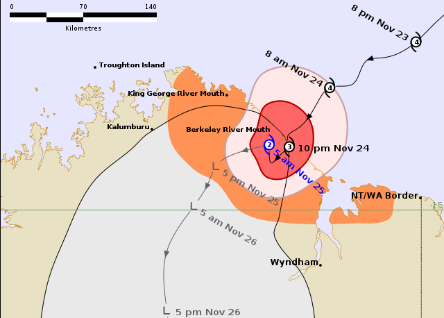
In satellite imagery, Severe Tropical #CycloneFina's eye feature has tended to be obscured by cirrus. It's a bit more apparent on Monday morning, as the system approaches the northeast Kimberley coast.
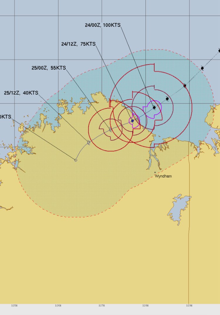
Latest projections from BOM ACCESS-C and ECMWF HRES for Severe Tropical #CycloneFina. Both already a little off the mark; ACCESS closer. Official forecast track at bom.gov.au/warning/tropic….
Severe Tropical #CycloneFina - now category 3 - over Van Diemen Gulf, north east of Darwin. bom.gov.au/warning/tropic…

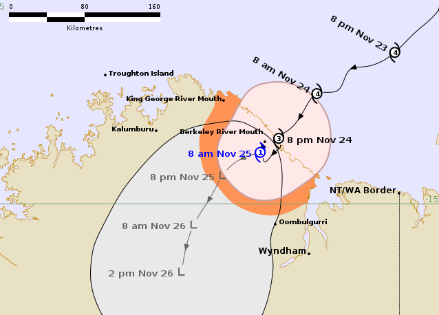
Tropical #CycloneFina crossed the Cobourg Peninsula overnight as a Category 2 system and is now over the Van Diemen Gulf, heading southwest and strengthening. As of 7.33am ACST, #TCFina is a Category 3 cyclone. weatherzone.com.au/news/tropical-…
Tropical #CycloneFina's journey across the Cobourg Peninsula, over Melville Island and Van Diemen Gulf, past Darwin, and south west towards Joseph Bonaparte Gulf.

“We do not want to alarm Territorians, but… Blackouts are a possibility” #CycloneFina damaged an offshore gas project and now Darwin faces potentially blackouts! Also on today’s show I speak to @johncoyne14 about NT fuel supplies ⛽️ abc.net.au/listen/program…
abc.net.au
NT Country Hour - ABC listen
Blacktip offshore gas project damaged during Cyclone Fina and could lead to power blackouts in the Top End. Is Darwin's limited diesel storage 'putting industry at risk'?

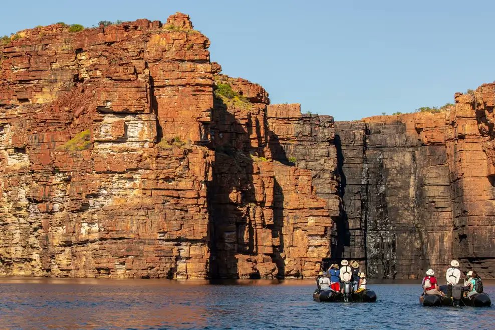
Berkeley River Lodge Caretakers Survived 'Apocalyptic' Cyclone Fina In Underground Bunker 🌀 #CycloneFina #Kimberley #PerthNews #TCFina #WesternAustralia abc.net.au/news/2025-11-2…
abc.net.au
Caretakers huddled in bunker as ‘apocalyptic’ Cyclone Fina hit luxury lodge
Laura Stokes and Adam Zerna describe spending time in an underground bunker as the category three cyclone passed over, before emerging to find an "apocalyptic" scene.
Imagine having a few thousand head of cattle and buffalo in yards… and a Cat3 cyclone is headed your way!! 🌀🐂🐃 Great catching up with Ben @ the Berrimah Export Yards today 🎙️ abc.net.au/listen/program… #CycloneFina #LiveExport

🌀#CycloneFina has gone 🐂Top End export yards are full 🚢and live export ships are lining up to get cattle & buffalo out of Darwin port #LIVEXchange abc.net.au/listen/program… @AustLiveExports @AusLiveCorp @troysetter @NTLEA

Canada issues urgent travel advisory for Australia Read more about it👇 plplnews.com/canada-issues-… #CanadaTravelAdvisory #CycloneFina #AustraliaWeather #TropicalCyclone #TravelSafety #CanadaAlerts #BureauOfMeteorology #SevereWeather #FlashFlooding #LandslideRisk
Wyndham Has Also Beaten Their November Record For Their Lowest Daily Maximum Temperature Yesterday Reaching A Top Of 26.8 Degrees, The Previous Record Was 29.8 Degrees On The 8th Of November 2007 🥶 #CycloneFina #Kimberley #TCFina #WesternAustralia
The 147.2mm Of Rain Recorded In The 24 Hours To 9:00am At Wyndham Today Has Also Broken The Daily Record For November Which Was 84.0mm Recorded On The 13th Of November 2001🪣 #CycloneFina #Kimberley #TCFina #WesternAustralia x.com/weather_wa/sta…
Wyndham Recorded 147.2mm Bringing Their Monthly Total Up To 291.8mm Which Is 234.2mm Above Their 57.6mm Average And Beating Their All Time November Record Of 162.0mm Recorded In 2001 By 129.8mm Plus Another 0.2mm Since 9:00am 🪣 #CycloneFina #Kimberley #TCFina #WesternAustralia
Wyndham Recorded 147.2mm Bringing Their Monthly Total Up To 291.8mm Which Is 234.2mm Above Their 57.6mm Average And Beating Their All Time November Record Of 162.0mm Recorded In 2001 By 129.8mm Plus Another 0.2mm Since 9:00am 🪣 #CycloneFina #Kimberley #TCFina #WesternAustralia

Luxury tourism resort Berkeley River Lodge suffers 'significant damage' in #CycloneFina direct hit abc.net.au/news/2025-11-2…
abc.net.au
Luxury WA resort suffers severe damage after Ex-Tropical Cyclone Fina's direct hit
A luxury wilderness resort only accessible by sea and air has been significantly damaged in a direct hit from Ex-Tropical Cyclone Fina, which made landfall in an extremely remote part of WA.
#PODCAST 🍌 #CycloneFina damage to NT’s largest banana farm 💧Mataranka Water Plan in the Supreme Court 🌦️ New BoM boss explains new website 🚁 Who bought the fleet of R22s? abc.net.au/listen/program…
abc.net.au
NT Country Hour - ABC listen
The NT's largest banana farm assessing the damage after Cyclone Fina. Darwin Port reopens after cyclone closure.

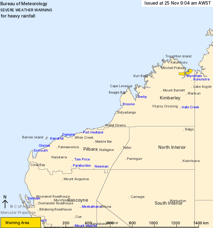
⚠️🌧️ 11:30am: Severe Weather Warning for heavy #rainfall in parts of the Kimberley District. Heavy rainfall possible in rain bands to the south and southeast of Tropical #CycloneFina, easing Wednesday morning. May impact #Wyndham. Details: bom.gov.au/warning/severe…

#Cyclone Fina Has Now Been Downgraded To A Category 1 System And Is Continuing To Weaken As It Moves Further Inland 🌀 A Severe Weather Warning For Heavy Rainfall Has Been Issued For Parts Of The Kimberley Region ⚠️ #CycloneFina #Kimberley #TCFina #WesternAustralia
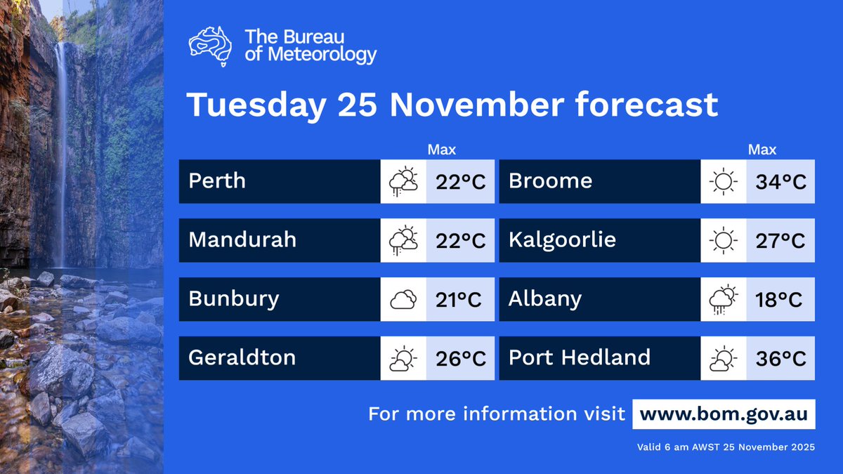
Today's forecast for #WA: Tropical #CycloneFina will bring heavy rain and damaging winds to the northern Kimberley, weakening through the day. Storms for remaining northern areas, possible showers in the south-west, including #Perth. Latest: bom.gov.au
#Cyclone Fina Has Now Been Downgraded To A Category 2 System And Is Continuing To Make It's Way Over The Kimberley Region 🌀 #CycloneFina #Kimberley #TCFina #WesternAustralia

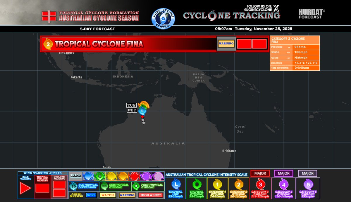
#CycloneFina Advisory 22 Winds: 100mph BOM: C2 MSLP: 965mb #Fina weakens to a Category 2 cyclone as it moves over the Mount Booton, Kimberly, with some strong and damaging winds, heavy rainfall, and flash flooding along parts of Mount Booton...


Tropical #CycloneFina is impacting the #NT overnight Saturday and into Sunday. View the latest track map: bom.gov.au/warning/tropic… Latest warnings: bom.gov.au/weather-and-cl…

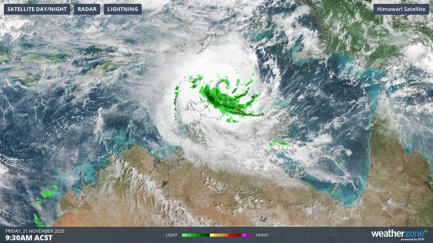
Tropical #CycloneFina is set to become the first category 3 cyclone in Australian waters in November since Cyclone Bertie-Alvin in 2005, and it could happen as early as Friday evening. 📷 This image shows cloud and rainfall associated with #TCFina at 9:30am ACST on Friday.

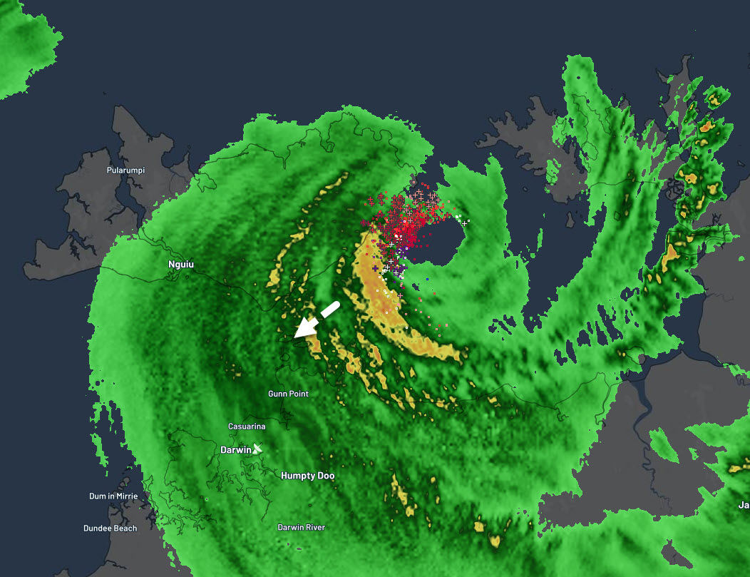
Oz tropical #CycloneFina a severe cat 3, made an initial landfall on N.T's Cobourg Peninsula this morning as a cat 2 and has re-intensified over Van Diem Gulf in a low wind shear environment. Intense inner eyewall lightning is present in this strengthening phase, with a familiar
Stay up to date with the latest advice and warnings as Tropical #CycloneFina continues to impact the #NorthernTerritory. Latest track map: bom.gov.au/warning/tropic… Latest warnings: bom.gov.au/weather-and-cl…


#CycloneFina kicks off the Australian Cyclone Season, and is developing to the north of Darwin in the Northern Territory. Latest: youtube.com/watch?v=sNAEdj…

Warnings in place for #CycloneFina as it closes in on the Northern Territory of Australia Video: youtube.com/watch?v=LbefFs…


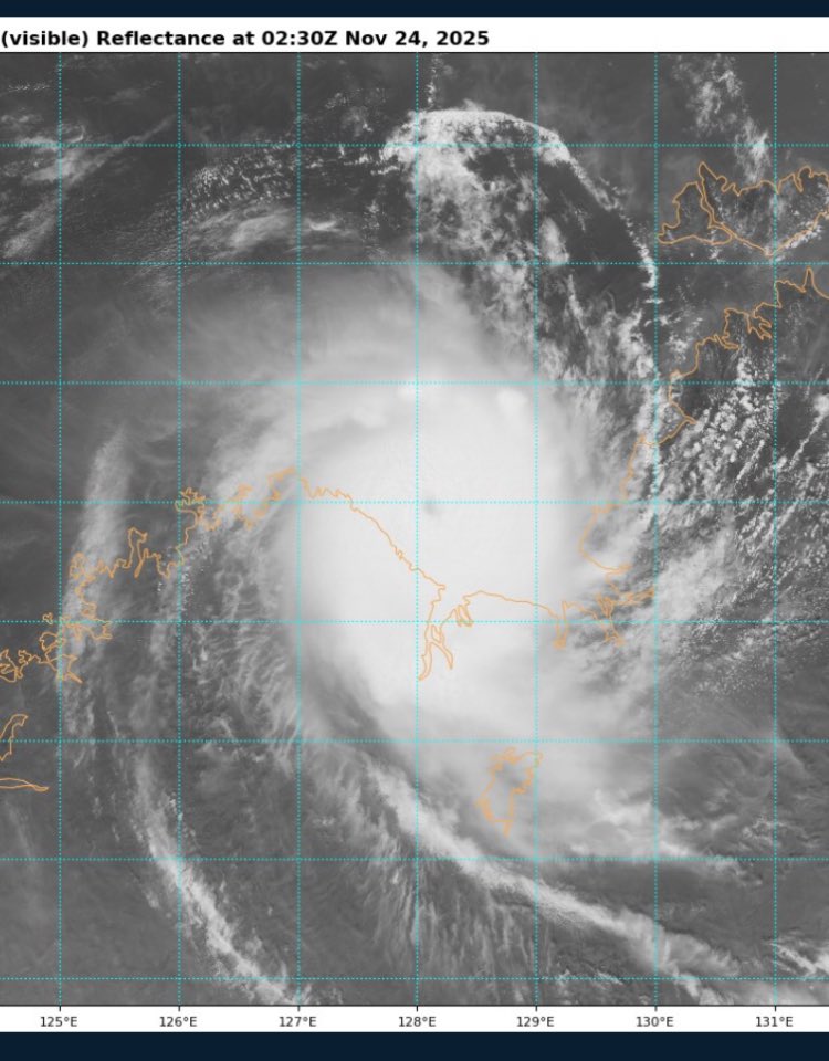
🌀🦘Severe Tropical #CycloneFina has intensified into a Category 4️⃣ system, moving south-west towards the northeast Kimberley coast. The storm is out over the Timor Sea.


#CycloneFina continues to slowly gather strength near Darwin, Australia. 🌀 Winds now at 80 knots with the central pressure down to 974 mb.

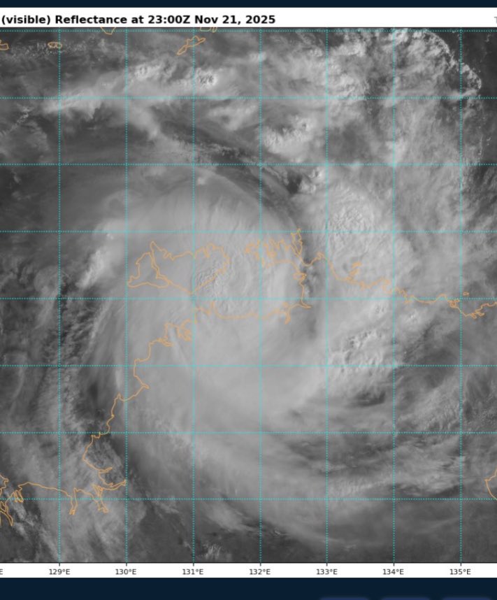
Tropical Cyclone #FINA As of 18:00 UTC Nov 21, 2025: Location: 11.7°S - 131.8°E Maximum Winds: 70 kt Gusts: N/A Minimum Central Pressure: 979 mb Environmental Pressure: N/A Radius of Circulation: N/A Radius of Maximum wind: 50 nm via: Tropicaltidbits . com
Today's forecast for #WA: Tropical #CycloneFina will bring heavy rain and damaging winds to the northern Kimberley, weakening through the day. Storms for remaining northern areas, possible showers in the south-west, including #Perth. Latest: bom.gov.au
Something went wrong.
Something went wrong.
United States Trends
- 1. #LakeShow N/A
- 2. #SmackDown N/A
- 3. RJ Barrett N/A
- 4. Toronto N/A
- 5. Magic N/A
- 6. McAvoy N/A
- 7. Sengun N/A
- 8. Cavs N/A
- 9. #ForgedInGold N/A
- 10. Game 7 N/A
- 11. Amen Thompson N/A
- 12. #OPLive N/A
- 13. Lakers in 7 N/A
- 14. Benson N/A
- 15. Mobley N/A
- 16. Raptors N/A
- 17. Thunder in 4 N/A
- 18. Pistons N/A
- 19. Bruins N/A
- 20. Reed Sheppard N/A