#geospatialtech search results

Geospatial tech is transforming EUDR compliance. Manual data management is still too time-consuming and unscalable. Learn about scalable EUDR compliance in our recent webinar. hubs.la/Q03SsdkK0 #EUDR #Sustainability #GeospatialTech #Compliance
Ms. Tania D’Cunha, Project Manager at Fluxatic Global, shares how attending the 16th edition of First Fridays gave her new insights into the role of geospatial technology in our daily lives #BuildInGoa #EmpoweredInGoa #GeospatialTech #CreativeCommunityofGoa
Congrats to Alexander Arnold (M.S. Integrated Geospatial Tech, advised by Dr. Jae Sung Kim) for presenting “An Application of Neural Radiance Fields for Visualizing Mars Perseverance Rover Data” at #ASPRS2025! 🌍 🔗 community.asprs.org/2025symposium/… #GeospatialTech #MTUresearch

“From atoms to the universe , geospatial tech is reshaping how we see, understand and innovate"🚀 #BuildInGoa #EmpoweredInGoa #GeospatialTech #CreativeCommunityofGoa

Our experience with various stakeholders highlights an important observation: #Africa needs #GeospatialTech #Data #Innovations rooted in local realities, guided by on-the-ground data, created to transform. Ready to co-create useful innovation? Contact us: africangeospace.com/contact

Maps have evolved, and so has innovation🗺️📍 #GeospatialTech #InnovationInGoa #BuildInGoa #EmpoweredInGoa


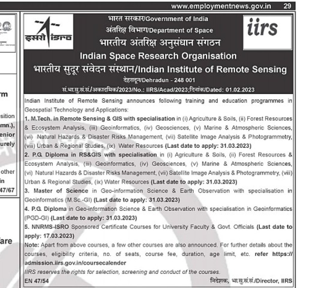
🌎🛰️ Ready to explore the world from a new perspective? Indian Institute of Remote Sensing, #ISRO, is now accepting applications for Geospatial Technology and Applications training programs! Interested candidates may apply by March 31st! 🚀 @isro #GeospatialTech #ExploreTheWorld

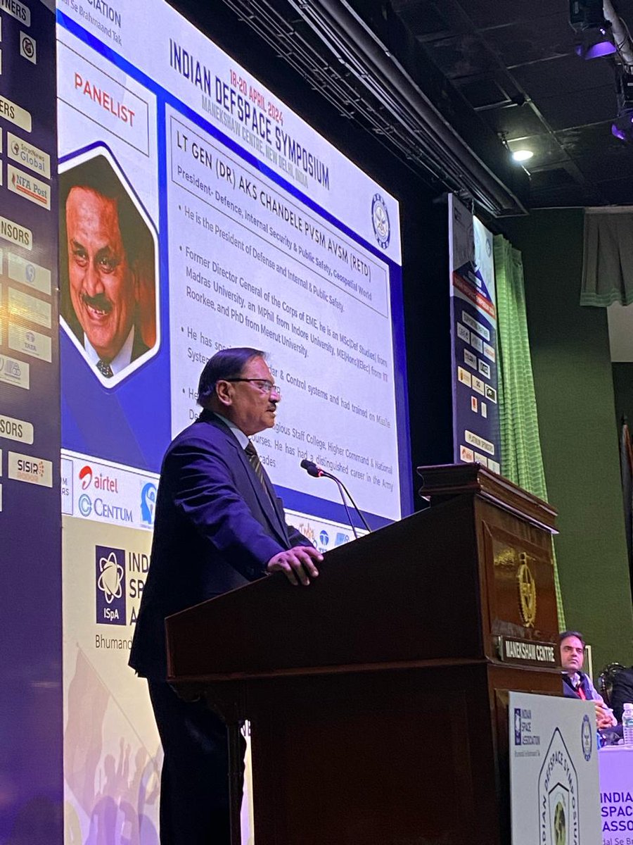
Lt. Gen (Dr.) AKS Chandele PVSM AVSM (Retd.), President of Defense, Internal Security & Public Safety at Geospatial World, emphasizes the critical role of geospatial technologies in space exploration and security. #GeospatialTech #SpaceSecurity

Genesys International integrates DIGIPIN into its 2D and 3D mapping platforms, advancing India’s geospatial infrastructure with standardized digital addressing. To know more: shorturl.at/Si22D #GenesysInternational #DIGIPIN #GeospatialTech #DigitalIndia #SmartMapping


🌍 Just wrapped up @geobuiz in Denver! 3 epic days of geospatial innovation with global experts discussing cutting-edge tech from space sensors to smart mobility. #GeospatialTech 📡

National Authority, CAMPA, MoEF&CC signs MoU with @BisagN_Official to integrate #GeospatialTech & #DigitalTools for monitoring & evaluation of afforestation efforts This marks a major step in using #Al, #GIS, & #RemoteSensing for restoring India's ecosystems. #MoEFCC…


We’re at #GWF2025 in Madrid this week — and tomorrow’s your last chance to catch us! Come see how GMV is driving the future of #GeospatialTech with Earth Observation, AI-powered analytics, and smart digital ecosystems 🌍


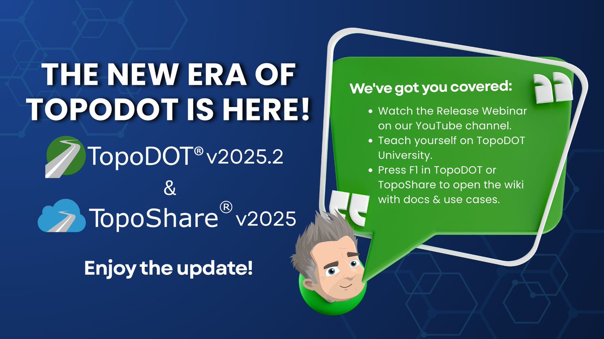
It’s TopoDOT Tuesday! 🚀 TopoDOT v2025.2 & TopoShare v2025 drop this week! What’s your favorite feature? How has the upgrade improved your workflow? Comment below or email [email protected]. Join our webinar tomorrow! #TopoDOTTuesday #TopoShare #GeospatialTech

Great to be back at #INTERGEO2024. Join us in reliving some of the best moments from the first day of the event! #INTERGEO #GeospatialTech #Innovation


🌍💡 Domain for sale: LogicSpatial.com! Ideal for geospatial tech, AI mapping, or data analytics platforms. A powerful and innovative name for your next big venture. Secure it today! 🚀🔗 #DomainForSale #LogicSpatial #GeospatialTech #DataAnalytics #MappingSolutions

The New Era of TopoDOT is Here! 💚 TopoDOT v2025.2 & TopoShare v2025 are out! 🔹 Watch our Release Webinar on YouTube 🔹 Check out the TopoDOT Users Conference Curriculum on the University 🔹 Press F1 for the wiki Enjoy the update! #TopoDOT #TopoShare #GeospatialTech #TechRelease

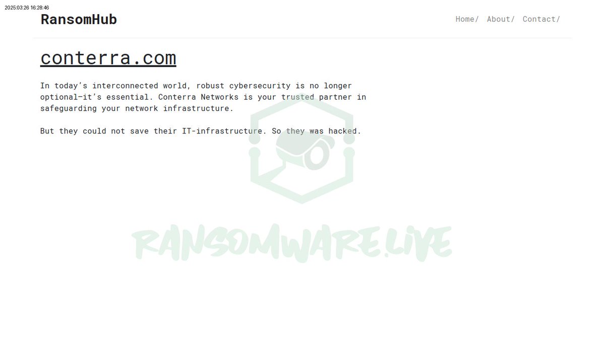
🚨 Conterra.com, a German geospatial data management firm, has fallen victim to a ransomware attack by ransomhub. Impacts may affect transport and public safety sectors. #Germany #Ransomware #GeospatialTech link: ift.tt/l2J5XzN

Think this is a photo of @lacoliseum? 👀 Spoiler: It's not! It was produced from spatial data acquired by a drone — and can be analyzed in 3D with #geospatial technologies. #Drone #GeospatialTech #SpatialData @USCDornsife @USC


Experience unparalleled accuracy with CORS networks! 🌍 Boost efficiency in surveying, agriculture, & infrastructure while driving innovation across industries. #GeospatialTech #PrecisionPositioning. noonuatoll.gov.mv/progress/226


#GeospatialTech and #GIS were crucial in tracking the #COVID19 pandemic, with Johns Hopkins Medical Centre's dashboard as a key resource for #global stakeholders: @Shravishtha_ajaykumar or-f.org/35082

#GeospatialTech and #GIS were crucial in tracking the #COVID19 pandemic, with Johns Hopkins Medical Centre's dashboard as a key resource for #global stakeholders: @Shravishtha_ajaykumar or-f.org/35082

2/2 📉 Profitability under pressure despite revenue growth — hit by higher costs & weaker margins. Focus now on scaling enterprise & mobility platforms to regain margin traction. #EarningsUpdate #IndiaInvesting #GeospatialTech

#GeospatialTech and #GIS were crucial in tracking the #COVID19 pandemic, with Johns Hopkins Medical Centre's dashboard as a key resource for #global stakeholders: @Shravishtha_ajaykumar or-f.org/35082

2/ If supply chains break down, it could stall the move away from fossil fuels and hurt the economy. So how do we find new sources? Enter Remote Sensing & GIS technologies. #GeospatialTech
Congrats to Alexander Arnold (M.S. Integrated Geospatial Tech, advised by Dr. Jae Sung Kim) for presenting “An Application of Neural Radiance Fields for Visualizing Mars Perseverance Rover Data” at #ASPRS2025! 🌍 🔗 community.asprs.org/2025symposium/… #GeospatialTech #MTUresearch
#GeospatialTech and #GIS were crucial in tracking the #COVID19 pandemic, with Johns Hopkins Medical Centre's dashboard as a key resource for #global stakeholders: @Shravishtha_ajaykumar or-f.org/35082

GIS powers disaster response, urban planning, climate modeling, precision farming, and even Pokémon GO! It’s spatial intelligence in action. 💡 #GeospatialTech #GIS #OpenSource #SpatialAnalysis
Next week: Discuss the '25 SoCal #wildfires with Gregory Elwood (@vcfd GIS). 📅 10/23 | 12:30–2 PM (PDT) 📍 AHF B57J & Zoom Learn how #geospatialtech supported emergency responders — and aids future #disasterplanning. calendar.usc.edu/event/ssi-brow…


இந்திய வானிலை ஆய்வு மையத்தால் உருவாக்கப்பட்டுள்ள புவியியல் தகவல் நடைமுறை அடிப்படையிலான புதிய தொழில்நுட்பம், சுயசார்புக்கு ஊக்கமளிக்கும் என்று, மத்திய அறிவியல் தொழில்நுட்பத்துறை இணையமைச்சர் டாக்டர் ஜிதேந்திர சிங் கூறியுள்ளார். #IMD #GeospatialTech #SelfReliantIndia


International Conference on Geospatial Innovations for Sustainable Landscapes concludes at IUST, hosted by Dept. of Land & Geomatics Engg. with ISPRS. Experts discuss climate, resource management & resilient planning. Awards given for top research. #GeospatialTech…
Minister Javid Ahmad Dar inaugurates 2-day International Conference on Sustainable Landscapes at IUST, Awantipora, in collaboration with ISPRS. Global experts and policymakers discuss geospatial tech for sustainable development. #IUST #GeospatialTech #SustainableDevelopment
Minister Javid Ahmad Dar inaugurates International Conference on Sustainable Landscapes at IUST, Awantipora, organized with ISPRS. The 2-day event unites global experts to explore geospatial tech for sustainable development. #IUST #GeospatialTech #SustainableLandscapes


Maps have evolved, and so has innovation🗺️📍 #GeospatialTech #InnovationInGoa #BuildInGoa #EmpoweredInGoa
Congrats to Alexander Arnold (M.S. Integrated Geospatial Tech, advised by Dr. Jae Sung Kim) for presenting “An Application of Neural Radiance Fields for Visualizing Mars Perseverance Rover Data” at #ASPRS2025! 🌍 🔗 community.asprs.org/2025symposium/… #GeospatialTech #MTUresearch

Last Wednesday, we kicked off @foss4g with a pre-conference gathering at @PRNHackerspace!🎉 It was amazing to see our supporters, geo-enthusiasts, and ambassadors of FOSS4G gather and share their passion for #geospatialtech.🌐 Excited for the conference!🤗 #Prizren2023


🌎🛰️ Ready to explore the world from a new perspective? Indian Institute of Remote Sensing, #ISRO, is now accepting applications for Geospatial Technology and Applications training programs! Interested candidates may apply by March 31st! 🚀 @isro #GeospatialTech #ExploreTheWorld
Our experience with various stakeholders highlights an important observation: #Africa needs #GeospatialTech #Data #Innovations rooted in local realities, guided by on-the-ground data, created to transform. Ready to co-create useful innovation? Contact us: africangeospace.com/contact

Foursquare Studio often releases new updates. See a few recent updates to our platform: 1️⃣ Directly upload/download PMTiles files 2️⃣ JSON Editor in Export Image Modal 🌟 Learn more: location.foursquare.com/studio/docs/re… #FoursquareStudio #geospatialtech #datavisualization


Congratulations to Prof. Siddhartha Khare from IIT Roorkee’s Civil Engineering Dept. on receiving the National Geospatial Emerging Faculty Fellow Award & National Geospatial Startup Award for his startup Bhoomicam! #IITRoorkee #GeospatialTech #NationalAwards, @EduMinOfIndia

Lt. Gen (Dr.) AKS Chandele PVSM AVSM (Retd.), President of Defense, Internal Security & Public Safety at Geospatial World, emphasizes the critical role of geospatial technologies in space exploration and security. #GeospatialTech #SpaceSecurity
Great to be back at #INTERGEO2024. Join us in reliving some of the best moments from the first day of the event! #INTERGEO #GeospatialTech #Innovation
Secure your spot for our Next Gen Geospatial Webinar. Distinguished Engineer Ib Green + Sr. Software Engineer Aditya Bhumbla are the experts bringing you insights you won't want to miss. 📅 Feb 13th, 2024 Register today: location.foursquare.com/resources/even… #geospatialtech #FSQstudio

National Authority, CAMPA, MoEF&CC signs MoU with @BisagN_Official to integrate #GeospatialTech & #DigitalTools for monitoring & evaluation of afforestation efforts This marks a major step in using #Al, #GIS, & #RemoteSensing for restoring India's ecosystems. #MoEFCC…

Through the Life of Litter project, students are using LoneStar GPS tech to trace litter through Louisiana’s waterways. Trackers update locations every 5 minutes. A public map shows the journey. 🛰️ Follow the tracker map: ow.ly/CmYy50VFKo8 #GIS #GeospatialTech #GPS

🌍✨ Join us this Wednesday for our monthly OpenStreetMap meetup! 🚀🗺️ Let’s collaborate, discuss, and learn together. Don’t miss out on the fun and networking! See you there! 👥🗓️ #OSM #Meetup #GeospatialTech #Community


At @SLU_Official's #GeoRes23 conference, Executive Director @EmilyLLB discusses how #geospatialtech can maximize #sustainability efforts: "The more precise we can be about which climate interventions we focus on—and when and where we focus them—the more effective we are."

🌍💡 Domain for sale: LogicSpatial.com! Ideal for geospatial tech, AI mapping, or data analytics platforms. A powerful and innovative name for your next big venture. Secure it today! 🚀🔗 #DomainForSale #LogicSpatial #GeospatialTech #DataAnalytics #MappingSolutions

#Infographic: This is how an airborne and mobile LIDAR works! #LiDAR #GeospatialTech #RemoteSensing #AirborneLiDAR #MobileLiDAR #3DMapping #SurveyingTech #MappingSolutions cc: @antgrasso @FrRonconi @ramonvidall


🔍 Is your geospatial analysis truly cloud-native? We break down what makes our platform unique and how we leverage a 100% cloud-native approach for scalable and secure analytics. hubs.ly/Q02LjXkz0 #GeospatialTech #CloudComputing

We’re at #GWF2025 in Madrid this week — and tomorrow’s your last chance to catch us! Come see how GMV is driving the future of #GeospatialTech with Earth Observation, AI-powered analytics, and smart digital ecosystems 🌍
Day 2 of the NAKSHA Master Trainer Training! The MPSeDC team conducted a hands-on session on Web GIS, empowering trainers with real-time mapping & spatial data integration skills. #NAKSHA 🌍 #GIS 🗺️ #GeospatialTech 📡 #DoLR #EoDB #WorldBank #EaseOfDoingBusiness #LandReforms…


Harnessing satellite technology 🛰️ to monitor Earth’s shifting landscapes! From landslides to subsidence, our imaging helps detect risks early, protecting communities & infrastructure. 🌍🔬 🔗 Learn more: infinityspace.org.uk #GeospatialTech #EarthObservation


Something went wrong.
Something went wrong.
United States Trends
- 1. Cal Raleigh 2,861 posts
- 2. Aaron Judge 12.5K posts
- 3. #911onABC 3,124 posts
- 4. AL MVP 7,876 posts
- 5. Shohei Ohtani 30.4K posts
- 6. ALL RISE 9,836 posts
- 7. RIP Beef N/A
- 8. Under Armour 9,217 posts
- 9. #internetinvitational N/A
- 10. Purdue 5,379 posts
- 11. #RepBX N/A
- 12. Megyn Kelly 45.5K posts
- 13. Big Dumper N/A
- 14. Nike 28.2K posts
- 15. Blue Origin 12.8K posts
- 16. #TNFonPrime 1,540 posts
- 17. #LatinGRAMMY 39.8K posts
- 18. Senator Fetterman 24.9K posts
- 19. Aden Holloway N/A
- 20. Curry Brand 7,667 posts