#osmdata search results

Under the mapping of new cities initiative, over 500k buildings and 200km of roads have been added to the OSM platform, this information is freely and openly available for organizations and local governments to incorporate in their future planning activities. #osmdata #OpenSource


OpenStreetMap (OSM) is an open world geographic database updated and maintained by a community of volunteers. We can use the #osmdata package in #R to retrieve OSM data including roads, shops, railway stations, and much more. The #available_features() function can be used to…


Sure how else would you spend a rainy Bank Holiday Monday other than rendering fortified Dutch villages in #rstats? Fort Bourtange, Netherlands. LiDAR: Actueel Hoogtebestand Nederland. Overlays: @openstreetmap via the #osmdata pkg. Rayshading witchcraft: #rayshader.


Les microbibliothèques sont visibles dans le rendu à défaut d'OpenStreetMap. Voici un exemple sur Avignon openstreetmap.org/?mlat=43.94451… Ils sont également visibles sur #OSMdata ici demo.openstreetmap.fr//map?layers=co… @OSMdata


📍🌍📍🌍📍🗺️📍🌍📍 Just maintaining the standard as usual, UCCyouthmappers engage it's members again yesterday☺️ where members got to know how to download OSM data and perform buffer analysis😌🗺️ #BufferAnalysis #OSMdata we don't just build maps, we build mappers😌🌍


If you are a fan of #OSMData, you can now access a new set of feature services for @ArcGISOnline ow.ly/FLbt50zhDQn

Just announced! @Esri and @Facebook are working together to assist @openstreetmap mappers with enhanced #OSMdata. Learn more: ow.ly/8qDO50AxQhU #EsriUC #OpenStreetMap #RapID #JOSM

The Circuit de Barcelona-Catalunya - venue for today's @F1 #SpanishGP 🇪🇸🏎️🏁@Circuitcat_eng LiDAR from @IGNSpain. Overlays from @openstreetmap via #osmdata pkg. Rendered in #rstats with #rayshader.

Vous aimez pédaler ou la foulée pour brûler vos calories ?Voici de nouveaux affichages valorisant les itinéraires vélos 🚲 demo.openstreetmap.fr//map?layers=co… ou randos 🥾 demo.openstreetmap.fr//map?layers=co… . Leur bénéfice est d'identifier les boucles manquantes pour les rajouter ou les créer. #OSMdata


easy #humangeography data exploration in #rstats using #osmdata and #leaflet packages to see restaurants by cuisine in Tripoli

Suite à l'annonce #COVID19 sur les centres commerciaux : une URL des pôles incluant shop=mall . demo.openstreetmap.fr//map?layers=co… Il serait intéressant de rajouter pour les opérateurs de CCommerciaux le tag operator=* (Klépierre,...) toute-la-franchise.com/vie-de-la-fran… #OpenStreetMap #OSMdata @OSMdata


Shell Petroleumhaven, Pernis, Rotterdam, The Netherlands LiDAR from ahn.nl (0.5m but downsampled to 2m here) with @openstreetmap overlays via #osmdata, rendered in #rayshader #rstats

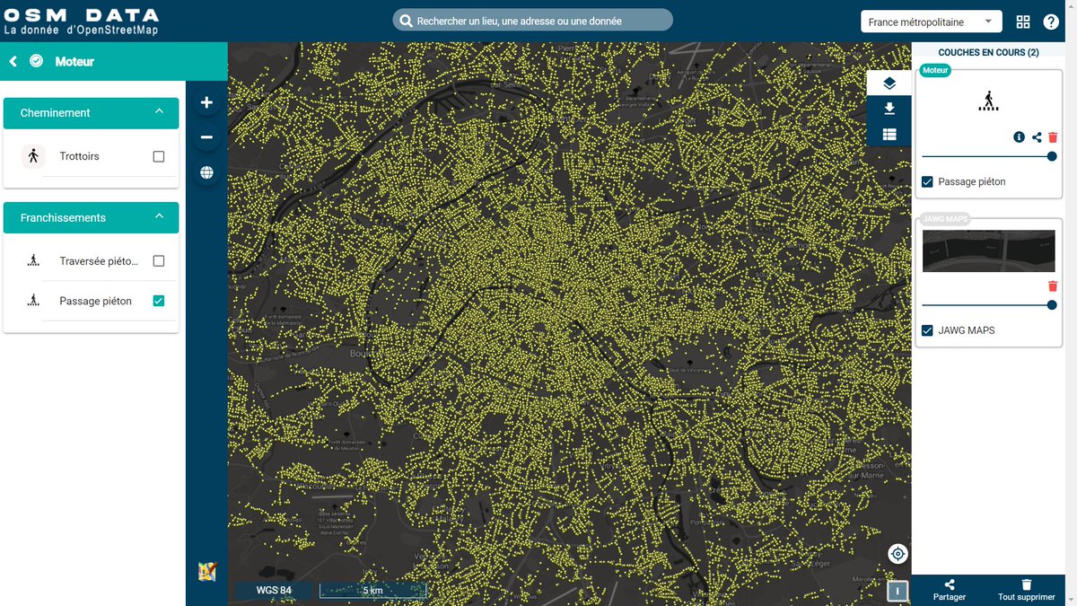
Les passages piétons qualifiés en France visibles grâce à #OSMdata !!! @MurielLarrouy @CeremaCom #acessibilitéhandicapés #OpenStreetMap cc @armeltayou @JLZIMMERMANN @cartocite @ljbouere @CartoCharles @Acceslibre_Gouv

Jules Verne, né le 8 février 1828 à Nantes, mort en mars 1905 à Amiens, est l'écrivain français dont l'œuvre est, constituée de romans d'aventures évoquant les progrès scientifiques du XIXᵉ siècle. Découvrez ses rues en France dans OpenStreetMap! demo.openstreetmap.fr//map?layers=co… #OSMdata


#30daymapchallenge Day 8: OpenStreetMap Clinicas de Corrientes-Argentina, hecho con #RStats y paquete #Osmdata #QGIS #maps

Si vous pensez avoir fait le tour des contributions sur votre territoire, voici une petite nouveauté : la qualification du bâti dans OpenStreetMap. Est-il qualifié en tant que maison ... ? #OSMdata #OSMquality

The town of Sarnen, Switzerland Trying something slightly different with the overlays on this one, so I can include some height shading 0.5m DEM © swisstopo @swisstopo (downsampled to 2m), @openstreetmap via #osmdata, rendered in #rayshader #rstats

Through DroneDeploy's social impact program, DroneDeploy.org is collaborating with OSM Uganda to process, visualize and analyze drone aerial imagery to integrate the use of drone technology in disaster response. #mappingforimpact #OSMdata #dronedeploy


🗺️ Red vial de #Cartagena en R Este ejercicio combina varias librerías en R (#osmdata, #sf, #ggspatial y #ggplot2) para construir un mapa de la red vial, con base en datos de #OpenStreetMap 🧭 Ideal para análisis urbanos y planificación territorial. #DataViz #AnálisisEspacial


📍🌍📍🌍📍🗺️📍🌍📍 Just maintaining the standard as usual, UCCyouthmappers engage it's members again yesterday☺️ where members got to know how to download OSM data and perform buffer analysis😌🗺️ #BufferAnalysis #OSMdata we don't just build maps, we build mappers😌🌍
📍🌍❗️🌍❗️🗺️❗️🌍❗️🌍📍 You called for it and we delivered😊 Aspiring mappers were taught how to use the quality data we upload to OSM and how it can be utilized efficiently for spatial analysis🗾 #SpatialAnalysis🗺️ #OSMdata #UCCyouthmappers #WeDon’tJustBuildMapsWeBuildMappers


📍🌍📍🗺️📍🌍📍🗺️📍🌍 Youthmappers is not only about mapping but the use of quality data we upload to OSM😊 It focuses on: Using OSM Data in ArcMap. It showcase how OSM contributions can be utilized for spatial analysis in ArcGIS software. #WeDon’tJustBuildMaps #AnalysisAndMaps🗾

OpenStreetMap (OSM) is an open world geographic database updated and maintained by a community of volunteers. We can use the #osmdata package in #R to retrieve OSM data including roads, shops, railway stations, and much more. The #available_features() function can be used to…

Trying to make the sea blue in this map is doing my head in. I'm not used to feeling this much rage in R - it's like being a student again 🙃 #rstats #rmaps #osmdata


Working together with @openstreetmap data group we can make #osmdata better. #StateoftheMap #SotM #SotM2024


L'outil démonstrateur et moissonneur de la donnée OSM prépare sa mue. #OSMdata Merci @armeltayou pour cette nouvelle série de surprises ✨


Check out my new blog post on creating a map of the rivers in Taiwan in ggplots using OpenStreetMap data: genchanghsu.github.io/ggGallery/post… #RStats #ggplot2 #osmdata

#30daymapchallenge Day 8: OpenStreetMap Clinicas de Corrientes-Argentina, hecho con #RStats y paquete #Osmdata #QGIS #maps

Just announced! @Esri and @Facebook are working together to assist @openstreetmap mappers with enhanced #OSMdata. Learn more: ow.ly/8qDO50AxQhU #EsriUC #OpenStreetMap #RapID #JOSM
If you are a fan of #OSMData, you can now access a new set of feature services for @ArcGISOnline ow.ly/FLbt50zhDQn
OpenStreetMap (OSM) is an open world geographic database updated and maintained by a community of volunteers. We can use the #osmdata package in #R to retrieve OSM data including roads, shops, railway stations, and much more. The #available_features() function can be used to…
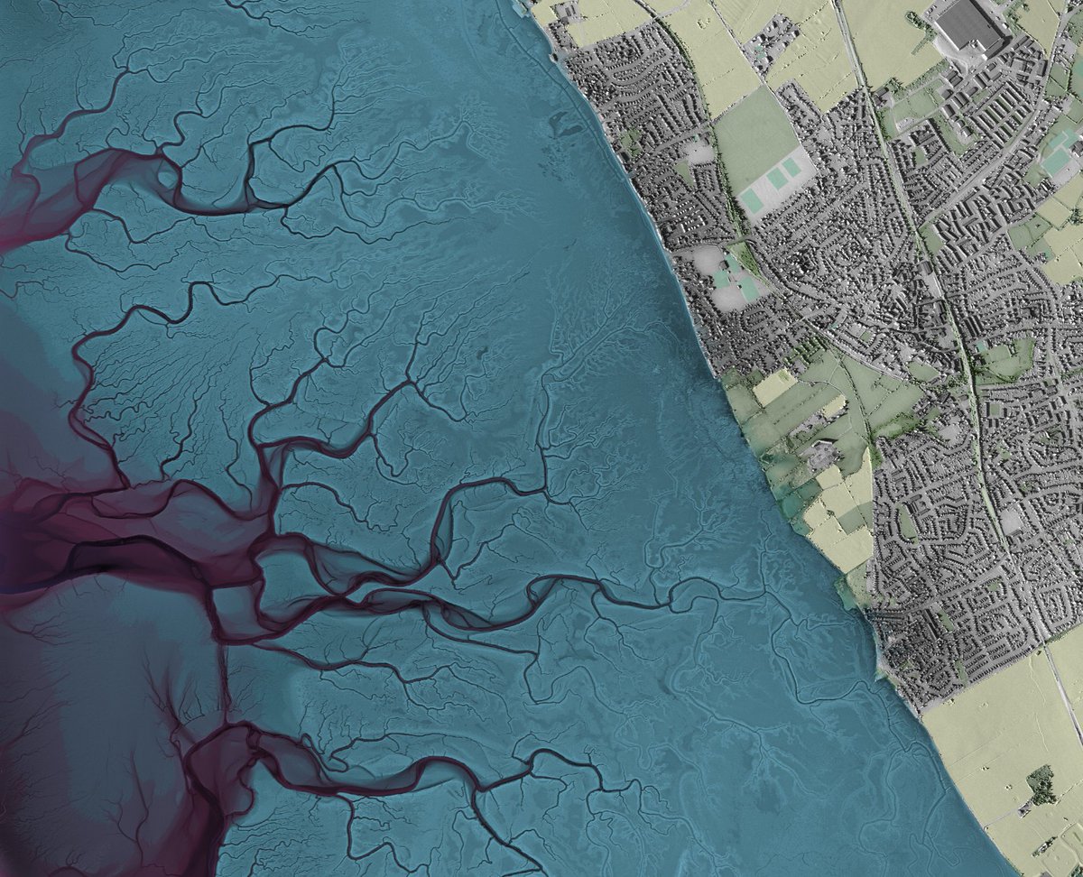
Eastbourne Pier, East Sussex, UK. I like how the ridges of sand at the high tide line are picked up by this very detailed LiDAR data 25cm LiDAR from @DefraGovUK, @openstreetmap @osmuk overlays via #osmdata, rendered in #rayshader #rstats

Shell Petroleumhaven, Pernis, Rotterdam, The Netherlands LiDAR from ahn.nl (0.5m but downsampled to 2m here) with @openstreetmap overlays via #osmdata, rendered in #rayshader #rstats
The town of Sarnen, Switzerland Trying something slightly different with the overlays on this one, so I can include some height shading 0.5m DEM © swisstopo @swisstopo (downsampled to 2m), @openstreetmap via #osmdata, rendered in #rayshader #rstats


Les passages piétons qualifiés en France visibles grâce à #OSMdata !!! @MurielLarrouy @CeremaCom #acessibilitéhandicapés #OpenStreetMap cc @armeltayou @JLZIMMERMANN @cartocite @ljbouere @CartoCharles @Acceslibre_Gouv
The containership port in Southampton, UK @DPWorldUK. An interesting location as it experiences a double high water. 50cm LiDAR from @DefraGovUK via #EAlidaR, @openstreetmap @osmuk overlays via #osmdata, rendered in #rayshader #rstats


Neston, The Wirral, UK Finally took the time to configure #EAlidaR by @hughagraham and I'm glad I did - so easy to pull in UK LiDAR data now. A bit of artistic license on the palette (thanks also to Hugh for this) @DefraGovUK #osmdata #rayshader #rstats
Under the mapping of new cities initiative, over 500k buildings and 200km of roads have been added to the OSM platform, this information is freely and openly available for organizations and local governments to incorporate in their future planning activities. #osmdata #OpenSource
Suite à l'annonce #COVID19 sur les centres commerciaux : une URL des pôles incluant shop=mall . demo.openstreetmap.fr//map?layers=co… Il serait intéressant de rajouter pour les opérateurs de CCommerciaux le tag operator=* (Klépierre,...) toute-la-franchise.com/vie-de-la-fran… #OpenStreetMap #OSMdata @OSMdata
📍🌍📍🌍📍🗺️📍🌍📍 Just maintaining the standard as usual, UCCyouthmappers engage it's members again yesterday☺️ where members got to know how to download OSM data and perform buffer analysis😌🗺️ #BufferAnalysis #OSMdata we don't just build maps, we build mappers😌🌍
@mapuganda invites the local OSM community to participate in the mapping and validation of Uganda's new cities. The current tasks include Gulu, Soroti and Mbale, let's complete these tasks together. @youthmappers #mapping #maps #OSMdata #mapuganda #Map


Les microbibliothèques sont visibles dans le rendu à défaut d'OpenStreetMap. Voici un exemple sur Avignon openstreetmap.org/?mlat=43.94451… Ils sont également visibles sur #OSMdata ici demo.openstreetmap.fr//map?layers=co… @OSMdata
Sure how else would you spend a rainy Bank Holiday Monday other than rendering fortified Dutch villages in #rstats? Fort Bourtange, Netherlands. LiDAR: Actueel Hoogtebestand Nederland. Overlays: @openstreetmap via the #osmdata pkg. Rayshading witchcraft: #rayshader.
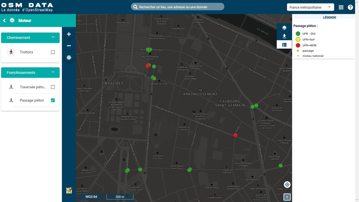
Et là un peu plus détaillé (toujours à Orange) : les traversée piétonnes non plus en ponctuel mais en linéaire avec les trottoirs. Il reste encore du travail pour qualifier la praticabilité de ces traversées en fauteuil roulant. #OSMdata

Through DroneDeploy's social impact program, DroneDeploy.org is collaborating with OSM Uganda to process, visualize and analyze drone aerial imagery to integrate the use of drone technology in disaster response. #mappingforimpact #OSMdata #dronedeploy

[use case] Wall Art with osmdata and ggplot2, by @deanmarchiori discuss.ropensci.org/t/osmdata-use-… osmdata 📦 by @bikesRdata #rstats #osmdata
![rOpenSci's tweet image. [use case] Wall Art with osmdata and ggplot2, by @deanmarchiori
discuss.ropensci.org/t/osmdata-use-…
osmdata 📦 by @bikesRdata
#rstats #osmdata](https://pbs.twimg.com/media/EQeABY2UUAAnKNE.jpg)
![rOpenSci's tweet image. [use case] Wall Art with osmdata and ggplot2, by @deanmarchiori
discuss.ropensci.org/t/osmdata-use-…
osmdata 📦 by @bikesRdata
#rstats #osmdata](https://pbs.twimg.com/media/EQeABY4UUAA2JnM.jpg)
Something went wrong.
Something went wrong.
United States Trends
- 1. Northern Lights 45.3K posts
- 2. #Aurora 9,541 posts
- 3. #DWTS 53.1K posts
- 4. Carmilla 2,110 posts
- 5. MIND-BLOWING 36.6K posts
- 6. #RHOSLC 7,197 posts
- 7. AI-driven Web3 N/A
- 8. H-1B 35.2K posts
- 9. Justin Edwards 2,477 posts
- 10. #GoAvsGo 1,566 posts
- 11. Sabonis 6,238 posts
- 12. #MakeOffer 9,259 posts
- 13. Louisville 18.1K posts
- 14. Creighton 2,325 posts
- 15. Eubanks N/A
- 16. Andy 60.3K posts
- 17. Gonzaga 3,006 posts
- 18. Cleto 2,585 posts
- 19. Zach Lavine 2,659 posts
- 20. H1-B 4,116 posts