#spatialdata search results

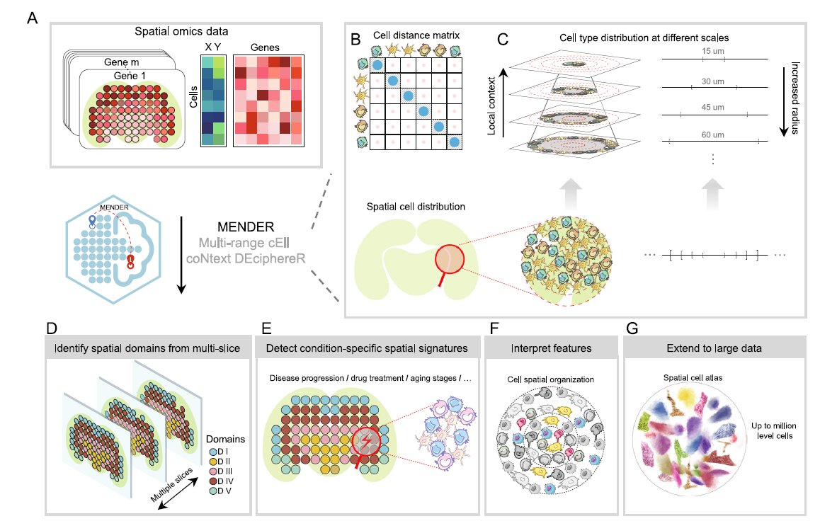
We love learning about new #ComputationalTools for analyzing #SpatialData! MENDER is a novel tissue structure identification tool utilizing cellular neighborhood structures observed across spatial technologies now published in @NatureComms. Learn more: hubs.ly/Q02fCYP20


Awesome week last week representing both @napari_imaging and #SpatialData @scverse at @EuroSciPy2024. It was great to meet maintainers and contributors to the libraries we use. Also grateful for the opportunity to have a flashlight talk on #numpydantic and a little bit on #LinkML


2 WEEKS AWAY! 🥳 Prevent yourself from future FOMO & sign up for Esri's popular course today: esri.social/xJq350SWk38 #SpatialDataScience #ArcGIS #SpatialData

URHIAsti on stage today 11.00 🇪🇪@utuscience @UniTurku #spatialdata #foss4ge @foss4ge @HuDi_Project @BEDLAN_Uralic


Today presenting current status at the #foss4ge2024 Tartu “URHIA's Open Data Journey in Spatial Exploration” 📅Fri, 5.7.2024 at 11.00 📍Omicum building Live stream link available foss4ge.television.ee

🌐 Introducing PA statistical methods: Geographic Information Systems (GIS). This integrates spatial data, ideal for exploring environmental influences on physical activity. GIS requires extensive data handling skills. #SpatialData #PhysicalActivityResearch


📍 Looking to expand your business to new locations, but worried about the impact on existing sales? You need Cannibalization Analysis! Maximize profits and safeguard existing revenue with this step-by-step tutorial 👉 hubs.ly/Q02wMFYv0 #analytics #spatialdata

Happy to share earlier this month, Avipsa Roy, Asst Prof in Urban Planning & Public Policy was invited as a guest lecturer to discuss Spatial Data Science's influence on policy making at IIT Kharagpur, Visva Bharati University, ISI Kolkata, and IISc Bengaluru. #spatialdata #up3


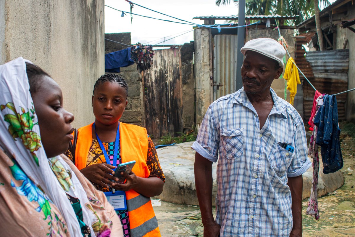
Big up to Wajumbe👏🥳 for aiding mappers on the ground with their invaluable local knowledge & resident trust. They play a crucial role in gathering accurate #spatialdata for the baseline survey & pinpointing initial information, i.e., WCP's locations, dumping sites & waste piles
📍 Looking to expand your business to new locations, but worried about the impact on existing sites? You need Cannibalization Analysis! Maximize profits and safeguard existing revenue with this step-by-step tutorial 👉 hubs.ly/Q02DqVqK0 #analytics #spatialdata

Applied #SpatialData! #BigData #Analytics #DataScience #AI #MachineLearning #IoT #IIoT #GeoSpatial #Python #RStats #TensorFlow #Java #JavaScript #ReactJS #GoLang #CloudComputing #Serverless #DataScientist #Linux #Programming #Coding #100DaysofCode geni.us/Applied-Spatia…


making spatial data easy for pros and non-gis users, catch the full video exclusively on collide.io #gis #spatialdata #dataplatform

Welcome to the 6th day of 12 Days of NanoString! Interested in leaping to single-cell spatial in these applications? nanostring.com/events/spatial… #SpatialData #CellSegmentation #SpatialTranscriptomics #SingleCellImaging


Ready to tackle climate risk? 🌍 See how CARTO helps insurers analyze threats like hurricanes & fires with seamless spatial insights. 📩 Request your demo now: hubs.ly/Q02_3zlc0 #ClimateRisk #SpatialData #CARTO #DataAnalytics

A well-designed and comprehensive summary graph about geospatial data tools a couple of times already, circulating on socials by CARTO and their article titled 'What is Spatial Data Science?' lnkd.in/d458sxG6 #datascience #spatialdata #spatialdatascience #gis #python


What is @ApacheSedona and what are its common use cases? Discover how this clustering computing system, designed for processing large-scale spatial data, treats spatial data as a first-class citizen. bit.ly/3ZRL24U #ApacheSeonda #SpatialData


What map have you found geoaweseome recently? Spilhaus Ocean Currents map shows how ocean water moves around the world. We love this project! Check it by yourself: arcgis.com/apps/mapviewer… #Geospatial #Geoawesome #SpatialData #cartography #maps #map

📍 Geospatial data relates information to specific locations, revealing patterns and insights that help us plan, protect, and improve our world. 🌍 #SpatialData #GeoInsights


At JapakGIS, we assist Public health agencies use Web Maps dashboards to track epidemic spread, visualize hotspots, and allocate medical resources effectively. #JapakGIS #SpatialData #SpatialAnalytics #GISForDevelopment #GeospatialSolutions


the data tells truly reflects the real world. #SpatialData #SpatialDependence #SpatialLag #SpatialErrorModel #SpatialAnalysis
neighborhoods with low service access. * Environmental scientists use it to identify pollution concentration zones. 💡 In short, LISA helps transform maps into insights one local pattern at a time. #SpatialData #LISA #SpatialAutocorrelation #DataScience #GeospatialAnalysis #GIS
💡 Why it matters: Hotspot analysis helps researchers, urban planners, and decision-makers pinpoint priority areas, allocate resources effectively, and design targeted interventions. #SpatialData #GIS #GeospatialAnalysis #DataScience #HotspotAnalysis
💡 Don’t miss it, it’s happening this evening at 6 PM (WAT)! #SDSSN #GeospatialDataScience #SpatialData #GIS #DataScience
💡 Don’t miss it, it’s happening tomorrow evening at 6 PM (WAT)! #SDSSN #GeospatialDataScience #SpatialData #GIS #DataScience

Proud to support the expansion of Land iQ with MetroMap aerial imagery. $20M investment → greater access, new tools, smarter land planning. nsw.gov.au/ministerial-re… #LandIQ #MetroMap #SpatialData


Nic Klopper, CEO of 1map Spatial Solutions, shared insights on using maps for effective valuations at the SAIV Legislative/ Statutory Valuations & MPRA Seminar in Johannesburg. #SpatialData #1MapCityManager #1Map #PropertyValuation #MPRA #SAIV


Understanding both helps researchers, urban planners, and data scientists make informed, location-based decisions. 💡 Stay tuned as we break down more key spatial analysis concepts! #SpatialData #GeospatialAnalysis #DataScience #SpatialAutocorrelation #GIS #SDSSN

#SpatialData drives critical systems from urban planning and logistics to disaster response and national security. It tells us not just where, but when, how, and why things happen, powering #Innovations. Learn more: weforum.org/stories/2025/0…


We love learning about new #ComputationalTools for analyzing #SpatialData! MENDER is a novel tissue structure identification tool utilizing cellular neighborhood structures observed across spatial technologies now published in @NatureComms. Learn more: hubs.ly/Q02fCYP20

More oblique views. Now I'll have to find out how to bring point data to Blender so I can overlay precise locations. I've managed to bring in shapefile but haven't been able to convert that into object. #gis #blender #spatialdata

Welcome to the 6th day of 12 Days of NanoString! Interested in leaping to single-cell spatial in these applications? nanostring.com/events/spatial… #SpatialData #CellSegmentation #SpatialTranscriptomics #SingleCellImaging

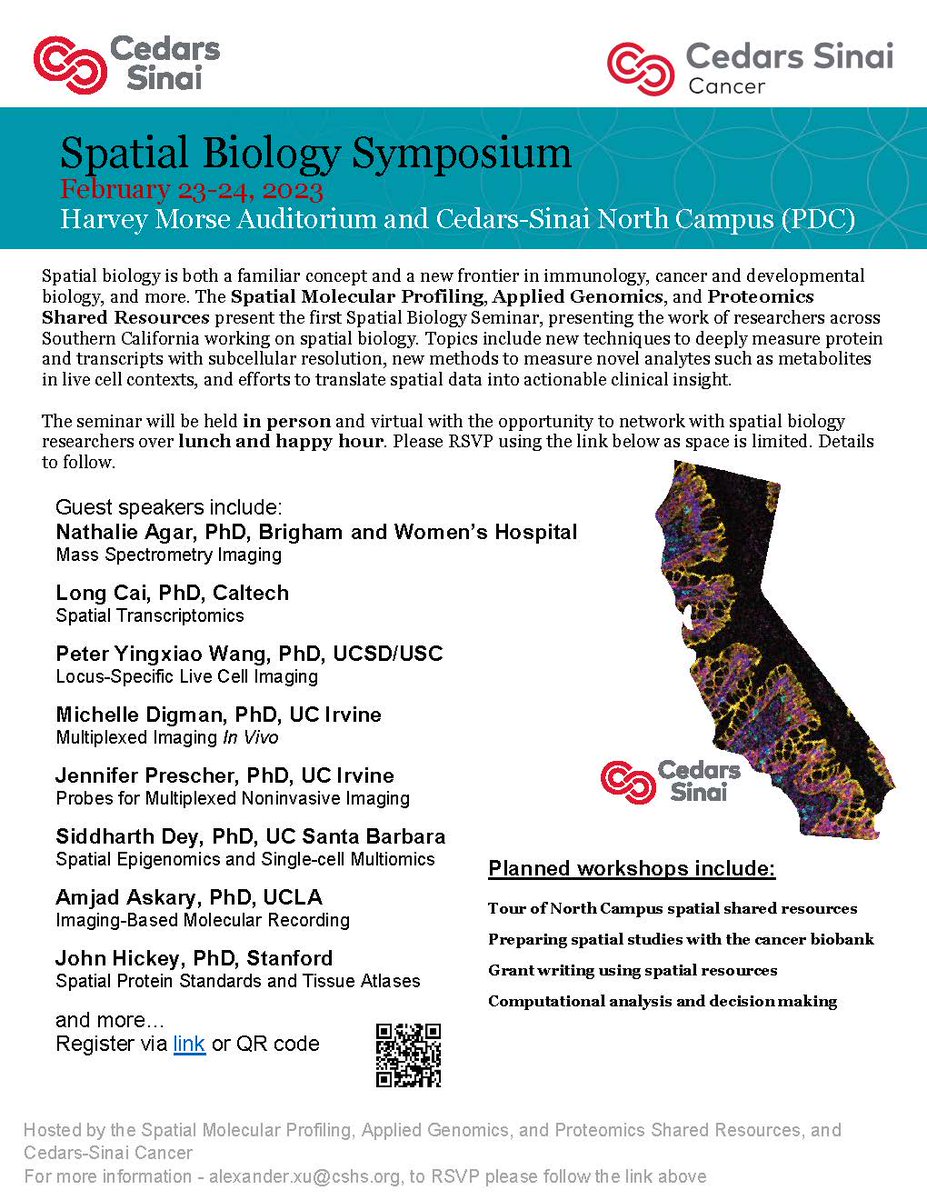
#CedarsSinaiCancer's first #SpatialBiology Symposium is taking place covering topics like new techniques to measure proteins, methods to measure novel analytes, and efforts to translate #spatialdata into clinical insights. Virtual attendees are welcome!
URHIAsti on stage today 11.00 🇪🇪@utuscience @UniTurku #spatialdata #foss4ge @foss4ge @HuDi_Project @BEDLAN_Uralic
Today presenting current status at the #foss4ge2024 Tartu “URHIA's Open Data Journey in Spatial Exploration” 📅Fri, 5.7.2024 at 11.00 📍Omicum building Live stream link available foss4ge.television.ee

#showcasing #students Jevaughn #spatialdata #analyst #Jamaica jevaughnhenry.wixsite.com/my-site/projec… #ePortfolio #PLUS #creative #drone #projects #Check his #CV & impressive #skills list 😎 #data #visualisation #UAV #Copernicus #DigitalEarth #EO #GI #Geocommunication #UPOL #Geospatial #MSc
My latest article, 𝐄𝐱𝐩𝐥𝐨𝐫𝐢𝐧𝐠 𝐋𝐚𝐫𝐠𝐞-𝐬𝐜𝐚𝐥𝐞 𝐑𝐚𝐬𝐭𝐞𝐫 𝐏𝐨𝐩𝐮𝐥𝐚𝐭𝐢𝐨𝐧 𝐃𝐚𝐭𝐚, is out on @TDataScience: towardsdatascience.com/exploring-larg… #geosptaialdata #geodata #spatialdata #datavisualization #datascience #data #datafam #visualization #gis #geography


Spatialnode Monday Tips It's a new week! Let's think spatially this week! #geospatial #mondaymotivation #spatialdata
🌐 Introducing PA statistical methods: Geographic Information Systems (GIS). This integrates spatial data, ideal for exploring environmental influences on physical activity. GIS requires extensive data handling skills. #SpatialData #PhysicalActivityResearch

A round of applause to all the contributors of the Map El Niño Mapathon Campaign 👏✨️👏. Each week is an advancement in the number of contributions being made. Well done everyone. And by the way we're live for this week's Mapathon 😀 #elninathon #spatialdata


My recent article, 𝐄𝐱𝐩𝐥𝐨𝐫𝐢𝐧𝐠 𝐋𝐚𝐫𝐠𝐞-𝐬𝐜𝐚𝐥𝐞 𝐑𝐚𝐬𝐭𝐞𝐫 𝐏𝐨𝐩𝐮𝐥𝐚𝐭𝐢𝐨𝐧 𝐃𝐚𝐭𝐚, published on @TDataScience: towardsdatascience.com/exploring-larg… @WorldPopProject #geosptaialdata #geodata #spatialdata #gis #geography #datascience #datavisualizatiom #ai


Applied #SpatialData! #BigData #Analytics #DataScience #AI #MachineLearning #IoT #IIoT #GeoSpatial #Python #RStats #TensorFlow #Java #JavaScript #ReactJS #GoLang #CloudComputing #Serverless #DataScientist #Linux #Programming #Coding #100DaysofCode geni.us/Applied-Spatia…

Dr. Urooj Saeed Senior Specialist GIS, presented GIS data sets, layers and analysis. The interactive session with CERP team included discussion on GIS & RS data, attributed data, spatial patterns & spatial data repository and big data repository. #DataAnalytics #spatialdata


🌐 Introducing PA statistical methods: Geographic Information Systems (GIS). This integrates spatial data, ideal for exploring environmental influences on physical activity. GIS requires extensive data handling skills. #SpatialData #PhysicalActivityResearch


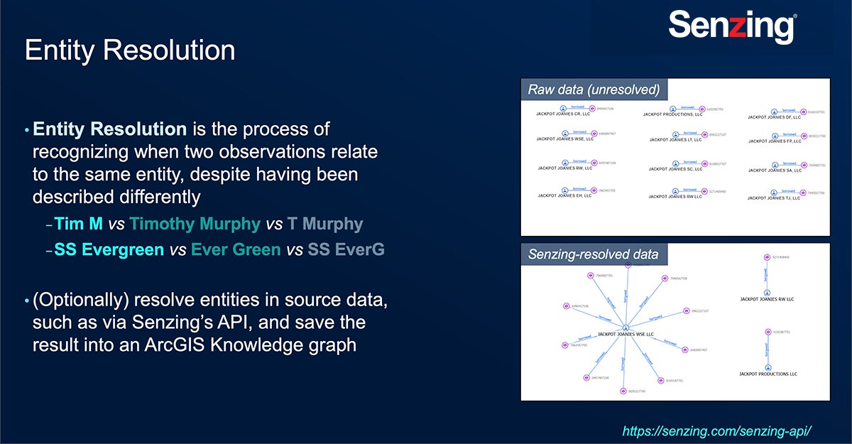
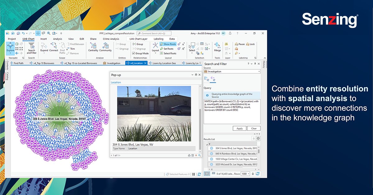
Last week my team and I attended #EsriFedGIS2023. @Senzing and @Esri have partnered to merge #NonSpatial third-party data together with #SpatialData using #ArcGIS Knowledge and perform link analysis using #ArcGISpro. #ArcGISKnowledge #SenzingPartner #ESRIPartner
Awesome week last week representing both @napari_imaging and #SpatialData @scverse at @EuroSciPy2024. It was great to meet maintainers and contributors to the libraries we use. Also grateful for the opportunity to have a flashlight talk on #numpydantic and a little bit on #LinkML

[Rappel]✨🗓️🗺️🎁✨Journée d'études de l'Action de recherche (Carto)graphies et (Géo)visualisation de données du @GdrMagis ➡ Rennes - 6 janvier 2023 🔗En savoir plus github.com/magisAR9/JEGeo… #spatialdata #covoiturage #flux #flowmap #cartostats #geoviz
![fbahoken's tweet image. [Rappel]✨🗓️🗺️🎁✨Journée d'études
de l'Action de recherche (Carto)graphies et (Géo)visualisation de données du @GdrMagis
➡ Rennes - 6 janvier 2023
🔗En savoir plus github.com/magisAR9/JEGeo…
#spatialdata #covoiturage #flux #flowmap #cartostats #geoviz](https://pbs.twimg.com/media/Flnz5bZWQAA7p8F.jpg)
Something went wrong.
Something went wrong.
United States Trends
- 1. Good Friday 43.6K posts
- 2. #FridayVibes 3,584 posts
- 3. Summer Walker 20.3K posts
- 4. #FinallyOverIt 6,544 posts
- 5. Happy Friyay 1,078 posts
- 6. Wale 35.4K posts
- 7. #FridayMotivation 2,205 posts
- 8. Go Girl 26.8K posts
- 9. #fridaymorning 1,156 posts
- 10. RED Friday 2,166 posts
- 11. #FursuitFriday 10.5K posts
- 12. Meek 6,173 posts
- 13. Robbed You 4,589 posts
- 14. Bubba 8,292 posts
- 15. Saylor 26.5K posts
- 16. Bihar 336K posts
- 17. 5sos 23.7K posts
- 18. 1-800 Heartbreak 1,738 posts
- 19. Justin Fields 10.4K posts
- 20. Arrest Bill Clinton 6,209 posts