
J.S. Held Forensic Meteorology – Weather Insights
@JS_Held_Weather
Weather risk updates and analysis from @JS_Held forensic meteorologists. To engage our experts, contact [email protected].
J.S. Held will share real time weather risk updates and analysis from our forensic meteorology team. These updates will be delivered both via video and images as time allows. Happy Meteorological Fall!
October 7, 2025 Weather Risk Update: Jerry is out there now...but...like many before it, will likely stay over water during the entire journey. Most likely a week from now, Jerry will still be over the water and starting to curl northeast.


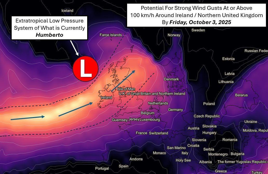
October 1, 2025 Wx Risk Update: #Bermuda in line for Hurricane Imelda tonight with a risk of 80+ MPH winds, though it looks like a narrow corridor of 100 MPH or so is possible just south of the island. Leftovers of Humberto should translate into gusty wind for Ireland/UK Friday.
9/30/25: As Humberto makes a hard right turn over the Atlantic and evolves into an extratropical low pressure system, Ireland and the UK have an increased risk of strong winds by Friday. The potential for strong gusts of 100 km/h (61 MPH) or higher in spots is there as the system…
There were hints of Imelda being pulled back out to sea as early as Saturday, however, latest consensus data has generally confirmed this trend. In short, Imelda poses a much lower risk to the U.S. than in prior updates as Humberto effectively pulls Imelda east.
9/26/25 Weather Risk Update: Still mainly watching Invest 94L to be named this weekend and track northwest toward the U.S. Things can still change, but here are the latest risks for the southeast U.S. into early next week.
Active times in the Atlantic right now and for those at interest, keep an eye particularly on Invest 94L. As of this update, it has no name yet, but may have sights on the United States. Still early in the game, but, worth raising a caution flag to keep an eye on it.
September 19, 2025: Weather Risk Update. The tropics have come alive again, however, there is no risk to the United States at this time. This video discusses Tropical Storm Gabrielle and the probable path Gabrielle will take into early next week.
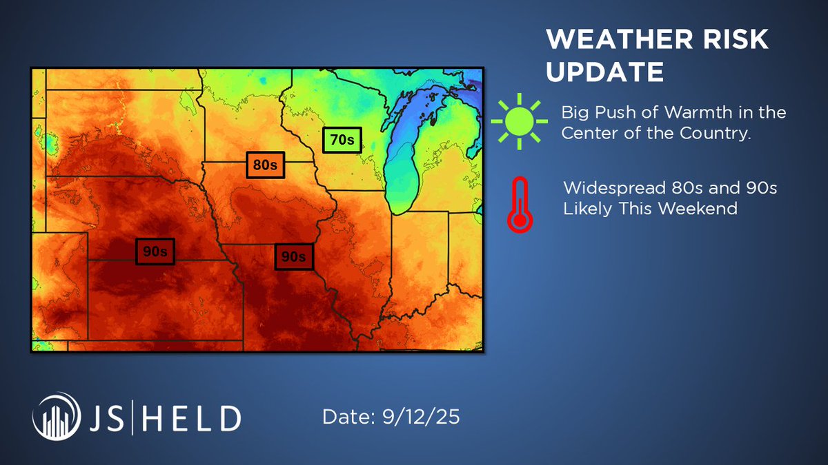
With the tropics remaining fairly quiet, much of the weather risk is confined to warmer temperatures (90+ degrees) in the center of the country. This may come with associated storm risks in parts of the Plains/Midwest into this weekend (9/13-9/14).

Hurricane Kiko is a major hurricane (Cat 4), though expected to weaken as it gets close to Hawaii early next week. Probabilities of tropical storm force winds remain forecast around 10-30% during the 9/7 to 9/8 time period. Heavy rain possible early-mid next week. (9/7-9/9).

Multiple tropical risks to update you on going into this weekend. T.S. Lorena is mainly a rain threat, but in desert/dry climates, this may cause areas of flash flooding. This tropical moisture may continue to move east into portions of south Texas by Sunday (9/7).


United States Trends
- 1. James Franklin 42.9K posts
- 2. Drake Maye 13.3K posts
- 3. George Pickens 7,114 posts
- 4. Cowboys 44.5K posts
- 5. Jets 103K posts
- 6. Penn State 58.7K posts
- 7. Rico Dowdle 3,543 posts
- 8. Justin Fields 21.8K posts
- 9. Steelers 48.4K posts
- 10. Colts 43.9K posts
- 11. Cooper Rush 2,747 posts
- 12. Zay Flowers 1,914 posts
- 13. Puka 7,927 posts
- 14. #Browns 2,861 posts
- 15. Eberflus 2,051 posts
- 16. #RavensFlock 2,276 posts
- 17. Diggs 6,050 posts
- 18. Rodgers 7,278 posts
- 19. Derrick Henry 2,799 posts
- 20. Broncos 45.1K posts
Something went wrong.
Something went wrong.