
JavaHurricane
@JavaHurricane
Postgraduate student in physics Genderfluid Tropical cyclone tracker and cricket follower
You might like


Over in the West Pacific, there has been a concerning trend in AI guidance for Tropical Storm #Kalmaegi to rapidly intensify prior to reaching the Philippines. It is becoming more likely that a powerful typhoon will make landfall there about 2 days from now.

They probably shouldn't have played Healy. Mooney with the gloves certainly wouldn't have dropped the World Cup.

Expecting a miracle vs Aus doesn't make India a bad team. England, South Africa all would need a miracle or bowling friendly pitch to beat this Aussie team. Even if Australia don't play Perry/Healy, they still would have 90% chance of winning the game. That's how good they are.
Some incredible data coming out courtesy the tail-doppler radar instrument on the NOAA Hurricane Hunter aircraft investigating the impressive-looking #Melissa (currently at 160 kt, 892 mbar per NHC). Winds as high as 175 kt (200 mph) at barely half a kilometre above sea level!


While the satellite estimates have been well into category 4 strength this morning, reconnaissance data shows that the pressure has dropped only at an average rate of ~1 mb/hr since the last pass ~6 hours ago. This really shows the value of direct observations!


25/10:#Depression ovr SE BoB @ 17.30hrs. Likly intensify to #DD by 26 & #CyclonicStorm ovr SW & adj WC BoB 27th mrng. Mov to NW &NNW to intensify #SevereCS by 28th mrng. Vry likly cross AP coast betn Machilipatnam & Kalingapatnam arnd Kakinada in evning/nght 28th Oct as #SCS IMD


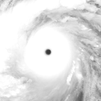
10 years ago today, one of the most extreme rapid intensification episodes in our historical record was unfolding in the Pacific, as #Patricia wrecked the western hemisphere wind and pressure records (and then some). It then rapidly weakened at an even faster pace into Mexico.
Ten-year anniversary of Hurricane #Patricia Patricia has finally reached its historic peak. The NHC estimates 185 kt/872 mbar, but I suspect it may have been in the 860s. Increasing shear, land interaction and an ERC will now cause weakening till landfall in a few hours.

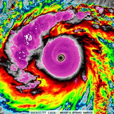
Hurricane #20L #Patricia 10-year Anniversary Satellite: #NOAA19 #AVHRR3 Channel : B04 (10.8 µm) 1.1 km Time : 2015/10/23 0918Z Eye Temp : 23.539 °C CPA : ~390 km Aircraft Observation : 0646Z 885mb/41kt FL 192KT


Ten-year anniversary of Hurricane #Patricia Patricia is now at an intensity seen scarcely before: the final data from the USAF recon aircraft before leaving supports 175-180 kt, with a pressure ~880 mbar and dropping 7 mbar/hr! But time is running out for intensifying...

Hurricane #20L #Patricia 10-year Anniversary Satellite: #TERRA #MODIS Channel : B27 (6.7 µm) B31 (11.03 µm) 1-km Time : 2015/10/23 0518Z Eye Temp (IR) : 25.67 °C Eye Temp (WV) : -11.01 °C CPA : ~100 km Aircraft Observations : 0601Z 890mb/40kt FL 180KT 0646Z 885mb/41kt FL 192KT


United States Trends
- 1. #RHOP 4,563 posts
- 2. Chargers 13.5K posts
- 3. Rams 27.2K posts
- 4. Jassi 1,265 posts
- 5. #HereWeGo 3,063 posts
- 6. Commanders 119K posts
- 7. Seahawks 32.9K posts
- 8. Canada Dry 1,535 posts
- 9. Lions 94.2K posts
- 10. 49ers 22.1K posts
- 11. DO NOT CAVE 15K posts
- 12. Jordan Walsh N/A
- 13. Stafford 10.5K posts
- 14. Khalil Mack N/A
- 15. Lenny Wilkens 4,397 posts
- 16. Tim Kaine 3,577 posts
- 17. Dan Campbell 3,950 posts
- 18. Niners 5,502 posts
- 19. #90DayFianceHappilyEverAfter N/A
- 20. Gizelle N/A
You might like
-
 Southwest Florida Storm Chaser
@SWFLWX -
 Angelic Panda Meteorology
@APGMeteorology -
 Speak Freely
@SpeakFreely2222 -
 Maclovio Perez
@macloviop70 -
 Kacper
@KacperWx -
 Stormfury
@stormyday200 -
 SuperTyphoon Tracker
@ecal_im -
 DMVwx
DMVwx
@DMVweatherplus -
 Emmanuel Enriquez
@WXappraiser -
 No clue
@TheHappyWxGuy -
 xiaoqianWX
@xiaoqianWX -
 Imran Mahmood
@doomhaMwx -
 我不是Carl2
@Carl225126302 -
 Paul Ell
@paulell90 -
 Jagger
@JAG6286
Something went wrong.
Something went wrong.