
You might like


Newly elected #NASmember Geoffrey Blewitt of @NVGeodeticLab conducts research in wide-ranging subjects, including geodesy and #geophysics, and the search for dark matter and multi-messenger #astrophysics. Read more: ow.ly/rBag50UrYEA
New book alert! I edited this book with @yoaoki on the various applications of #GNSS for natural hazards. Published by @ElsevierConnect, it contains many focused chapters by experts in the field. shop.elsevier.com/books/gnss-mon…

Nice story from @vtnews about a recent paper published with @GeodesyRules ! news.vt.edu/content/news_v… @vtgeosciences @vtgeosciences @VTSandsman @VT_Science @EarthScope_sci

Thanks to #GNSS data from the Central Weather Administration of Taiwan, we now have coseismic offsets for the M7.4 Hualing City #earthquake at geodesy.unr.edu
We have coseismic #GPS displacements for the M7.5 New Year’s Day Japan #earthquake on our website geodesy.unr.edu
We are looking for a postdoc to work on the new Global Strain Rate Model @earth_jobs @EarthSci_Jobs Position for 2.5+ years, starting at earliest convenience. GNSS time-series and ideally InSAR experience a plus, as well as good coding skills. Contact @GeodesyRules for more info.

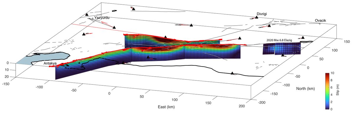
Smooth estimate of the slip distribution for the Turkey-Syria earthquake sequence from GPS data provided by @NVGeodeticLab. Fault slip confined above 10 km depth, tapering near segment boundaries. There is a wide gap between the 2020 Mw 6.8 Elâzığ and 2023 ruptures.
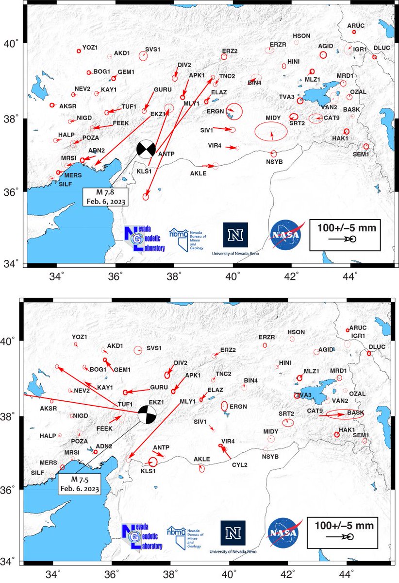
With help from Prof. Ugur Sanli, #gnss data has been obtained from some @tusaga_actif network stations near the epicenters of the recent #TurkeySyriaEarthquakes. Solutions are available at geodesy.unr.edu. Coseismic displacements from 5 minute samples shown below.
New paper alert: GPS measurements show 0.5-0.6 mm/yr of extension across Las Vegas Valley. Seismic hazard is larger than previously realized. Results sensitive to postseismic deformation from large plate boundary earthquakes. #lasvegas @SeismoSocietyAm pubs.geoscienceworld.org/ssa/bssa/artic…
NGL website is back online! We apologize for the inconvenience you may have had.
Our back-up server is now also down. It has been a very unfortunate couple of weeks for the NGL website. Hopefully we got it fixed soon.
Our website, and all of its data products, is back online.
Our website geodesy.unr.edu is currently down. We apologize for the inconvenience. We are working hard to have it up and running again.
Measuring Sea Level Rise Along the Coast - Eos eos.org/research-spotl…
New publication alert. First paper by our Ph.D. student Zack Young. Congrats! agupubs.onlinelibrary.wiley.com/doi/abs/10.102…

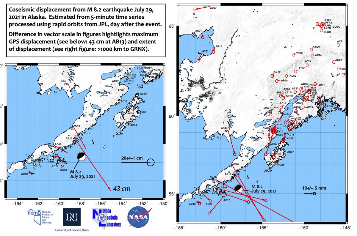
Whopper M8.2 earthquake in Alaska moved GPS stations, revealing the broad pattern and extent of deformation. Stations near Denali NP ~900 km moved a few mm... See geodesy.unr.edu for more info and data.
First coseismic GPS offsets for the M6 Walker Earthquake are coming in, including for our own stations. Station LANT was right above the hanging wall (!) and subsided 10 cm. geodesy.unr.edu
It took a new 30+ GPS station network, 10 years of measurements, and figuring out how to best deal with all those darn California earthquakes, but here it is; our best estimate of time-invariant extension rates across Arizona; spoiler alert, it ain’t zero. agupubs.onlinelibrary.wiley.com/doi/10.1029/20…
Our analysis of vertical land motion of GPS stations in North America helped put, when combined with the ice history of the last glaciation, some firm constraints on the viscosity of the upper third of the lower mantle. The power of geodesy! agupubs.onlinelibrary.wiley.com/doi/10.1029/20…
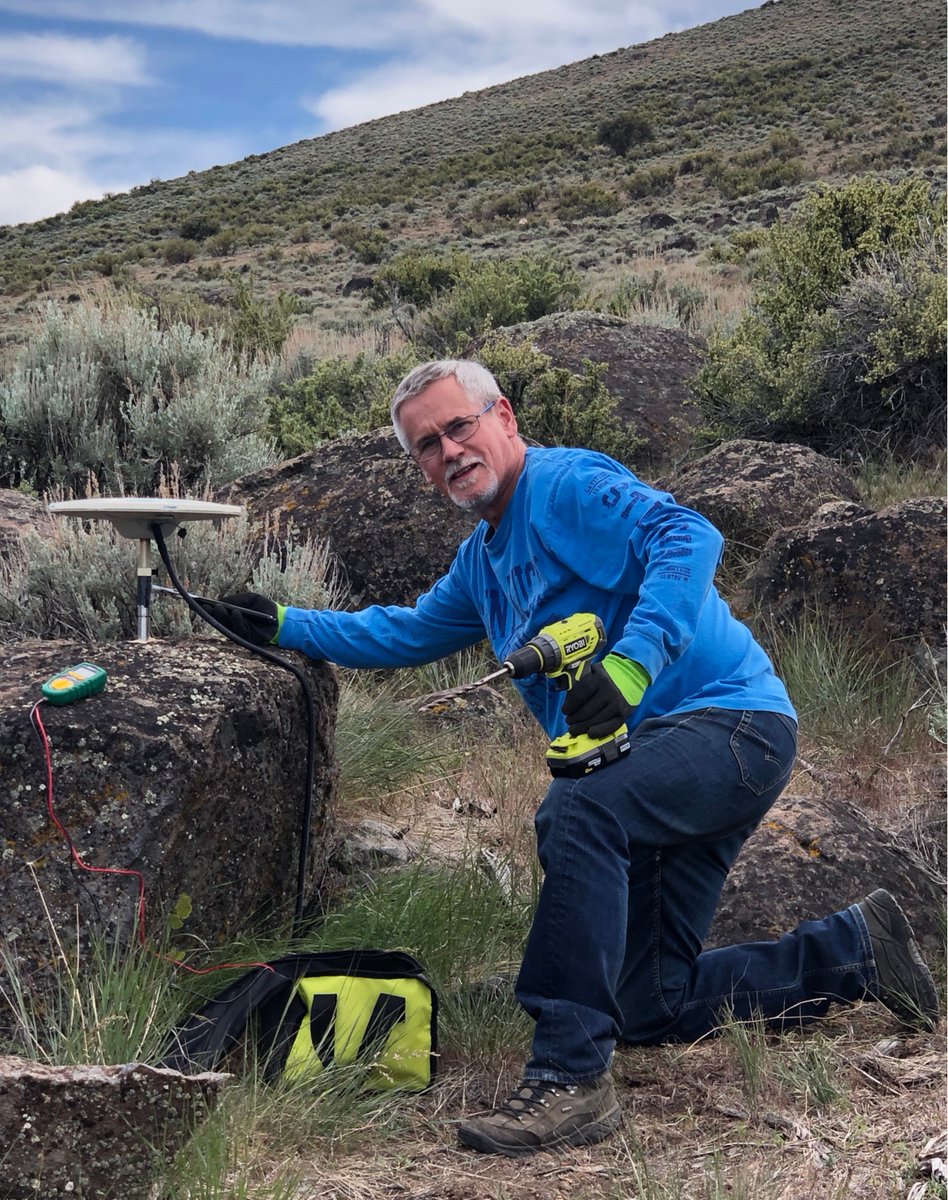
Our latest two stations were installed at the San Emidio geothermal area (south of Gerlach, NV) to constrain vertical land motion and aid in the interpretation of #insar data of surface motion during variable phases of water injection and production.


United States Trends
- 1. FINALLY DID IT 148K posts
- 2. The JUP 101K posts
- 3. Christmas 2.93M posts
- 4. The PENGU 46.7K posts
- 5. #StrangerThings5 354K posts
- 6. Kwanzaa 59.5K posts
- 7. Utah 38.3K posts
- 8. Nigeria 523K posts
- 9. Vecna 159K posts
- 10. Marty Supreme 29.8K posts
- 11. Boxing Day 837K posts
- 12. Kyle Whittingham 24.6K posts
- 13. $luna 1,732 posts
- 14. #SmackDown 28.8K posts
- 15. Dustin 145K posts
- 16. Jokic 44.7K posts
- 17. Somaliland 164K posts
- 18. Jesus 449K posts
- 19. Minnesota 586K posts
- 20. FaZe 33.4K posts


Something went wrong.
Something went wrong.