
你可能会喜欢


Scattered to widespread frost is expected tonight and tomorrow night. Frost tonight will be focused in Newaygo, Mecosta, Isabella, Clare, Osceola, and Lake counties. Wednesday night frost is likely across the entire area. #miwx #wmiwx

Severe Thunderstorm Warning including Ionia MI, Portland MI and Lowell MI until 9:30 PM EDT

A special weather statement has been issued for Hastings MI, Allegan MI and Otsego MI until 9:15 PM EDT

Severe Thunderstorm Warning including Cutlerville MI, Byron Center MI and Wayland MI until 9:00 PM EDT

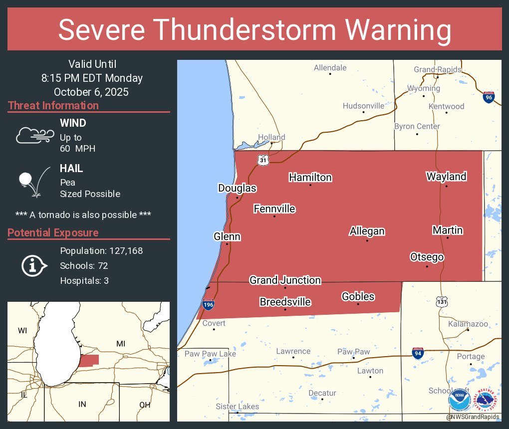
Severe Thunderstorm Warning including Allegan MI, South Haven MI and Wayland MI until 8:15 PM EDT
Special Marine Warning including the Lake Michigan from South Haven to Holland MI 5NM offshore to Mid lake, Lake Michigan from St Joseph to South Haven MI 5NM offshore to Mid Lake, St Joseph to South Haven MI and South Haven to Holland MI until 7:45 PM EDT

Special Marine Warning continues for the Lake Michigan from South Haven to Holland MI 5NM offshore to Mid lake, Lake Michigan from Holland to Grand Haven MI 5NM offshore to Mid Lake and Lake Michigan from St Joseph to South Haven MI 5NM offshore to Mid Lake until 7:15 PM EDT
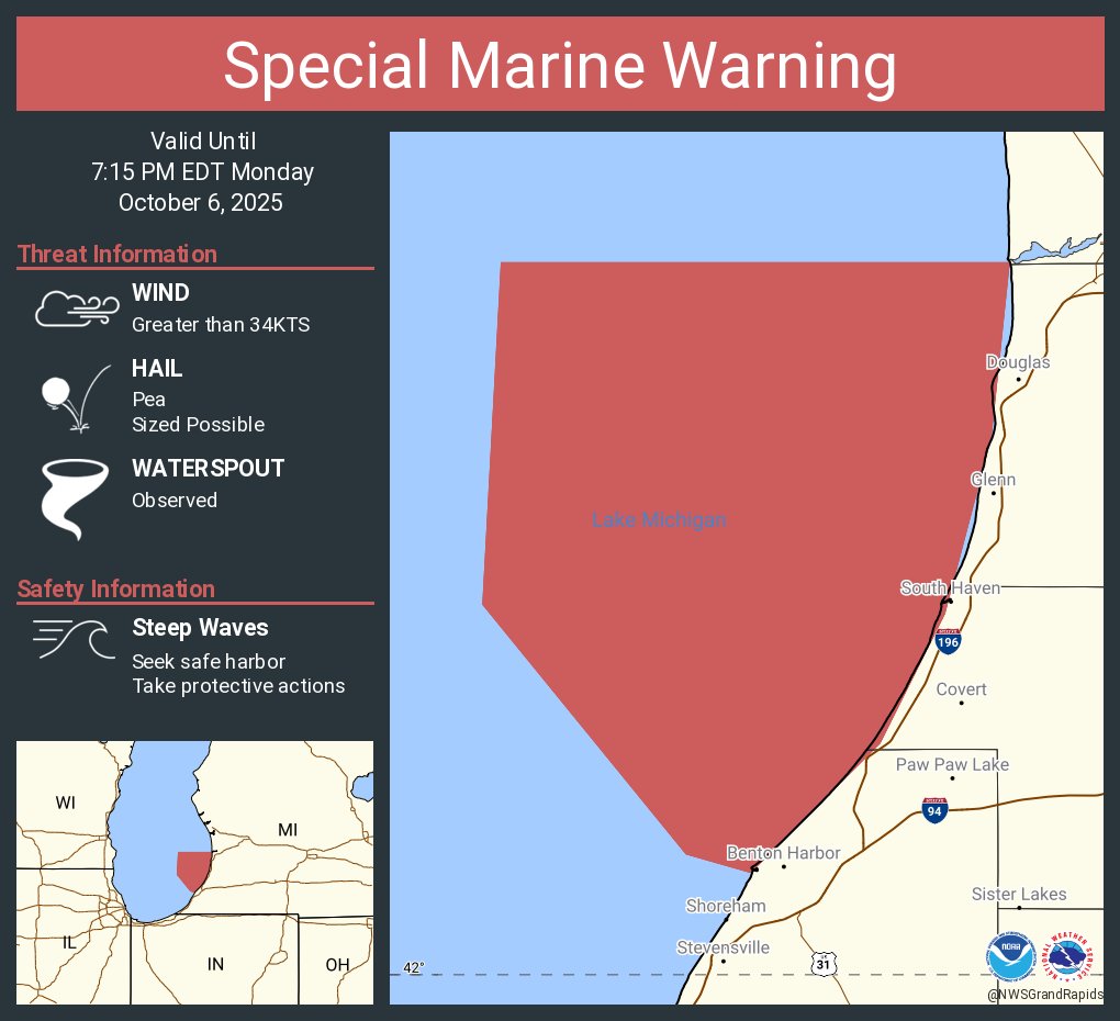
Special Marine Warning including the Lake Michigan from South Haven to Holland MI 5NM offshore to Mid lake, Lake Michigan from Holland to Grand Haven MI 5NM offshore to Mid Lake and Lake Michigan from St Joseph to South Haven MI 5NM offshore to Mid Lake until 7:15 PM EDT

Increasing southwest winds will build waves into the 3-6 foot range from this afternoon into Monday afternoon from Saugatuck north to Ludington. South sides of south piers will be dangerous places to swim. Stay dry when waves are high.
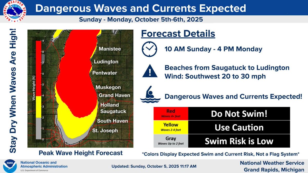
Heads up for dangerous swimming conditions developing on Sunday along Lake Michigan beaches from Grand Haven to Ludington! Stay dry and stay safe!

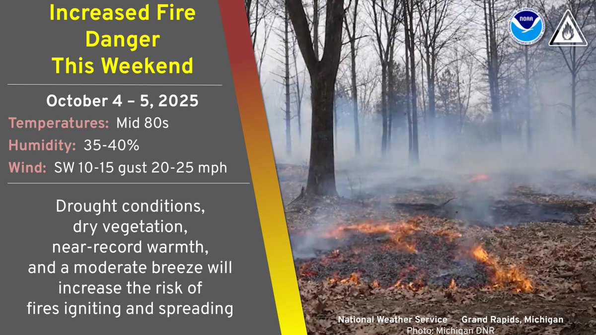
Wildfire and field fire danger is elevated this weekend in much of the Lower Peninsula. Be extra cautious as fires can ignite and spread more easily under these conditions.
Episodic thunderstorms the past three days resulted in patches 1.5 to 4 inches of rain in West Michigan. The Holland area had 3 to 4 inch totals the last three days, a big turnaround compared to the 4 to 5 inch totals from the entire three-month span of June, July, and August.

A special weather statement has been issued for Battle Creek MI, Charlotte MI and Springfield MI until 12:15 PM EDT

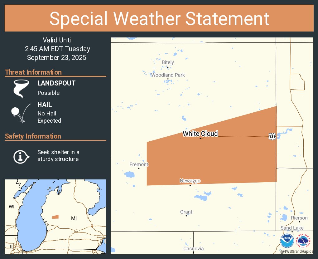
A special weather statement has been issued for White Cloud MI until 2:45 AM EDT
A special weather statement has been issued for Kalamazoo MI, Westwood MI and Eastwood MI until 5:15 PM EDT

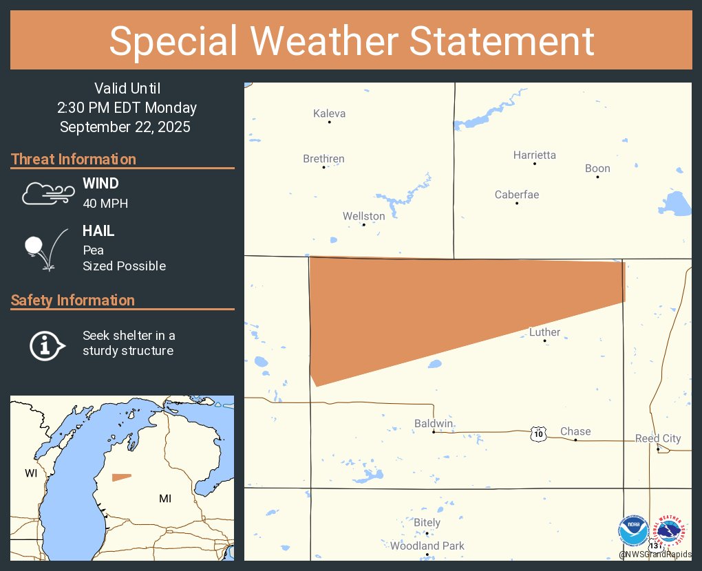
A special weather statement has been issued for Lake County, MI until 2:30 PM EDT
A special weather statement has been issued for Ludington MI, Scottville MI and Custer MI until 8:30 AM EDT

A special weather statement has been issued for Battle Creek MI, Marshall MI and Springfield MI until 11:00 PM EDT

Severe Thunderstorm Warning including Paw Paw MI and Mattawan MI until 8:45 PM EDT

Here is a precipitation map from yesterday's rainfall. Mainly beneficial rains across the region with a strip of higher rainfall just north of Lansing through southern Clinton county.


United States 趋势
- 1. Auburn 27.3K posts
- 2. Brewers 36.8K posts
- 3. Georgia 58.2K posts
- 4. Kyle Tucker 2,203 posts
- 5. Michigan 57.7K posts
- 6. Penn State 26.8K posts
- 7. Kirby 12.9K posts
- 8. #UFCRio 52.9K posts
- 9. Nuss 5,221 posts
- 10. #ThisIsMyCrew 2,292 posts
- 11. Billy Napier 2,190 posts
- 12. Sherrone Moore 1,276 posts
- 13. Indiana 48.5K posts
- 14. Hugh Freeze 1,505 posts
- 15. James Franklin 14.1K posts
- 16. Andrew Vaughn 1,511 posts
- 17. Chad Patrick N/A
- 18. #MagicBrew 5,407 posts
- 19. Charles 109K posts
- 20. Diane Keaton 220K posts
你可能会喜欢
-
 City of Grand Rapids
@CityGrandRapids -
 NWS Detroit
@NWSDetroit -
 NWS Gaylord
@NWSGaylord -
 MDOT - West Michigan
@MDOT_West -
 WOOD TV8
@WOODTV -
 FOX 17
@FOX17 -
 13 On Your Side
@wzzm13 -
 NWS LMRFC
@NWSLMRFC -
 Grand Rapids Press
@GRPress -
 NWS OHRFC
@NWSOHRFC -
 Grand Rapids Police
@GrandRapidsPD -
 Bill Steffen
@bsteffen -
 DowntownGRInc
@DowntownGRInc -
 Michigan DOT
@MichiganDOT -
 Experience Grand Rapids
@ExperienceGR
Something went wrong.
Something went wrong.