

245 PM: We are closely monitoring thunderstorms in central MS which will move ENE into NW & NC AL over the next 1-3 hours. Intensification is expected w/this line of thunderstorms with large hail and damaging winds primary threats, but tornadoes remain a risk as well. #HUNwx

Here is an afternoon look at the Alabama/Deep South weather situation for tonight: youtube.com/live/B82prqI99…
youtube.com
YouTube
James Spann's Afternoon Briefing - Tuesday 4.2.24
Timing for the thunderstorms moving into Alabama late tomorrow/tomorrow night…


No, this is NOT an April Fool's Joke! Confidence is increasing that a significant winter storm will bring heavy snow and gusty winds to portions of the Great Lakes and Northeast later this week. Please stay tuned for forecast updates the next few days.


Large powerful storm systems that could unleash tornadoes, thunderstorms and hail are expected to hit the Central U.S. on Monday before moving east, forecasters said. nyti.ms/49lGIMd
nytimes.com
Storms Lash Parts of Central U.S. (Published 2024)
A powerful storm system struck sections of Missouri, Oklahoma and Texas before moving east, forecasters said.
[8 AM] Severe thunderstorms capable of producing damaging winds, large hail and a few tornadoes are expected to occur across the Lower TN Valley Tuesday afternoon/evening. Please ensure that you have multiple methods to receive weather information. #HUNwx
![NWSHuntsville's tweet image. [8 AM] Severe thunderstorms capable of producing damaging winds, large hail and a few tornadoes are expected to occur across the Lower TN Valley Tuesday afternoon/evening. Please ensure that you have multiple methods to receive weather information. #HUNwx](https://pbs.twimg.com/media/GKFQ4fobIAA_tzq.jpg)
![NWSHuntsville's tweet image. [8 AM] Severe thunderstorms capable of producing damaging winds, large hail and a few tornadoes are expected to occur across the Lower TN Valley Tuesday afternoon/evening. Please ensure that you have multiple methods to receive weather information. #HUNwx](https://pbs.twimg.com/media/GKFQ5l7aAAANb9j.jpg)
If you are in these areas, stay weather aware, and have a plan. This will have some seriously dangerous hail.

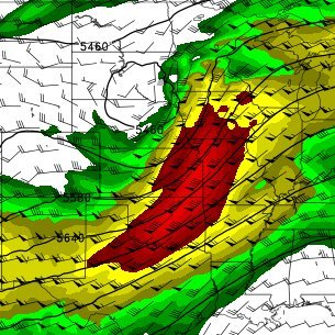
SPC maintains Enhanced Risk (level 3/5) for Mon 4-1 across parts of OK/KS/AR/MO. Initial supercells expected to quickly morph into squall line w/ all hazards possible, especially large hail in the stronger cores and sig damaging wind. Threat shifts east on Tues 4-2. Video later!


The Storm Prediction Center has added a day 3 (Monday) ENHANCED RISK from central OK through a large part of MO! This is an all hazards risk, including the threat of tornadic supercells.


7:35pm CDT #SPC Day1 Outlook Marginal Risk: across the West Virginia area spc.noaa.gov/products/outlo…

A severe thunderstorm watch has been issued until 10 PM EDT for central to eastern Ohio and far northwest West Virginia. Thunderstorms will be capable of severe hail (up to ping-pong ball sized) and severe winds. #OHwx #WVwx


SOUNDING THE ALARM: Goldman Sachs CEO says high inflation is here to stay, even if the feds cut interest rates. trib.al/IhkQJdk

Low pressure along a stationary front in Texas will pose a threat of severe thunderstorms and flash flooding this afternoon into tonight. Meanwhile, a deep upper low over the Southwest will continue heavy snow chances in the high elevations of the Four Corners region.

12:27pm CDT #SPC Day2 Outlook Marginal Risk: from central Texas eastward along the central Gulf Coast spc.noaa.gov/products/outlo…

7:48am CDT #SPC Day1 Outlook Enhanced Risk: through late evening across parts of south central TX spc.noaa.gov/products/outlo…


Transmission towers collapsed after a strong tornado near Delaware, Ohio last night. Fully collapsed transmission towers like this are typically a low-end EF3 damage indicator (140 mph). Photos: dispatch.com/picture-galler…


What a textbook tornadic supercell tonight near Alta Vista, KS. I was on this storm and was able to document the broad multi-vortex tornado it produced. Will have this up sometime in the near future as a vlog in which I’ll explain my thought process throughout my chase!


*TWIN TORNADOES* This video was taken by Jaylnne Dutton in southern Hancock County near Vanlue.
Tornado Warning continues for Waterloo IL and Maeystown IL until 5:00 PM CDT


United States الاتجاهات
- 1. Black Friday 363K posts
- 2. #SkylineSweeps N/A
- 3. #FanCashDropPromotion 1,305 posts
- 4. NextNRG Inc 1,352 posts
- 5. WHO DEY 5,347 posts
- 6. Egg Bowl 3,241 posts
- 7. Good Friday 61.5K posts
- 8. mainz biomed n.v. N/A
- 9. #LightningStrikes N/A
- 10. #NutramentHolidayPromotion N/A
- 11. #FridayVibes 4,360 posts
- 12. Andriy Yermak 13.9K posts
- 13. Clark Lea 1,232 posts
- 14. Mr. President 22.5K posts
- 15. Cyber Monday 6,241 posts
- 16. Black Cats 3,047 posts
- 17. TODAY ONLY 65.6K posts
- 18. CONGRATULATIONS JIN 62K posts
- 19. Wegmans 2,881 posts
- 20. CONGRATULATIONS J-HOPE 53.6K posts
Something went wrong.
Something went wrong.