
You might like


They are using #RGPR to predict log moisture content of commercially important canadian softwoods! I. Duchesne, Q. Tong and Guillaume Hans Link to their publication: mdpi.com/1999-4907/14/1…
What could be more rewarding than the US Army Corps of Engineers using #RGPR for automated ground-penetrating radar data processing? Check this publication from the US Army Corps of Engineers: erdc-library.erdc.dren.mil/jspui/bitstrea…
Last week, #RGPR hit the 100 stars mark on GitHub. A great step for a little open-source project whose journey started in June 2015. I am very thankfull for all the support, feedback, contacts, requests, and contributions I got. I am looking forward to continuing this journey.

Thank you Hugo Rodrigues, Gustavo de Mattos, Flavio Adriano Marques, Maria Sonia Lopes da Silva for this great collaboration: Ground penetrating radar (GPR) models of the regolith and water reservoir of an underground dam in the Brazilian semiarid region doi.org/10.1016/j.japp…

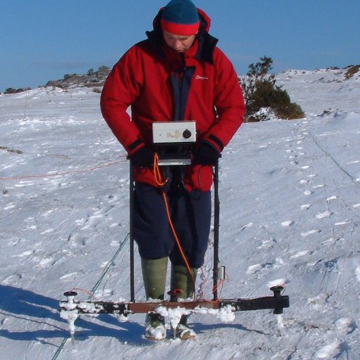
Looking at #GPR data from #holyisland in #googleearth - Scotland in the background. Where did the water flow from the Lough into the sea before they built modern drainage ditches? 🤔@arcdurham @thedigventurers @DrMWdeGruchy @IapetusDTP @surveylikeagirl @medcaut @NTlindisfarne

Experiments with Ground Penetrating Radar #GPR data from #lindisfarne in @RGPRsoftware. It will help us to understand the extent of buried landscape features we have identified in sediment cores. @ArcDurham @DurUniEarthSci @TheDigVenturers @IapetusDTP @dunchale @surveylikeagirl

RGPR now supports @gprMax_fdtd file format (*.out). RGPR is a free and open-source software package written in R language to read, visualize and process ground-penetrating radar data. emanuelhuber.github.io/RGPR/

#RGPR now supports the Transient Technologies LLC file format (*.sgpr)! RGPR is a free and open-source software package #R language) for #GPR data visualization and processing.

Check out my latest article: Advective mixing in groundwater linkedin.com/pulse/advectiv… via @LinkedIn

#RGPR: New tutorial on how to fit hyperbola to interactively selected points in ground-penetrating radar (#GPR) data. Link to the tutorial: emanuelhuber.github.io/RGPR/07_RGPR_t… Any comments and suggestions are highly appreciated and will contribute to improve RGPR.

#RGPR now supports the GroundVue 100, 250 and 400 file format from Geomatrix Earth Science Ltd (*.dat, *.hdr). Many thanks to Geomatrix Earth Science Ltd for their support! List of all file formats supported by RGPR: emanuelhuber.github.io/RGPR/#notes

RGPR now partially supports Utsi GPR data file format. The file formats for the GroundVue100, 250 and 400 will be soon supported. Many thanks to Geomatrix Earth Science Ltd @GeomatrixES for sharing the file format. Tutorial how to import GPR data in RGPR: lnkd.in/e_xbPDw


RGPR received the Best Poster Award at the 17th International Conference on Ground-penetrating Radar in Rapperswil linkedin.com/pulse/rgpr-rec…

RGPR - a free and open-source software package to process and visualise ground-penetrating radar (GPR) data. linkedin.com/pulse/rgpr-r-p…


United States Trends
- 1. Good Saturday 20.3K posts
- 2. #MeAndTheeSeriesEP1 247K posts
- 3. Wemby 44.5K posts
- 4. Draymond 21.8K posts
- 5. #SaturdayVibes 3,185 posts
- 6. Steph 85K posts
- 7. #PerayainEFW2025 157K posts
- 8. FAYE ATTENDS SILHOUETTE EFW 151K posts
- 9. Massie 64.5K posts
- 10. #Truedtac5GXWilliamEst 197K posts
- 11. Spurs 35.6K posts
- 12. Bubba 63K posts
- 13. Marjorie 74.2K posts
- 14. PERTHSANTA JOY KAMUTEA 643K posts
- 15. #NEWKAMUEVENTxPerthSanta 639K posts
- 16. Warriors 60.9K posts
- 17. Alignerz 194K posts
- 18. Zack Ryder 18K posts
- 19. Charlie Brown 2,934 posts
- 20. Metroid 18.9K posts
You might like
Something went wrong.
Something went wrong.