Traffic/News
@SpringfieldMo10
Traffic information for Springfield and the surrounding area.
Talvez você curta


Man dies in overnight crash on I-44 in Lawrence County: ky3.com/2020/09/20/man…
ky3.com
Man dies in overnight crash on I-44 in Lawrence County
One man died in an overnight crash on Interstate 44 in Lawrence County, while another woman suffered serious injuries.
A fatal car accident has left one dead and a teen passenger seriously injured. - bit.ly/3i0WC4I
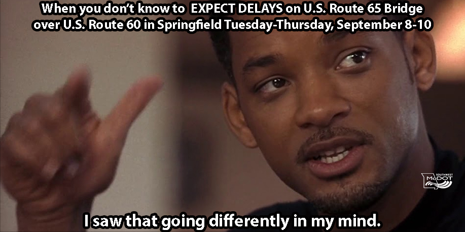
Northbound U.S. 65 left lane closed at bridge over U.S. 60 in southeast #Springfield from 9 a.m. Tues, Sept 8, until as late as 8 p.m. Thurs, Sept 10 as crews clean and seal the bridge deck/driving surfaces on northbound U.S. 65 bridge over U.S. 60. #MoDOTSW #Hitch #SGFD

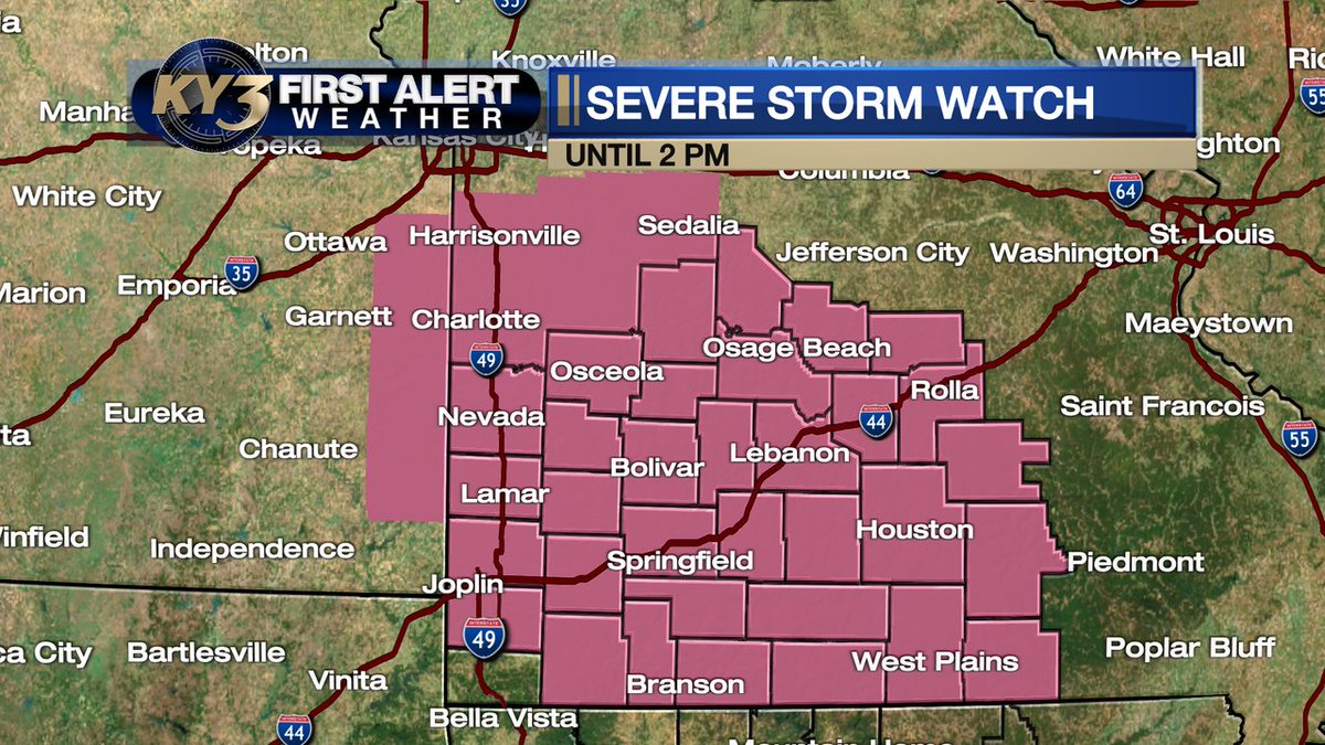
FIRST ALERT WEATHER: JUST ISSUED...A #SEVERE THUNDERSTORM WATCH is up for all of southern and central Missouri until 2 pm. Storms coming at us from the Kansas City area will pack high winds from mid-morning in central Missouri into the early afternoon over southern #Missouri.
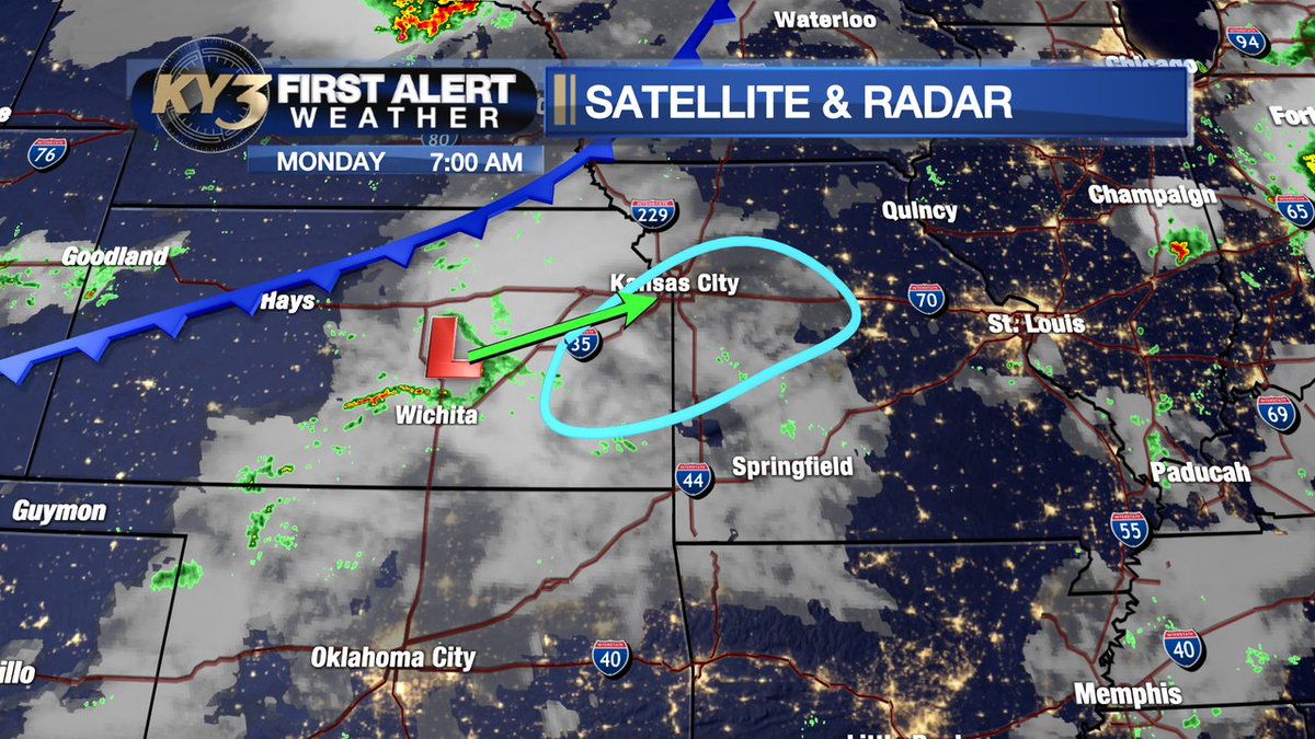
FIRST ALERT WEATHER: While various models handle the timing differently, I think storms are possible by early afternoon across parts of central Missouri as an upper low moves toward the Kansas City area. High wind and large hail are possible. Stay aware of the sky today!
Small cluster of showers and thunderstorms will track across southern Missouri this evening.

Strong storms with gusty winds up to 40mph, lightning, and heavy rain all possible overnight! #mowx
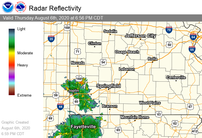
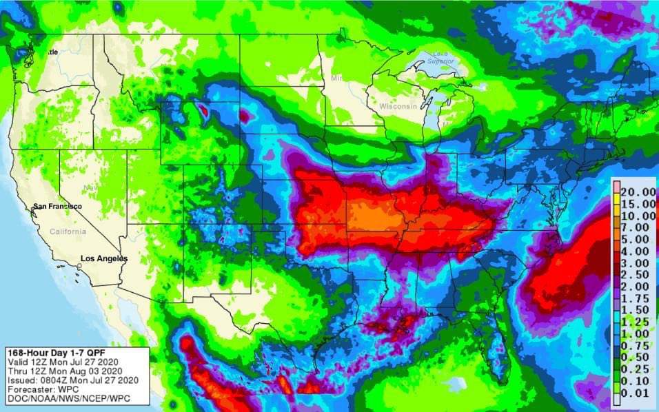
Showers and storms will move through the area tonight through Thursday. Many areas can handle a few inches of heavy rainfall without problems, however some flooding may still be possible given the terrain, mainly along and south of Interstate 44. #sgf #mowx #ozarkswx
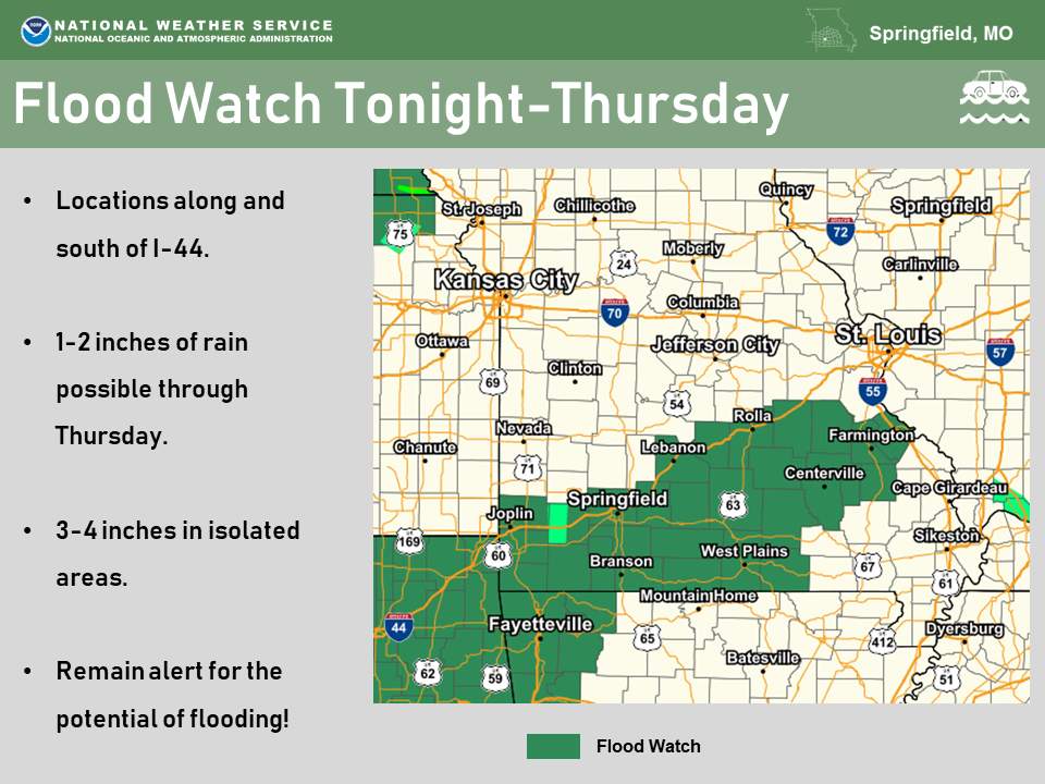
Excessive rain and flooding potential increases as the week progresses.
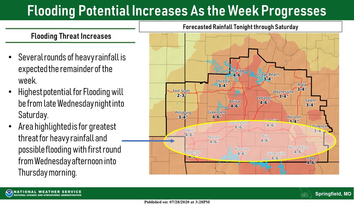

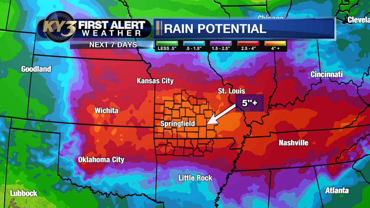
Rain totals might become an issue this week. The totals won't be as uniform as most accumulation projections due to locally heavier downpours. That said... the saying "when it rains it pours" applies this week and upwards of 4"+ will be a possibility.
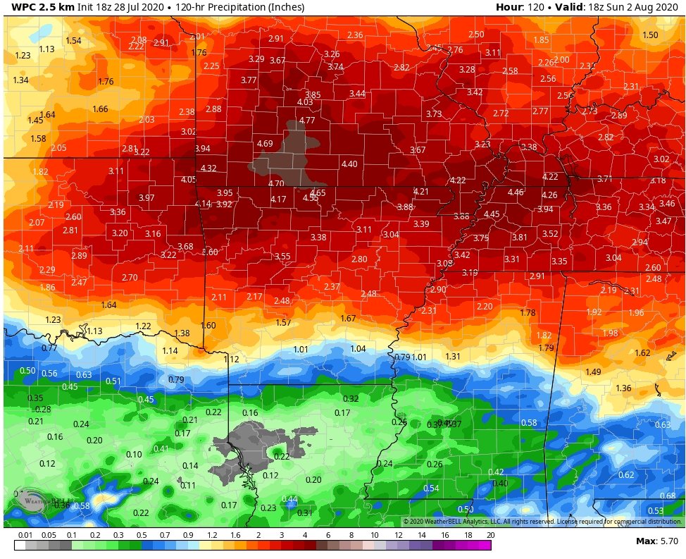
FIRST ALERT WEATHER: Oh boy, this could be a heck of a turn-around compared to recent hot/dry weather. A meandering front and tropical-like moisture will lead to the chance of multiple rounds of storms this week. Rain totals may top 5" in spots by the end of the week! #Ozarks
FIRST ALERT WEATHER: Iso. storms Sunday with better rain chances this week.
Woman dies, another seriously injured in St. Clair County, Mo. crash: ky3.com/2020/07/25/wom…

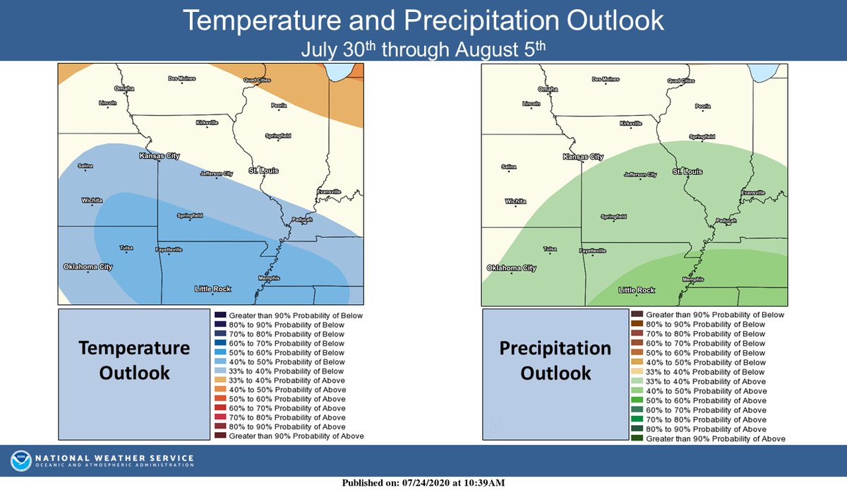
Increased chances for below normal temperatures and above normal precipitation July 30th - August 5th. #mowx #kswx

Police identify Springfield man killed in Rogersville crash ktts.com/2020/07/22/pol… @KTTSNews
ktts.com
Police Identify Driver Killed In Rogersville Crash
Share on Facebook Share on Twitter Police have identified the driver who was killed in a wrong-way crash west of Rogersville. Larry Smith, 73, was from Springfield. Police say Smith was going the...
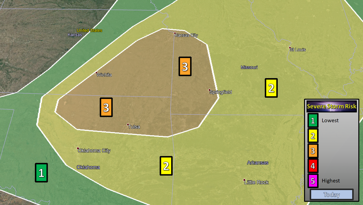
While widespread severe weather is not expected a few stronger storms will be possible during the late morning. As is the case now with a storm over Highlandville that is capable of producing up to half inch size hail and very heavy downpours.
95% chance of a severe thunderstorm watch coming out soon for this area in SE Kansas and SW Missouri! Ongoing supercell in NE Kansas is ongoing with potential for outflow boundary storms on the west edge of ongoing storms. #mowx #kswx


Severe weather risk in the Ozarks today and tonight: tedwkeller.com/2020/07/11/sev…

UPDATE: A KC area child who was the subject of an Amber Alert issued today has been found dead.


United States Tendências
- 1. Eagles 233 B posts
- 2. #GoldenGlobes 727 B posts
- 3. AJ Brown 30,3 B posts
- 4. Jalen 32,5 B posts
- 5. Niners 26,4 B posts
- 6. Patullo 36,4 B posts
- 7. Patullo 36,4 B posts
- 8. Philly 44,2 B posts
- 9. Chargers 39,6 B posts
- 10. Purdy 23,5 B posts
- 11. Powell 50,4 B posts
- 12. #FTTB 13,3 B posts
- 13. Teyana 29,8 B posts
- 14. Kittle 28 B posts
- 15. Nikki Glaser 7.127 posts
- 16. ariana 105 B posts
- 17. Super Bowl 8.703 posts
- 18. Patriots 117 B posts
- 19. Kyle Shanahan 8.190 posts
- 20. Howie 3.389 posts
Talvez você curta
-
 MoDOT Southwest
@MoDOT_Southwest -
 City Utilities
@cityutilities -
 Greene County MO
@GreeneCountyMO -
 Springfield PD
@SGFPolice -
 OzarksFirst
@ozarks_first -
 NWS Springfield
@NWSSpringfield -
 Ozarks Food Harvest
@ozksfoodharvest -
 Chief Paul Williams
@chief_spd -
 United Way Ozarks Region
@UWOzarks -
 Community Partnership of the Ozarks
@CPOzarks -
 KY3 News
@kytv -
 Chase Beal-Sharp
@Thunderguad15 -
 Springfield's Talk 104.1
@1041KSGF -
 KY3 First Alert Weather
@KY3StormTeam -
 Greg Burris
@GregBurrisSGF
Something went wrong.
Something went wrong.