
你可能會喜歡


Good news! We're no longer looking at flooding concerns out on Hwy-80 based of the latest forecast. #stayupdated #savannahga
We'll look for more beautiful sunny weather returning to the area throughout most of next week. #savannahga #thisweek

Be extra careful moving around the area tomorrow as we track more scattered shower and gusty winds throughout the day. #sunday #savannahga

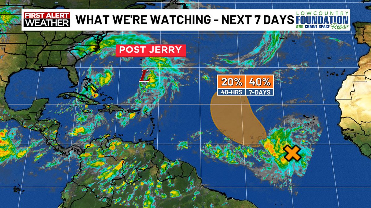
Jerry has now fallen apart. However, we're watching a new area with a 40% of forming into a tropical system within the next 7 days. #stayupdated


Water is on Highway 80 between Tybee Island and the Bull River Bridge. The tide peaked at 10.35’ at 11:36AM. Video credit to CEMA
At 10.35', today's high tide is the 8th highest on record at Fort Pulaski!

The marsh is filling up ahead of high tide at 11:07AM! With an expected high tide of 10.3' we could see water on Highway 80 between Tybee Island and the Bull River Bridge.

This morning's high tide will be the highest of the week! When the tide rises over 10', we could see water on Highway 80 between Tybee Island and the Bull River Bridge.

Grab your rain gear if you are heading to the Tybee Island Pirate Fest this weekend! It'll be breezy, especially today and tomorrow. 🏴☠️

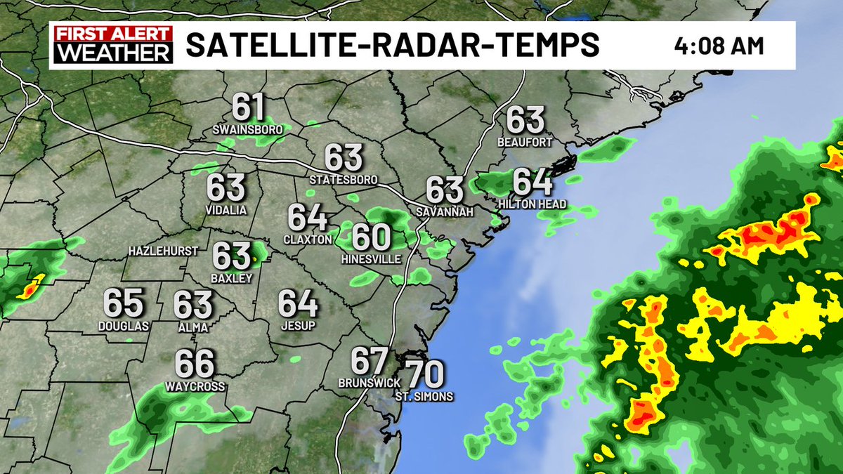
Spotty showers are leading to damp roads this morning with cooler temperatures than yesterday!
This morning’s high tide is moving the channel marker on Tybee Island! The U.S. Coast Guard and U.S. Army plan to retrieve the channel marker by helicopter around 4 PM. They’ll have to face 30+ mph wind gusts in the process. 🎥: Brent Levy
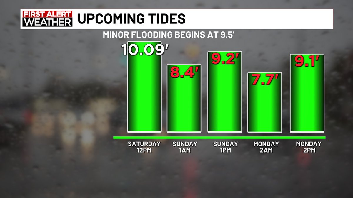
Tides will remain elevated through Saturday with the highest tide expected around 11AM on Friday.
Tropical Storm #Jerry is expected to strengthen into a hurricane by Thursday afternoon as it passes to the east of the northern Leeward Islands.

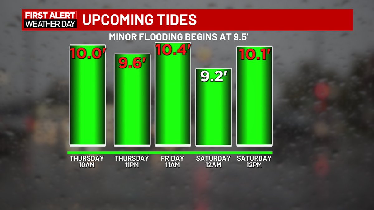
High tides remain a concern over the next few days, especially Thursday and Friday morning. Water could briefly cover Highway 80 between Tybee Island and the Bull River Bridge.

Tropical Storm #Jerry has formed in the Atlantic. Jerry could become a hurricane Wednesday evening as before making a close pass to the Northern Leeward Islands.

We could have our next tropical depression today as Invest #95-L continues to become organized. The northern Leeward Island should monitor this system as impacts are possible during the end of this week.

Tides will remain elevated through Thursday! Coastal flooding will be possible an hour before and after high tides. If Thursday morning's high tide verifies, we could see water on Highway 80 between Tybee Island and the Bull River Bridge.


We're now looking at tide level forecasted around 10' tomorrow morning. Any tide above 10′ can cause travel issues along Highway 80 between the Bull River Bridge and Tybee Island. #stayupdated #savannahga #tomorrowmorning


United States 趨勢
- 1. Jets 105K posts
- 2. James Franklin 39.6K posts
- 3. Drake Maye 11.9K posts
- 4. Justin Fields 21K posts
- 5. Penn State 54.6K posts
- 6. Broncos 44.8K posts
- 7. Puka 7,498 posts
- 8. Aaron Glenn 8,861 posts
- 9. Derrick Henry 2,517 posts
- 10. Rico Dowdle 2,535 posts
- 11. #RavensFlock 1,860 posts
- 12. George Pickens 4,164 posts
- 13. Steelers 43K posts
- 14. Cooper Rush 1,901 posts
- 15. Saints 47.8K posts
- 16. #DallasCowboys 2,316 posts
- 17. Cam Little N/A
- 18. Eberflus 1,091 posts
- 19. #RamsHouse 1,248 posts
- 20. #KeepPounding 2,149 posts
你可能會喜歡
-
 wtoc11
@WTOC11 -
 WJCL News
@WJCLNews -
 WSAV News 3
@WSAV -
 WTOC David Turley
@WtocDave -
 City of Savannah
@cityofsavannah -
 Savannah Now
@SavannahNow -
 Savannah Police Department
@SavPolice -
 Savannah City Market
@SavCityMarket -
 WTOC Jamie Ertle
@wtocjamie -
 Chatham EMA
@ChathamEMA -
 Hilton Head Island
@TownofHHI -
 Mayor Van Johnson
@MayorJohnsonSAV -
 WTOCtraffic
@TrafficWTOC -
 Savannah-Chatham County Public Schools
@SCCPSS -
 Savannah's Waterfront
@savwaterfront
Something went wrong.
Something went wrong.