Toby ⛈️🌨️
@WeatherToby
Toby | Christian | Weather & Geography Nerd | Bi | Meteorologist | Certified Skywarn Spotter | TAMU '22
You might like


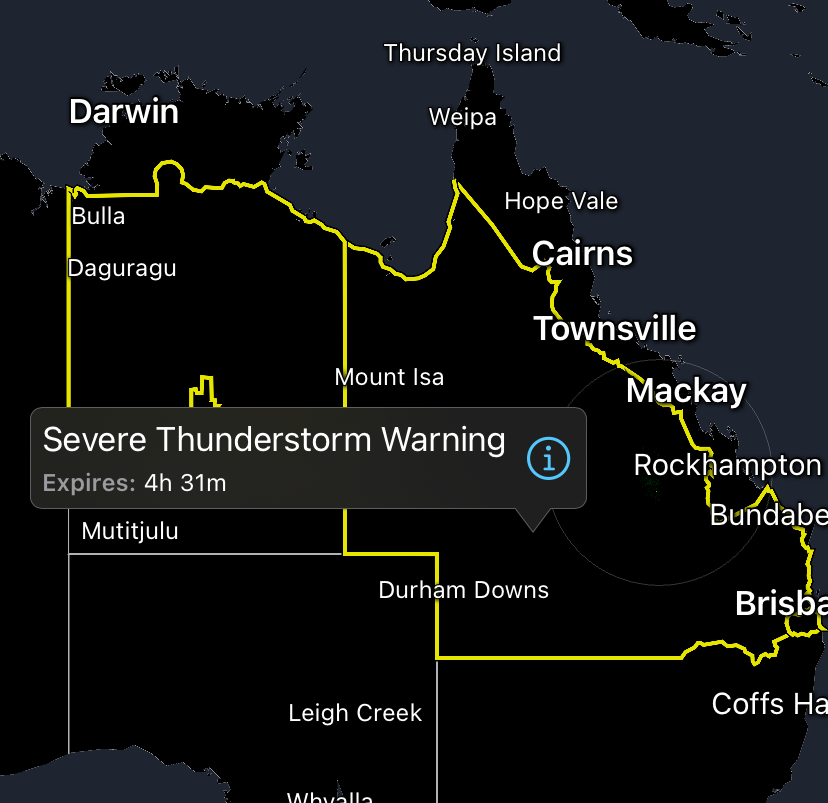
And I thought Canada’s severe thunderstorm warnings were unreasonably large. These ones in Australia are bigger than most American states.
🤮🤮🤮 Worst weather for Christmas


Christmas torch? More like a Christmas sauna? Bonfire? Volcanic eruption? It’s gonna be a hot and sweaty one for many of us.

It looks as though the🔥Heat Miser🔥has taken over the latest outlook for Christmas week (Dec 23-29)! We are looking at a high probability of warmer-than-normal temperatures for the vast majority of the U.S., with the Plains and South likely trading the Snowman for a Sunburn!…

Gross. Should be about 20 degrees cooler on average this time of year x.com/tropicalupdate…

Tracking Christmas Day temps. Little trend down again today on the latest GFS/EURO. Little that is. Some 80's still likely to sneak in for parts of Florida. 70's push way north likely. Ho Ho Ho! spaghettimodels.com

A whole carp in the bath tub is wild 😭😆

rare childhood christmas memory: not being able to take a bath because theres a carp in the bathtub

I’m sorry but this whole plotline trying to attack iCyclone is just wildly delusional. Please find something better to criticize people over because clutching pearls over giving money to hurricane recovery in Jamaica isn’t really the own you think it is.

Josh Morgerman is the supervillan/final boss of the weather community. I hope y'all see that one day! 😤 This isn't a joke, sarcasm, parody, or satire!
This is why TV meteorologists don’t wear green 😅🤣 But it creates a ghostly invisible effect for Halloween


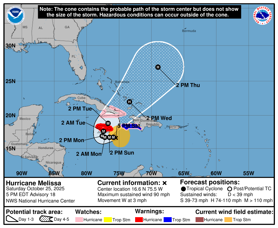
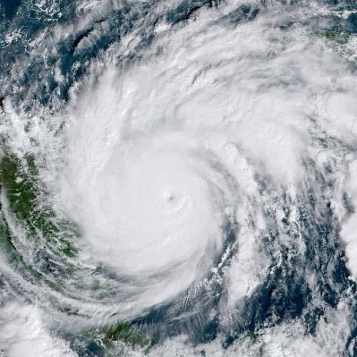
Looks like the Black River area is going to soon feel the brunt of a 185 mph hurricane landfall. Probably some massive storm surge pushing into that bay currently. Hopefully everyone there has evacuated or is in a safe shelter

Geez even more strengthening right before landfall


Fifth and final pass through Hurricane Melissa for our crew today. Just after noon entering from the NW corner exiting SE.


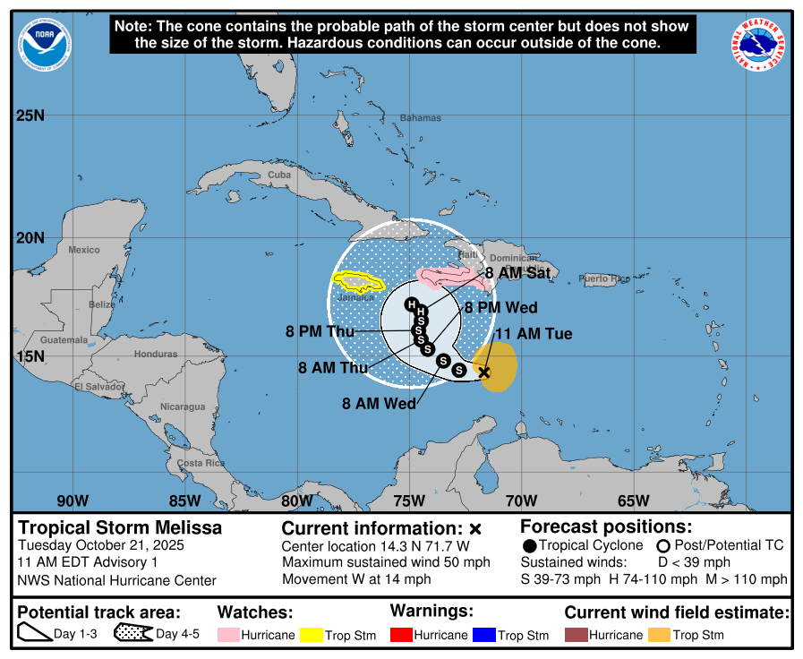
Melissa seems to be going though RI currently. Last couple updates she has gone from 70 MPH to 90 MPH. Currently expected to peak out as a Cat 5 south of Jamaica.
World series?
10 vote · Final results
Jamaica now expecting a head-on hit from a category 4 hurricane early next week. Would likely put Kingston in the front right quadrant where the wind and storm surge will be worst.
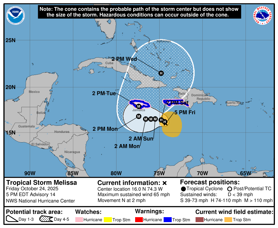
Tropical Storm Melissa very slow moving and expected to increase to major hurricane status. Heavy rainfall will be major threat over next few days.
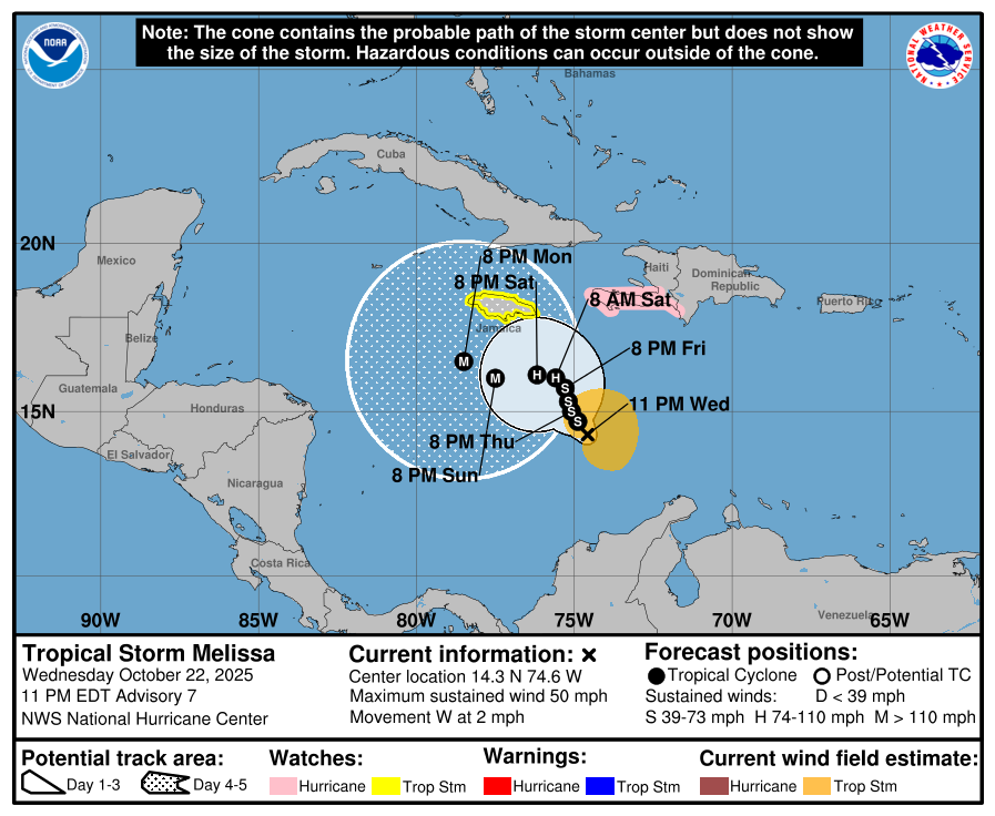
Took until the last handful of weeks of the hurricane season but we got a storm that formed in the Caribbean Sea. Melissa expected to be a very slow mover and could impact Haiti and Jamaica this weekend.

Ok but this was actually really f*ing incredible

.@DevinLloyd_ GOES 99 YARDS TO THE CRIIIIB! Our longest pick six in franchise history! 🏠 #KCvsJAX on ESPN

BREAKING: The EF-5 drought is officially over. The National Weather Service has upgraded the June 20, 2025 Enderlin, North Dakota tornado to EF-5, the first confirmed since 2013’s Moore, OK event. Wind speeds exceeded 210 mph, tossing loaded grain hoppers and even a tanker car…


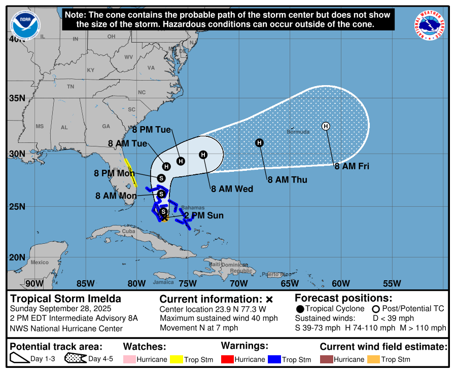
TD 9 has become TS Imelda. She is expected to stay offshore of the US now. Bahamas & Bermuda will likely see more impacts, though.


United States Trends
- 1. CJ Stroud N/A
- 2. Texans N/A
- 3. Texans N/A
- 4. Davis Mills N/A
- 5. Diggs N/A
- 6. #HOUvsNE N/A
- 7. Senegal N/A
- 8. Drake Maye N/A
- 9. #AFCON2025 N/A
- 10. Morocco N/A
- 11. Marcus Jones N/A
- 12. Brahim Diaz N/A
- 13. Woody Marks N/A
- 14. #HTownMade N/A
- 15. Christian Kirk N/A
- 16. Don Lemon N/A
- 17. Schultz N/A
- 18. New England N/A
- 19. 4 INTs N/A
- 20. #NFLPlayoffs N/A
You might like
-
 Chloe Herring
@cherring_VWX -
 Henry Burton
@HenryWX -
 NorthernWisconsinWX
@xtremewxzy -
 Nathan Renner
@Nathan_Renner_ -
 Malik M
@mcdougal_wx -
 Dalton Fickle
@FickleWX -
 Jason ⚡️
@RealJasonWX -
 Alexis Swanson
@aswansonweather -
 Hannah Cavender🌪
@HannahC_WX -
 ℂ𝕙𝕝𝕠𝕖
ℂ𝕙𝕝𝕠𝕖
@wx_chloe4 -
 Victor George
@TotallyWx -
 McCallum_wx
@WeatherToday2 -
 FernWx
@Wx_Fern -
 Jake
Jake
@WX_SouthernIL -
 Bryce Bruggeman
@bruggeman_bryce
Something went wrong.
Something went wrong.