WxByte
@WxByte
User-friendly, beautiful apps for weather data visualization. SatSquatch (GOES satellite & weather data viewer): https://satsquatch.wxbyte.com/
You might like


SatSquatch 2.0 is now live on both Android and iOS! The app itself is now free, as are all satellite layers. try it out and let us know what you think! Android: play.google.com/store/apps/det… iOS: apps.apple.com/us/app/satsqua…
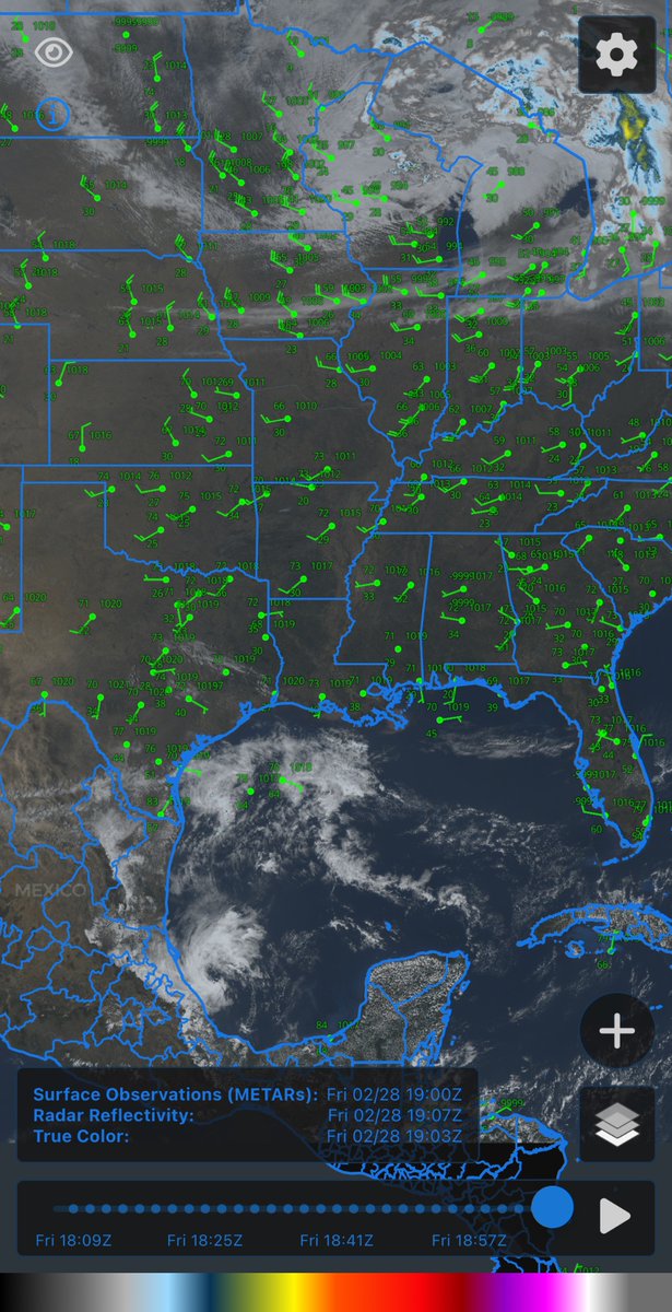
We just released SatSquatch version 2.2.5 which includes a bunch of quality of life updates. This includes map layers being saved between sessions, the ability to keep city & place labels on top, bug fixes, and more! ios: apps.apple.com/us/app/satsqua… android: play.google.com/store/apps/det…
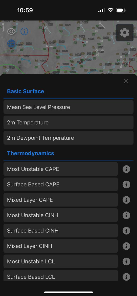
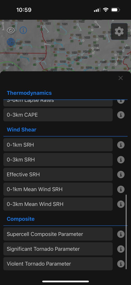
Version 2.2.0 of SatSquatch has been released! This update brings the following changes: - User login for syncing subscription and user data between platforms - MRMS gridded lightning - Opacity slider for overlays - Some small UI improvements - Misc. bug fixes
We just released the new WxByte website, along with a new web version of SatSquatch! Subscriptions are currently limited to the platform you purchase them on, but we are working on an update to allow you to link them. wxbyte.com satsquatch.wxbyte.com

As of earlier today, all SatSquatch GOES-East products have been updated to use data from the newly operational GOES-19 satellite!
I (personally) wish we had been able to provide a lot more context and explain things more fully than through what we thought was an internal presentation. But that doesn’t mean anyone sharing did anything wrong. Now back to my regularly scheduled lurking. :) 13/13
As for those who have apologized for sharing this information today, don’t worry about it. I would have done the same or similar things if I had seen something shared on NOAA social media channels. SPC is not trying to be secretive about any of this. 12/
SPC will always work to improve the quality and sophistication of the information we provide to the weather enterprise. It does not mean that all of it will reach the public in similar form or function. 11/
We still have work to do on how, and to whom, we *communicate* that information. This is why we are still year or more away from implementing something. 10/
What has been discussed today are ways we are internally working on those predictions. The presentation was designed to let science officers in the NWS know what we are working on and to begin soliciting internal feedback on the meteorology aspects of these predictions. 9/
SPC is working on ways to predict days where the coverage of severe storms may be low (Slight) but the intensity of the storms that develop may be greater than what would normally be expected. 8/
The truth is that *most* people, most of the time in a Slight Risk will not observe a severe thunderstorm. However, that does not mean for those who *do* experience them it won’t be bad. 7/
However, the need for this type of information is there. I regularly hear meteorologists complain about the term “Slight Risk”. The complaint is usually along the line of “People can die in Slight Risks”. 6/
Which is why we have not made changes to our public products or even begun the process to do so. We do not know what, if any, of this stuff will look like in final form or public consumption form. 5/
What I have seen shown was our current, internal methods of displaying this kind of information and some potential implications this new intensity information might have on our categories. However, what the final forms of those things will be is far from decided. 4/
It is true that SPC is working on new ways to communicate the potential meteorological intensity of severe thunderstorms. I have discussed this publicly numerous times, including at NWA Annual Meeting in 2023 and on WeatherBrains. 3/
They thought it was public because it was shared publicly on NOAA Social Media (or at least that is what I have heard). Needless to say, easy to see why they thought it was public! The truth is that the information was not intended to be shared publicly. 2/
The following should not be construed as anything close to resembling an official statement … I have seen some posts from people apologizing for sharing what they thought was public information about future enhancements to SPC Forecasts 1/


United States Trends
- 1. FINALLY DID IT N/A
- 2. The Jupiter N/A
- 3. Scott Adams N/A
- 4. The Jito N/A
- 5. Arlington N/A
- 6. #BTSComeback2026 N/A
- 7. #BTSTour2026 N/A
- 8. Dilbert N/A
- 9. HELP IS ON ITS WAY N/A
- 10. #gachiakuta161 N/A
- 11. BTS WORLD TOUR IS COMING N/A
- 12. BTS COMEBACK IS COMING N/A
- 13. Tomlin N/A
- 14. METLIFE N/A
- 15. El Paso N/A
- 16. #csm226 N/A
- 17. Good Tuesday N/A
- 18. #IranMassacre N/A
- 19. Weverse N/A
- 20. Tony Stewart N/A
You might like
-
 Pivotal Weather
@PivotalWeather -
 NEXLAB
@CODMeteorology -
 Helicity - The Weather Super Store!
@Helicity -
 Evan Bentley
@evan_bentley -
 TwisterKidmedia
@TwoDogsWx -
 Bill Line
@bill_line -
 Sam Brandt
@sambrandt99 -
 Gabe Garfield
@WxGabe -
 Jerry Doremus
@Jerry_Doremus -
 Nolan Meister
@Nolan_Meister -
 James Hyde
@wxmeddler -
 madelynn brook⚡️
@madelynn_wx -
 Roger Edwards
@SkyPixWeather -
 Jared Guyer
@JaredGuyer -
 Doppler on Wheels (DOW)
@DOWFacility
Something went wrong.
Something went wrong.