


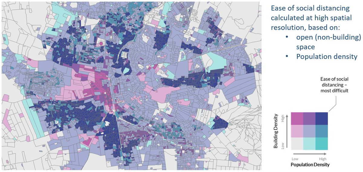
New open building and population density datasets, together with ease of social distancing metrics - now available to download for 50 countries across sub-Saharan Africa: wopr.worldpop.org. Produced as part of @grid3global.
IHGIS (International Historical Geographic Information System) provides data from population and housing censuses, as well as agricultural censuses from around the world ihgis.ipums.org
GeoData@Wisconsin provides access to Wisconsin geospatial data, imagery, and scanned maps. It is developed and maintained by the UW-Madison Geography Department's Robinson Map Library and State Cartographer's Office. geodata.wisc.edu
Protomaps has data extracts from OpenStreetMap, updated every minute. protomaps.com/extracts/
Looking for GDD (growing degree days) data for the United States? usanpn.org/data/maps
PaleoDEM data shows the changing distribution of deep oceans, shallow seas, lowlands, and mountainous regions during the last 540 million years at five million year intervals. earthbyte.org/paleodem-resou…
GRACE Tellus has datasets derived from satellite measurements of gravity field changes, including land water storage and ocean bottom pressure. grace.jpl.nasa.gov/data/get-data/
Over 4 million placenames extracted from Wikipedia github.com/FirstDraftGIS/…
Thenmap is a repository for historical, current and future borders. thenmap.net
SoilGrids.org has global gridded soil properties and classes at 1km and 250m resolution.
Bhutan Geospatial Portal is a rich source of GIS data for Bhutan geo.gov.bt
POLARIS, a 30-meter probabilistic soil series map of the contiguous United States geolode.org/id/5190
Hurricane Harvey Response datasets …arvey-geoplatform.opendata.arcgis.com
ArcticDEM, high-resolution elevation data north of 60 degrees latitude pgc.umn.edu/arcticdem
High Resolution Settlement Layer 30m population density data for Ghana, Haiti, Sri Lanka, Malawi, South Africa ciesin.columbia.edu/data/hrsl/

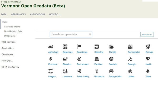
@VCGI is pleased to release a BETA version of Vermont’s new Open Geodata Portal: geodata.vermont.gov
Many thanks to Baruch College for their assistance in editing Geolode.org !
Quantarctica: a collection of Antarctica geography, glaciology, and geophysics data. quantarctica.npolar.no/downloads/


United States เทรนด์
- 1. Thanksgiving 1.71M posts
- 2. Chiefs 92.9K posts
- 3. Chiefs 92.9K posts
- 4. Lamar 20.7K posts
- 5. Ravens 27.6K posts
- 6. Mahomes 29.2K posts
- 7. Zac Taylor 1,610 posts
- 8. Pickens 29.1K posts
- 9. Sarah Beckstrom 142K posts
- 10. #AEWCollision 7,057 posts
- 11. Joe Burrow 9,154 posts
- 12. Tinsley N/A
- 13. Derrick Henry 2,558 posts
- 14. McDuffie 6,979 posts
- 15. Isaiah Likely N/A
- 16. Chase Brown 1,931 posts
- 17. Jason Garrett N/A
- 18. Zay Flowers N/A
- 19. Post Malone 5,086 posts
- 20. Romo 8,613 posts


Something went wrong.
Something went wrong.