
Rodney Barney
@rcbstormpost
Meteorologist at @ECCCWeatherNL | Tweeting tidbits of #NLwx | Views my own
คุณอาจชื่นชอบ


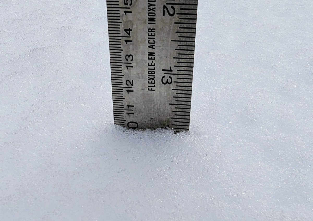
Total snowfall 10.2 cm through 12:30 pm in #GanderWest. Core sample weighing in at 111 grams in 4" @CoCoRaHSCanada gauge, equating to 14 mm water equivalent. Makes for 7:1 snow:liquid ratio. Just a few lingering flurries left in the air as slow melt begins. #nlwx


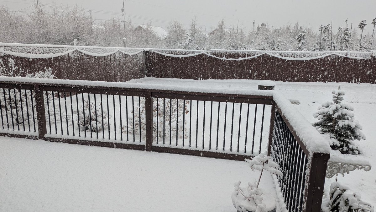
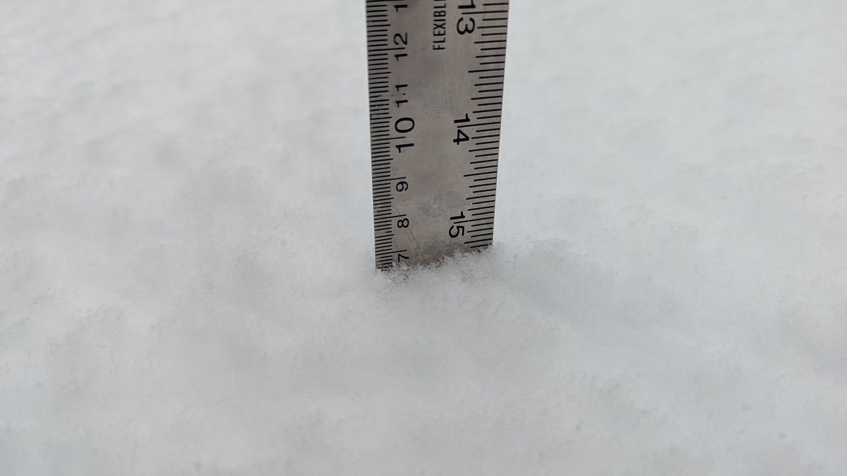
Winter teaser on the way for #Gander tomorrow morning. ❄️ Several hours of pasty wet snow for areas just inland from south coast to the northeast coast (5-10'ish cm, with the higher elevations favoured for the top end). Some afternoon melt likely as temps rise to near 2°C. #nlwx

Pool's I. dropped to 0.0°C right at the end of the Nov 20 climo day, making that its new latest first-freeze date (and bottomed out at -0.4°C this morning). Now 5 sites left to yet reach 0.0°C. Meanwhile low -8.1°C at #Badger this a.m. marks lowest temp since April 11. #nlwx
Still 6 official #NLwx stations that haven't reached 0.0°C or colder this fall as of Nov 20. For Pool's I, Marticot I, & Twillingate, the prev latest date for first-freeze has been surpassed. Will keep watching Sagona I, Grates Cove, & Argentia, where December holds the records.
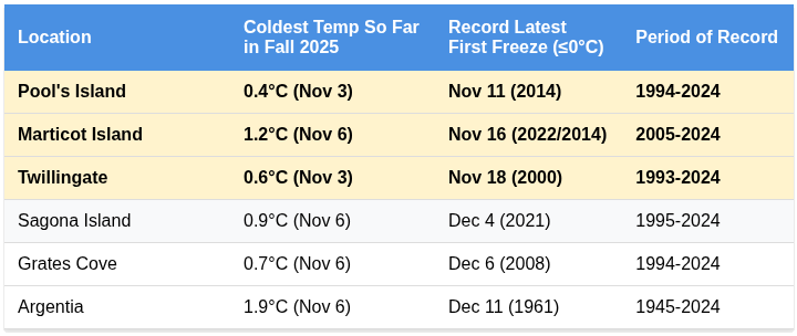
Still 6 official #NLwx stations that haven't reached 0.0°C or colder this fall as of Nov 20. For Pool's I, Marticot I, & Twillingate, the prev latest date for first-freeze has been surpassed. Will keep watching Sagona I, Grates Cove, & Argentia, where December holds the records.
Snow has been building up in the Chateau Pond area of southeastern Labrador since early this morning. Appears rather wet and heavy, likely to change to rain this afternoon. gov.nl.ca/ti/roads/camer… #nlwx
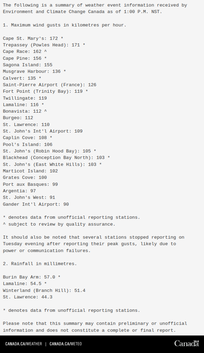
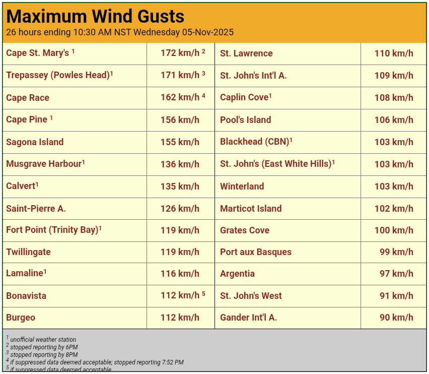
Latest #NLwx system brought gusts in the 100s to a few places last night/early this morning. Winds trending downward now for most.

Top gusts last night: 126 km/h (Powels Head, Trepassey); 111 km/h (Cape Bonavista); 109 km/h (Bonavista); 104 km/h (Grates Cove); 101 km/h (Cape Pine); 100 km/h (Pool's Island); 97 km/h (Blackhead, CBN); 90 km/h (Fogo Island); 85 km/h (St. John's #YYT). #nlwx

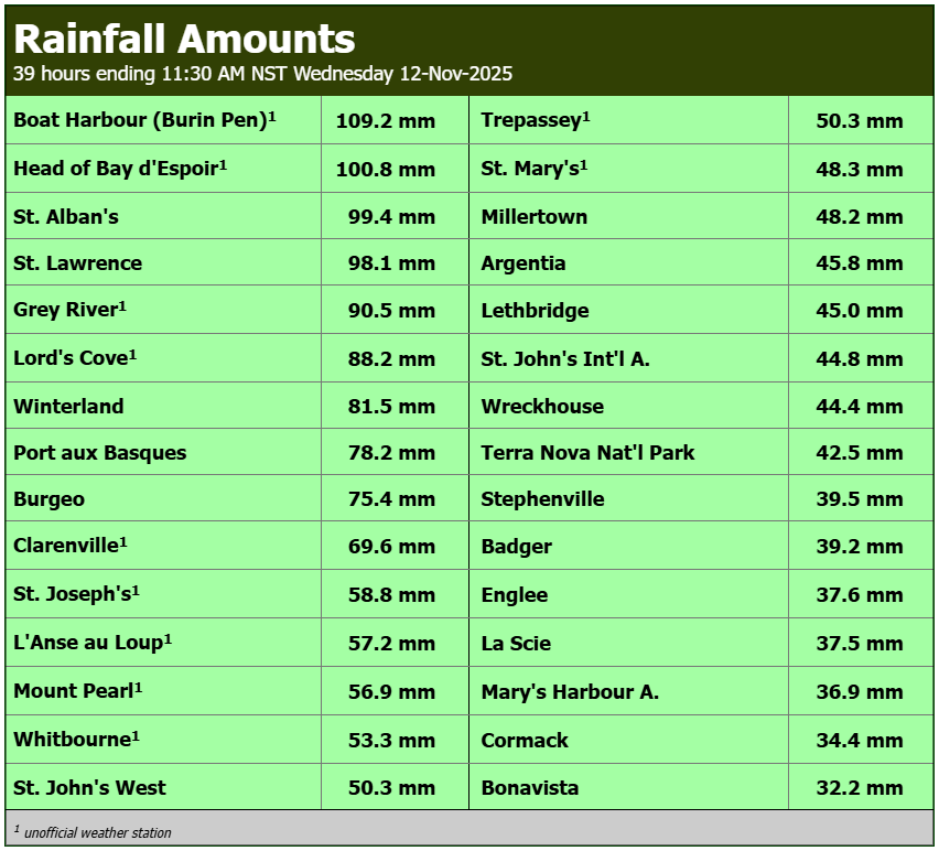
🌧️💨 Rain and wind ruled the day on Remembrance Day across the island and SE Labrador, with gusts still going strong into this morning for some areas. A few lingering showers remain, but precipitation has eased for the most part. #nlwx

Total snowfall 32 cm since midday Monday at Wabush #YWK. Temperature now just above freezing for first time since Thursday; mild conditions will be short-lived, however, as cold air quickly returns this evening. gov.nl.ca/ti/roads/camer… #nlwx

Peak hourly gusts last night thru this morning ≥100 km/h at #Wreckhouse for 16 hrs straight (top gust 120 km/h at 1:19 am). Other peaks: 145 km/h St. Andrew's and 107 km/h Lark Harbour. Bit of lull this afternoon; another round possible tonight (depends on track of low). #nlwx

Not my video! Shared from a friend. #nlwx #wreckhouse #nltraffic #newfoundland travel not recommended for big trucks and here’s why.
❄️ Wintry Monday in western Labrador; snow began around noon and already 9 cm reported as of 4pm at Wabush #YWK. More on the way. 🌡️ Prior to the snow, the temperature bottomed out at -17.6 °C this morning, the coldest minimum since April 8. metcam.navcanada.ca/hb/player.jsp?… #nlwx

Final total last night reported as 9.0 cm at St. John's #YYT, for the first snowfall of the 2025-26 season. A very much elevation-dependent snowfall, with no accum downtown or in CBS. #nlwx
St. John's Airport #YYT reporting 2cm of snow as of 9:30pm. Congratulations to @17kmo (closest pick of November 7) who wins this year's edition of #YYTFirstSnow! docs.google.com/spreadsheets/d… #NLwx
Our summary of this week's 'weather bomb' is now posted at: ow.ly/GcAl50Xni3U #NLwx

Some data here subject to review, but list of currently available numbers shows numerous stations with peak gusts associated with the #NLwx weather bomb reaching well above hurricane force.
St. John's #YYT minimum barometric pressure 950.5 mb this evening marks the lowest value recorded at the location since Feb 11, 2003 (when it reached 949.3 mb). #nlwx
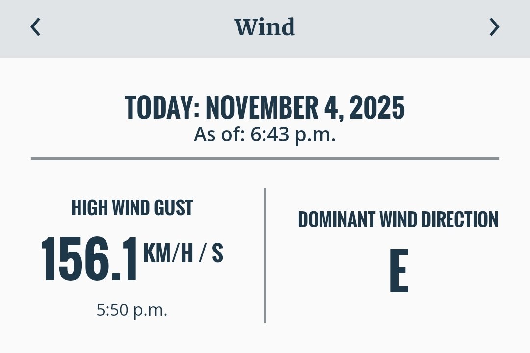
Powles Head Lightstation peak wind gust of 170.6 km/h through 7:50pm. Yikes. Cape Pine Lightstation peak wind gust is 156.1 km/h. #NLwx


United States เทรนด์
- 1. #AskFFT N/A
- 2. #HardRockBet 1,103 posts
- 3. Mason Rudolph 2,135 posts
- 4. Klay 38.8K posts
- 5. Good Sunday 81.7K posts
- 6. Aaron Rodgers 5,064 posts
- 7. Emanuel Wilson N/A
- 8. #sundayvibes 7,197 posts
- 9. Full PPR 1,221 posts
- 10. Raora 3,972 posts
- 11. Josh Jacobs 1,620 posts
- 12. Ja Morant 18.1K posts
- 13. Sean Tucker N/A
- 14. Cornbread 1,832 posts
- 15. #AskBetr N/A
- 16. Great for 60 N/A
- 17. NFL Sunday 6,837 posts
- 18. Tottenham 64.7K posts
- 19. Arsenal 212K posts
- 20. Judkins 1,318 posts
คุณอาจชื่นชอบ
-
 VOCM News
@VOCMNEWS -
 ECCC Weather Newfoundland and Labrador
@ECCCWeatherNL -
 RCMP Newfoundland and Labrador
@RCMPNL -
 NLHydro
@NLHydro -
 Eddie Sheerr
@EddieSheerr -
 Premier of NL
@PremierofNL -
 Transportation and Infrastructure NL
@TI_GovNL -
 YOUR VOCM
@590VOCM -
 Peter Cowan
@PeterCBC -
 Newfoundland Power
@NFPower -
 Michael Connors
@MikeConnors -
 Toni Marie Wiseman 🇨🇦 🍁
@RealToniMarie -
 Gerri Lynn Mackey
@GerriLynnMackey -
 Kelly Butt
@kellymbutt -
 Rosie Mullaley
@Rosie_Mullaley
Something went wrong.
Something went wrong.