
Teledyne Geospatial
@tdygeospatial
The unification of Teledyne’s Optech and CARIS businesses to offer holistic solutions
You might like


Short-term project? Sign up for a CARIS OnDemand account and get access to the software you need in REAL TIME. Pay only for the time you need with low daily rates and licenses delivered to your inbox! teledynecaris.com/en/account/

Our software, your way. Sign up for a CARIS OnDemand account today and access CARIS licenses and training whenever you need them and pay only for the length you need. Available by the day, week, month, or year! Get what you want, and what you need. teledynecaris.com/en/account/

USGS has published #topobathymetric data of the Potomac River acquired by Teledyne Geospatial's CZMIL SuperNova. Congrats to our partner, Dewberry, on a great job!

Use the CARIS OnDemand online store to access CARIS Licenses and purchase online training! Set up an account today at: teledynecaris.com/en/account/ and get licenses and training delivered to your inbox in REAL TIME!

#ICYMI Teledyne Geospatial announced that CARIS software now be available for purchase online. teledynecaris.com/en/news/newsro…

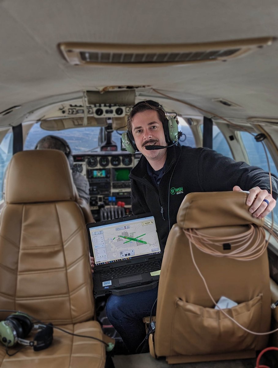
Superior field data is paramount to WGI. But they also found the Galaxy Onboard is easy to pick up, allows the operator to get started with minimal training, with reduced errors and increased productivity. teledyneoptech.com/en/products/ai…
The first U.S. mission to collect an asteroid sample in 2020, delivered the sample to Earth on Sept. 24, 2023. Learn more: science.nasa.gov/mission/osiris…

Don't miss us at Hydro 2023 with our sister company @teledyne-marine We have lots of exciting software developments!
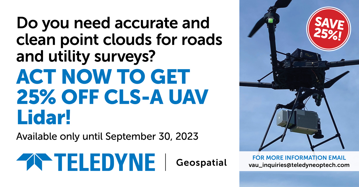
Our CLS-A UAV Lidar offers accurate and clean point clouds for roads and utility surveys. Act now to get 25% off CLS-A UAV Lidar! Order before December 31, 2023 teledyneoptech.com/en/contact/con…

Do you need accurate and clean point clouds for roads and utility surveys? Act now to get 25% off CLS-A UAV Lidar! Order before December 31, 2023 teledyneoptech.com/en/contact/con…

Don't miss us at InterGEO 2023. Visit us at H 27, booth G27.46 where we will showcase our Galaxy Onboard, a unique productivity solution for airborne mapping, capable of delivering real time point cloud and real time quality control reporting tools. teledyneoptech.com/en/news/newsro…

Visit us at InterGEO 2023 in Berlin, Germany, October 10-12. Visit H 27, booth G27.46 and experience the Oceanscience Z-boat 1800 equipped with the Optech CL-360 marine lidar. teledyneoptech.com/en/news/newsro…

Don't miss us at InterGEO 2023 in Berlin, Germany, Oct 10-12. Visit H 27, booth G27.46 to learn about Teledyne’s integration of industry-leading hardware and software workflows. teledyneoptech.com/en/news/newsro…

Don't miss us at Intergeo in Hall: 27 Booth: G27.46 where we will launch our Galaxy Onboard, a unique Productivity Solution for airborne mapping, capable of delivering real-time point cloud and quality control reporting tools. intergeo.de/en/exhibitor-l…

Do you need accurate and clean point clouds for roads and utility surveys? There is still time for you to get 25% off CLS-A survey grade UAV lidar, available only until September 30, 2023! Act now! teledyneoptech.com/en/contact/con…

Still time to sign up for #TeledyneCARIS' 5-day instructor-led online #training course in #HIPSandSIPS from September 25 - 29, 2023; 9:00 am - 4:00 pm (GMT+2). For additional information, or to register: teledynecaris.com/en/support/tra…

Do you need accurate and clean point clouds for roads and utility surveys? There is still time for you to get 25% off CLS-A survey grade UAV lidar, available only until September 30, 2023! teledyneoptech.com/en/contact/con…
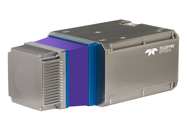
The Teledyne Geospatial CL-360 for marine applications is a LiDAR sensor that can be seamlessly integrated with high-resolution multibeam systems and the CARIS Ping-To-Chart workflow. spatialsource.com.au/marine-lidar-s…
Do you need accurate and clean point clouds for roads and utility surveys? Act NOW to get 25% off CLS-A survey grade UAV lidar, available only until September 30, 2023! teledyneoptech.com/en/contact/con…


United States Trends
- 1. Broncos 30.9K posts
- 2. Treylon Burks 10.7K posts
- 3. Bo Nix 8,168 posts
- 4. Mariota 9,655 posts
- 5. #BaddiesUSA 18.9K posts
- 6. #RaiseHail 4,962 posts
- 7. Commanders 27.5K posts
- 8. Ertz 2,799 posts
- 9. #RHOP 10.3K posts
- 10. #ITWelcomeToDerry 14.6K posts
- 11. Chicharito 24.7K posts
- 12. #Married2Med 2,902 posts
- 13. Tomlin 25K posts
- 14. Bobby Wagner N/A
- 15. Sean Payton 1,209 posts
- 16. Denver 13K posts
- 17. Alex Singleton 1,072 posts
- 18. Zach Edey 2,004 posts
- 19. Riley Moss 2,072 posts
- 20. Steelers 65.1K posts
You might like
-
 Hydro International
@hydro_intl -
 Marine Technology Reporter
@MarineTechno -
 Marine Technology Society
@MTSociety -
 Ocean Robotics Planet (formerly ROV Planet)
@ROVplanet -
 DesertRotor
@DesertRotor -
 Seafloor Systems
@seafloorsystems -
 HYPACK
@HYPACK -
 EdgeTech
@EdgeTechMarine -
 OSIL
OSIL
@Oceanscientific -
 Aquatec
@aquatecgroup
Something went wrong.
Something went wrong.