Onur Tan
@xonurtan
Assoc. Prof. , Seismologist@İTÜ,TÜBİTAK-MRC,İÜC
คุณอาจชื่นชอบ


🆕The 2017 #Lesvos (#Midilli) #earthquake (Mw 6.3): Earthquake hazard implications from source modeling, numerical waveform simulation with regional 1D velocity structure and static stress field. 🆓download until 20 Aug: authors.elsevier.com/c/1lMJo5FJpUaX…

Rahmetli dostum Prof. Dr. Aral Okay ile 1999 yılında yayınladığımız ve ülkemizdeki yerbilimleri yayınları içerisinde en çok atıf alanlardan biri olan Türkiye Tektonik Birlikleri haritası PTT tarafından hatıra pulu olarak basılıyor


"30 Ekim 2020 Ege Denizi-İzmir Depremine (Mw6.9) Yönelik Jeofizik Yaklaşımlar" Jeofizik Mühendisleri Odası (JFMO) İstanbul Şubesi #deprem #izmir @tmmobjfmo @Jfmoistanbul


Introducing SHAppE: the Seismic Hazard Parameters Evaluation toolbox — a #MATLAB App for interactive, time-dependent #SeismicHazard analysis! Try it:👉 GitHub: lnkd.in/eXMGwzNd File Exchange: mathworks.com/matlabcentral/… 💬 Feedback welcome! #Seismology #Earthquake #Geophysics

Bugünkü deprem 5 değil de 7 büyüklüğünde olsaydı, şimdi nerede ve ne yapıyor olacaktınız? Neler için pişmanlık duyup keşke yapsaydım diyecektiniz? Bunları düşünüp gerçekleştirmenin zamanıdır, deprem değil tedbirsizlik öldürüyor

İstanbul içinde ihmal ettiğimiz depremler vardı ... sites.google.com/site/xonurtan/… #istanbul #deprem #earthquake

Another #earthquake beneath #Istanbul city. ❗️❗️

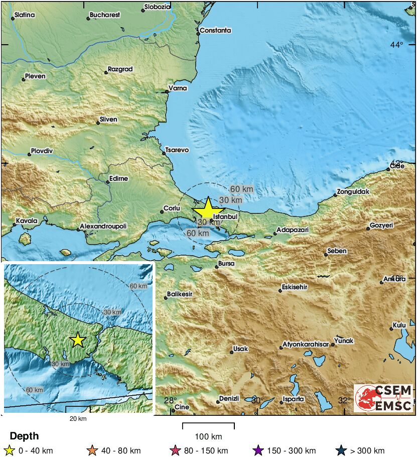
🔔#Earthquake (#deprem) M2.5 occurred 14 km NW of #İstanbul (#Turkey) 10 min ago (local time 13:29:21). More info at: 📱m.emsc.eu/#app 🌐m.emsc.eu/?id=1870587 🖥emsc-csem.org/Earthquake_inf…

Seismic Explorer is a web-based map that allows you to plot earthquakes & volcanic eruptions since 1980, showing subduction zones in 3D & plate motions: seismic-explorer.concord.org


İzmir Bölgesinde Deprem ve Yapı İlişkileri Paneli, 19.08.2025, İnşaat Müh. Odası İzmir Şubesi @imoizmir

Hayatında 1 cm bile fay çizmemiş, diri fay nedir, kinematik nedir bilmeyen; fayın geometrisini, segmentasyonunu tanımayan… Araziye çiçek toplamaya bile gitmemiş insanlar TV’lerde boy gösteriyor. Yazık, çok yazık. #deprem #Sallandık

Çanakkale'de orman yangını | Devlet hastanesi ve yerleşim yerleri tehdit altında; Çanakkale Boğazı kapatıldı! t24.com.tr/haber/canakkal…


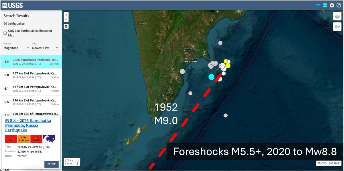
Daha önce kırıldı bir daha kırılmaz diyen #deprem uzmanlarına gelsin. Bu modele göre son #Kamchatka depremi 1952'deki alanı tekrar yırtmış.
Seems that the 2025 event re-ruptured the 1952 area (aftershocks + finite fault). The 2025 didn't rupture across the segment boundary; rather, it nucleated near the possible segment boundary (so did most foreshocks). pku-geophysics-source.group/htmls/20250729…


with friends, Prof. Eleftheria Papadimitriou and Vasileios Karakostas, the 17th Int. Congress of the Geological Society of #Greece, #Mytilene, #Lesvos Island

Mayıs 2012 #Foça #deprem aktivitesi ile aynı yerde (Tan, 2013: drive.google.com/file/d/1ykBIjP… )

#DEPREM FOCA (IZMIR) maps.google.com/maps?q=38.6243… 24.05.2025, 13:51:59 TSİ Büyüklük: 3.6 Derinlik: 15.8 km #Kandilli
Konyada #deprem olmaz diyenler …
#DEPREM KIRKKUYU-KULU (KONYA) maps.google.com/maps?q=39.058,… 15.05.2025, 15:46:36 TSİ Büyüklük: 5.2 Derinlik: 6.9 km #Kandilli


United States เทรนด์
- 1. Howie 4,961 posts
- 2. Good Monday 39.8K posts
- 3. #MondayMotivation 30.8K posts
- 4. Phillips 500K posts
- 5. $IREN 12.3K posts
- 6. Victory Monday 1,541 posts
- 7. #Talus_Labs N/A
- 8. #MondayVibes 2,332 posts
- 9. Winthrop N/A
- 10. 60 Minutes 98.4K posts
- 11. Kimberly-Clark N/A
- 12. $QURE 3,650 posts
- 13. Jets 3rd N/A
- 14. Kenvue 3,777 posts
- 15. #RomanEmpireByBangChan 22.9K posts
- 16. #MondayMood 1,190 posts
- 17. St. Martin de Porres N/A
- 18. $MSFT 17.4K posts
- 19. ROMAN EMPIRE OUT NOW 19.6K posts
- 20. Spinoza 1,530 posts
คุณอาจชื่นชอบ
-
 Jeolog35⛏️
@EgeliJeolog -
 Doç. Dr. Taylan SANÇAR
@tsancar -
 Cengiz Zabcı
@CengizZabci -
 Prof. Dr. Osman Bektaş
@profobektas -
 Okan Tüysüz
@okangeo -
 Eşref Yalçınkaya
@eyalcinka -
 Hasan Elmacı
@arduvaz06 -
 Melihbaki
@Melihba30459853 -
 Candan Gökçeoğlu
@CGokceoglu -
 Prof.Dr. Tuncay Taymaz
@TuncayTaymaz -
 Baturhan Öğüt®️⛏📝
@QuakeResearche -
 Dr. Ramazan Demirtaş
@Paleosismolog -
 ITU Earth3Bee Lab.
@Earth3Bee -
 Aynur Dikbas
@AynurDikbas -
 Dr. Yesim Alpay Biro
@YesimAlpayBiro
Something went wrong.
Something went wrong.