#geosat2 ผลการค้นหา

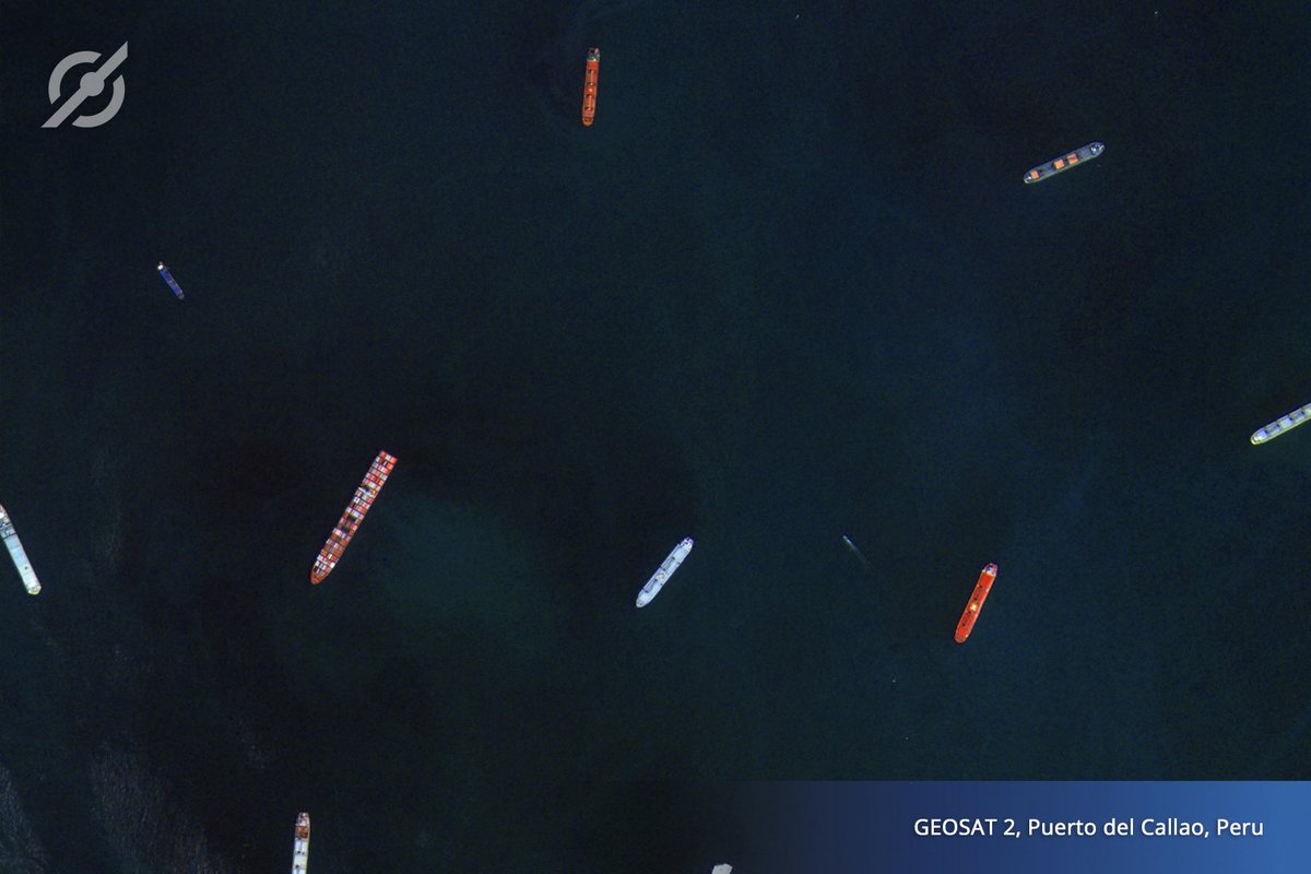
#GEOSAT2 for activity detection, identifying and classifying #vessels… #GEOSATSeries #MARITIME #Shipdetection
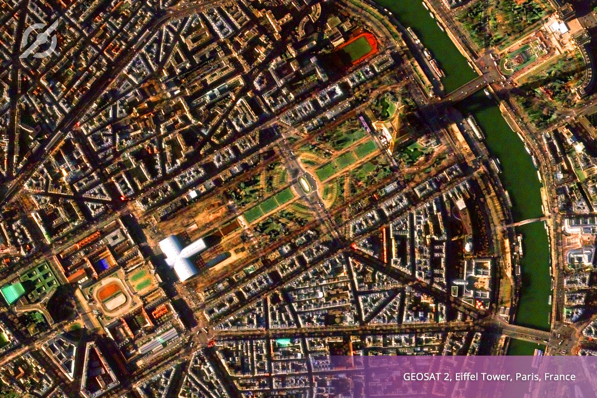
This is how the #EiffelTower looks like from the #GEOSAT2 orbit #GEOSATSeries #LEISURE #SatelliteImagery #Paris #France
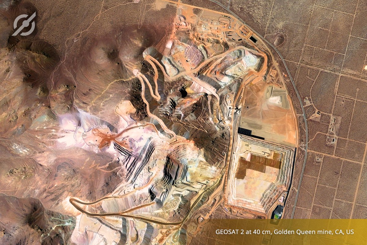
#GEOSATSeries - #ENERGYandRESOURCES - #GEOSAT2 captured this #SuperResolution image over the #GoldenQueenMine; an underground #mining operation located in #Mojave #California #SatelliteImagery #NaturalResources #OpenPitMine
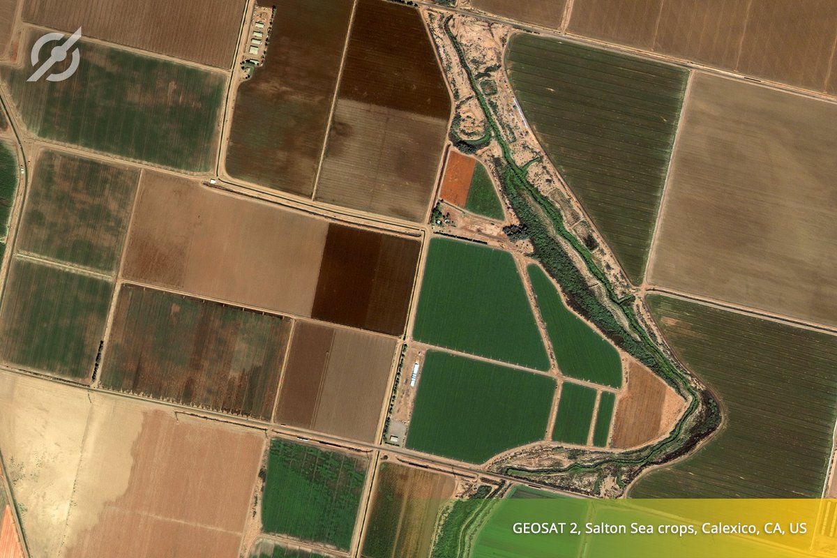
#GEOSATSeries - #AGRICULTURE - Detect changes in your land, monitor productivity and forecast yield levels… #GEOSAT2 #PrecisionAgriculture
Our satellites, #GEOSAT1 & #GEOSAT2 are operated continuously through a 24/7/365 service. Moreover, ground station management ensures contact in each orbit, allowing to command and download data every 90 minutes. #GeosatSeries #DefenseandSecurity #MaritimeSuerveillance
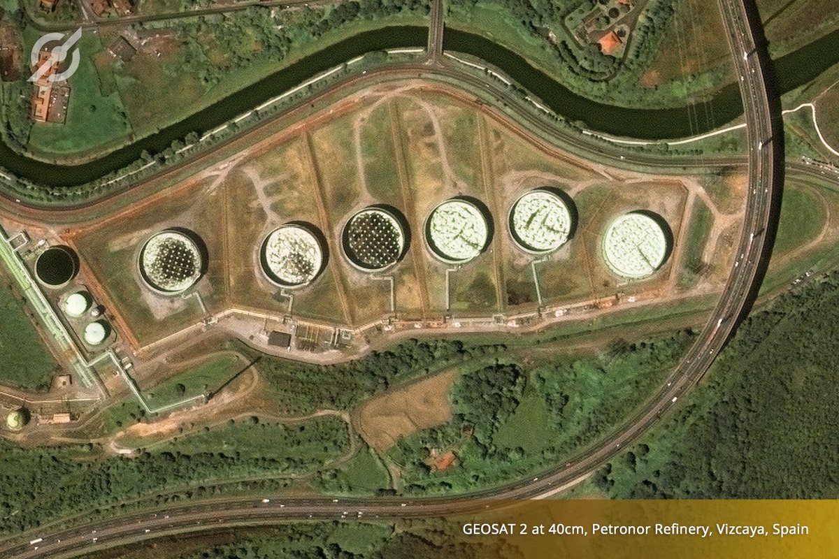
#GEOSAT2 captured this #SuperResolution image of the @Petronor_Info refinery, the first Spanish refinery to produce unleaded gasoline. Monitor your assets with GEOSAT's #SuperResolution products and get accurate information in a short period of time. #ENERGYandRESOURCES
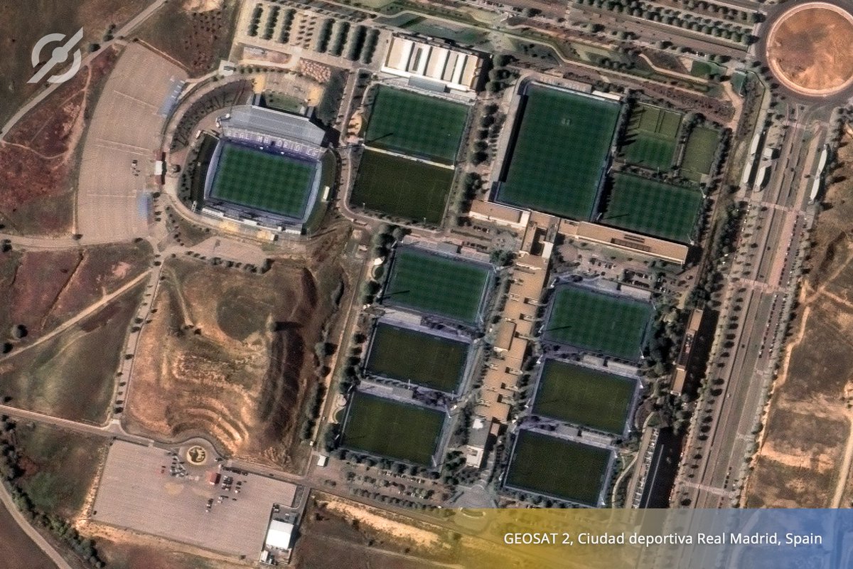
#GEOSATSeries - #LANDandINFRASTRUCTURES – #GEOSAT2 at 0.75m resolution and daily revisit of 2 days, allows the analysis of #CivilEngineering Structures. #StructuralEngineering #ChangeDetection #CiudadDeportivaRealMadrid @realmadrid @realmadriden
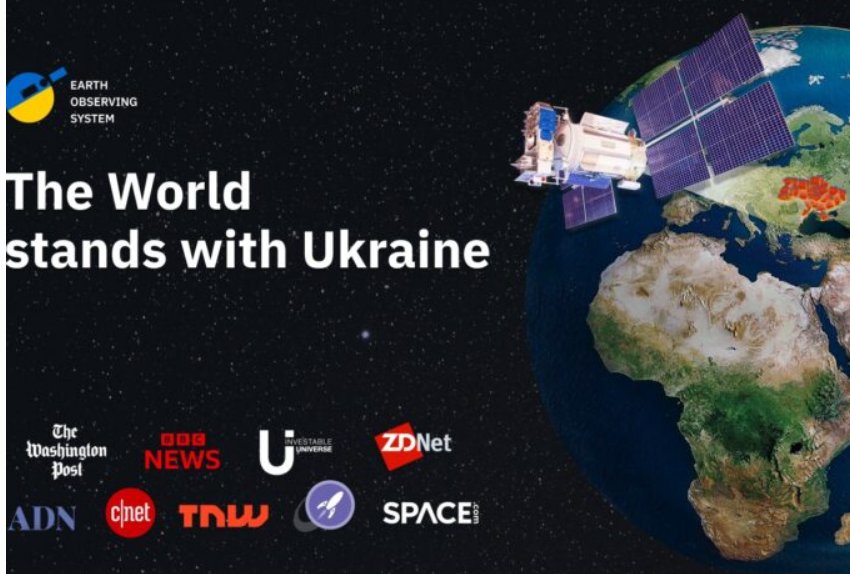
Die #Ukraine erhält von @eos_da Zugang zu Satellitenbildern mit ultrahoher Auflösung „Das heißt, die Ukraine ist faktisch Miteigentümerin eines multispektralen Satelliten geworden, der es ermöglicht, exklusive Satellitendaten von #GEOSAT2 zu empfangen.“ eos.com/stand-with-ukr…
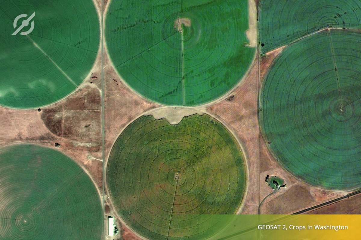
Agricultural structures in #Washington are seen in great detail from the orbit of #GEOSAT2 #DYK that our data is a key source of information to boost productivity? Find out more information here: ow.ly/uTLH50LAYmX #GEOSATSeries #AGRICULTURE #PrecisionAg #SmartAgriculture
Detect unauthorized building work and decide when development activity begins to put people at risk. We're looking forward to creating your bespoke solution! Ready to see how we can help? Just click here 👉 ow.ly/XKui50Lt7U5 #GEOSATSeries #LANDandINFRASTRUCTURES #GEOSAT2

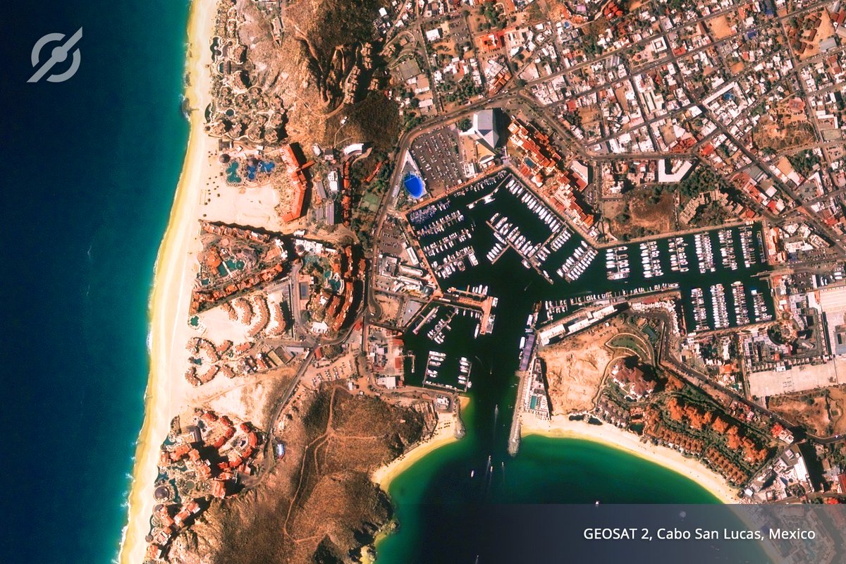
In #May, the #LovePlanetEarth2022 calendar takes us to Mauritania, where the #GEOSAT2 satellite shows us the many fishing boats that populate the bay of #Nouadhibou, an example of artisanal and #sustainable fishing. #IYAFA22
#GEOSATSeries - #DEFENSEandSECURITY - #GEOSAT2 captured images of #BuckinghamPalace last week, where dozens of people came to bid farewell and pay tribute to #QueenElizabethII, the longest reigning sovereign in the history of the #UnitedKingdom. #queensfuneral #CivilProtection
Have a look at these #GEOSAT2 images captured over @esa in #Frascati, and notice the difference obtained by applying our #SuperResolution product at 40 cm. Sharper edges, good calibration, high-quality inputs and more by using #AI More information here 👉 ow.ly/k7XS50LxrYA

Україна отримала доступ до ексклюзивних високоточних супутникових знімків GEOSAT 2 став першим супутнико #GEOSAT2 #супутник #супутниковізнімки sundries.com.ua/?p=34570

Thanks to the agreement reached more than a month ago, #Ukraine has de facto become the owner of a multispectral optical satellite and receives exclusive satellite data from #GEOSAT2. #RussiaUkraineWar universemagazine.com/en/eosda-contr…
Our satellites, #GEOSAT1 & #GEOSAT2 are operated continuously through a 24/7/365 service. Moreover, ground station management ensures contact in each orbit, allowing to command and download data every 90 minutes. #GeosatSeries #DefenseandSecurity #MaritimeSuerveillance
Agricultural structures in #Washington are seen in great detail from the orbit of #GEOSAT2 #DYK that our data is a key source of information to boost productivity? Find out more information here: ow.ly/uTLH50LAYmX #GEOSATSeries #AGRICULTURE #PrecisionAg #SmartAgriculture
Have a look at these #GEOSAT2 images captured over @esa in #Frascati, and notice the difference obtained by applying our #SuperResolution product at 40 cm. Sharper edges, good calibration, high-quality inputs and more by using #AI More information here 👉 ow.ly/k7XS50LxrYA
#GEOSAT2 for activity detection, identifying and classifying #vessels… #GEOSATSeries #MARITIME #Shipdetection
#GEOSAT2 captured this #SuperResolution image of the @Petronor_Info refinery, the first Spanish refinery to produce unleaded gasoline. Monitor your assets with GEOSAT's #SuperResolution products and get accurate information in a short period of time. #ENERGYandRESOURCES
Detect unauthorized building work and decide when development activity begins to put people at risk. We're looking forward to creating your bespoke solution! Ready to see how we can help? Just click here 👉 ow.ly/XKui50Lt7U5 #GEOSATSeries #LANDandINFRASTRUCTURES #GEOSAT2
This is how the #EiffelTower looks like from the #GEOSAT2 orbit #GEOSATSeries #LEISURE #SatelliteImagery #Paris #France
#GEOSATSeries - #AGRICULTURE - Detect changes in your land, monitor productivity and forecast yield levels… #GEOSAT2 #PrecisionAgriculture
#GEOSATSeries - #DEFENSEandSECURITY - #GEOSAT2 captured images of #BuckinghamPalace last week, where dozens of people came to bid farewell and pay tribute to #QueenElizabethII, the longest reigning sovereign in the history of the #UnitedKingdom. #queensfuneral #CivilProtection
#GEOSATSeries - #LANDandINFRASTRUCTURES – #GEOSAT2 at 0.75m resolution and daily revisit of 2 days, allows the analysis of #CivilEngineering Structures. #StructuralEngineering #ChangeDetection #CiudadDeportivaRealMadrid @realmadrid @realmadriden
#GEOSATSeries - #ENERGYandRESOURCES - #GEOSAT2 captured this #SuperResolution image over the #GoldenQueenMine; an underground #mining operation located in #Mojave #California #SatelliteImagery #NaturalResources #OpenPitMine
#GEOSATSeries - #LANDandINFRASTRUCTURES – GEOSAT's unrivalled archive gives you the perfect dataset to analyse development over time in any area in the world. #GEOSAT2 #Valdebebas #Madrid
This is how the #EiffelTower looks like from the #GEOSAT2 orbit #GEOSATSeries #LEISURE #SatelliteImagery #Paris #France
#GEOSAT2 for activity detection, identifying and classifying #vessels… #GEOSATSeries #MARITIME #Shipdetection
#GEOSATSeries - #ENERGYandRESOURCES - #GEOSAT2 captured this #SuperResolution image over the #GoldenQueenMine; an underground #mining operation located in #Mojave #California #SatelliteImagery #NaturalResources #OpenPitMine
#GEOSATSeries - #LANDandINFRASTRUCTURES – #GEOSAT2 at 0.75m resolution and daily revisit of 2 days, allows the analysis of #CivilEngineering Structures. #StructuralEngineering #ChangeDetection #CiudadDeportivaRealMadrid @realmadrid @realmadriden
#GEOSATSeries - #AGRICULTURE - Detect changes in your land, monitor productivity and forecast yield levels… #GEOSAT2 #PrecisionAgriculture
#GEOSAT2 captured this #SuperResolution image of the @Petronor_Info refinery, the first Spanish refinery to produce unleaded gasoline. Monitor your assets with GEOSAT's #SuperResolution products and get accurate information in a short period of time. #ENERGYandRESOURCES
In #May, the #LovePlanetEarth2022 calendar takes us to Mauritania, where the #GEOSAT2 satellite shows us the many fishing boats that populate the bay of #Nouadhibou, an example of artisanal and #sustainable fishing. #IYAFA22
Our satellites, #GEOSAT1 & #GEOSAT2 are operated continuously through a 24/7/365 service. Moreover, ground station management ensures contact in each orbit, allowing to command and download data every 90 minutes. #GeosatSeries #DefenseandSecurity #MaritimeSuerveillance
Die #Ukraine erhält von @eos_da Zugang zu Satellitenbildern mit ultrahoher Auflösung „Das heißt, die Ukraine ist faktisch Miteigentümerin eines multispektralen Satelliten geworden, der es ermöglicht, exklusive Satellitendaten von #GEOSAT2 zu empfangen.“ eos.com/stand-with-ukr…
Agricultural structures in #Washington are seen in great detail from the orbit of #GEOSAT2 #DYK that our data is a key source of information to boost productivity? Find out more information here: ow.ly/uTLH50LAYmX #GEOSATSeries #AGRICULTURE #PrecisionAg #SmartAgriculture
Detect unauthorized building work and decide when development activity begins to put people at risk. We're looking forward to creating your bespoke solution! Ready to see how we can help? Just click here 👉 ow.ly/XKui50Lt7U5 #GEOSATSeries #LANDandINFRASTRUCTURES #GEOSAT2
Something went wrong.
Something went wrong.
United States Trends
- 1. Thanksgiving 1.31M posts
- 2. Thankful 214K posts
- 3. Turkey Day 28.4K posts
- 4. Busta Rhymes N/A
- 5. Lil Jon N/A
- 6. Toys R Us N/A
- 7. Afghanistan 229K posts
- 8. Turn Down for What N/A
- 9. #ProBowlVote 8,646 posts
- 10. Shaggy 3,182 posts
- 11. #Gratitude 6,668 posts
- 12. Mr. Fantasy N/A
- 13. #Grateful 3,938 posts
- 14. Debbie Gibson N/A
- 15. Gobble Gobble 19.3K posts
- 16. Sarah Beckstrom 7,868 posts
- 17. Andrew Wolfe 23.6K posts
- 18. Taylor Momsen N/A
- 19. Feliz Día de Acción de Gracias 2,121 posts
- 20. Conan Gray 1,651 posts