#geo2grid search results

In case you didn't see enough #GOES16/#GOESeast True Color RGB animations of the 15 December sting-jet-enhanced blowing dust event in the Plains, here's a full-resolution version created using @UWSSEC #Geo2Grid: cimss.ssec.wisc.edu/satellite-blog… #NMwx #TXwx #OKwx #COwx #KSwx #NEwx
...and here's a closer look at #GOES16/#GOESeast True Color RGB images centered at Veracruz MMVR (created using @UWSSEC #Geo2Grid), which help to highlight the inland plumes of blowing dust behind the cold front: cimss.ssec.wisc.edu/satellite-blog…
Similar to yesterday, #GOES16/#GOESeast True Color RGB images (created using @UWSSEC #Geo2Grid) revealed pyrocumulus clouds & a large smoke plume produced by the #ChipolaComplex in the Florida Peninsula, which was transported into southwestern Georgia: @NWSTallahassee #FLwx #GAwx
#GOES16/#GOESeast True Color RGB images (created using @UWSSEC #Geo2Grid) showed the smoke-rich #pyrocumulus clouds produced by the #BerthaSwampRoadFire -- which rose above the background cumulus cloud street field that was flowing inland: cimss.ssec.wisc.edu/satellite-blog… #FLwx
True color #stereoscopic imagery of the big storm on 13 March 2019. Created with #geo2grid and #GOES16 and #GOES17 data
#GOES16/#GOESeast True Color RGB images - created using @UWSSEC #Geo2Grid - showed widespread blowing dust (shades of tan) and wildfire smoke plumes (brighter shades of white) across much of the central/southern Plains: cimss.ssec.wisc.edu/satellite-blog… #NMwx #COwx #TXwx #OKwx #KSwx
The hail swath is a little bit easier to see in this version of #GOES16/#GOESeast Day Snow-Fog RGB images (created using @UWSSEC #Geo2Grid): cimss.ssec.wisc.edu/satellite-blog…
The record-setting pace of the 2022 Alaska wildfire season continues, with thick smoke covering most of the northern half of the state - as seen in @NOAASatellites #GOES17/#GOESwest True Color RGB images created using @UWSSEC #Geo2Grid: cimss.ssec.wisc.edu/satellite-blog… @NWSFairbanks #AKwx

The record-setting pace of the 2022 Alaska wildfire season continues, with thick smoke covering most of the northern half of the state yesterday - as seen in @NOAASatellites #GOES17/#GOESwest True Color RGB images created using @UWSSEC #Geo2Grid: cimss.ssec.wisc.edu/satellite-blog…
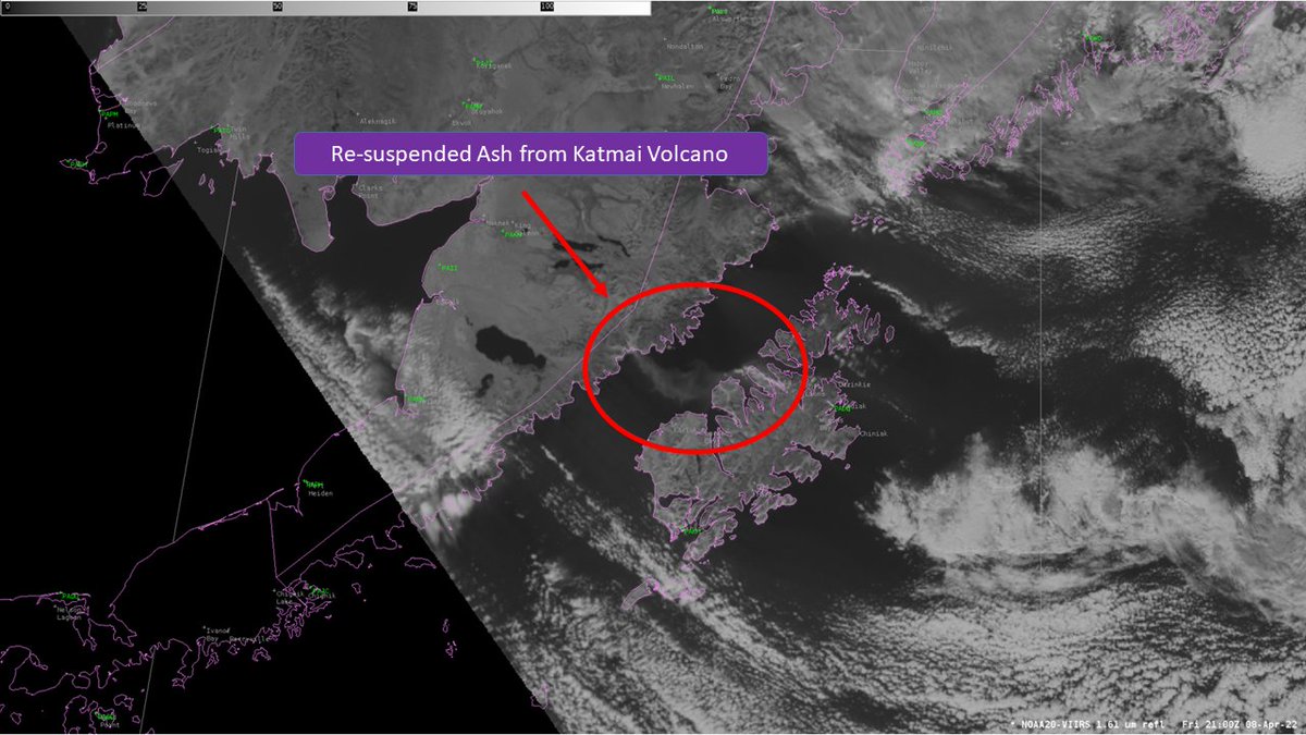
.@NWSAnchorage, here's an animation of 1-minute #GOES17/#GOESwest True Color RGB images (created using @UWSSEC #Geo2Grid) during the daylight hours: cimss.ssec.wisc.edu/satellite-blog… Looks like there was a second, stronger pulse of resuspended #Katmai ash that began around 00 UTC. #AKwx


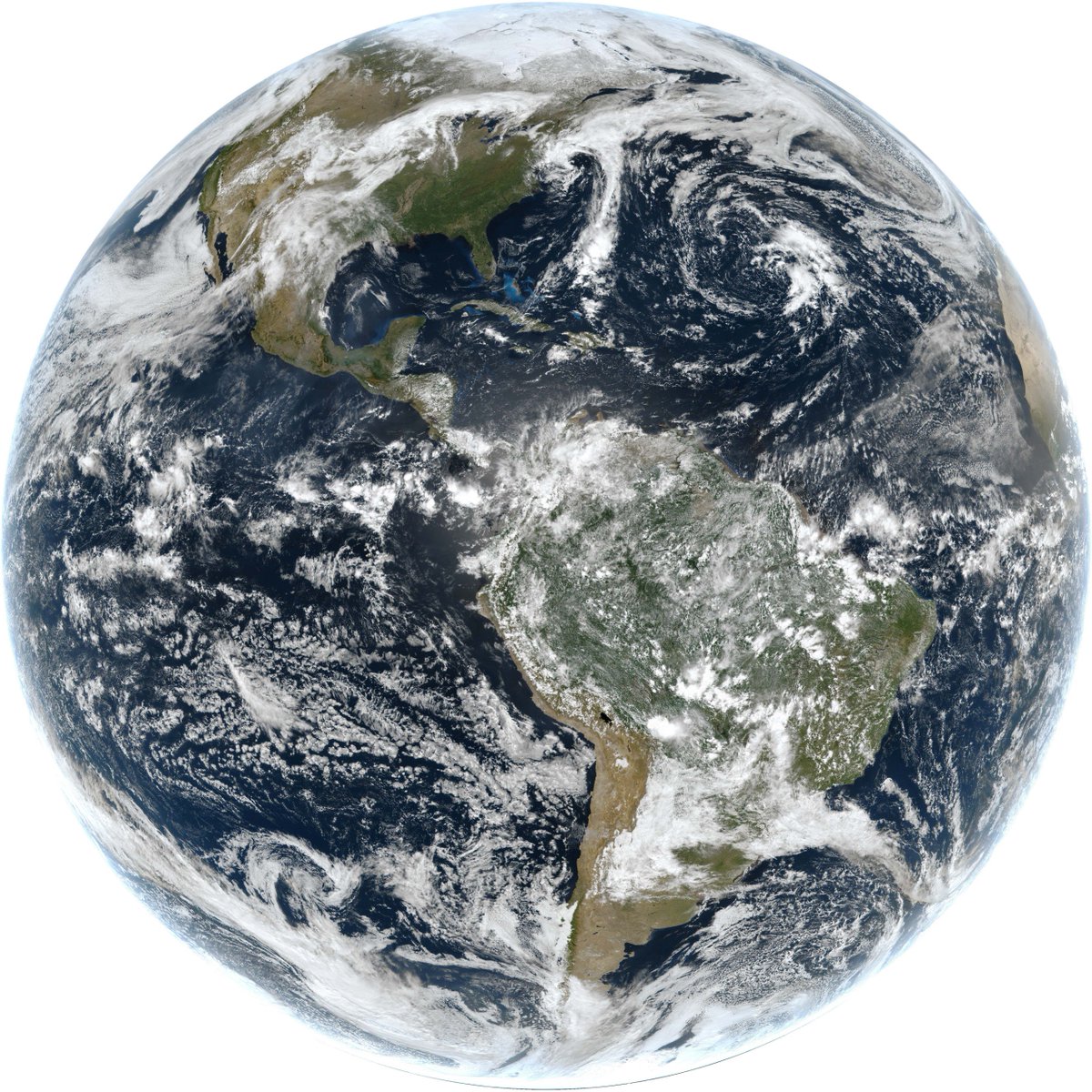
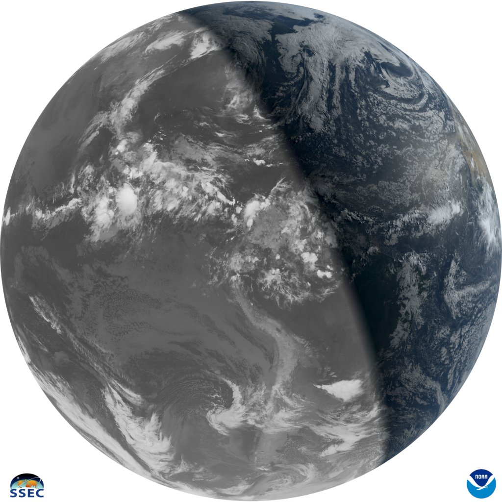
At SSEC we see a lot of full-disk images - and we never get tired of them. Happy #Earthday #geo2grid #PictureEarth #EarthWeek #GOESEast
Way cool, here's another 'false color' @NOAASatellites ABI #GOES16 RGB view: cimss.ssec.wisc.edu/satellite-blog… Snow is red. @UWSSEC #geo2grid

GOES-East Geocolor Imagery from today captures the extent of snowfall, and snowmelt, from yesterday's event over the eastern US.
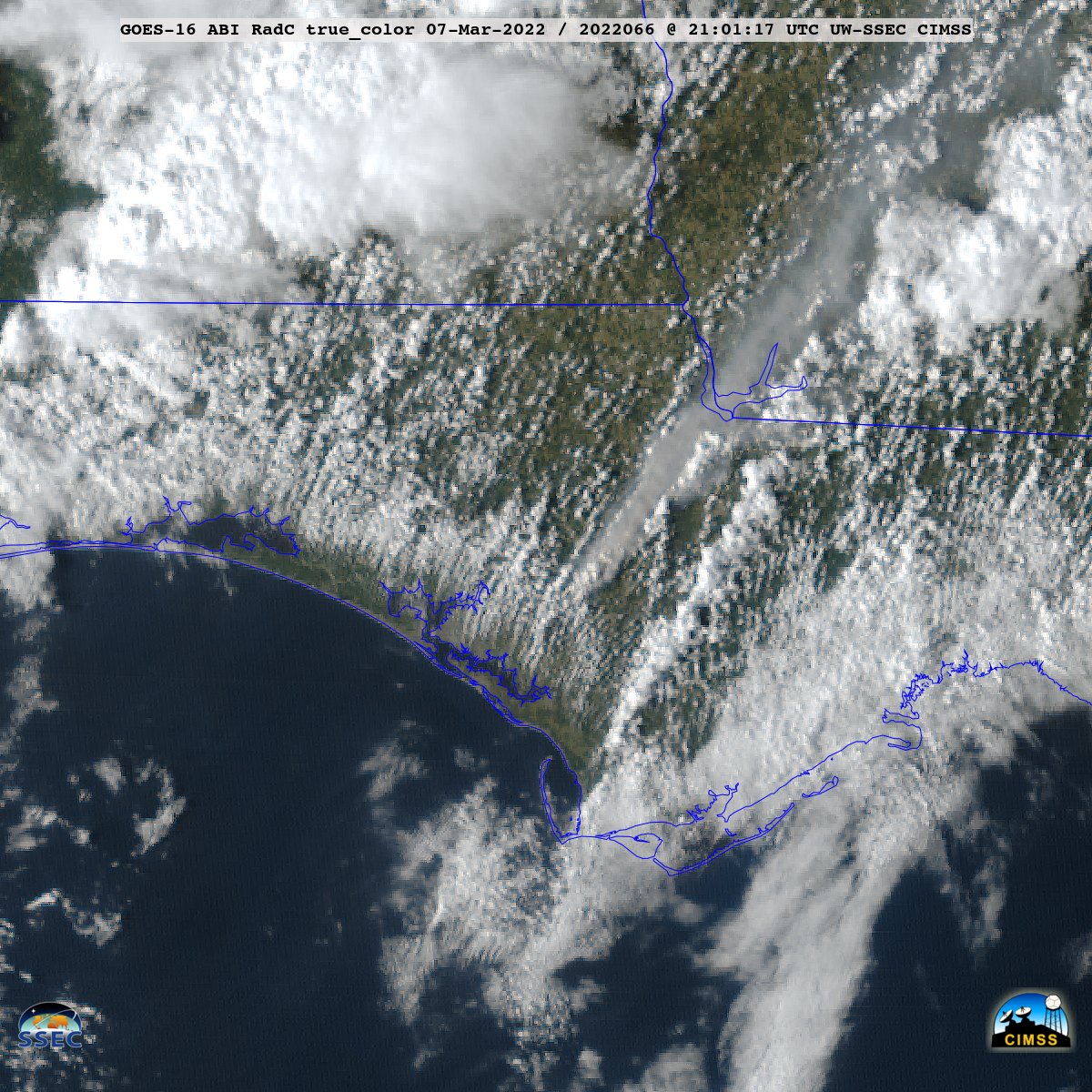
.@NOAASatellites #GOES16/#GOESeast True Color RGB images (created using @UWSSEC #Geo2Grid) showed a brief plume of black smoke, which moved quickly NE -- caused by the collision of 2 semi-trucks just west of I-94 in southeastern WI: cimss.ssec.wisc.edu/satellite-blog… @NWSMilwaukee #WIwx
1-minute @NOAASatellites #GOES16/#GOESeast ABI "rocket plume" RGB images: cimss.ssec.wisc.edu/satellite-blog…. More wrt RGB: cimss.ssec.wisc.edu/goes/OCLOFactS… H/T @CIMSS_Satellite @UWCIMSS #geo2grid @UWSSEC @NWSMelbourne #FLwx [@nws #AWIPS users: a rocket plume RGB is a option under local menus.]
.@NOAASatellites #GOES16/#GOESeast True Color RGB images (created using @UWSSEC #Geo2Grid) showed a brief plume of black smoke, which moved quickly NE -- caused by the collision of 2 semi-trucks just west of I-94 in southeastern WI: cimss.ssec.wisc.edu/satellite-blog… #WIwx
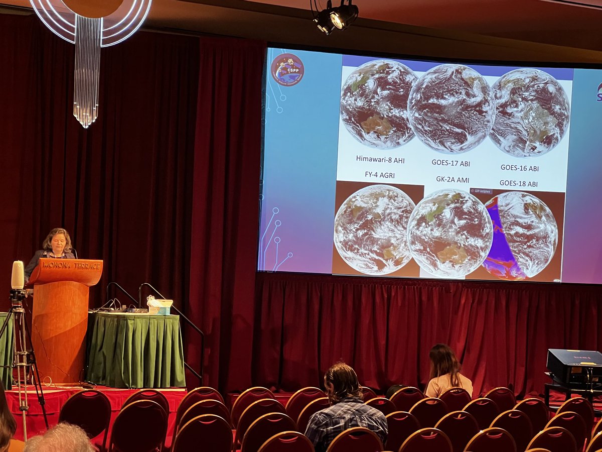
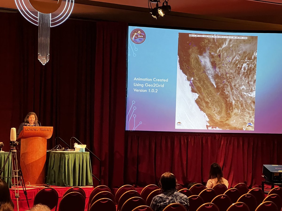
Advancements in #Polar2Grid and #Geo2Grid Image Creation Software @ametsoc #ams2022cmm @UWSSEC check it out: cimss.ssec.wisc.edu/csppgeo/geo2gr… @CIMSS_Satellite
Or, there's the preliminary, non-operational @NOAASatellites #GOES18 ABI "SO2" RGB: cimss.ssec.wisc.edu/satellite-blog… HT @UWSSEC @UWCIMSS #geo2grid @WxSatChat @CIMSS_Satellite
Distinct SO2 signature from the #MaunaLoaVolcano eruption in both the @NOAASatellites #GOES17/#GOESwest SO2 RGB and Ash RGB images: cimss.ssec.wisc.edu/satellite-blog… More from @WxSatChat: cimss.ssec.wisc.edu/satellite-blog… #HIwx
Another #GOEST plume view from @NOAASatellites #GOES17 meso-scale: cimss.ssec.wisc.edu/satellite-blog… H/T @weatherdak @UWSSEC #geo2grid
Super excited about the countdown to the launch of @NOAASatellites #GOEST! ABI images/RGB composites from last summer: cimss.ssec.wisc.edu/satellite-blog… More: goes-r.gov/users/transiti… cimss.ssec.wisc.edu/goes/goesdata.… star.nesdis.noaa.gov/GOES/index.php #ReadySetGOEST@UWCIMSS @UWSSEC #geo2grid #GOESWest
Volcano #Popocatépetl as seen by a preliminary, non-operational @NOAASatellites #GOES19 ABI cimss.ssec.wisc.edu/satellite-blog… week long ash RGB loop (rammb.cira.colostate.edu/training/visit…). #geo2grid @UWSSEC @UWCIMSS More: volcano.ssec.wisc.edu/imagery/view/#… or ospo.noaa.gov/products/atmos…
Select @NOAASatellites #GOES19 (preliminary, non-operational) ABI animations added to this @UWCIMSS Satellite Blog: cimss.ssec.wisc.edu/satellite-blog… cimss.ssec.wisc.edu/satellite-blog… For example: Fire_GOES-19_RadM1_cimss_true_color_2024311_170224_2024312_003724Z.mp4 #geo2grid @UWSSEC
Volcano #Popocatépetl as seen by a preliminary, non-operational @NOAASatellites #GOES19 ABI cimss.ssec.wisc.edu/satellite-blog… week long ash RGB loop (rammb.cira.colostate.edu/training/visit…). #geo2grid @UWSSEC @UWCIMSS More: volcano.ssec.wisc.edu/imagery/view/#… or ospo.noaa.gov/products/atmos…
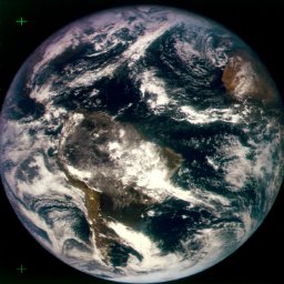
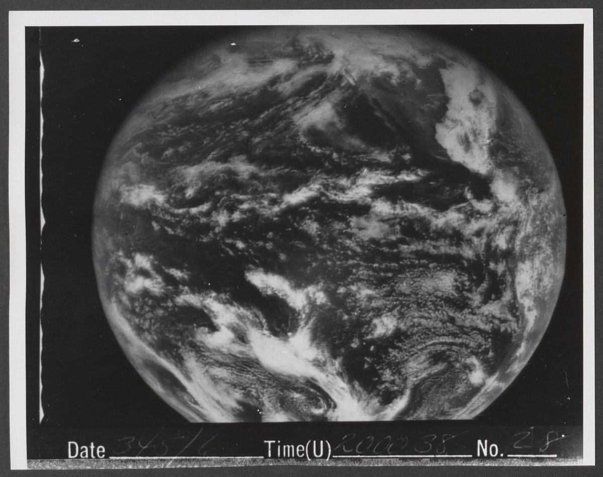
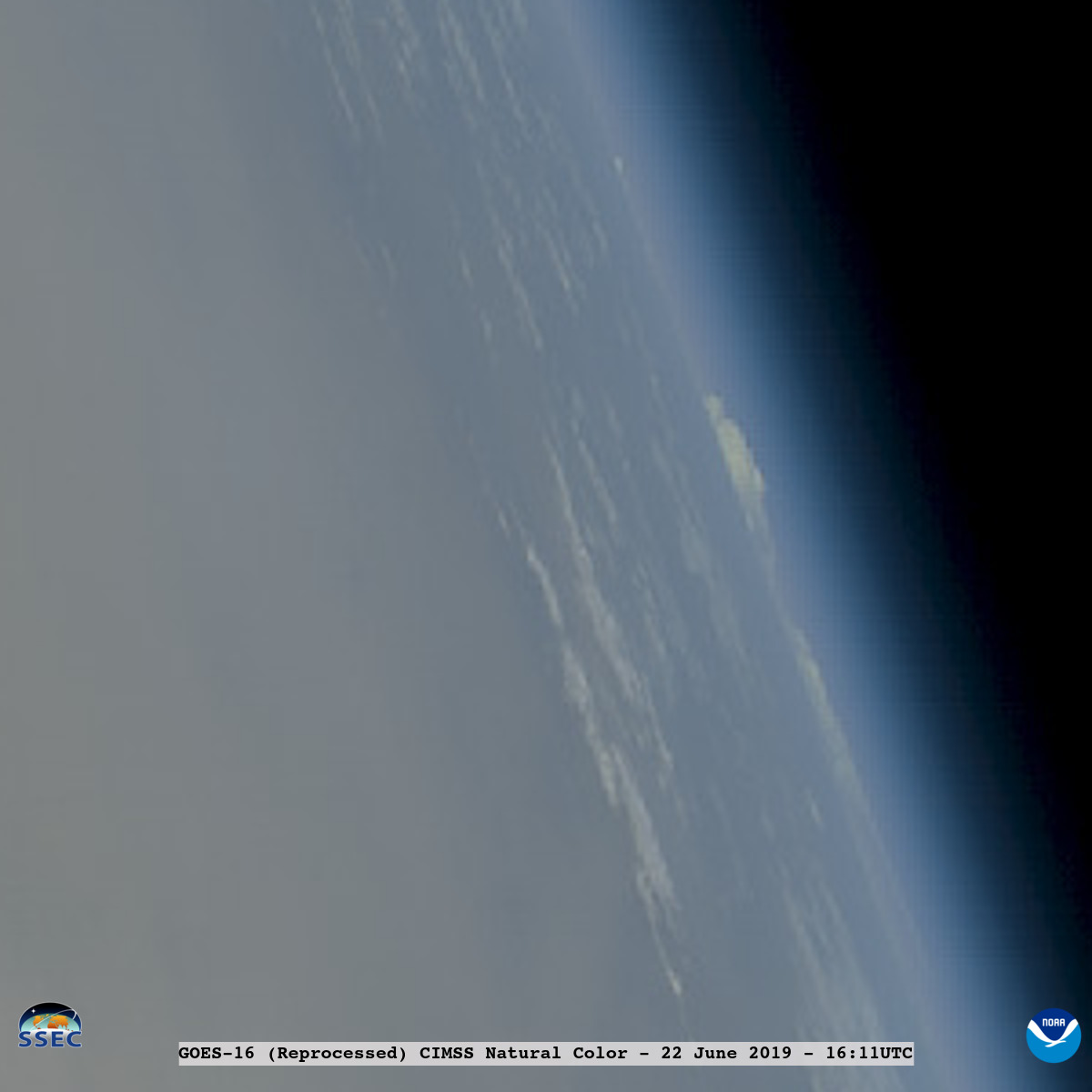
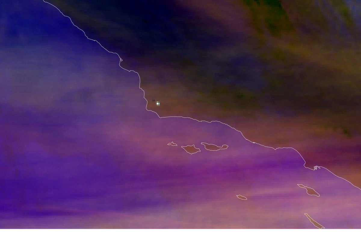
The Spin-Scan Cloud Camera (@UW_AOS @UWSSEC) on @NASAEarth ATS-1 was launched on this day (#OTD) in 1966: nssdc.gsfc.nasa.gov/nmc/experiment… "Then" image: SSCC visible image from Dec 11, 1966 and a "Now" composite image from @NOAASatellites #GOES16 ABI (specially reprocessed). #geo2grid
Or, there's the preliminary, non-operational @NOAASatellites #GOES18 ABI "SO2" RGB: cimss.ssec.wisc.edu/satellite-blog… HT @UWSSEC @UWCIMSS #geo2grid @WxSatChat @CIMSS_Satellite
Distinct SO2 signature from the #MaunaLoaVolcano eruption in both the @NOAASatellites #GOES17/#GOESwest SO2 RGB and Ash RGB images: cimss.ssec.wisc.edu/satellite-blog… More from @WxSatChat: cimss.ssec.wisc.edu/satellite-blog… #HIwx
And monitoring the #JPSS2 launch with @NOAASatellites #GOES18 ABI: cimss.ssec.wisc.edu/satellite-blog… using the "rocket plume" RGB composite: cimss.ssec.wisc.edu/goes/OCLOFactS… #geo2grid @UWSSEC

Looks like @NOAASatellites's latest geostationary weather sat caught the launch of @NOAA's newest weather sat! This pic is from GOES-18, and the bright spot near the middle is the @ulalaunch Atlas-V carrying #JPSS2! 🚀
Advancements in #Polar2Grid and #Geo2Grid Image Creation Software @ametsoc #ams2022cmm @UWSSEC check it out: cimss.ssec.wisc.edu/csppgeo/geo2gr… @CIMSS_Satellite
The record-setting pace of the 2022 Alaska wildfire season continues, with thick smoke covering most of the northern half of the state yesterday - as seen in @NOAASatellites #GOES17/#GOESwest True Color RGB images created using @UWSSEC #Geo2Grid: cimss.ssec.wisc.edu/satellite-blog…
The record-setting pace of the 2022 Alaska wildfire season continues, with thick smoke covering most of the northern half of the state - as seen in @NOAASatellites #GOES17/#GOESwest True Color RGB images created using @UWSSEC #Geo2Grid: cimss.ssec.wisc.edu/satellite-blog… @NWSFairbanks #AKwx
This might be the first "interwoven" imagery from 2 @NOAASatellites ABI GOES (#GOES17 and #GOES18 -- preliminary, non-operational) to create a 30-sec loop ("red" visible band): cimss.ssec.wisc.edu/satellite-blog… over @NWSGJT. The remapped (#geo2grid) imagery are 1-min from each satellite.
Here's another @NOAASatellites #GOES16 view ... #SummerSolstice2022 (Image start at 10:10 UTC) @UWSSEC #geo2grid
Happy Solstice! #SummerSolstice2022 took place in the Northern Hemisphere at 4:13am CDT today. This #GOESEast image and the slant of the terminator illustrates Earth's maximum tilt [~23.5 degrees] toward the Sun, resulting in the longest day of the calendar year. Enjoy!
![UWCIMSS's tweet image. Happy Solstice!
#SummerSolstice2022 took place in the Northern Hemisphere at 4:13am CDT today. This #GOESEast image and the slant of the terminator illustrates Earth's maximum tilt [~23.5 degrees] toward the Sun, resulting in the longest day of the calendar year. Enjoy!](https://pbs.twimg.com/media/FVxi2tDWUAA9IFK.jpg)
.@NOAASatellites #GOES16/#GOESeast True Color RGB images (created using @UWSSEC #Geo2Grid) showed a brief plume of black smoke, which moved quickly NE -- caused by the collision of 2 semi-trucks just west of I-94 in southeastern WI: cimss.ssec.wisc.edu/satellite-blog… #WIwx
.@NOAASatellites #GOES16/#GOESeast True Color RGB images (created using @UWSSEC #Geo2Grid) showed a brief plume of black smoke, which moved quickly NE -- caused by the collision of 2 semi-trucks just west of I-94 in southeastern WI: cimss.ssec.wisc.edu/satellite-blog… @NWSMilwaukee #WIwx
#GOES16/#GOESeast True Color RGB images (created using @UWSSEC #Geo2Grid) revealed pyrocumulus clouds and the large smoke plume produced by the #ChipolaComplex, which extended into southwestern Georgia: cimss.ssec.wisc.edu/satellite-blog… #FLwx #GAwx
At SSEC we see a lot of full-disk images - and we never get tired of them. Happy #Earthday #geo2grid #PictureEarth #EarthWeek #GOESEast
Here's another @NOAASatellites #GOES16 view ... #SummerSolstice2022 (Image start at 10:10 UTC) @UWSSEC #geo2grid
Happy Solstice! #SummerSolstice2022 took place in the Northern Hemisphere at 4:13am CDT today. This #GOESEast image and the slant of the terminator illustrates Earth's maximum tilt [~23.5 degrees] toward the Sun, resulting in the longest day of the calendar year. Enjoy!
Advancements in #Polar2Grid and #Geo2Grid Image Creation Software @ametsoc #ams2022cmm @UWSSEC check it out: cimss.ssec.wisc.edu/csppgeo/geo2gr… @CIMSS_Satellite
And a similar view over @environmentca via @NOAASatellites ABIs, #GOES16 and #GOES17: cimss.ssec.wisc.edu/satellite-blog… Note the parallax between the views. @UWSSEC #geo2grid

Winter across Canada. This is the view from the @Space_Station of the @cityofcalgary to the @CityofRegina captured live from 420km above this morning at 11:19 PST. @CBCCalgary @CBCSask @csa_asc (Dec 15, 2021)
The Spin-Scan Cloud Camera (@UW_AOS @UWSSEC) on @NASAEarth ATS-1 was launched on this day (#OTD) in 1966: nssdc.gsfc.nasa.gov/nmc/experiment… "Then" image: SSCC visible image from Dec 11, 1966 and a "Now" composite image from @NOAASatellites #GOES16 ABI (specially reprocessed). #geo2grid
Something went wrong.
Something went wrong.
United States Trends
- 1. Thanksgiving 381K posts
- 2. Golesh 2,259 posts
- 3. Fani Willis 13.2K posts
- 4. Trumplican 2,937 posts
- 5. #WipersDayGiveaway N/A
- 6. Hong Kong 16.1K posts
- 7. Khabib 6,955 posts
- 8. Camp Haven 6,892 posts
- 9. Riker N/A
- 10. Tom Hardy 1,344 posts
- 11. Stranger Things 161K posts
- 12. Africans 26.5K posts
- 13. NextNRG N/A
- 14. Ruth 13.8K posts
- 15. #TejRan 4,071 posts
- 16. Elijah Moore 1,005 posts
- 17. Idris 7,545 posts
- 18. Fassbender N/A
- 19. #Wednesdayvibe 3,665 posts
- 20. Karoline Leavitt 29K posts