#cowx search results

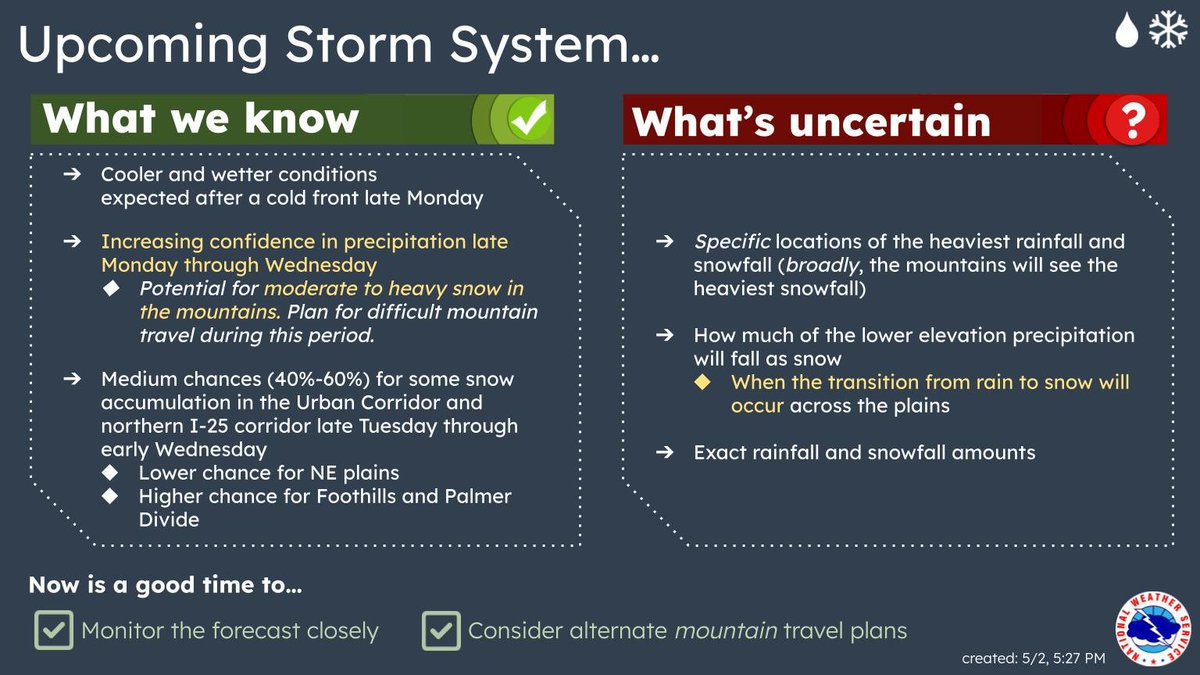
There’s potential for a strong system to impact our area late Monday through Wednesday. With this system, we could see cooler temps, snow in the mountains, and rain (and potentially some snow) across the plains. Stay tuned to the forecast for more updates as we get closer! #COwx

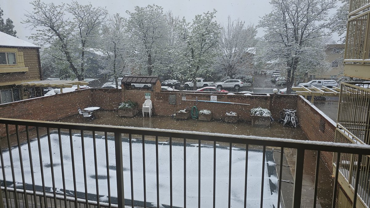
I never thought I'd say this but, YAYYY SNOW! Send us your #CrappySnowPhotoOfTheDay for a chance to be featured in the newsletter #cowx
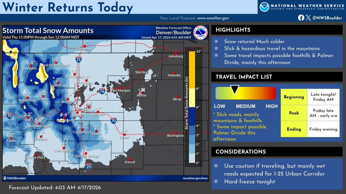
It will be much colder today as snow spreads across the area this morning. There will be some travel impacts in the mountains and across the southern foothills today and possibly over the higher elevations of the Palmer Divide along I-25 this afternoon. #cowx

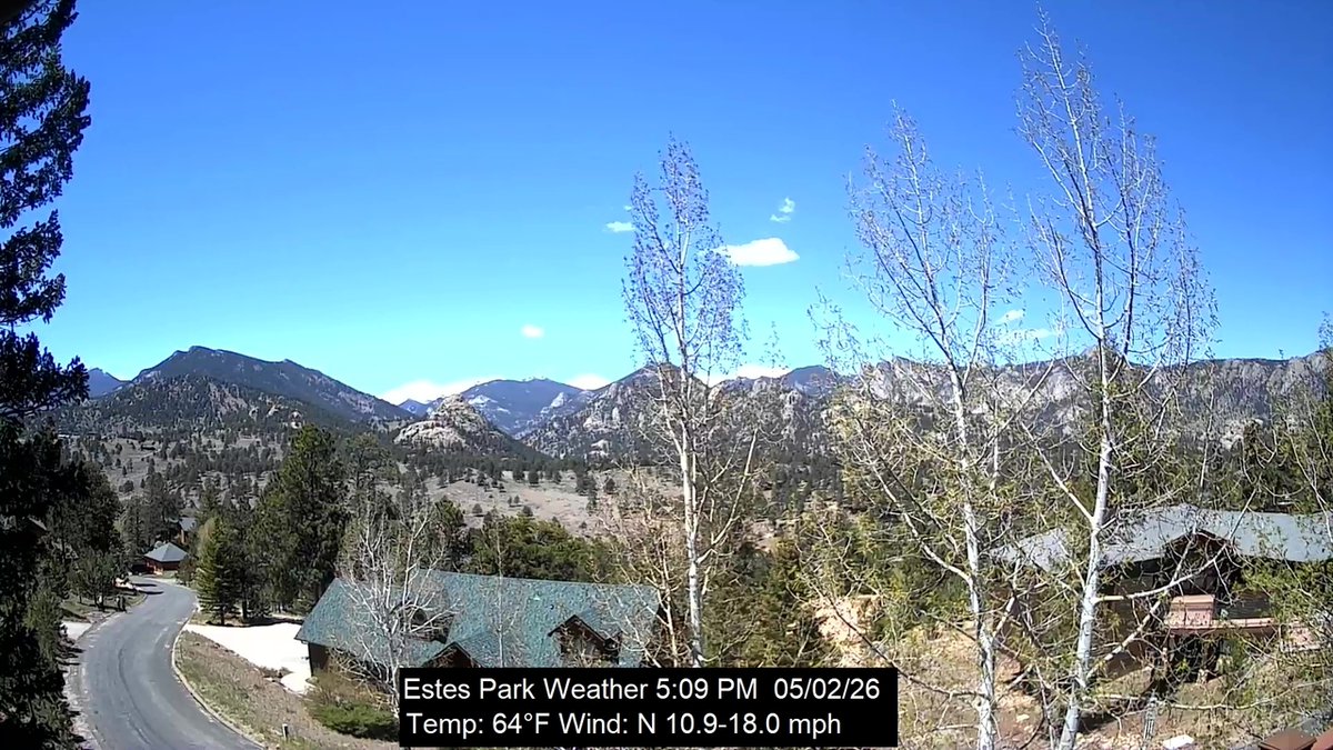
Estes Park, CO weather: mostly clear | 64F | humidity 16 | wind ESE 15.0 -> 18.0 | Today: 27F/66F Rain 0.00 | May 2, 2026 at 05:00PM #cowx


🌧️ Mostly cloudy with showers and a few rumbles of thunder after 2p. 70% chance for rain across the metro area, with a few localized downpours. High near 60°. 🌧️ Similar tomorrow with widespread afternoon showers, before a drier Tuesday and Wednesday. #COwx


If you participate in PRF or annual forage, here was April #cowx #wywx #newx #kswx #omwx #txwx #nmwx #desertfarmers

Map of the current Madatory Evacuations for the fire on the far west side of Fort Collins: Please see additional details at nocoalert.org #COwx #COfire
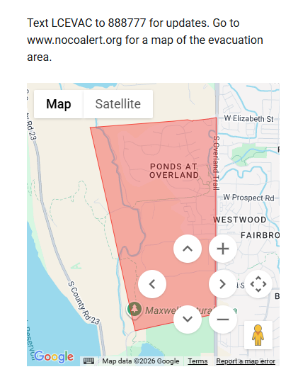

04-23-2026 17:08:24 For Accessible Alerts: leta.ahasalerts.com/?id=2457238300… Fort Collins, CO - Wildfire - Mandatory Evacuations ordered for residents west of Overland Trail, south of Elizabeth St to Dixon Canyon Rd. EVACUATION IS MANDAT manager.everbridge.net/pub/2457238300…
Most saw just a few hundredths of an inch of rain this afternoon (0.03" downtown here at 9NEWS), but a few spots south saw 0.1-0.25" of rain. The real rain's tomorrow...so I consider this all a bit of a bonus! #COwx

Despite Thursday's low pressure center likely staying way south in El Paso, most models still showing a drought-denting rain for parts of the Eastern Plains for Thursday. 1/2"+ possible in Denver, 1"+ on the Palmer Divide/south. Could be our biggest rain in months. #COwx

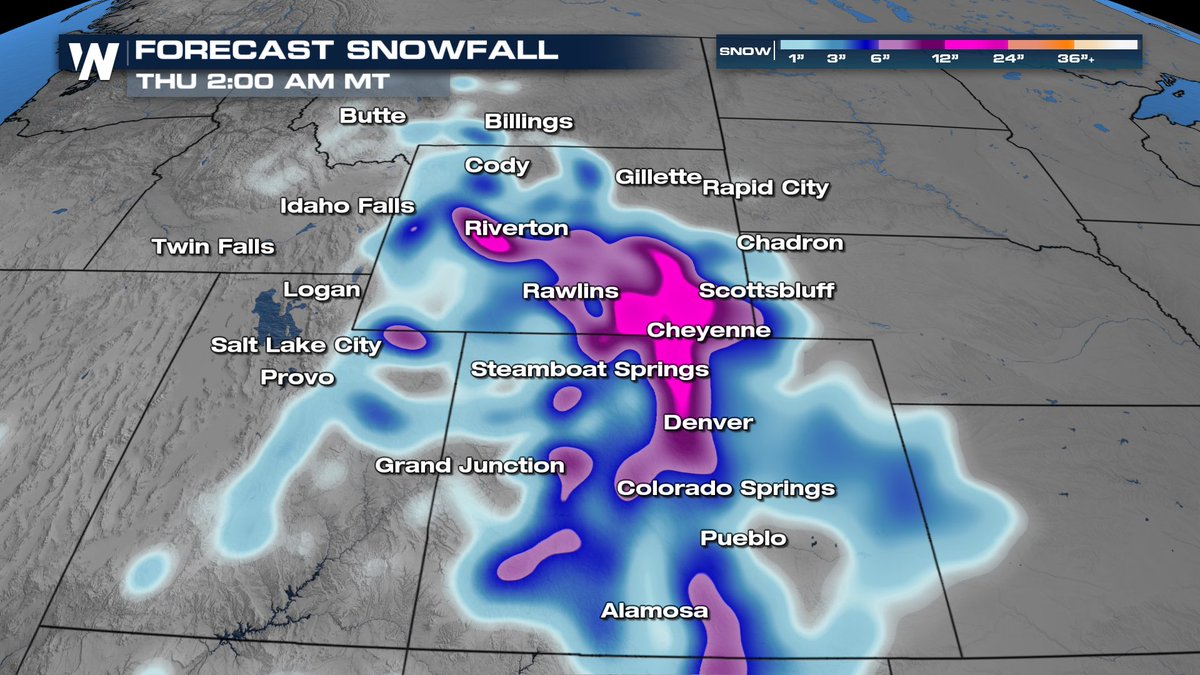
Updated snowfall amounts for the mountains through Friday. Slick roads certainly possible after sunset today. #cowx

Quiet now in Denver, but a burst of snow develops later this morning. Could briefly snow heavily, with a quick slushy inch or two of accumulation possible. Roads should stay mainly wet in town. #COwx


There'll be a sharp north-to-south gradient with tomorrow's rain. Denver's right on the edge of it, but still cautiously optimistic that Denver gets 1/2"+ of rain. Fort Collins, Greeley likely get skunked, while the foothills/Divide will have 1"+ rain/snow potential. #COwx

If you're wondering where the Denver area rain is and why forecast totals have cratered...the center of the area of low pressure is 1) way south in northern Mexico and 2) poorly defined. Still, we should see a few showers today/tonight from Denver on south and west. #COwx

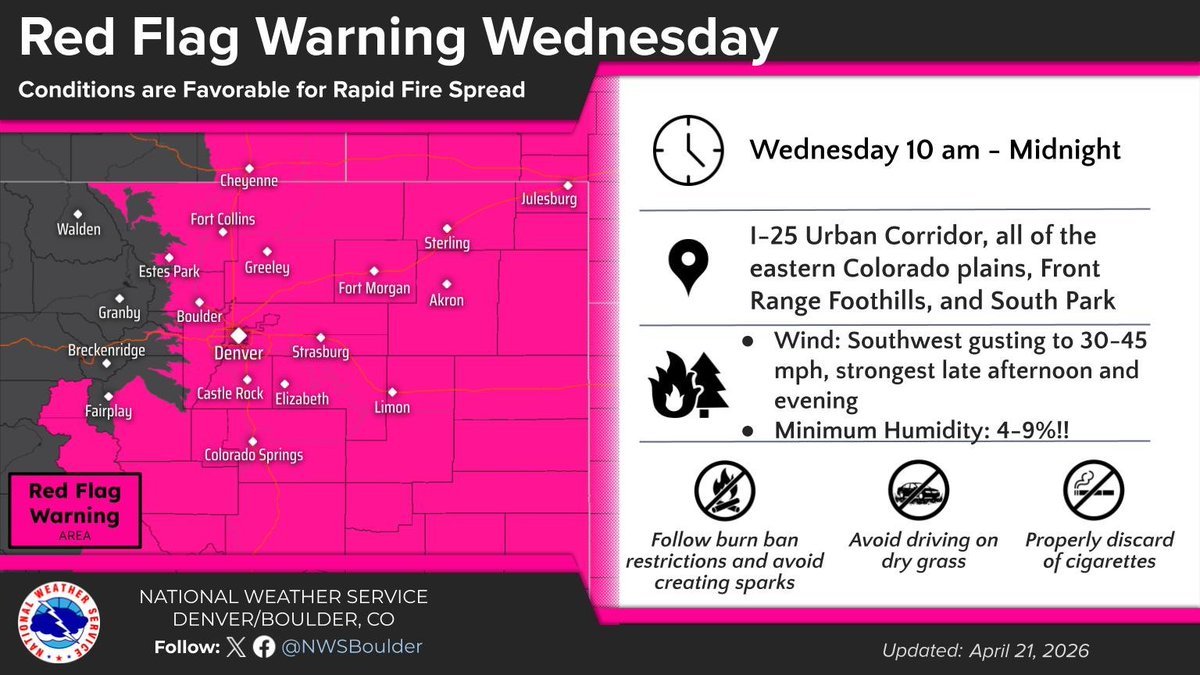
🔥Red Flag Warning Wednesday🔥 Widespread critical fire weather conditions and potential for rapid wildfire spread Wednesday. #COwx 🤔Plan ahead 🚫Any activity that may produce a spark ✅Follow instructions from local officials should a wildfire start
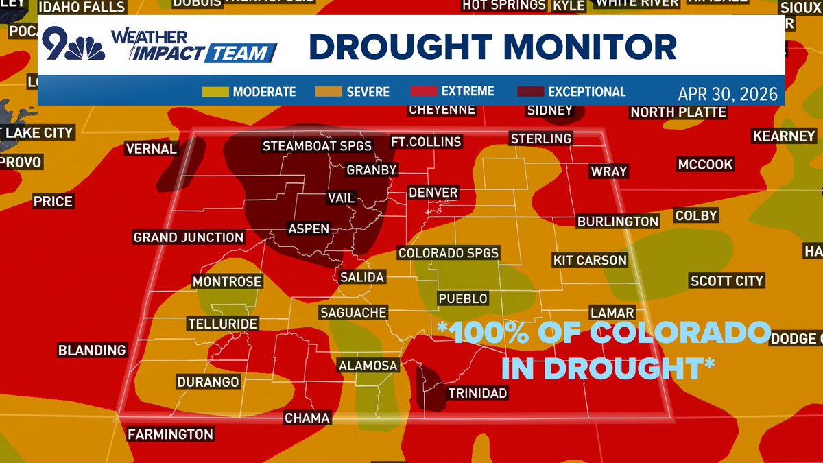
For the first time since Dec. 28, 2021: 100% of Colorado is in drought, per this week's drought monitor update. Perhaps worse is that 90% of the state is in severe or worse drought. 17.7% of the state is in the highest level of drought. Some minor help today/tomorrow. #COwx
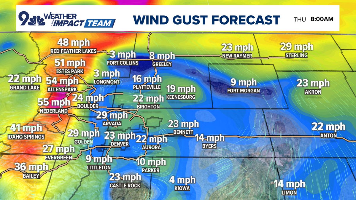
🌬️ Be smart today, Colorado: Windy with high fire danger, 30-40 mph gusts this afternoon in Denver (stronger south/west) and warm, high in the low 80s. 🍃 Front Range foothills stay windy tonight, 50-60+ mph gusts (may include Boulder/Hwy 93). Cooler tomorrow in Denver. #COwx

Positive: today will be Denver’s 5th-straight day with clouds, below average temps, and at least some rain. Downside: Rain amounts today continue to trend lower. Denver may be lucky to get 1/4” of rain today/tonight, with lower amounts north and east. #COwx

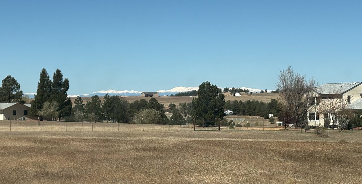
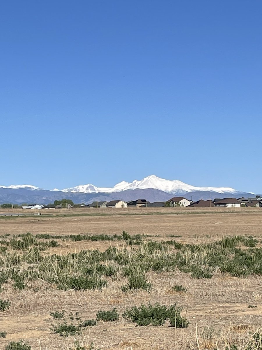
Hello from Colorado! This is how the mountains are supposed to look in April. It's pretty, but still nowhere near enough snow. We need water for stuff like... growing crops and staying alive. I'm hoping for a few months of "wet". #cowx
There’s potential for a strong system to impact our area late Monday through Wednesday. With this system, we could see cooler temps, snow in the mountains, and rain (and potentially some snow) across the plains. Stay tuned to the forecast for more updates as we get closer! #COwx
If you participate in PRF or annual forage, here was April #cowx #wywx #newx #kswx #omwx #txwx #nmwx #desertfarmers
Estes Park, CO weather: mostly clear | 64F | humidity 16 | wind ESE 15.0 -> 18.0 | Today: 27F/66F Rain 0.00 | May 2, 2026 at 05:00PM #cowx
Denver weather: Warm Sunday, but more rain next week #cowx kdvr.com/weather/weathe…


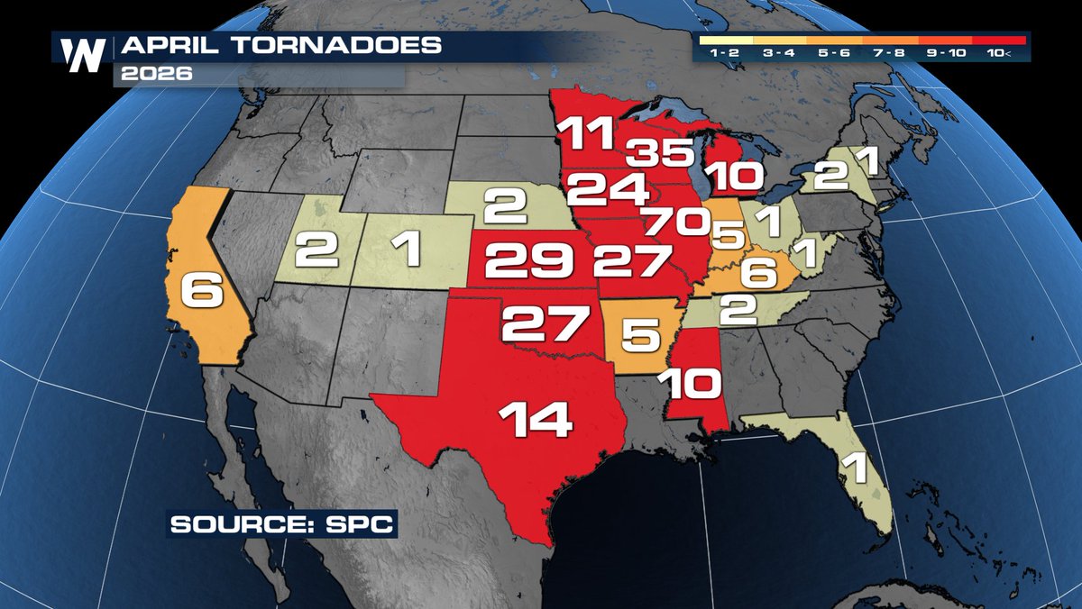
Colorado is on the 2026 Tornado board with 1 reported tornado storm report on 4/25 🌪️ #cowx


April 2026 ended with at least 292 tornadoes across the United States. As you can imagine, the states in the Plains and Upper Midwest saw the most while a quiet month in the South!
The warming trend continues for Sunday and Monday, then another system will bring the potential for widespread rain and snow across southern Colorado Tuesday and Wednesday. Keep an eye on the forecasts for the mid week storm. This one looks colder with lower snow levels. #cowx

Let's go again! Another storm could bring some more beneficial rain and snow to southern Colorado Tue-Wed. This one looks colder with the potential for snow to affect more of the I-25 corridor. Keep a close eye on the forecasts as we hone down the details. #cowx


Rocky Mountain forecast Next up 5/4 L🌧️ GSL basin Water supply 93% of median for Wasatch Front communities. #utwx #cowx #Idwx #wywx #SKI #Skiutah #skiIdaho #skicolorado #skiwyoming #nvwx #mtwx #CAwx #azwx youtube.com/watch?v=Wm_ANE…

youtube.com
YouTube
Chris Tomer

This looks fun. Wyoming/Colorado have good ensemble support for a solid May snow storm next Tuesday/Wednesday. Snow totals will change but this is at 8:1 and is a lot 👀 ❄️ #COwx
A short break in the gloomy weather allowed for a beautiful graduation at CU today. 65°. Thanks, Mother Nature! 🎓🌞⛰️ #COwx #Boulderwx #CUBoulder

❄️ Still plenty of uncertainty regarding wet spring storm that will move across the southern Rockies Tue/Wed of next week, but you should definitely not be moving forward with any garden planting this weekend in the Denver area. Wet snow/freezes on the table. Stay tuned #COWx
Hello from Colorado! This is how the mountains are supposed to look in April. It's pretty, but still nowhere near enough snow. We need water for stuff like... growing crops and staying alive. I'm hoping for a few months of "wet". #cowx


At 7:00 AM MDT, Silverton [San Juan Co, CO] Cocorahs reports Snow of 0.70 Inch. Cocorahs station CO-SJ-4 Silverton. #cowx mesonet.agron.iastate.edu/lsr/?by=wfo&wf…
![WCO_EUTWx's tweet image. At 7:00 AM MDT, Silverton [San Juan Co, CO] Cocorahs reports Snow of 0.70 Inch. Cocorahs station CO-SJ-4 Silverton. #cowx mesonet.agron.iastate.edu/lsr/?by=wfo&wf…](https://pbs.twimg.com/media/HHUveIeW4AE-DG9.jpg)

At 7:00 AM MDT, Silverton [San Juan Co, CO] Cocorahs reports Snow of 0.70 Inch. Cocorahs station CO-SJ-4 Silverton. #cowx mesonet.agron.iastate.edu/lsr/?by=wfo&wf…
![iembot_gjt's tweet image. At 7:00 AM MDT, Silverton [San Juan Co, CO] Cocorahs reports Snow of 0.70 Inch. Cocorahs station CO-SJ-4 Silverton. #cowx mesonet.agron.iastate.edu/lsr/?by=wfo&wf…](https://pbs.twimg.com/media/HHUveIVW4AInMJt.jpg)
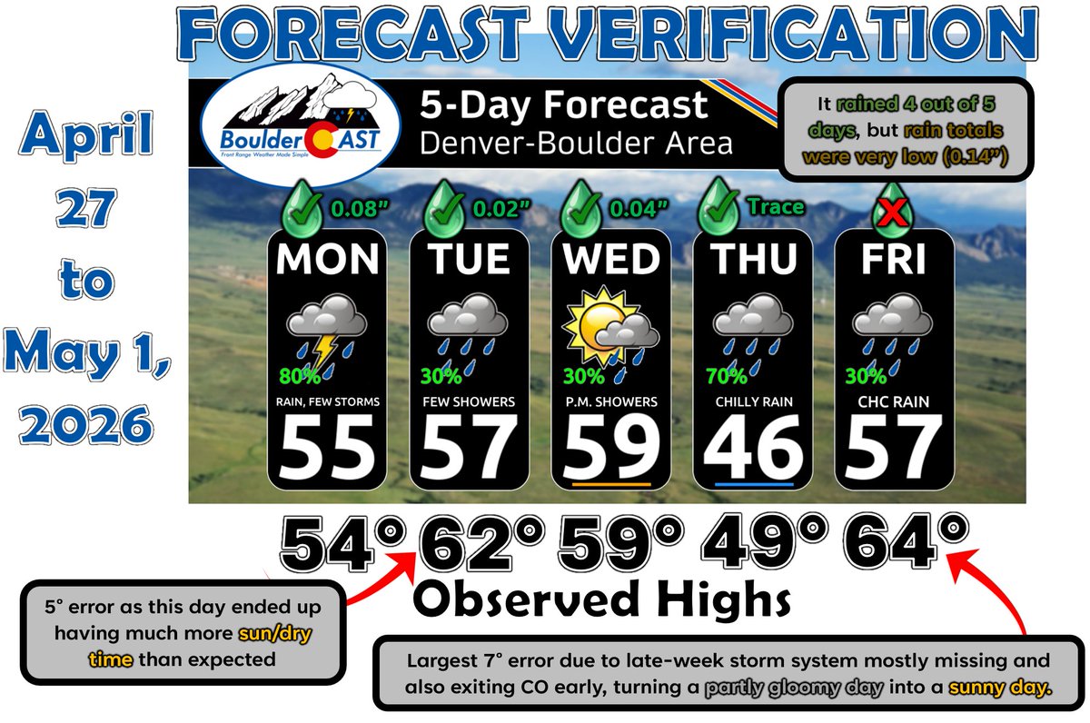
✅ Weekly outlook forecast verification for April 27-May 1, 2026. Forecast issued 7AM April 27th. Boulder official climate site (when possible) used for verification. #COWX #Boulder #BoulderCASTVerification
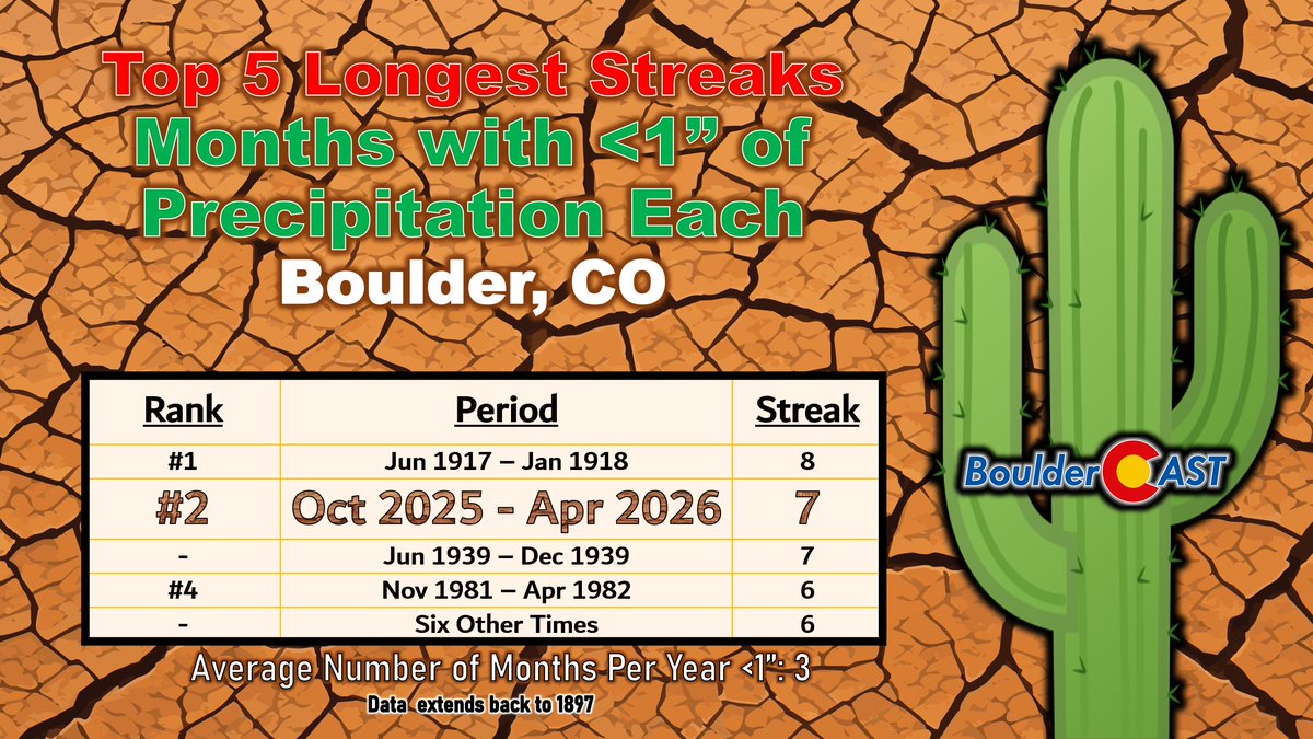
🏜️ April was Boulder's 7th straight month with below normal precipitation. This dry stretch has become the 2nd longest streak of months (7) where less than 1" of precipitation was recorded, only bested by a very dry period during WW1 (8 months). #COWX #Boulderwx #Drought

#FTB: A warming and drying trend will begin today. Outside of weak, isolated precipitation over the San Juan Mtns this afternoon/early evening, it should be a dry with seasonable temperatures returning. More #cowx details here: coloradofloodthreat.com/flood_threat_b…


It will be much colder today as snow spreads across the area this morning. There will be some travel impacts in the mountains and across the southern foothills today and possibly over the higher elevations of the Palmer Divide along I-25 this afternoon. #cowx
Despite Thursday's low pressure center likely staying way south in El Paso, most models still showing a drought-denting rain for parts of the Eastern Plains for Thursday. 1/2"+ possible in Denver, 1"+ on the Palmer Divide/south. Could be our biggest rain in months. #COwx
I never thought I'd say this but, YAYYY SNOW! Send us your #CrappySnowPhotoOfTheDay for a chance to be featured in the newsletter #cowx
Beautiful weekend -> storms Monday -> sharp cold front Tuesday + rain (maybe mix?) likely -> beautiful end to the week #COwx

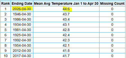
This was easily Denver's hottest January-April on record. Nearly a full degree warmer than Jan-April 1946. #COwx
🌧️ Rainy Thursday: After a bit of AM sun, clouds move in and showers around most of the day, steadiest after 2p. Some breaks in the rain. Heaviest rain south. May briefly flip to snow tonight, accumulation mainly above 6k feet. ⛅️ Drier tomorrow, warmer this weekend. #COwx

🌧️ Mostly cloudy with showers and a few rumbles of thunder after 2p. 70% chance for rain across the metro area, with a few localized downpours. High near 60°. 🌧️ Similar tomorrow with widespread afternoon showers, before a drier Tuesday and Wednesday. #COwx

Most saw just a few hundredths of an inch of rain this afternoon (0.03" downtown here at 9NEWS), but a few spots south saw 0.1-0.25" of rain. The real rain's tomorrow...so I consider this all a bit of a bonus! #COwx
If you're wondering where the Denver area rain is and why forecast totals have cratered...the center of the area of low pressure is 1) way south in northern Mexico and 2) poorly defined. Still, we should see a few showers today/tonight from Denver on south and west. #COwx
Map of the current Madatory Evacuations for the fire on the far west side of Fort Collins: Please see additional details at nocoalert.org #COwx #COfire
04-23-2026 17:08:24 For Accessible Alerts: leta.ahasalerts.com/?id=2457238300… Fort Collins, CO - Wildfire - Mandatory Evacuations ordered for residents west of Overland Trail, south of Elizabeth St to Dixon Canyon Rd. EVACUATION IS MANDAT manager.everbridge.net/pub/2457238300…
Updated snowfall amounts for the mountains through Friday. Slick roads certainly possible after sunset today. #cowx
There’s potential for a strong system to impact our area late Monday through Wednesday. With this system, we could see cooler temps, snow in the mountains, and rain (and potentially some snow) across the plains. Stay tuned to the forecast for more updates as we get closer! #COwx
NEW: Winter Weather Advisories for the mountains, with 5-13" above 8,000 feet. Passes/foothills/Monument Hill will all be slick tomorrow. Worst of it after dark. Winter Storm Warnings up for southern Colorado, where the Sangres could get a really good hit above 10k. #COwx

🔥Red Flag Warning Wednesday🔥 Widespread critical fire weather conditions and potential for rapid wildfire spread Wednesday. #COwx 🤔Plan ahead 🚫Any activity that may produce a spark ✅Follow instructions from local officials should a wildfire start
A short break in the gloomy weather allowed for a beautiful graduation at CU today. 65°. Thanks, Mother Nature! 🎓🌞⛰️ #COwx #Boulderwx #CUBoulder
For the first time since Dec. 28, 2021: 100% of Colorado is in drought, per this week's drought monitor update. Perhaps worse is that 90% of the state is in severe or worse drought. 17.7% of the state is in the highest level of drought. Some minor help today/tomorrow. #COwx
Most areas will stay dry today as we begin to warm again. Only a few light rain and snow showers will be possible through this afternoon, mainly for the mountains and along/south of I-70. #COwx

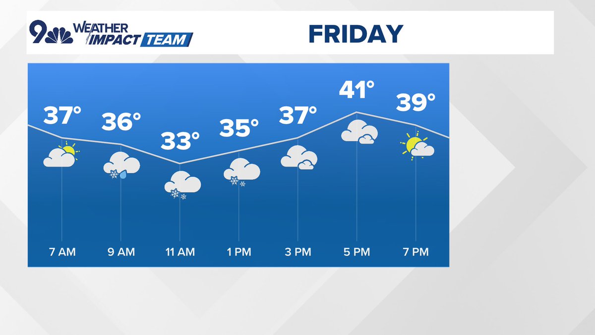
❄️ Snow way: It was 77° yesterday, but we'll struggle to hit 40° today with snow from 9a-6p. Heaviest 9a-2p. A trace to maybe 1-2" of slushy snow in Denver, 3"+ foothills above 7k. 🥶 Hard freeze tonight with lows in the low 20s. Sunnier/warmer (mid-50s) tomorrow. #COwx
Denver area winds probably peak tonight/tomorrow morning. Foothills above timberline will have 60+ mph gusts late tonight/early tomorrow. Boulder/Hwy 93 may see 50-60 mph gusts briefly late tonight/early tomorrow. Denver peak winds of 30-40 mph tonight/early tomorrow. #COwx
Something went wrong.
Something went wrong.
United States Trends
- 1. Golden Tempo N/A
- 2. #KentuckyDerby N/A
- 3. Great White N/A
- 4. Cherie DeVaux N/A
- 5. Tatum N/A
- 6. NINGNING NYC TAKEOVER N/A
- 7. So Happy N/A
- 8. Jaylen Brown N/A
- 9. Renegade N/A
- 10. Celtics N/A
- 11. Spirit N/A
- 12. Jose Ortiz N/A
- 13. Further Ado N/A
- 14. Chief Wallabee N/A
- 15. Luka Garza N/A
- 16. Emerging Market N/A
- 17. Reds N/A
- 18. Ron Harper Jr. N/A
- 19. Tucker N/A
- 20. #MetGala2026 N/A