#kotaweather ผลการค้นหา


#राजस्थान_मौसम #Rajasthan_Weather_Report #KotaWeather #Jaipur_Weather_Today #Rajasthan_Weather #Rajasthan_Weather_Alert #Rajasthan_Weather_News


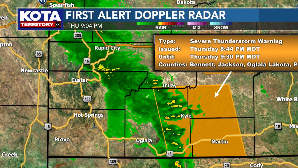
Severe Storm in the Badlands! A Severe Storm Warning is in effect for the Badlands until 9:30pm. The storm is producing winds to 60 mph and should die down around 10pm. No hail is indicated on Doppler radar. #sdwx #kotaweather
A SEVERE THUNDERSTORM WARNING is in effect for Lawrence & Meade counties until 3:30PM. This storm has the potential to produce quarter sized hail & wind gusts up to 60mph. Areas impacted include Galena, Apple Springs, Sturgis, Fort Meade, Tilford & Dalton Lake. #sdwx #KOTAWeather

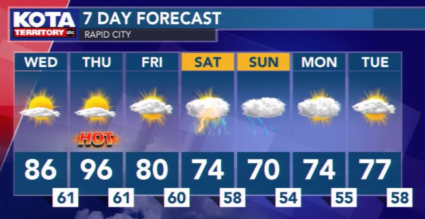
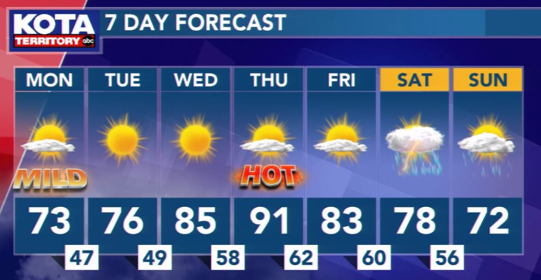
The heat is on tomorrow! We'll have a mostly cloudy weekend with chances for showers and thunderstorms beginning Friday night #kotaweather
A SEVERE THUNDERSTORM WARNING is in effect for Custer, Meade & Pennington counties until 5:15PM. Wind gusts up to 60 mph & ping pong ball sized hail (1.5" diameter) are likely. Areas impacted include Box Elder, Caputa, New Underwood & Farmingdale. #sdwx #KOTAWeather
A SEVERE THUNDERSTORM WARNING is in effect for Crook & Weston counties until 4:15PM. Wind gusts up to 60 mph & quarter sized hail (1" diameter) are likely with this storm. Upton is in the path of the storm. #wywx #KOTAWeather

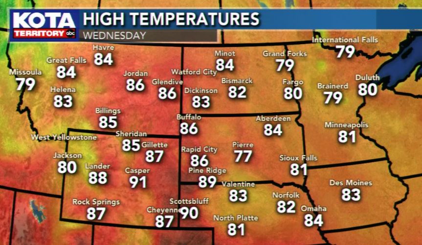
Today's forecast is a hole in one! Conditions are warmer than yesterday as we see plentiful sunshine! Perfect afternoon to be outside, but grab the sunscreen as you could get a sunburn in as little as 20 minutes! Enjoy today as the holiday weekend sees some changes! #KOTAWeather

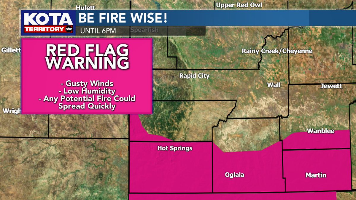
Another day of Red Flag Warnings in effect for portions of southwest & south-central South Dakota. Breezy & dry conditions will result in conditions favorable for a fire to start easily and spread quickly. We can't stress this enough -- be fire wise! #KOTAWeather #sdwx
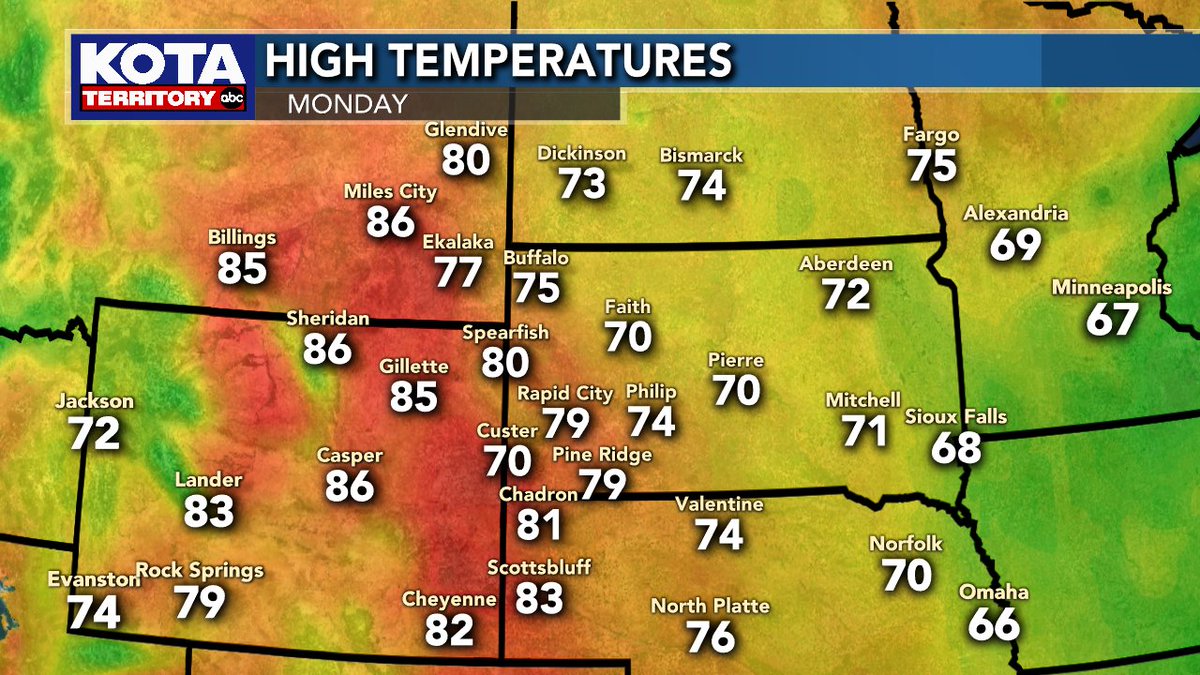
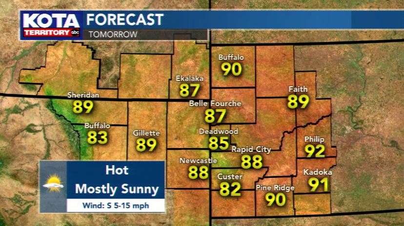
On Monday, we turn up the heat as temperatures climb into the 70s and 80s across the region! Rapid City will be a degree shy of the big 8-0, but it will still feel pleasant with mostly sunny skies. It will be breezy as gusts could reach 40 mph during the day! #KOTAWeather
Tomorrow will be HOT, triple digits in some spots. Scattered severe storms are possible late tomorrow and tomorrow night #kotaweather

A SEVERE THUNDERSTORM WARNING is in effect for Meade County until 4:15PM. Wind gusts up to 60 mph & half-dollar sized hail (1.25" diameter) are likely with this storm. Areas impacted include Sturgis, Tilford, & portions of I-90 between milemarker 30 & 41. #sdwx #KOTAWeather

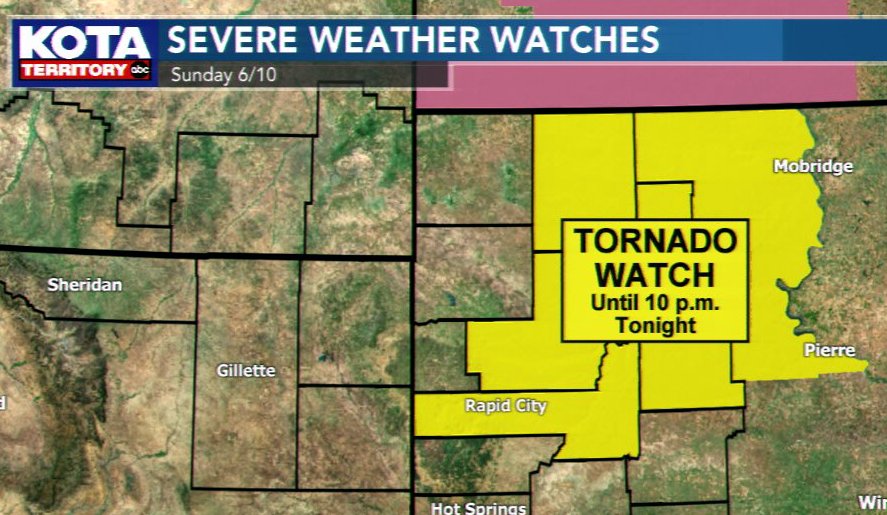
Tornado watches have been discontinued for parts of KOTA Territory. Here's whats left. #kotaweather #sdwx #wywx
The sun finally burned off those low clouds over Rapid City & our temperature is climbing quickly now! Up to 83° this afternoon w/ severe thunderstorms possible throughout #kotaweather
Much cooler to start the week (but actually right near average for this time of year). A quiet week with plentiful sunshine. #kotaweather

Live weather team coverage continues on #KOTANoonNews #kotaweather #sdwx #sdsnow @KOTAWeather @kotatweets

*HEADS UP* Severe thunderstorms are possible today from late this afternoon into tonight! Main threats: hail & wind gusts. Isolated tornado possible #kotaweather

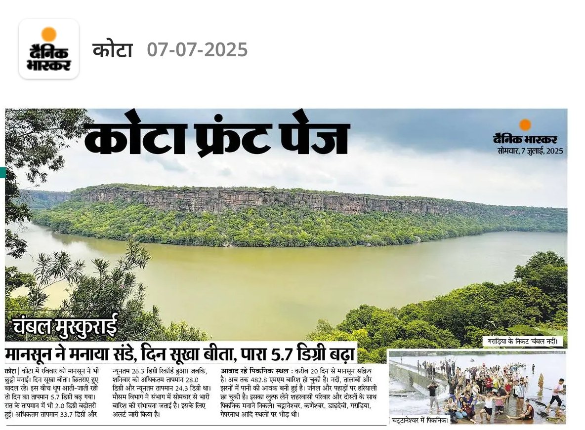
😎 मानसून बोला – 'इतना भी क्या बरसना हर रोज़?' कोटा वालों को दी धूप की ट्रीट – चंबल किनारे संडे डेट 💚 पारा बोला – 'लो मैं 5.7 डिग्री ऊपर चला गया, बाकी तुम झूला झूलो!' #KotaWeather #ChambalLove #DainikBhaskar

राजस्थान में मौसम ने एक बार फिर करवट ली #RajasthanWeather #JaipurRain #KotaWeather #Chittorgarh #HailstormAlert #ColdWave #AmritsarJamnagarExpressway #SuratgarhAccident #WinterChill #WeatherAlert #StaySafe #RainyDay #ColdWeather
#राजस्थान_मौसम #Rajasthan_Weather_Report #KotaWeather #Jaipur_Weather_Today #Rajasthan_Weather #Rajasthan_Weather_Alert #Rajasthan_Weather_News
#राजस्थान_मौसम #Rajasthan_Weather_Report #KotaWeather #Jaipur_Weather_Today #Rajasthan_Weather #Rajasthan_Weather_Alert #Rajasthan_Weather_News

#RajasthanWinter #Kota #KotaWeather #ModerateFog #RajasthanCold #WeatherReport #WeatherUpdate #DecemberCold #StaySafe @moesgoi @DDNewslive @ndmaindia @airnewsalerts @RajCMO @PIBJaipur @IMDJaipur
#RajasthanWinter #Kota #KotaWeather #ModerateFog #RajasthanCold #WeatherReport #WeatherUpdate #DecemberCold #StaySafe @moesgoi @DDNewslive @ndmaindia @airnewsalerts @RajCMO @PIBJaipur @IMDJaipur

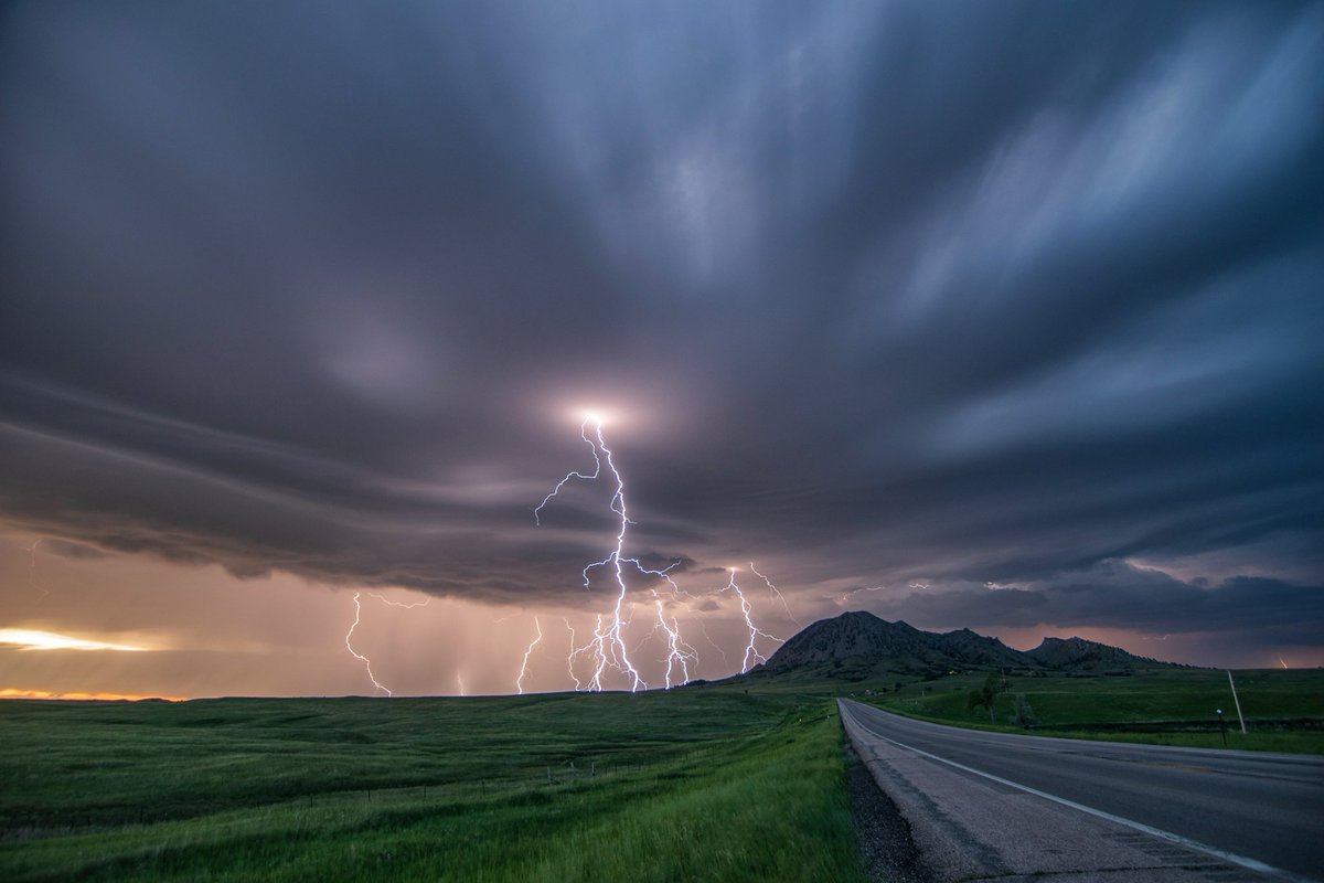
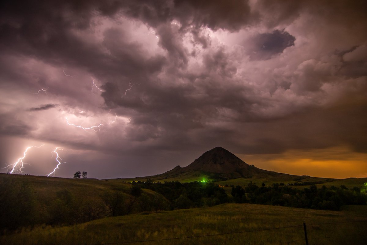
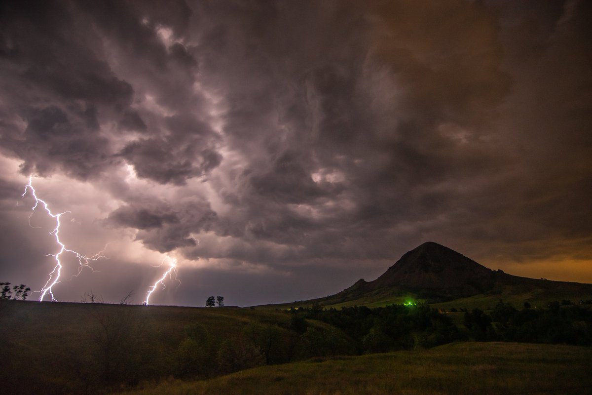
@NWSRapidCity @ReedTimmerAccu @StormHour Thursday night turned out less active than originally forecasted with an enhanced risk, but it still put on a show at Bear Butte! Mission accomplished. #SDwx #kotaweather #stormchasing #weather #picoftheday #thunderstorm #stormscape

Spotty showers will begin throughout the night and continue into tomorrow. Temperatures are expected to warm up as we head into tomorrow and continue to rise throughout the week. #KOTA #KOTAWeather #RapidCityWeather

Most, if not, all of the counties in KOTA Territory will likely see this watch drop as the storms have moved to the southeast. #sdwx #KOTAWeather
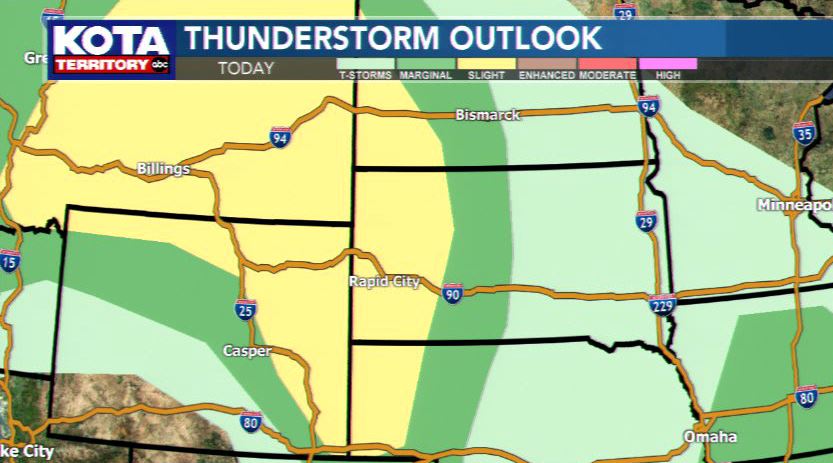
A Severe T-Storm Watch is in effect for western SD until 7pm. Isolated storms with large hail and/or wind gusts 60-70 mph will be possible this afternoon. Keep your TV on KOTA Territory and download the KOTA Mobile Weather app for your phone to stay ahead of the storms! #sdwx

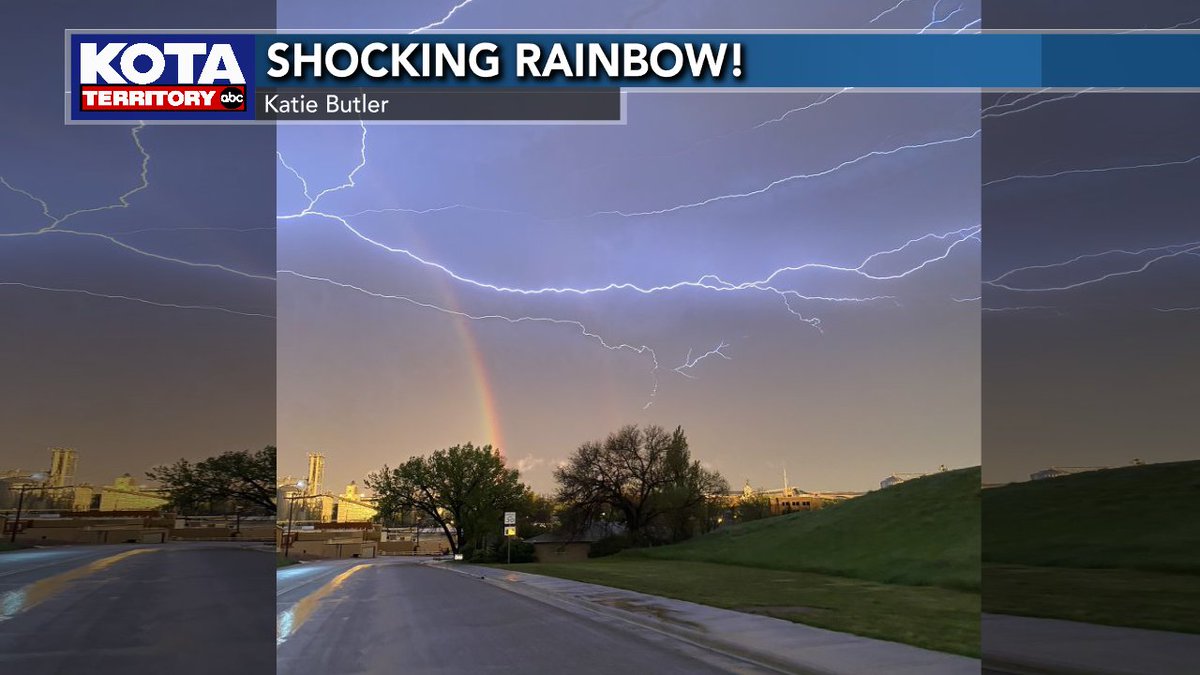
WOW!! Thanks to Katie Butler who sent us this photo of a shocking rainbow! Talk about a light show! If you have any photos or videos you'd like to submit to us, you can do so by going to kotatv.com/ugc! #KOTAWeather #sdwx #wywx #mtwx #ViewerPhoto
Today's forecast is a hole in one! Conditions are warmer than yesterday as we see plentiful sunshine! Perfect afternoon to be outside, but grab the sunscreen as you could get a sunburn in as little as 20 minutes! Enjoy today as the holiday weekend sees some changes! #KOTAWeather
Severe storms are likely Wednesday late afternoon and evening! Keep your TV set on KOTA Territory and have the KOTA Mobile Weather App on your smartphone to stay ahead of the storms! #sdwywx #kotaweather
On Monday, we turn up the heat as temperatures climb into the 70s and 80s across the region! Rapid City will be a degree shy of the big 8-0, but it will still feel pleasant with mostly sunny skies. It will be breezy as gusts could reach 40 mph during the day! #KOTAWeather
A SEVERE THUNDERSTORM WARNING is in effect for Custer, Meade & Pennington counties until 5:15PM. Wind gusts up to 60 mph & ping pong ball sized hail (1.5" diameter) are likely. Areas impacted include Box Elder, Caputa, New Underwood & Farmingdale. #sdwx #KOTAWeather
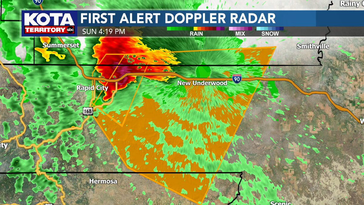
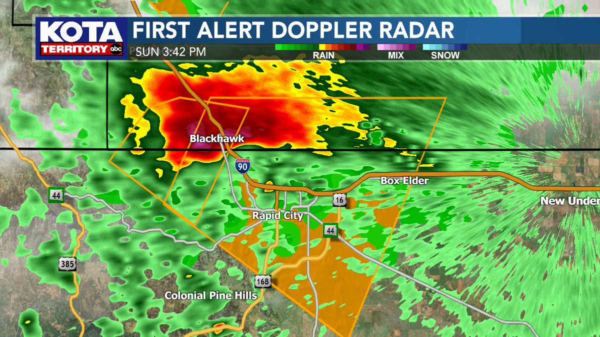
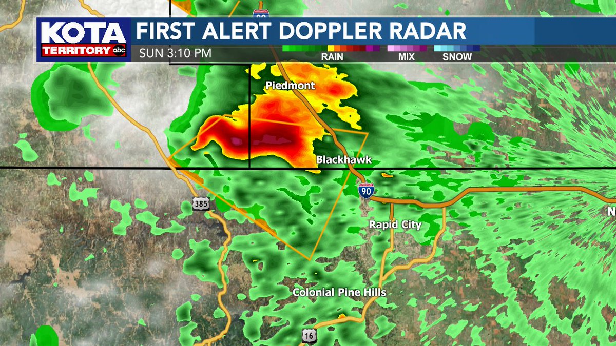
A SEVERE THUNDERSTORM WARNING is in effect for Meade & Pennington counties until 4:30PM. Wind gusts up to 60 mph & ping pong ball sized hail are likely with this storm. AREAS IMPACTED INCLUDE: Black Hawk, Rapid City, Rapid Valley, Box Elder & Ellsworth AFB. #sdwx #KOTAWeather
A SEVERE THUNDERSTORM WARNING is in effect for Crook & Weston counties until 4:15PM. Wind gusts up to 60 mph & quarter sized hail (1" diameter) are likely with this storm. Upton is in the path of the storm. #wywx #KOTAWeather
A SEVERE THUNDERSTORM WARNING is in effect for Meade County until 4:15PM. Wind gusts up to 60 mph & half-dollar sized hail (1.25" diameter) are likely with this storm. Areas impacted include Sturgis, Tilford, & portions of I-90 between milemarker 30 & 41. #sdwx #KOTAWeather
A SEVERE THUNDERSTORM WARNING is in effect for Lawrence, Meade & Pennington counties until 3:45PM. This storm will likely have wind gusts up to 60 mph & ping pong ball sized hail (1.5" diameter). Areas impacted include Summerset, Johnson Siding, & Black Hawk #sdwx #KOTAWeather
A SEVERE THUNDERSTORM WARNING is in effect for Lawrence & Meade counties until 3:30PM. This storm has the potential to produce quarter sized hail & wind gusts up to 60mph. Areas impacted include Galena, Apple Springs, Sturgis, Fort Meade, Tilford & Dalton Lake. #sdwx #KOTAWeather


On Monday, we turn up the heat as temperatures climb into the 70s and 80s across the region! Rapid City will be a degree shy of the big 8-0, but it will still feel pleasant with mostly sunny skies. It will be breezy as gusts could reach 40 mph during the day! #KOTAWeather
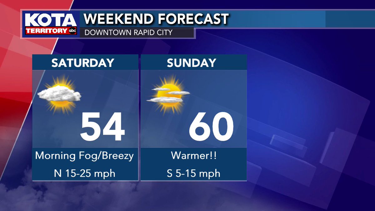
Skies will be overcast for most of today with rain, snow & fog for many, but we do expect improving conditions over the weekend! Fog will persist into early Saturday followed by breezy conditions. Sunday is looking FANTASTIC though! Have a great weekend! #KOTAWeather #sdwx #wywx
Severe Storm in the Badlands! A Severe Storm Warning is in effect for the Badlands until 9:30pm. The storm is producing winds to 60 mph and should die down around 10pm. No hail is indicated on Doppler radar. #sdwx #kotaweather
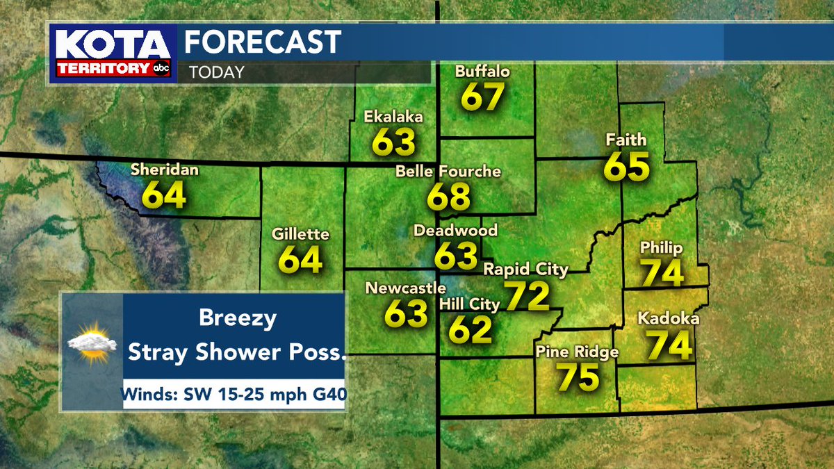
We have another nice day outside for the start of the week, though it will be breezy as gusts could reach over 40 mph at times. A stray shower is also possible this afternoon in portions of the hills and plains, but most will be dry. Don't forget to stay #FireWise! #KOTAWeather
Another day of Red Flag Warnings in effect for portions of southwest & south-central South Dakota. Breezy & dry conditions will result in conditions favorable for a fire to start easily and spread quickly. We can't stress this enough -- be fire wise! #KOTAWeather #sdwx
A SEVERE THUNDERSTORM WARNING is in effect for Lawrence & Meade counties until 3:30PM. This storm has the potential to produce quarter sized hail & wind gusts up to 60mph. Areas impacted include Galena, Apple Springs, Sturgis, Fort Meade, Tilford & Dalton Lake. #sdwx #KOTAWeather
Today's forecast is a hole in one! Conditions are warmer than yesterday as we see plentiful sunshine! Perfect afternoon to be outside, but grab the sunscreen as you could get a sunburn in as little as 20 minutes! Enjoy today as the holiday weekend sees some changes! #KOTAWeather
The heat is on tomorrow! We'll have a mostly cloudy weekend with chances for showers and thunderstorms beginning Friday night #kotaweather
A SEVERE THUNDERSTORM WARNING is in effect for Crook & Weston counties until 4:15PM. Wind gusts up to 60 mph & quarter sized hail (1" diameter) are likely with this storm. Upton is in the path of the storm. #wywx #KOTAWeather
A SEVERE THUNDERSTORM WARNING is in effect for Meade County until 4:15PM. Wind gusts up to 60 mph & half-dollar sized hail (1.25" diameter) are likely with this storm. Areas impacted include Sturgis, Tilford, & portions of I-90 between milemarker 30 & 41. #sdwx #KOTAWeather
Live weather team coverage continues on #KOTANoonNews #kotaweather #sdwx #sdsnow @KOTAWeather @kotatweets
Tomorrow will be HOT, triple digits in some spots. Scattered severe storms are possible late tomorrow and tomorrow night #kotaweather
The heat is on to start the work week! We could see an isolated thunderstorm in northern Hills tomorrow afternoon, otherwise hot & sunny #notsummeryet #kotaweather
A SEVERE THUNDERSTORM WARNING is in effect for Lawrence, Meade & Pennington counties until 3:45PM. This storm will likely have wind gusts up to 60 mph & ping pong ball sized hail (1.5" diameter). Areas impacted include Summerset, Johnson Siding, & Black Hawk #sdwx #KOTAWeather
A SEVERE THUNDERSTORM WARNING is in effect for Custer, Meade & Pennington counties until 5:15PM. Wind gusts up to 60 mph & ping pong ball sized hail (1.5" diameter) are likely. Areas impacted include Box Elder, Caputa, New Underwood & Farmingdale. #sdwx #KOTAWeather
*HEADS UP* Severe thunderstorms are possible today from late this afternoon into tonight! Main threats: hail & wind gusts. Isolated tornado possible #kotaweather
Tornado watches have been discontinued for parts of KOTA Territory. Here's whats left. #kotaweather #sdwx #wywx
Much cooler to start the week (but actually right near average for this time of year). A quiet week with plentiful sunshine. #kotaweather
Something went wrong.
Something went wrong.
United States Trends
- 1. #WWERaw N/A
- 2. Knicks N/A
- 3. Brunson N/A
- 4. Mike Brown N/A
- 5. CJ McCollum N/A
- 6. Jamal Murray N/A
- 7. Hawks N/A
- 8. Mikal Bridges N/A
- 9. #bucciovertimechallenge N/A
- 10. #RawAfterMania N/A
- 11. Sol Ruca N/A
- 12. Thune N/A
- 13. Foligno N/A
- 14. Wolves N/A
- 15. Brandon Ingram N/A
- 16. Kuminga N/A
- 17. Penguins N/A
- 18. #TrueToAtlanta N/A
- 19. Pens N/A
- 20. Street Profits N/A