#lpdaac search results

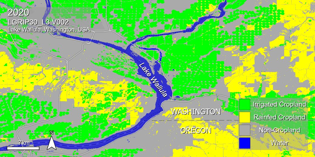
New data! NASA’s #LPDAAC has released five new #Landsat-Derived Global Rainfed and Irrigated-Cropland Product (LGRIP) Version 2 datasets that map #agriculture for 2020 in the conterminous United States. * Global data to be added later* Access data: go.nasa.gov/4fXAmGI
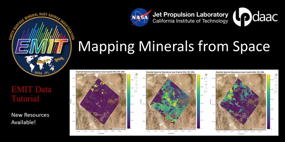
New #Python Tutorial! A new Jupyter Notebook tutorial developed by NASA's Land Processes DAAC (#LPDAAC) shows you how to work with NASA's EMIT L2B Estimated Mineral Identification and Band Depth and Uncertainty data. Access Notebook: go.nasa.gov/3WAVA6a

New ECOSTRESS products available! 70 m soil moisture, relative humidity, air temperature, net radiation 😮! lpdaac.usgs.gov/news/more-ecos… #lpdaac #appeears

🎉 New #GEDI datasets just dropped! 🎉 The #LPDAAC (@NASAEarthData) and @ORNLDAAC have released updated L1B, L2A, L2B, and L4A datasets to the public, completing the version 2 suite for these products. L4B product is forthcoming! bit.ly/LPDAAC bit.ly/ORNLDAAC
New data! NASA’s #LPDAAC has released the Terra+Aqua Combined #MODIS Version 6.1 Bidirectional Reflectance Distribution Function (BRDF) and Albedo Gap-Filled Snow-Free Daily L3 Global 30ArcSec Climate Modelling Grid (CMG) data product. ➡️Access data: go.nasa.gov/3UXTDzL

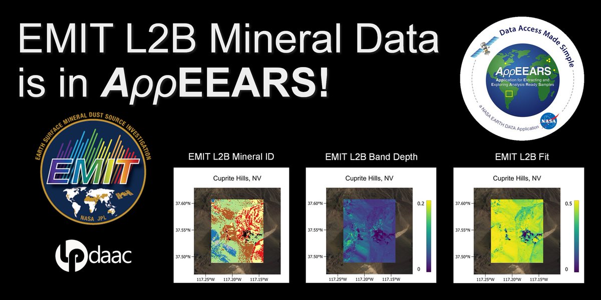
NASA’s Application for Extracting and Exploring Analysis Ready Samples #AppEEARS now supports point-and-area based data sampling requests for mineral data from the @NASAJPL EMIT mission! #LPDAAC #NASAEMIT Get started at: appeears.earthdatacloud.nasa.gov
Are you looking for #CO2 #emission data? Check out the new EMIT Level-2B Carbon Dioxide Enhancement and Level-2B Estimated Carbon Dioxide Plume Complexes 60 m data products at NASA's #LPDAAC! #GHG Access the new products: go.nasa.gov/4cqlSgT

NASA’s #LPDAAC and the ASTER Science Team @NASAJPL announced a final data processing campaign that will make the entire ASTER data archive freely available and easily accessible to users around the globe. ➡️Learn what this means for data users: go.nasa.gov/4ggJGoG

New Data! The 2005 epoch of the NASA #MEaSUREs Global Web-Enabled #Landsat Data (GWELD) Version 3.2 monthly and annual global 30-meter products are now available from NASA's #LPDAAC. For more information: go.nasa.gov/4eeDfC4

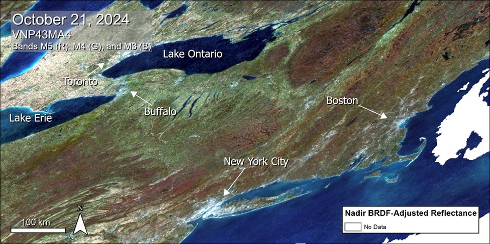
Now Available: #VIIRS Version 2 Albedo, BRDF, and NBAR Tiled Data Products from the Suomi-NPP and NOAA-20 satellites. This image showcases a natural color composite of eastern North America from the VNP43MA4 product. ➡️Learn more at NASA's #LPDAAC: go.nasa.gov/48FFv3r
NASA #LPDAAC's GEDI Version 2 Level 1B Geolocated Waveform, Level 2A Elevation and Height Metrics, and Level 2B Canopy Cover and Vertical Profile Metrics products are now available in the NASA Earthdata Cloud. Basemap: USAID NAIP 2020 Learn more: go.nasa.gov/4eNotT7

Find webinars, tutorials, and video tips at NASA's #LPDAAC for accessing and working with land processes data from missions like EMIT, GEDI, and ECOSTRESS using a variety of software, web applications, custom tools, and scripts. ➡️Access resources: go.nasa.gov/4fpkvk8

NASA's Application for Extracting and Exploring Analysis Ready Samples (AρρEEARS) now provides a “Spectral Comparison” tab allowing visualization of point samples from the Earth Surface Mineral Dust Source Investigation (EMIT) mission. #LPDAAC Learn more: go.nasa.gov/4fswYTK
Now Available: NASA’s Land Processes DAAC (#LPDAAC) released VIIRS Version 2 Land Surface Phenology data products from the Suomi-NPP satellite. Learn more about the products and access data: go.nasa.gov/4auZBP2
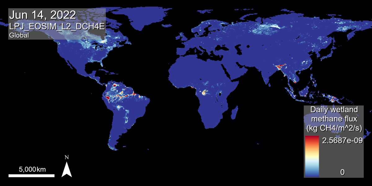
Four new #GHG datasets are available at NASA's #LPDAAC. The new LPJ-EOSIM L2 Global Simulated Wetland #Methane Flux data products are available in daily and monthly temporal resolutions with high latency and low latency delivery schedules. Access data: go.nasa.gov/3xQHXGC
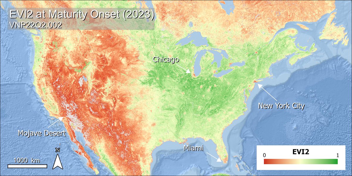
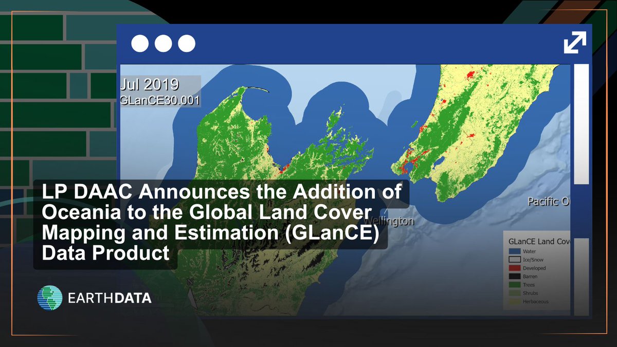
GLanCE is growing! The Landsat-derived Global Land Cover Mapping and Estimation product now includes data over Oceania. Use a greenness index (EVI2) or explore seven land classes, as shown in this image over New Zealand. Learn more at NASA #LPDAAC: go.nasa.gov/3QCantD…

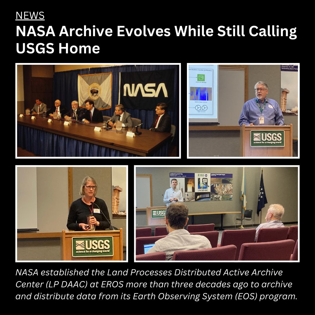
Did you know a @NASA archive calls EROS home? The #LPDAAC manages data from NASA sensors that monitor the Earth’s land surfaces from space. Learn more about the connections between EROS and its NASA archive partnership: ow.ly/E0Cv50UTtrh #EarthObservation #EarthData
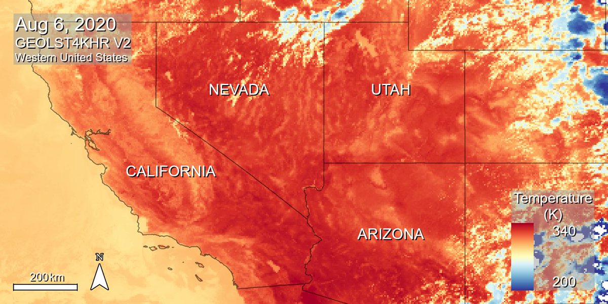
🚨 New Data Alert! 🚨 NASA’s #LPDAAC just added 7 more years of NASA MEaSUREs Geostationary Earth Orbit Land Surface Temperature (GEOLST4KHR) Version 2 data, covering 2017–2023! 🌍📊 Discover and access the updated dataset here: go.nasa.gov/4gDhCN2
New Data Alert! 🛰️ VIIRS BRDF/Albedo Version 2 Products are now available in the Application for Extracting and Exploring Analysis Ready Samples #AppEEARS. Visit the Data Alert released by NASA’s #LPDAAC to learn more: earthdata.nasa.gov/data/alerts-ou…

New capability! Subset GEDI Version 2 data products in NASA’s Earthdata Cloud using Earthdata Search and the Harmony API. This capability allows users to request spatial, temporal, and variable subsets of data. Learn more at NASA's #LPDAAC: go.nasa.gov/4dBzqGw

New Data Alert! 🛰️ VIIRS BRDF/Albedo Version 2 Products are now available in the Application for Extracting and Exploring Analysis Ready Samples #AppEEARS. Visit the Data Alert released by NASA’s #LPDAAC to learn more: earthdata.nasa.gov/data/alerts-ou…
GLanCE is growing! The Landsat-derived Global Land Cover Mapping and Estimation product now includes data over Oceania. Use a greenness index (EVI2) or explore seven land classes, as shown in this image over New Zealand. Learn more at NASA #LPDAAC: go.nasa.gov/3QCantD…
Did you know a @NASA archive calls EROS home? The #LPDAAC manages data from NASA sensors that monitor the Earth’s land surfaces from space. Learn more about the connections between EROS and its NASA archive partnership: ow.ly/E0Cv50UTtrh #EarthObservation #EarthData
Did you know a @NASA archive calls EROS home? The #LPDAAC manages data from NASA sensors that monitor the Earth’s land surfaces from space. Learn more about the connections between EROS and its NASA archive partnership: ow.ly/E0Cv50UTtrh #EarthObservation #EarthData

Now Available: NASA’s Land Processes DAAC (#LPDAAC) released VIIRS Version 2 Land Surface Phenology data products from the Suomi-NPP satellite. Learn more about the products and access data: go.nasa.gov/4auZBP2
NASA’s #LPDAAC and the ASTER Science Team @NASAJPL announced a final data processing campaign that will make the entire ASTER data archive freely available and easily accessible to users around the globe. ➡️Learn what this means for data users: go.nasa.gov/4ggJGoG
🚨 New Data Alert! 🚨 NASA’s #LPDAAC just added 7 more years of NASA MEaSUREs Geostationary Earth Orbit Land Surface Temperature (GEOLST4KHR) Version 2 data, covering 2017–2023! 🌍📊 Discover and access the updated dataset here: go.nasa.gov/4gDhCN2

Love the new ECOSTRESS products! 70 m soil moisture data is a game changer for my sustainability projects. Can't wait to dive in! #lpdaac #appeears
New ECOSTRESS products available! 70 m soil moisture, relative humidity, air temperature, net radiation 😮! lpdaac.usgs.gov/news/more-ecos… #lpdaac #appeears
New data! NASA’s #LPDAAC has released five new #Landsat-Derived Global Rainfed and Irrigated-Cropland Product (LGRIP) Version 2 datasets that map #agriculture for 2020 in the conterminous United States. * Global data to be added later* Access data: go.nasa.gov/4fXAmGI
New data! NASA’s #LPDAAC has released the Terra+Aqua Combined #MODIS Version 6.1 Bidirectional Reflectance Distribution Function (BRDF) and Albedo Gap-Filled Snow-Free Daily L3 Global 30ArcSec Climate Modelling Grid (CMG) data product. ➡️Access data: go.nasa.gov/3UXTDzL
Find webinars, tutorials, and video tips at NASA's #LPDAAC for accessing and working with land processes data from missions like EMIT, GEDI, and ECOSTRESS using a variety of software, web applications, custom tools, and scripts. ➡️Access resources: go.nasa.gov/4fpkvk8

Now Available: #VIIRS Version 2 Albedo, BRDF, and NBAR Tiled Data Products from the Suomi-NPP and NOAA-20 satellites. This image showcases a natural color composite of eastern North America from the VNP43MA4 product. ➡️Learn more at NASA's #LPDAAC : go.nasa.gov/48FFv3r
Now Available: #VIIRS Version 2 Albedo, BRDF, and NBAR Tiled Data Products from the Suomi-NPP and NOAA-20 satellites. This image showcases a natural color composite of eastern North America from the VNP43MA4 product. ➡️Learn more at NASA's #LPDAAC: go.nasa.gov/48FFv3r
NASA's Application for Extracting and Exploring Analysis Ready Samples (AρρEEARS) now provides a “Spectral Comparison” tab allowing visualization of point samples from the Earth Surface Mineral Dust Source Investigation (EMIT) mission. #LPDAAC Learn more: go.nasa.gov/4fswYTK
NASA’s Application for Extracting and Exploring Analysis Ready Samples #AppEEARS now supports point-and-area based data sampling requests for mineral data from the @NASAJPL EMIT mission! #LPDAAC #NASAEMIT Get started at: appeears.earthdatacloud.nasa.gov
NASA #LPDAAC's GEDI Version 2 Level 1B Geolocated Waveform, Level 2A Elevation and Height Metrics, and Level 2B Canopy Cover and Vertical Profile Metrics products are now available in the NASA Earthdata Cloud. Basemap: USAID NAIP 2020 Learn more: go.nasa.gov/4eNotT7
New Data! The 2005 epoch of the NASA #MEaSUREs Global Web-Enabled #Landsat Data (GWELD) Version 3.2 monthly and annual global 30-meter products are now available from NASA's #LPDAAC. For more information: go.nasa.gov/4eeDfC4
New capability! Subset GEDI Version 2 data products in NASA’s Earthdata Cloud using Earthdata Search and the Harmony API. This capability allows users to request spatial, temporal, and variable subsets of data. Learn more at NASA's #LPDAAC: go.nasa.gov/4dBzqGw
New #Python Tutorial! A new Jupyter Notebook tutorial developed by NASA's Land Processes DAAC (#LPDAAC) shows you how to work with NASA's EMIT L2B Estimated Mineral Identification and Band Depth and Uncertainty data. Access Notebook: go.nasa.gov/3WAVA6a
New data! NASA’s #LPDAAC has released five new #Landsat-Derived Global Rainfed and Irrigated-Cropland Product (LGRIP) Version 2 datasets that map #agriculture for 2020 in the conterminous United States. * Global data to be added later* Access data: go.nasa.gov/4fXAmGI
Attending the 2024 Ecological Society of America (#ESA2024) annual meeting? Register for the short course organized by NASA's #LPDAAC and #ORNLDAAC before July 18th, 2024 to learn how to work with GEDI #lidar data. ➡️Learn more: go.nasa.gov/3WmY9sE @GEDI_Knights

NASA’s #LPDAAC and the ASTER Science Team @NASAJPL announced a final data processing campaign that will make the entire ASTER data archive freely available and easily accessible to users around the globe. ➡️Learn what this means for data users: go.nasa.gov/4ggJGoG
NASA’s Application for Extracting and Exploring Analysis Ready Samples #AppEEARS now supports point-and-area based data sampling requests for mineral data from the @NASAJPL EMIT mission! #LPDAAC #NASAEMIT Get started at: appeears.earthdatacloud.nasa.gov
New #Python Tutorial! A new Jupyter Notebook tutorial developed by NASA's Land Processes DAAC (#LPDAAC) shows you how to work with NASA's EMIT L2B Estimated Mineral Identification and Band Depth and Uncertainty data. Access Notebook: go.nasa.gov/3WAVA6a
Now Available: #VIIRS Version 2 Albedo, BRDF, and NBAR Tiled Data Products from the Suomi-NPP and NOAA-20 satellites. This image showcases a natural color composite of eastern North America from the VNP43MA4 product. ➡️Learn more at NASA's #LPDAAC: go.nasa.gov/48FFv3r
New Data Alert! 🛰️ VIIRS BRDF/Albedo Version 2 Products are now available in the Application for Extracting and Exploring Analysis Ready Samples #AppEEARS. Visit the Data Alert released by NASA’s #LPDAAC to learn more: earthdata.nasa.gov/data/alerts-ou…
New data! NASA’s #LPDAAC has released the Terra+Aqua Combined #MODIS Version 6.1 Bidirectional Reflectance Distribution Function (BRDF) and Albedo Gap-Filled Snow-Free Daily L3 Global 30ArcSec Climate Modelling Grid (CMG) data product. ➡️Access data: go.nasa.gov/3UXTDzL
🚨 New Data Alert! 🚨 NASA’s #LPDAAC just added 7 more years of NASA MEaSUREs Geostationary Earth Orbit Land Surface Temperature (GEOLST4KHR) Version 2 data, covering 2017–2023! 🌍📊 Discover and access the updated dataset here: go.nasa.gov/4gDhCN2
Now Available: NASA’s Land Processes DAAC (#LPDAAC) released VIIRS Version 2 Land Surface Phenology data products from the Suomi-NPP satellite. Learn more about the products and access data: go.nasa.gov/4auZBP2
NASA #LPDAAC's GEDI Version 2 Level 1B Geolocated Waveform, Level 2A Elevation and Height Metrics, and Level 2B Canopy Cover and Vertical Profile Metrics products are now available in the NASA Earthdata Cloud. Basemap: USAID NAIP 2020 Learn more: go.nasa.gov/4eNotT7
New capability! Subset GEDI Version 2 data products in NASA’s Earthdata Cloud using Earthdata Search and the Harmony API. This capability allows users to request spatial, temporal, and variable subsets of data. Learn more at NASA's #LPDAAC: go.nasa.gov/4dBzqGw
Find webinars, tutorials, and video tips at NASA's #LPDAAC for accessing and working with land processes data from missions like EMIT, GEDI, and ECOSTRESS using a variety of software, web applications, custom tools, and scripts. ➡️Access resources: go.nasa.gov/4fpkvk8
GLanCE is growing! The Landsat-derived Global Land Cover Mapping and Estimation product now includes data over Oceania. Use a greenness index (EVI2) or explore seven land classes, as shown in this image over New Zealand. Learn more at NASA #LPDAAC: go.nasa.gov/3QCantD…
Are you looking for #CO2 #emission data? Check out the new EMIT Level-2B Carbon Dioxide Enhancement and Level-2B Estimated Carbon Dioxide Plume Complexes 60 m data products at NASA's #LPDAAC! #GHG Access the new products: go.nasa.gov/4cqlSgT
New Data! The 2005 epoch of the NASA #MEaSUREs Global Web-Enabled #Landsat Data (GWELD) Version 3.2 monthly and annual global 30-meter products are now available from NASA's #LPDAAC. For more information: go.nasa.gov/4eeDfC4
NASA's Application for Extracting and Exploring Analysis Ready Samples (AρρEEARS) now provides a “Spectral Comparison” tab allowing visualization of point samples from the Earth Surface Mineral Dust Source Investigation (EMIT) mission. #LPDAAC Learn more: go.nasa.gov/4fswYTK
New NASA Earth Surface Mineral Dust Source Investigation (EMIT) Level 4 Earth System Model Products (EMITL4ESM) Version 1 data available at NASA's #LPDAAC. Learn more about the products and access data: go.nasa.gov/3z1DVvf
Four new #GHG datasets are available at NASA's #LPDAAC. The new LPJ-EOSIM L2 Global Simulated Wetland #Methane Flux data products are available in daily and monthly temporal resolutions with high latency and low latency delivery schedules. Access data: go.nasa.gov/3xQHXGC
New ECOSTRESS products available! 70 m soil moisture, relative humidity, air temperature, net radiation 😮! lpdaac.usgs.gov/news/more-ecos… #lpdaac #appeears
Something went wrong.
Something went wrong.
United States Trends
- 1. #AEWDynamite 16.4K posts
- 2. #Survivor49 2,903 posts
- 3. Donovan Mitchell 3,585 posts
- 4. #CMAawards 3,416 posts
- 5. UConn 7,117 posts
- 6. #SistasOnBET 1,549 posts
- 7. Cavs 7,976 posts
- 8. Nick Allen 1,683 posts
- 9. #cma2025 N/A
- 10. Dubon 2,721 posts
- 11. Arizona 31.4K posts
- 12. Aaron Holiday N/A
- 13. Rockets 15.5K posts
- 14. Mobley 4,032 posts
- 15. Sengun 5,291 posts
- 16. Jaden Bradley N/A
- 17. Marquette 1,997 posts
- 18. Riho 2,598 posts
- 19. FEMA 45.3K posts
- 20. Savannah 4,473 posts