#nhwx resultados da pesquisa

A splash of color at sunrise this morning. Clouds will be spreading in, and rain showers and thunderstorms are expected to develop on Tuesday. Full details available at: mountwashington.org/weather/higher… #NHwx #NH #mountains #sunrise


At 4:45 PM EDT, 3 SSW Whitefield [Coos Co, NH] Utility Company reports Tstm Wnd Dmg. Trees and wires down on Gould road. #nhwx mesonet.agron.iastate.edu/lsr/?by=wfo&wf…
![NewEnglndIEMBot's tweet image. At 4:45 PM EDT, 3 SSW Whitefield [Coos Co, NH] Utility Company reports Tstm Wnd Dmg. Trees and wires down on Gould road. #nhwx mesonet.agron.iastate.edu/lsr/?by=wfo&wf…](https://pbs.twimg.com/media/HHmanFRXcAQJIs4.jpg)

5/4/2026 - Turning warmer today with wind. There will chances for thunderstorms Tuesday. Unsettled pattern develops Tuesday night with multiple chances for rainfall through Friday. weather.gov/gyx/weathersto… #NHWx #REadyNh #BePrepared

At 4:45 PM EDT, 1 S Whitefield [Coos Co, NH] Local Official reports Tstm Wnd Dmg. Trees and utility wires down. #nhwx mesonet.agron.iastate.edu/lsr/?by=wfo&wf…
![NewEnglndIEMBot's tweet image. At 4:45 PM EDT, 1 S Whitefield [Coos Co, NH] Local Official reports Tstm Wnd Dmg. Trees and utility wires down. #nhwx mesonet.agron.iastate.edu/lsr/?by=wfo&wf…](https://pbs.twimg.com/media/HHlgJLNXwAMAhhi.jpg)
Many locations may see their warmest day of 2026 so far today, but this will also set the stage for thunderstorms to develop this afternoon. Some storms may be strong to severe with potentially damaging wind being the main concern. Have ways to receive alerts today! #MEwx #NHwx
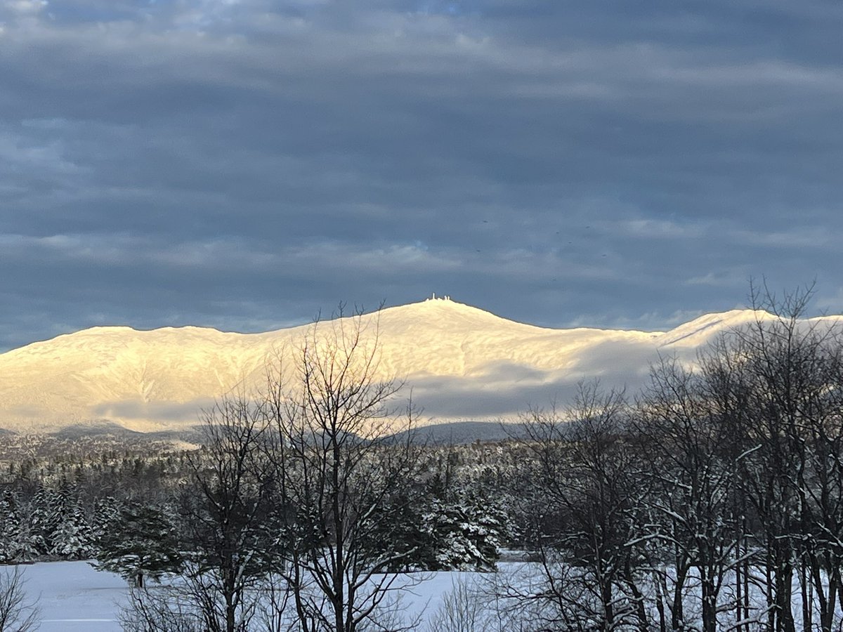
Winter hasn't released its grip on the White Mountains - this was our view this morning (1 May 2026). For a look at how this weekend is shaping up, our 48-hour Higher Summits Forecast is available at mountwashington.org/weather/higher… #NHwx #NH #Mountains #snow #snowinMay

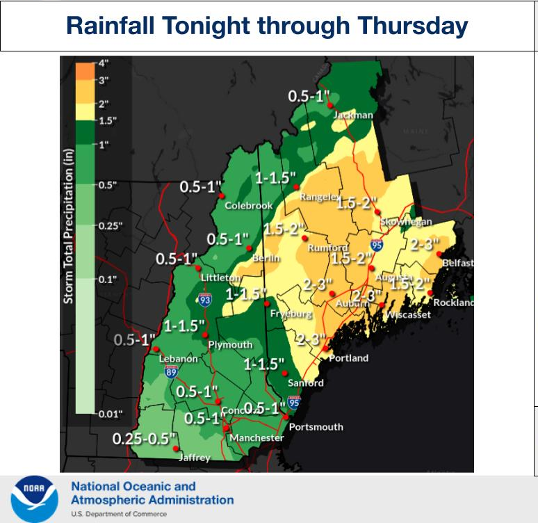
4/29/26 Cooler and cloudy along the coast with occasional drizzle and showers. Rain could be heavy at times tonight through Thursday, but flooding is not expected. Cool pattern prevails this weekend. weather.gov/gyx/EMhome #ReadyNH #NHwx #BePrepared

Good afternoon, showers and high-elevation snow showers are expected this weekend. Here's a look at how much snow we're expecting around Mount Washington. #NHwx #MEwx


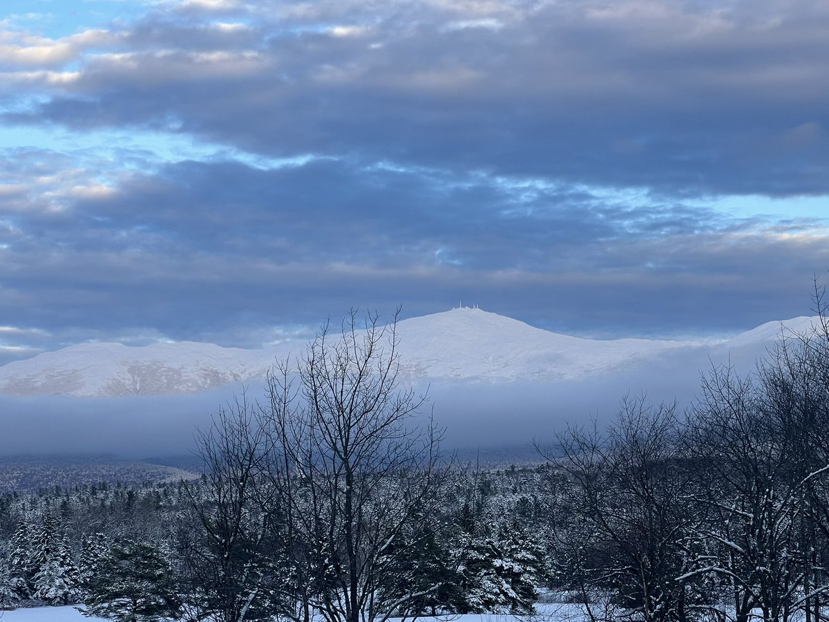
Looking down the eastern slopes of Mt Washington towards Nelson Crag and the Alpine Garden this morning. #NHwx #NH #Mountains #sunrise #snow


NH *FIRE WEATHER DANGER* The Statewide predicted fire danger for today is a Class 2 (MODERATE), permits are required where burning is allowed - 4/21 #NHForestry #NHWX #NHFireDanger #Rockingham #NHReady #NHSafe


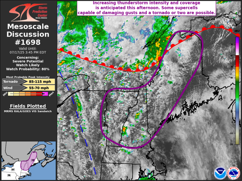
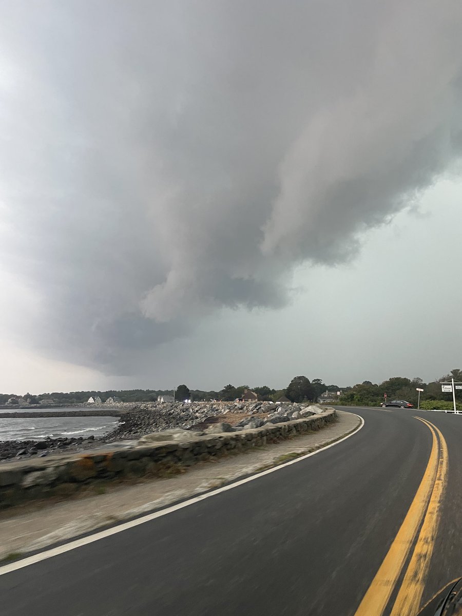
A watch is likely coming in northern New England. A few tornadoes are possible, particularly near the international border from northern Vermont to northern Maine. #MEwx #NHwx #VTwx
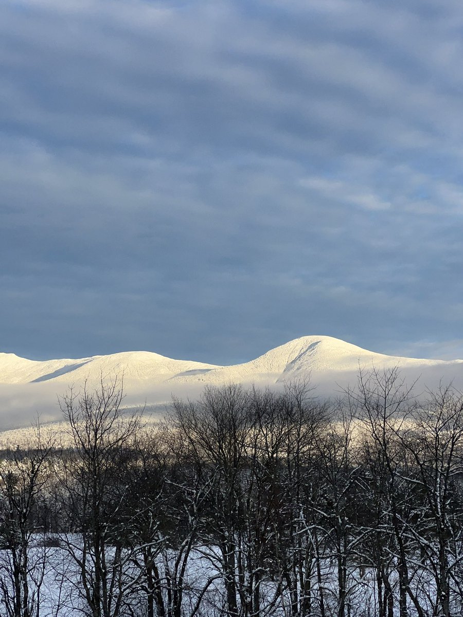
And just like that Mt. Washington decided to pop out from behind the clouds for a little bit! Just stunning! #nhwx


At 4:45 PM EDT, 3 SSW Whitefield [Coos Co, NH] Utility Company reports Tstm Wnd Dmg. Trees and wires down on Gould road. #nhwx mesonet.agron.iastate.edu/lsr/?by=wfo&wf…

At 4:45 PM EDT, 3 SSW Whitefield [Coos Co, NH] Utility Company reports Tstm Wnd Dmg. Trees and wires down on Gould road. #nhwx mesonet.agron.iastate.edu/lsr/?by=wfo&wf…
![iembot_gyx's tweet image. At 4:45 PM EDT, 3 SSW Whitefield [Coos Co, NH] Utility Company reports Tstm Wnd Dmg. Trees and wires down on Gould road. #nhwx mesonet.agron.iastate.edu/lsr/?by=wfo&wf…](https://pbs.twimg.com/media/HHmanE9XEAYfzg4.jpg)
At 4:45 PM EDT, 1 S Whitefield [Coos Co, NH] Local Official reports Tstm Wnd Dmg. Trees and utility wires down. #nhwx mesonet.agron.iastate.edu/lsr/?by=wfo&wf…
At 4:45 PM EDT, 1 S Whitefield [Coos Co, NH] Local Official reports Tstm Wnd Dmg. Trees and utility wires down. #nhwx mesonet.agron.iastate.edu/lsr/?by=wfo&wf…
![iembot_gyx's tweet image. At 4:45 PM EDT, 1 S Whitefield [Coos Co, NH] Local Official reports Tstm Wnd Dmg. Trees and utility wires down. #nhwx mesonet.agron.iastate.edu/lsr/?by=wfo&wf…](https://pbs.twimg.com/media/HHlgJLRXgAMi9jH.jpg)

A line of storms have begun to fire across northern & westernmost New England. A severe thunderstorm warning is in effect for northern Maine. #NHwx #MEwx #VTwx

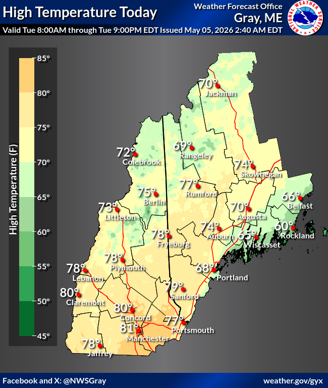
5/5/26 - Temperatures may creep into the 80s across southern New Hampshire. There may be strong to severe thunderstorms this afternoon with damaging winds. Wednesday through Thursday will see rain. weather.gov/gyx/weathersto… #NHWx #ReadyNH #BePrepared

A splash of color at sunrise this morning. Clouds will be spreading in, and rain showers and thunderstorms are expected to develop on Tuesday. Full details available at: mountwashington.org/weather/higher… #NHwx #NH #mountains #sunrise
Many locations may see their warmest day of 2026 so far today, but this will also set the stage for thunderstorms to develop this afternoon. Some storms may be strong to severe with potentially damaging wind being the main concern. Have ways to receive alerts today! #MEwx #NHwx
5/4/2026 - Turning warmer today with wind. There will chances for thunderstorms Tuesday. Unsettled pattern develops Tuesday night with multiple chances for rainfall through Friday. weather.gov/gyx/weathersto… #NHWx #REadyNh #BePrepared

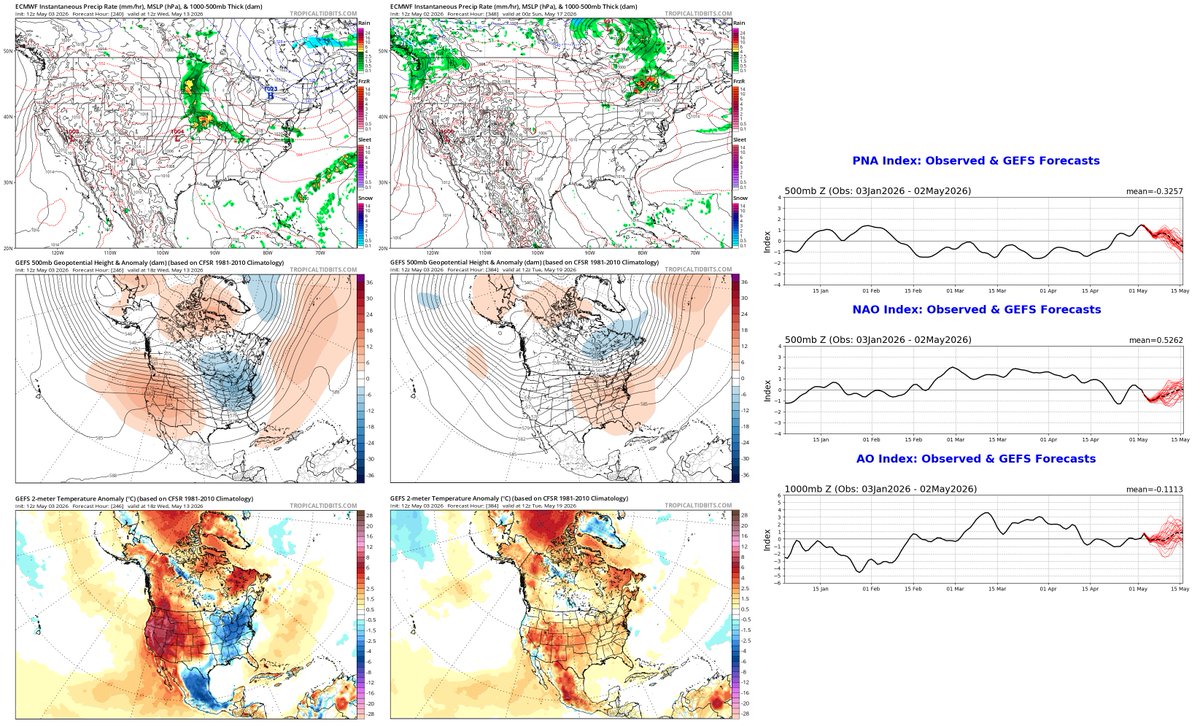
"Dirty" brief warmup thru Tue w/ clouds, showers in N New England/SE Canada; cool rest of week, maybe heavy rain SE of St. Lawrence Valley Wed-Fri; drier, still cool next weekend, then maybe gradual warmup mid-May. #nywx #vtwx #nhwx #mewx #onstorm #qcstorm nnesecawxyjl.blogspot.com/2026/05/dirty-…

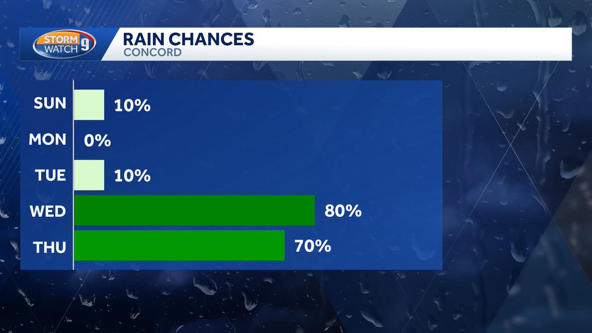
Happy Sunday! We'll see a quick break from the gloomy weather tomorrow and Tuesday before more showery conditions arrive at the end of the week. Here's a look at what we are expecting for temperatures, sky cover and rain chances. #NHwx #MEwx


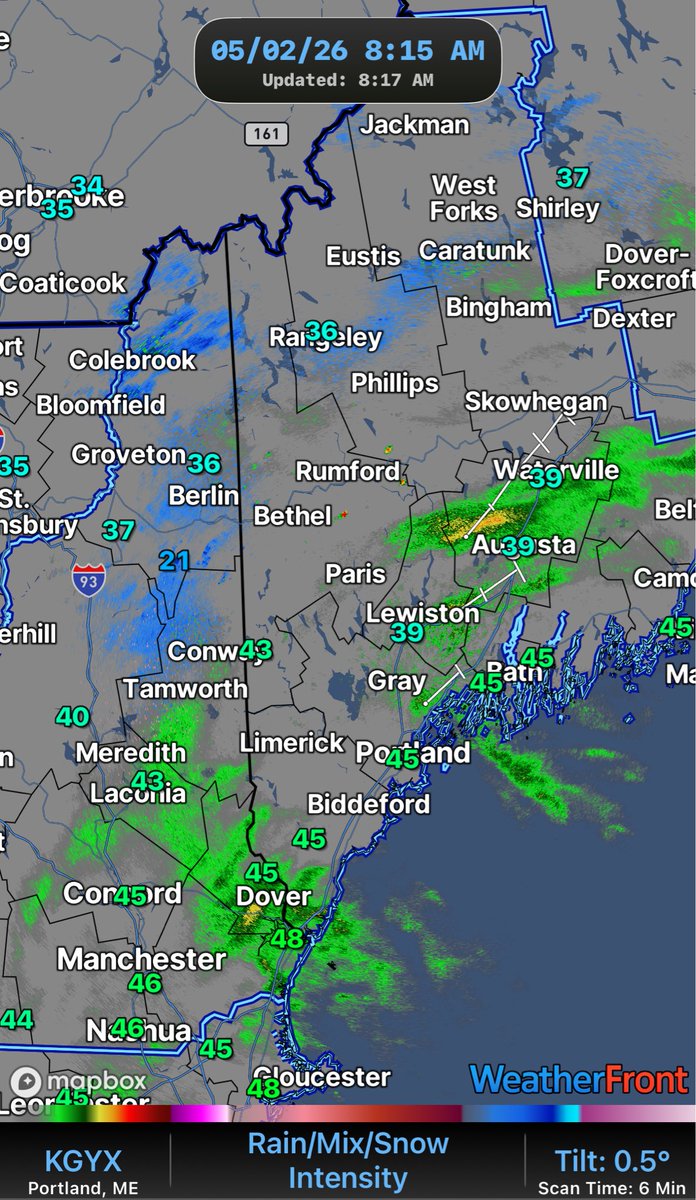
Aside from a spotty shower, a mainly dry day ahead Sunday as a system misses us to the east with steady rain through the Gulf of Maine. We see a warming trend to start the week and a few showers north, then a better shot at more beneficial/widespread rain by midweek. #NHwx #rain

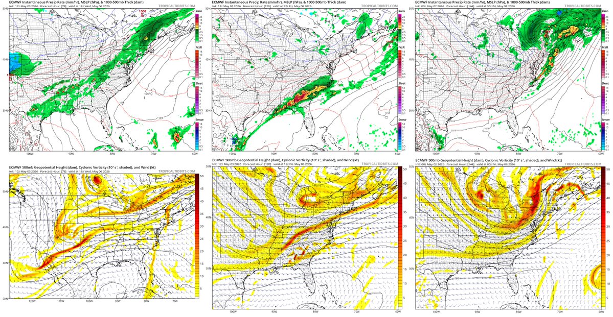
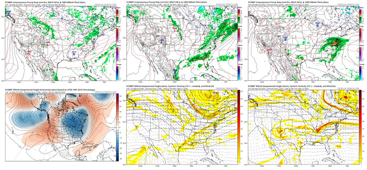
Looking ahead to late next week (May 8-9) — we are keeping an eye on potential coastal cyclogenesis that could bring heavy rain or even wet snow to New England (MA, NH). Still days away, but the pattern is unusually cold for May. #MAwx #NHwx


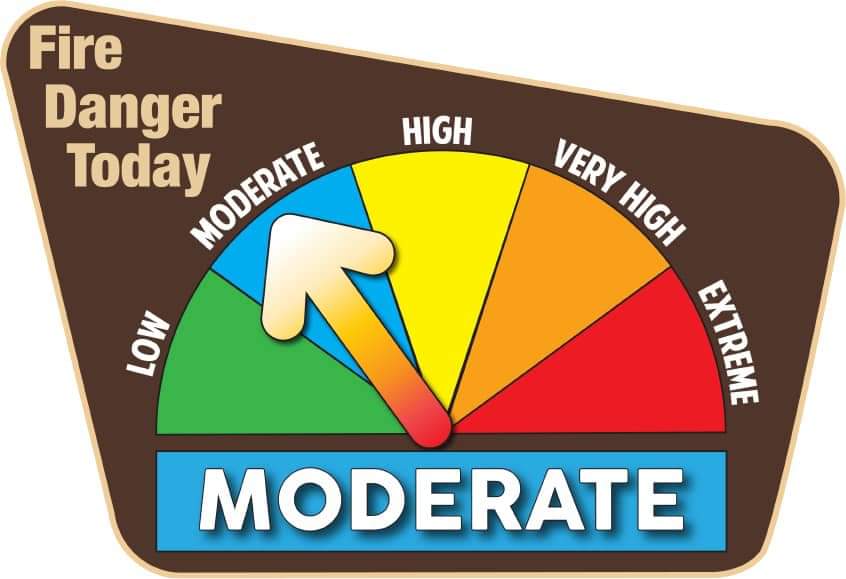
NH *FIRE WEATHER DANGER* The Statewide predicted fire danger for today is a Class 2 (MODERATE), permits are required where burning is allowed - 5/1 #NHFireDanger #NHWX #NHForestry ##NHSafe #NHReady #Rockingham
Good afternoon, showers and high-elevation snow showers are expected this weekend. Here's a look at how much snow we're expecting around Mount Washington. #NHwx #MEwx
...Maine and New Hampshire Severe Weather Awareness Week... Make a severe weather plan before you need it! Your family may not be together when a disaster strikes so it is important to plan in advance. To find out how, visit ready.gov/make-a-plan #mewx #nhwx


5/4/2026 - Turning warmer today with wind. There will chances for thunderstorms Tuesday. Unsettled pattern develops Tuesday night with multiple chances for rainfall through Friday. weather.gov/gyx/weathersto… #NHWx #REadyNh #BePrepared
A splash of color at sunrise this morning. Clouds will be spreading in, and rain showers and thunderstorms are expected to develop on Tuesday. Full details available at: mountwashington.org/weather/higher… #NHwx #NH #mountains #sunrise
At 4:45 PM EDT, 1 S Whitefield [Coos Co, NH] Local Official reports Tstm Wnd Dmg. Trees and utility wires down. #nhwx mesonet.agron.iastate.edu/lsr/?by=wfo&wf…
A line of storms have begun to fire across northern & westernmost New England. A severe thunderstorm warning is in effect for northern Maine. #NHwx #MEwx #VTwx
Many locations may see their warmest day of 2026 so far today, but this will also set the stage for thunderstorms to develop this afternoon. Some storms may be strong to severe with potentially damaging wind being the main concern. Have ways to receive alerts today! #MEwx #NHwx
At 4:45 PM EDT, 1 S Whitefield [Coos Co, NH] Local Official reports Tstm Wnd Dmg. Trees and utility wires down. #nhwx mesonet.agron.iastate.edu/lsr/?by=wfo&wf…
At 4:45 PM EDT, 3 SSW Whitefield [Coos Co, NH] Utility Company reports Tstm Wnd Dmg. Trees and wires down on Gould road. #nhwx mesonet.agron.iastate.edu/lsr/?by=wfo&wf…
At 4:45 PM EDT, 3 SSW Whitefield [Coos Co, NH] Utility Company reports Tstm Wnd Dmg. Trees and wires down on Gould road. #nhwx mesonet.agron.iastate.edu/lsr/?by=wfo&wf…
5/5/26 - Temperatures may creep into the 80s across southern New Hampshire. There may be strong to severe thunderstorms this afternoon with damaging winds. Wednesday through Thursday will see rain. weather.gov/gyx/weathersto… #NHWx #ReadyNH #BePrepared


And just like that Mt. Washington decided to pop out from behind the clouds for a little bit! Just stunning! #nhwx
NH *FIRE WEATHER DANGER* The Statewide predicted fire danger for today is a Class 2 (MODERATE), permits are required where burning is allowed - 5/1 #NHFireDanger #NHWX #NHForestry ##NHSafe #NHReady #Rockingham
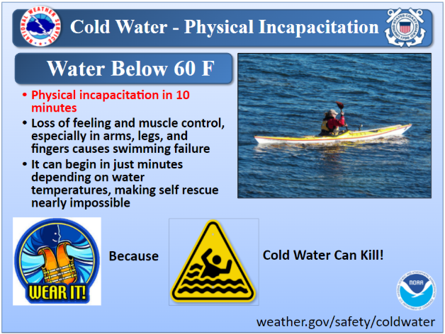
Today’s Topic: Physical Incapacitation Physical incapacitation is when you’ve become physically helpless in the water because you can no longer control your arms, legs, hands and feet. t.ly/jeWm #mewx #nhwx


Something went wrong.
Something went wrong.
United States Trends
- 1. Austin Reaves N/A
- 2. #DaredevilBornAgain N/A
- 3. Luka N/A
- 4. Shai N/A
- 5. Vivek N/A
- 6. Jared McCain N/A
- 7. Matt Olson N/A
- 8. Indiana N/A
- 9. Thunder N/A
- 10. Fisk N/A
- 11. Boldy N/A
- 12. Logan Webb N/A
- 13. Laravia N/A
- 14. #LakeShow N/A
- 15. #WWENXT N/A
- 16. #Lakers N/A
- 17. Vando N/A
- 18. #GoAvsGo N/A
- 19. Harden N/A
- 20. Ohio N/A