#repmo arama sonuçları

Strong to severe storms around 10pm tonight according to the #hrrr model. Lightning and damaging wind gusts are the main threats. #SGF #repmo #nixa #ozark #mountVernon #willard #fairGrove #mowx

Severe storms coming between 3pm-5pm today. All hazards possible. Watch for isolated cells or bowing segments for strong tornado potential. Expect a tornado watch soon as well. #repmo #SGF #ozark #nixa #mountVernon #fairGrove #marshfield #rogersville #clever #mowx
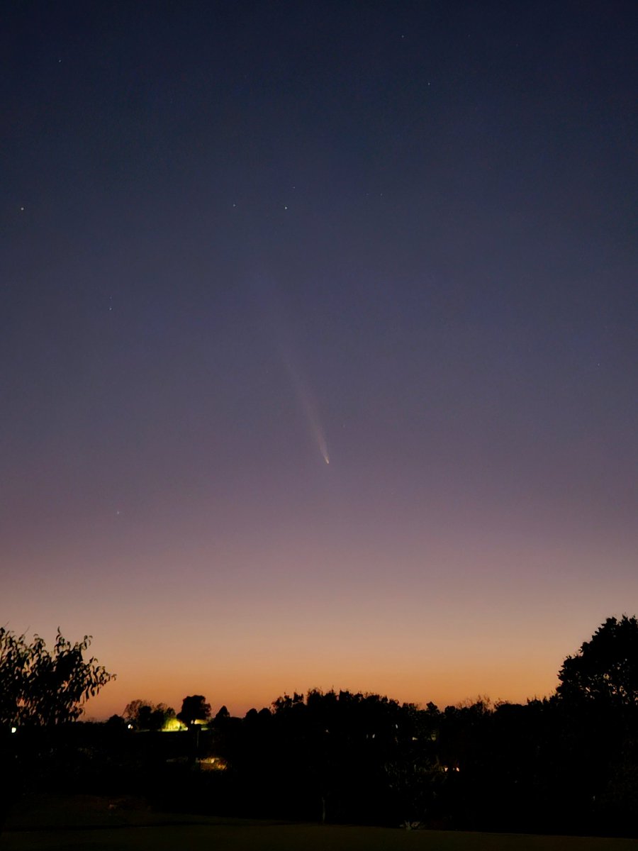
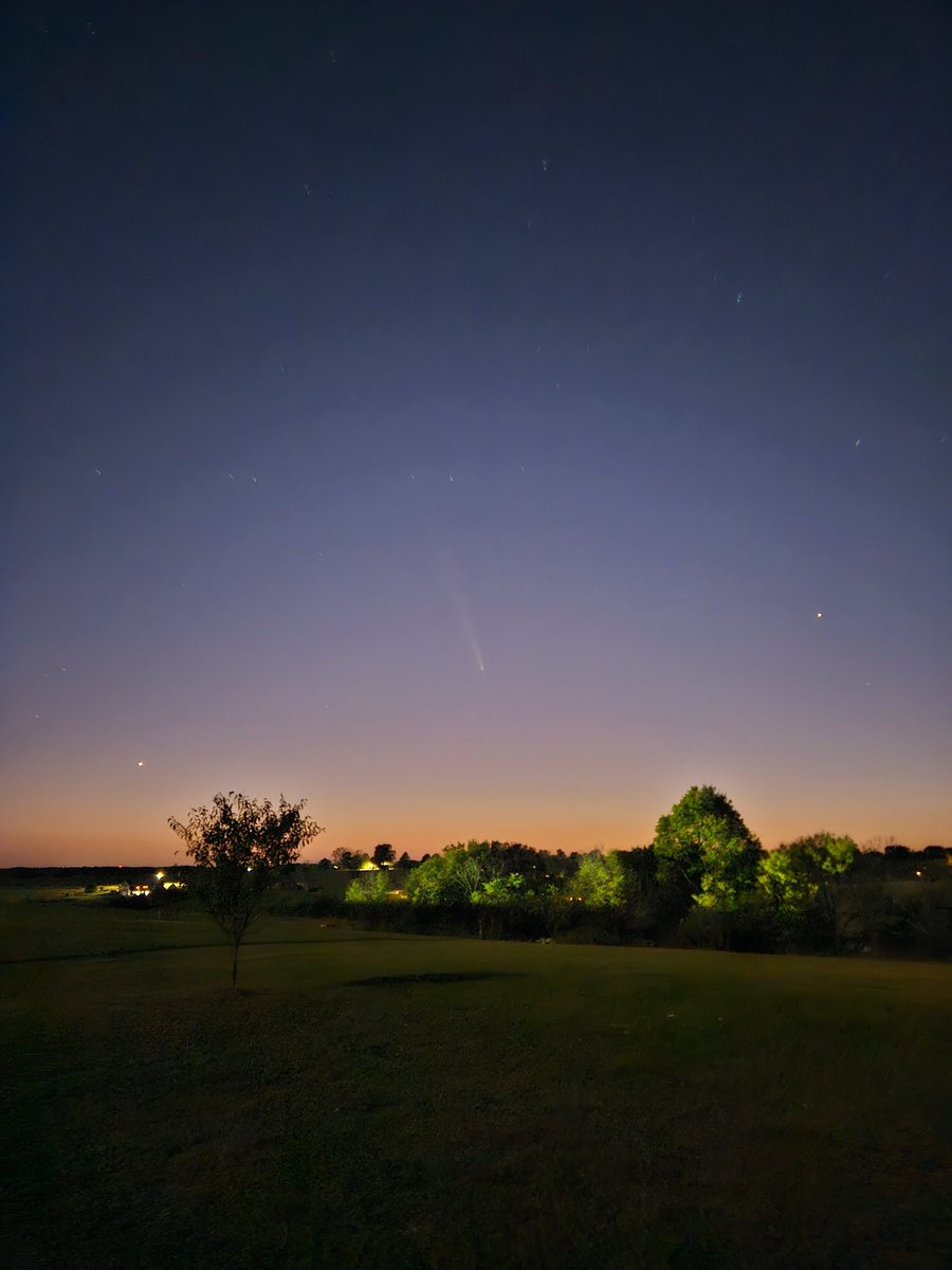
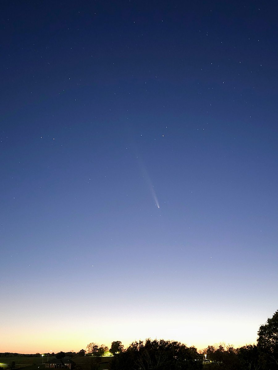
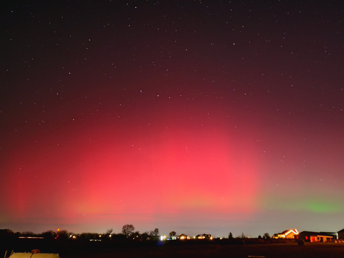
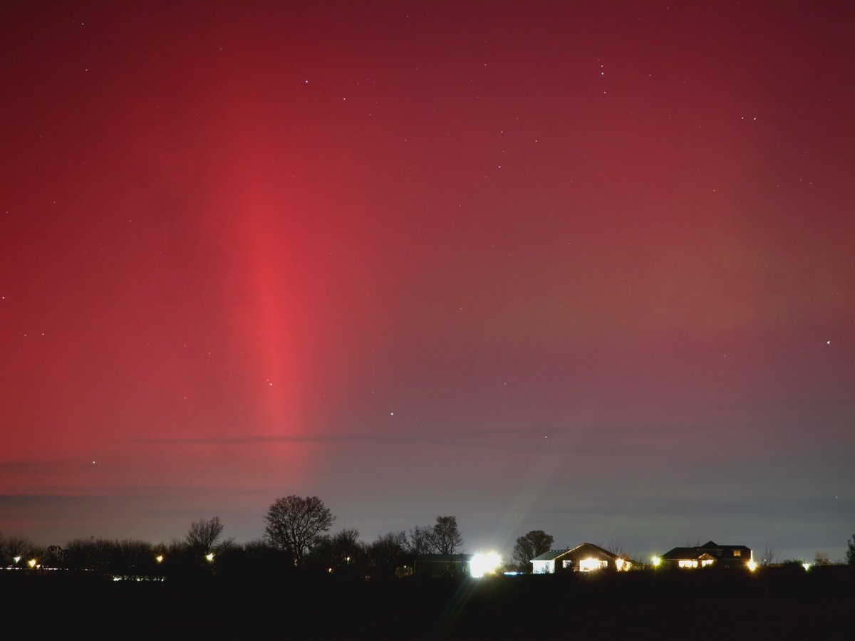
Comet C/2023 A3 (Tsuchinshan-ATLAS) from #repmo. You can see it with naked eye, but these are 3 second photos. This was approximately 45 minutes after sunset. #mowx #comet

Max wind gust in #repmo was 35.1mph around 4:30pm. Expect wind gusts to continue tomorrow, and please DO NOT BURN outdoors. #SGF #nixa #ozark #mountVernon #willard #fairGrove #mowx


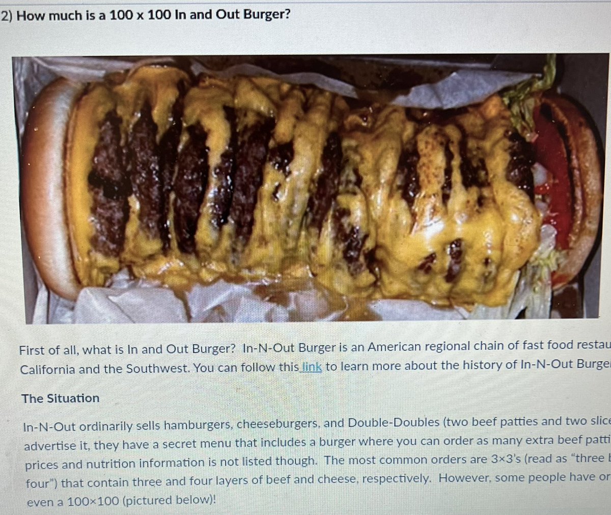
Today is one of my favorite lessons of the year. How much is a 100 x100 burger from In and Out Burger? An oldie but a goodie. The kids work so hard to figure this out. #math #middleschoolmath #repmo #repmoproud #rmsrocks
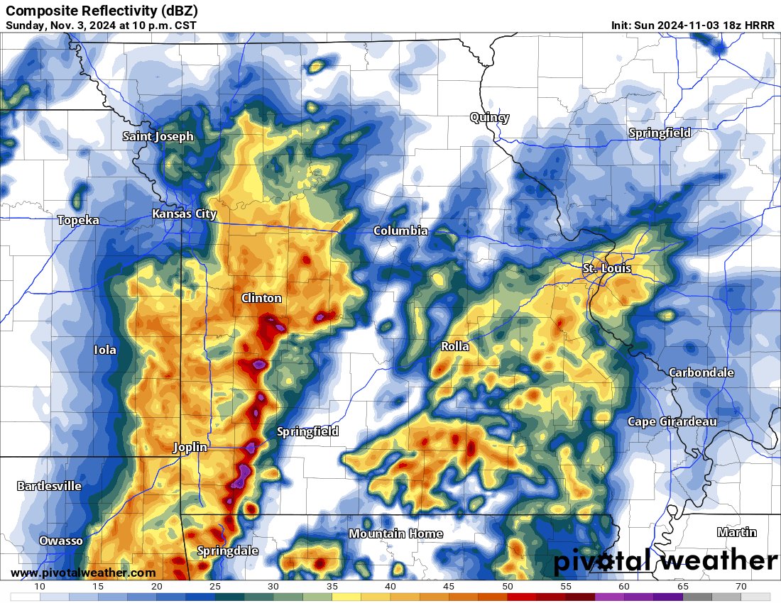
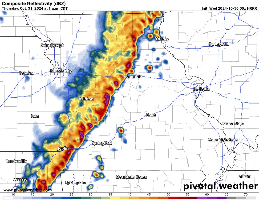
A cold front is coming in a little over 24 hours from now. Along with that, severe storms are likely ahead of it. #hrrr showing storms just after 1am Thursday morning. #repmo #SGF #ozark #nixa #mountVernon #fairGrove #willard @HRRRing #nowx


Severe storms likely between 4pm-6pm this evening with all modes of severe weather possible. Storms will become more severe east of US65 corridor. #repmo #SGF #nixa #ozark #mountVernon #willard #rogersville #clever #fairGrove #mowx

Severe storms tonight are pretty much a lock at this point. Two rounds and all hazards are on the table. Expect a tornado watch to be issued in a few hours. #repmo #SGF #nixa #ozark #willard #rogersville #fairGrove #mountVernon #mowx
Year 31 is underway. Thousands of students Hundreds of colleagues 13 lead principals 19 assistant principals 9 superintendents 29 years at the same grade level and school district. #rmsrocks #republicmiddle #repmo #math #6thgrade
Slight risk of severe storms tonight. Hail and damaging winds, along with Lightning, are the threats. #repmo #mountVernon #nixa #ozark #clever #willard #fairGrove #rogersville #mowx
@NWSSPC has identified our area as potential for severe weather on Friday and into Saturday morning for a giant warm sector. Have to watch this area this week to see how it processes. #repmo #SGF #willard #mountVernon #clever #nixa #ozark #mowx

Day 3 of #RepMo parks camps…hitting day today! @Coach_Hooper1 @CoachAlKelly15 @connor_sechler @The_19_Kid @Clubhouse_mw
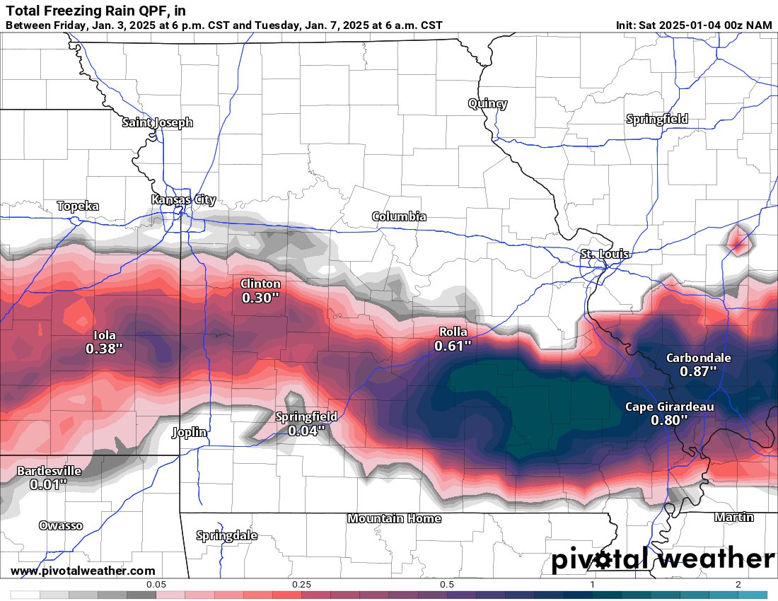
Models are starting to come together on the winter storm this weekend. All types of precipitation possible. Right now, #SGF area barely misses heavy freezing rain swath. This all could change the closer we get, depending on the exact low pressure track. #repmo #nixa #ozark #mowx

60.8mph wind gust in #repmo a few minutes ago. Station is in a wide open field. @NWSSpringfield #repmo #mowx

This is the area to watch. Notice the clear satellite view west of the dryline. The other contours show is CAPE value or measurement of instability. It is lower to the east because of the clouds and rain today and is only marginally unstable. #SGF #repmo #nixa #ozark #mowx


Good start to the season at the plate, trying to hit the first couple of pitches in my at bats. #baseball #Repmo #uncommitted


@PottsReid planning on catching some passes from you tomorrow but we’re not friends tonight #RepMo>nixa

#RepMo Hwy 60 loop between Git N Go and Pat's Pizza. Burned many a gallon there, although back then it only costs around $0.85/gallon

Severe storms coming between 3pm-5pm today. All hazards possible. Watch for isolated cells or bowing segments for strong tornado potential. Expect a tornado watch soon as well. #repmo #SGF #ozark #nixa #mountVernon #fairGrove #marshfield #rogersville #clever #mowx

Excited to be in Rolla, MO today for my visit to MO S&T! Can’t wait to see what the Miners are about. Big thanks to @CoachOeser for the invite! Let’s get to work!#PickAxeTakeNames⛏️@Miners_FB @minersports @coachball_FB @RepMoTigersFB #RepMo #JuniorDay #NextLevel

Track season just started! Every rep in the ring is making me stronger for football. #RepMo #TrackSeason #ShotPut #FootballGrind #StrongerEveryDay #NoOffSeason #DualAthlete

Slight risk of severe storms tonight. Hail and damaging winds, along with Lightning, are the threats. #repmo #mountVernon #nixa #ozark #clever #willard #fairGrove #rogersville #mowx
60.8mph wind gust in #repmo a few minutes ago. Station is in a wide open field. @NWSSpringfield #repmo #mowx
Still locked in! My junior season was unforgettable. Got more to prove. Check out my highlights if you haven’t yet! #REPMO #BeTheStandard #NextLevel hudl.com/v/2R9Leb

Severe storms likely between 4pm-6pm this evening with all modes of severe weather possible. Storms will become more severe east of US65 corridor. #repmo #SGF #nixa #ozark #mountVernon #willard #rogersville #clever #fairGrove #mowx
@NWSSPC has identified our area as potential for severe weather on Friday and into Saturday morning for a giant warm sector. Have to watch this area this week to see how it processes. #repmo #SGF #willard #mountVernon #clever #nixa #ozark #mowx

The boys finish 7th and the girls 8th at the Hickman Tournament. Congratulations to our medalists! #repmowrestling #repmo #repmotigers


Strong to severe storms around 10pm tonight according to the #hrrr model. Lightning and damaging wind gusts are the main threats. #SGF #repmo #nixa #ozark #mountVernon #willard #fairGrove #mowx
Severe storms coming between 3pm-5pm today. All hazards possible. Watch for isolated cells or bowing segments for strong tornado potential. Expect a tornado watch soon as well. #repmo #SGF #ozark #nixa #mountVernon #fairGrove #marshfield #rogersville #clever #mowx
Max wind gust in #repmo was 35.1mph around 4:30pm. Expect wind gusts to continue tomorrow, and please DO NOT BURN outdoors. #SGF #nixa #ozark #mountVernon #willard #fairGrove #mowx
Comet C/2023 A3 (Tsuchinshan-ATLAS) from #repmo. You can see it with naked eye, but these are 3 second photos. This was approximately 45 minutes after sunset. #mowx #comet
This is the area to watch. Notice the clear satellite view west of the dryline. The other contours show is CAPE value or measurement of instability. It is lower to the east because of the clouds and rain today and is only marginally unstable. #SGF #repmo #nixa #ozark #mowx
Severe storms tonight are pretty much a lock at this point. Two rounds and all hazards are on the table. Expect a tornado watch to be issued in a few hours. #repmo #SGF #nixa #ozark #willard #rogersville #fairGrove #mountVernon #mowx
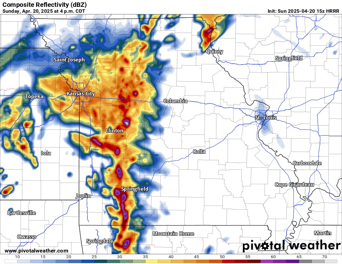
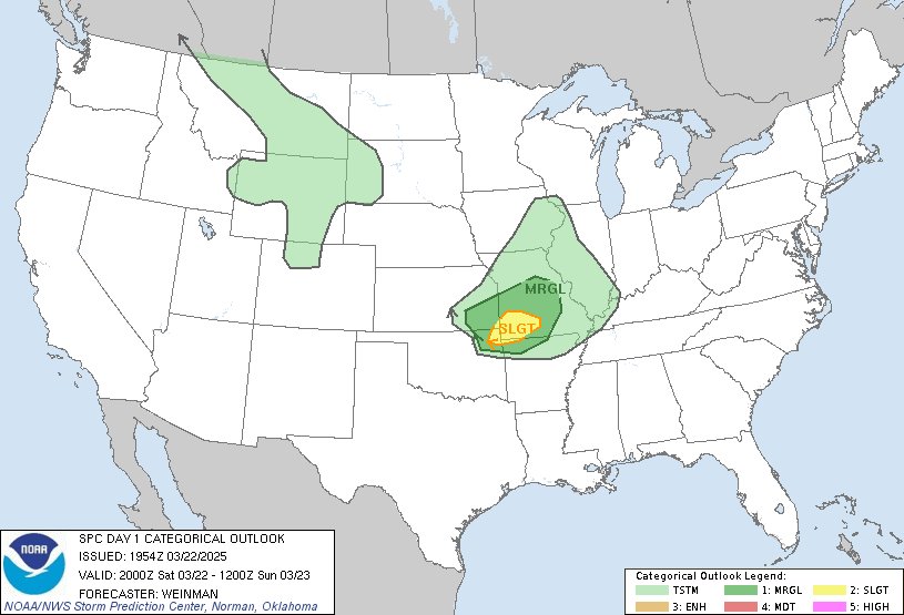
Today is one of those days that you need to pay closer attention to the weather. ALL modes of severe weather are possible, including strong tornadoes. Warm front lifts and puts us in the warm sector early this afternoon. #SGF #repmo #ozark #nixa #willard #mowx


Severe storms likely between 4pm-6pm this evening with all modes of severe weather possible. Storms will become more severe east of US65 corridor. #repmo #SGF #nixa #ozark #mountVernon #willard #rogersville #clever #fairGrove #mowx
A cold front is coming in a little over 24 hours from now. Along with that, severe storms are likely ahead of it. #hrrr showing storms just after 1am Thursday morning. #repmo #SGF #ozark #nixa #mountVernon #fairGrove #willard @HRRRing #nowx

Slight risk of severe storms tonight. Hail and damaging winds, along with Lightning, are the threats. #repmo #mountVernon #nixa #ozark #clever #willard #fairGrove #rogersville #mowx
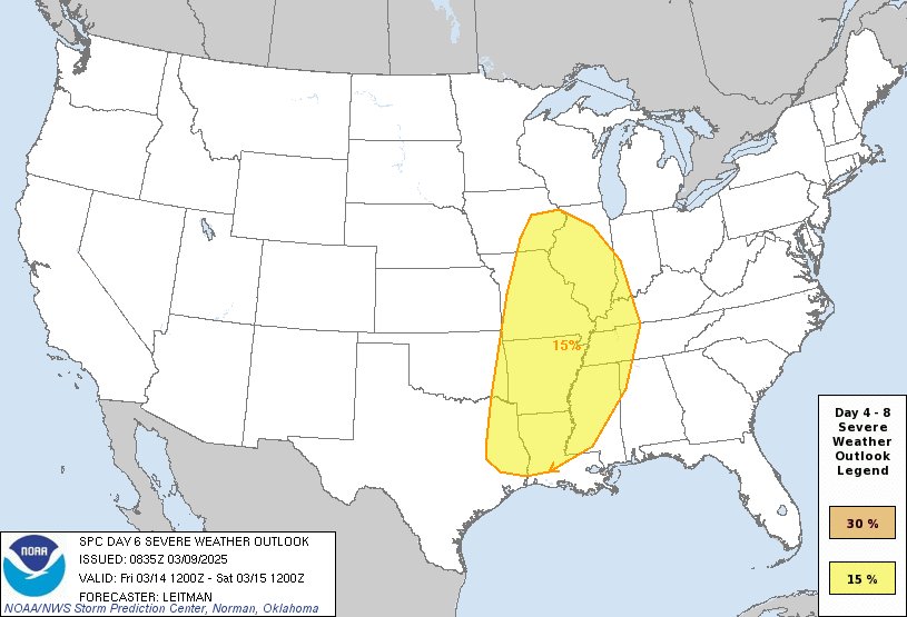
Models are starting to come together on the winter storm this weekend. All types of precipitation possible. Right now, #SGF area barely misses heavy freezing rain swath. This all could change the closer we get, depending on the exact low pressure track. #repmo #nixa #ozark #mowx
Something went wrong.
Something went wrong.
United States Trends
- 1. Jokic N/A
- 2. Knicks N/A
- 3. Tony Brothers N/A
- 4. #WWERaw N/A
- 5. Brunson N/A
- 6. Mike Brown N/A
- 7. CJ McCollum N/A
- 8. Nuggets N/A
- 9. Nuggets N/A
- 10. Rudy Gobert N/A
- 11. Hawks N/A
- 12. #TexasHockey N/A
- 13. Christian Braun N/A
- 14. Mikal Bridges N/A
- 15. Aaron Gordon N/A
- 16. #bucciovertimechallenge N/A
- 17. Donte N/A
- 18. Foligno N/A
- 19. Naz Reid N/A
- 20. Anthony Edwards N/A