#simmsa hasil pencarian

#IIGEA #SIMMSA #SISMO #EARTHQUAKE MAGNITUDE: 5.2Mw #ASCENSION #ISLAND #REGION 2026-01-20, 06:04:14.61 UTC LAT: -10.2866° LON: -13.0795° DEPTH: -12.0km iigea.org/monitor

#IIGEA #SIMMSA #SISMO #EARTHQUAKE MAGNITUDE: 5.1Mw #VOLCANO #ISLANDS #JAPAN #REGION 2026-01-21, 04:04:20.24 UTC LAT: 24.669° LON: 141.491° DEPTH: -10.0km iigea.org/monitor

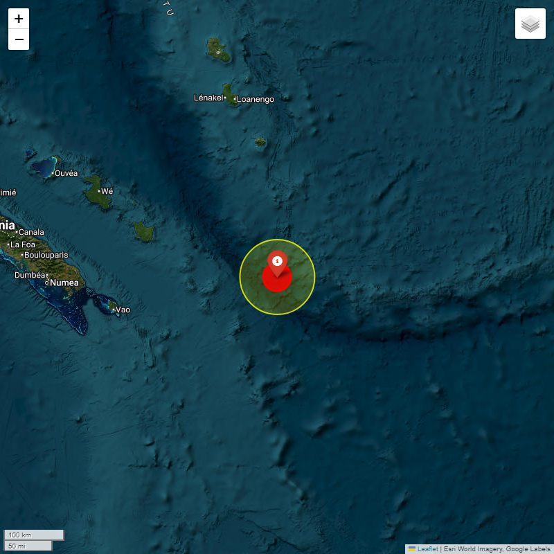
#IIGEA #SIMMSA #SISMO #EARTHQUAKE MAGNITUDE: 5.1Mw #SOUTHEAST #LOYALTY #ISLANDS 2026-01-20, 23:29:59.92 UTC LAT: -22.187° LON: 170.095° DEPTH: -10.0km iigea.org/monitor

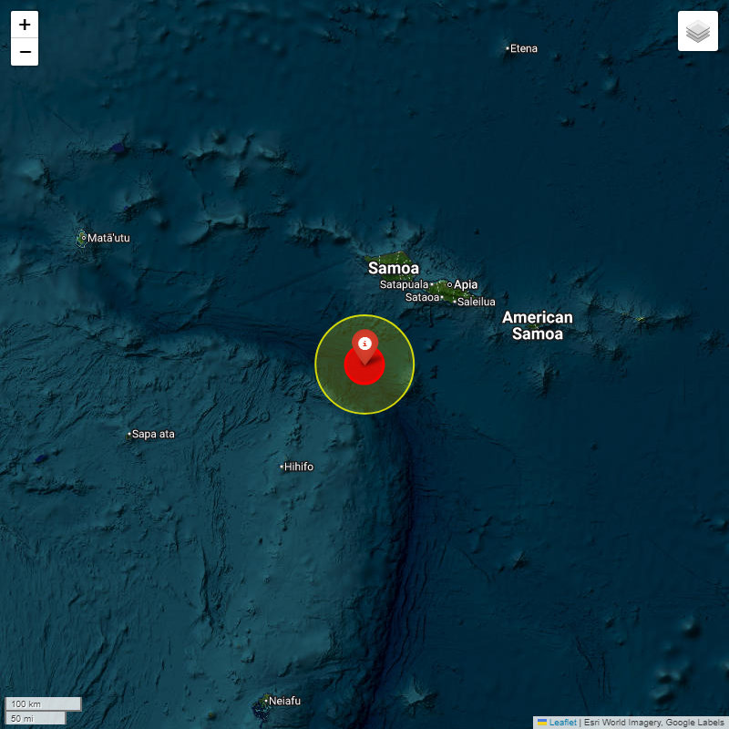
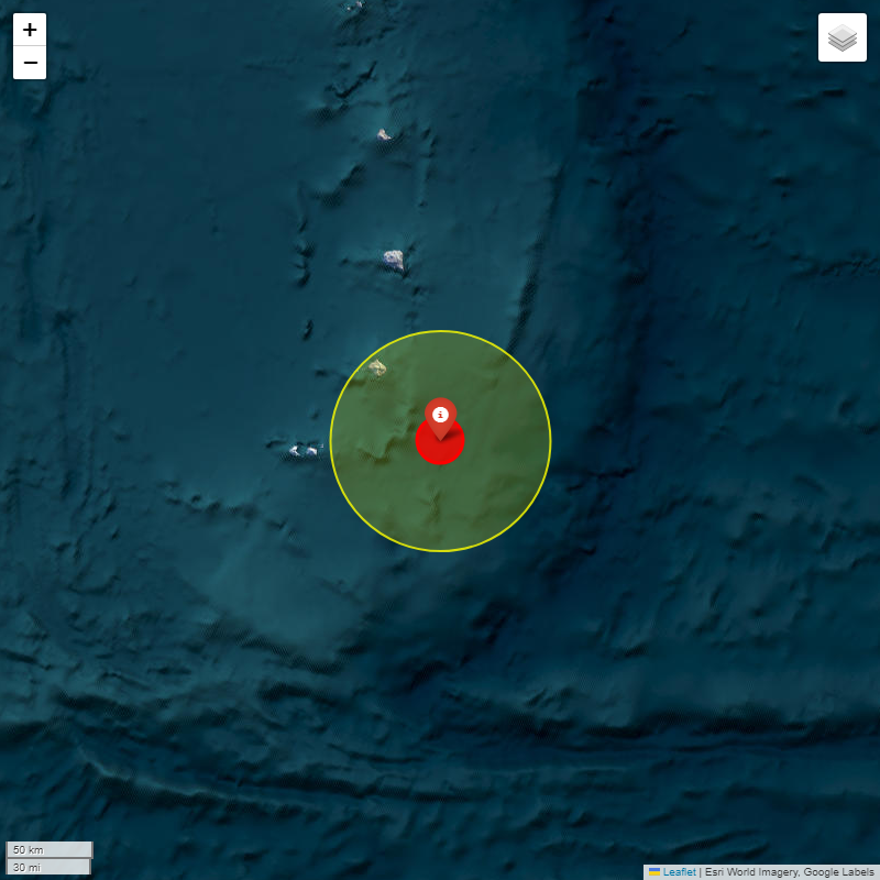
#IIGEA #SIMMSA #SISMO #EARTHQUAKE MAGNITUDE: 5.3Mw #SAMOA #ISLANDS 2026-01-20, 05:38:53.96 UTC LAT: -14.7633° LON: -172.7908° DEPTH: -29.0km iigea.org/monitor

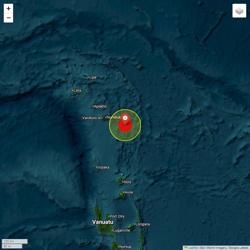
#IIGEA #SIMMSA #SISMO #EARTHQUAKE MAGNITUDE: 5.0Mw #SANTA #CRUZ #ISLANDS 2026-01-20, 08:18:09.32 UTC LAT: -11.925° LON: 167.633° DEPTH: -55.3km iigea.org/monitor

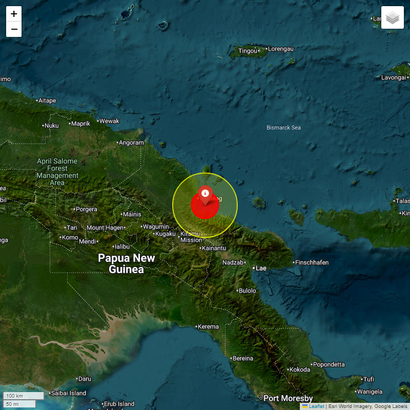
#IIGEA #SIMMSA #SISMO #EARTHQUAKE MAGNITUDE: 6.4Mw #EASTERN #NEW #GUINEA #REG #P.N.G 2026-01-20, 07:21:59.18 UTC LAT: -5.3797° LON: 145.9528° DEPTH: -78.0km iigea.org/monitor
#IIGEA #SIMMSA #SISMO #EARTHQUAKE MAGNITUDE: 5.1Mw #CARLSBERG #RIDGE 2026-01-20, 11:14:43.81 UTC LAT: 4.3529° LON: 62.5102° DEPTH: -16.0km iigea.org/monitor
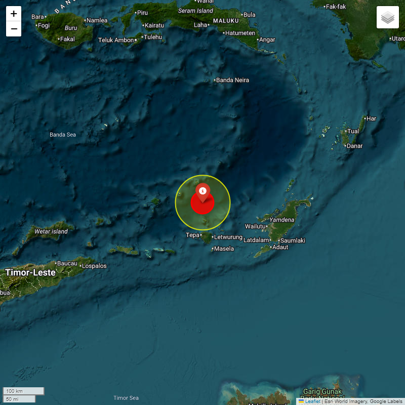
#IIGEA #SIMMSA #SISMO #EARTHQUAKE MAGNITUDE: 5.5Mw #KEPULAUAN #BABAR #INDONESIA 2026-01-21, 05:49:36.76 UTC LAT: -7.17° LON: 129.644° DEPTH: -86.2km iigea.org/monitor

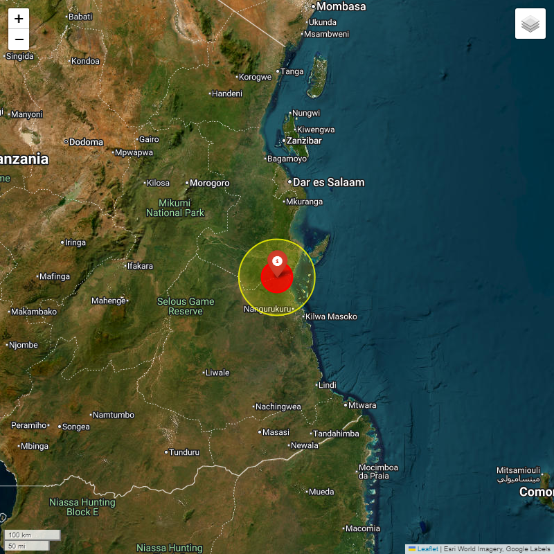
#IIGEA #SIMMSA #SISMO #EARTHQUAKE MAGNITUDE: 5.5Mw #TANZANIA 2026-01-20, 17:11:39.97 UTC LAT: -8.313° LON: 39.087° DEPTH: -10.0km iigea.org/monitor
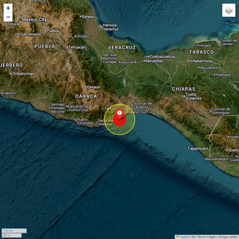
#IIGEA #SIMMSA #SISMO #EARTHQUAKE MAGNITUDE: 5.0Mw #OFFSHORE #OAXACA #MEXICO 2026-01-20, 11:30:13.812 UTC LAT: 15.9301° LON: -95.4789° DEPTH: -41.6km iigea.org/monitor

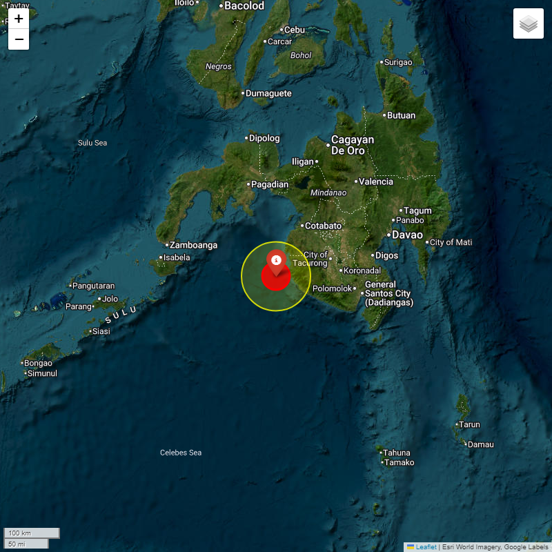
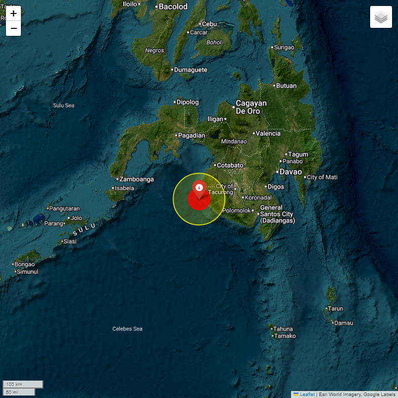
#IIGEA #SIMMSA #SISMO #EARTHQUAKE MAGNITUDE: 5.1Mw #MORO #GULF #MINDANAO #PHILIPPINES 2026-01-20, 23:25:18.05 UTC LAT: 6.409° LON: 123.816° DEPTH: -10.0km iigea.org/monitor
#IIGEA #SIMMSA #SISMO #EARTHQUAKE MAGNITUDE: 5.3Mw #ASCENSION #ISLAND #REGION 2026-01-20, 05:55:51.21 UTC LAT: -10.241° LON: -13.2013° DEPTH: -12.0km iigea.org/monitor


#IIGEA #SIMMSA #SISMO #EARTHQUAKE MAGNITUDE: 5.5Mw #TANZANIA 2026-01-20, 17:11:39.97 UTC LAT: -8.313° LON: 39.087° DEPTH: -10.0km iigea.org/monitor

#IIGEA #SIMMSA #SISMO #EARTHQUAKE MAGNITUDE: 5.3Mw #MORO #GULF #MINDANAO #PHILIPPINES 2026-01-21, 01:33:09.06 UTC LAT: 6.4661° LON: 123.8833° DEPTH: -35.0km iigea.org/monitor
#IIGEA #SIMMSA #SISMO #EARTHQUAKE MAGNITUDE: 5.0Mw #SANTA #CRUZ #ISLANDS 2026-01-20, 08:18:09.32 UTC LAT: -11.925° LON: 167.633° DEPTH: -55.3km iigea.org/monitor
#IIGEA #SIMMSA #SISMO #EARTHQUAKE MAGNITUDE: 6.4Mw #EASTERN #NEW #GUINEA #REG #P.N.G 2026-01-20, 07:21:59.18 UTC LAT: -5.3797° LON: 145.9528° DEPTH: -78.0km iigea.org/monitor

#IIGEA #SIMMSA #SISMO #EARTHQUAKE MAGNITUDE: 5.3Mw #SAMOA #ISLANDS 2026-01-20, 05:38:53.96 UTC LAT: -14.7633° LON: -172.7908° DEPTH: -29.0km iigea.org/monitor
#IIGEA #SIMMSA #SISMO #EARTHQUAKE MAGNITUDE: 5.2Mw #SOUTH #SANDWICH #ISLANDS #REGION 2026-01-21, 04:54:01.153 UTC LAT: -59.3852° LON: -25.9005° DEPTH: -35.0km iigea.org/monitor
#IIGEA #SIMMSA #SISMO #EARTHQUAKE MAGNITUDE: 5.2Mw #GANSU #CHINA 2025-09-26, 21:50:02.01 UTC LAT: 34.9255° LON: 104.5435° DEPTH: -35.0km iigea.org/monitor
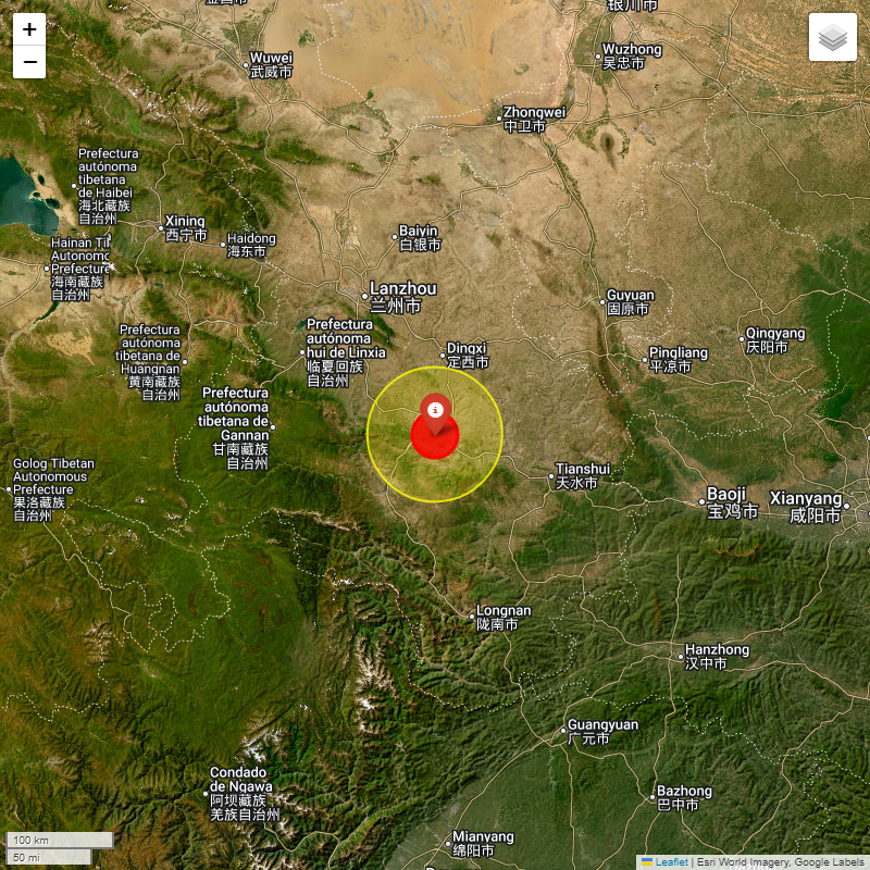
#IIGEA #SIMMSA #SISMO #EARTHQUAKE MAGNITUDE: 5.2Mw #GANSU #CHINA 2025-09-26, 21:50:02.01 UTC LAT: 34.9255° LON: 104.5435° DEPTH: -35.0km iigea.org/monitor

#IIGEA #SIMMSA #SISMO #EARTHQUAKE MAGNITUDE: 5.2Mw #NEAR #EAST #COAST #KAMCHATKA 2025-09-26, 19:29:18.31 UTC LAT: 53.169° LON: 160.285° DEPTH: -10.0km iigea.org/monitor
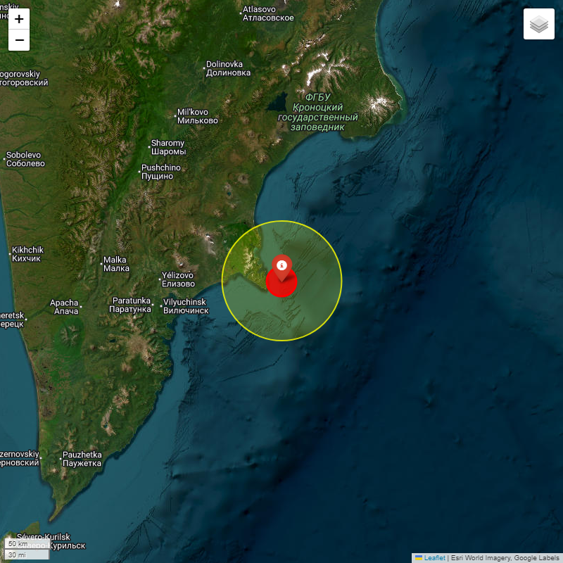
#IIGEA #SIMMSA #SISMO #EARTHQUAKE MAGNITUDE: 5.2Mw #NEAR #EAST #COAST #KAMCHATKA 2025-09-26, 19:29:18.31 UTC LAT: 53.169° LON: 160.285° DEPTH: -10.0km iigea.org/monitor

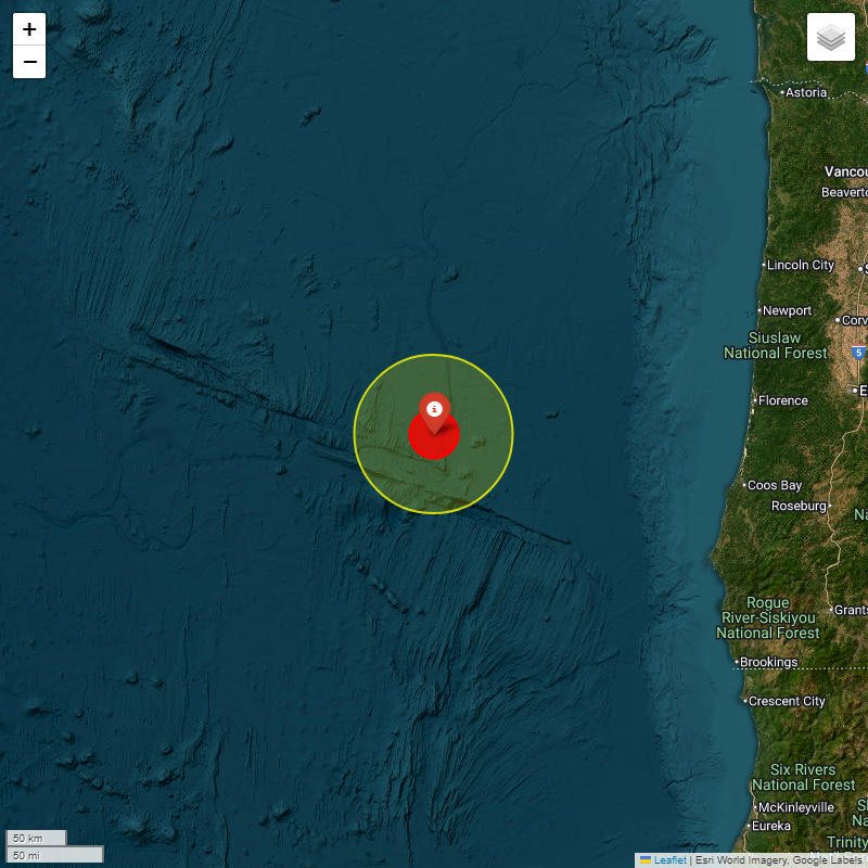
#IIGEA #SIMMSA #SISMO #EARTHQUAKE MAGNITUDE: 5.4Mw #OFF #COAST #OREGON 2025-09-26, 06:45:33.38 UTC LAT: 43.736° LON: -127.359° DEPTH: -10.0km iigea.org/monitor

#IIGEA #SIMMSA #SISMO #EARTHQUAKE MAGNITUDE: 5.4Mw #OFF #COAST #OREGON 2025-09-26, 06:45:33.38 UTC LAT: 43.736° LON: -127.359° DEPTH: -10.0km iigea.org/monitor
#IIGEA #SIMMSA #SISMO #EARTHQUAKE MAGNITUDE: 5.1Mw #TONGA 2025-09-26, 06:32:33.883 UTC LAT: -15.1011° LON: -173.4965° DEPTH: -10.0km iigea.org/monitor
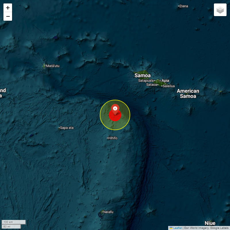
#IIGEA #SIMMSA #SISMO #EARTHQUAKE MAGNITUDE: 5.1Mw #TONGA 2025-09-26, 06:32:33.883 UTC LAT: -15.1011° LON: -173.4965° DEPTH: -10.0km iigea.org/monitor

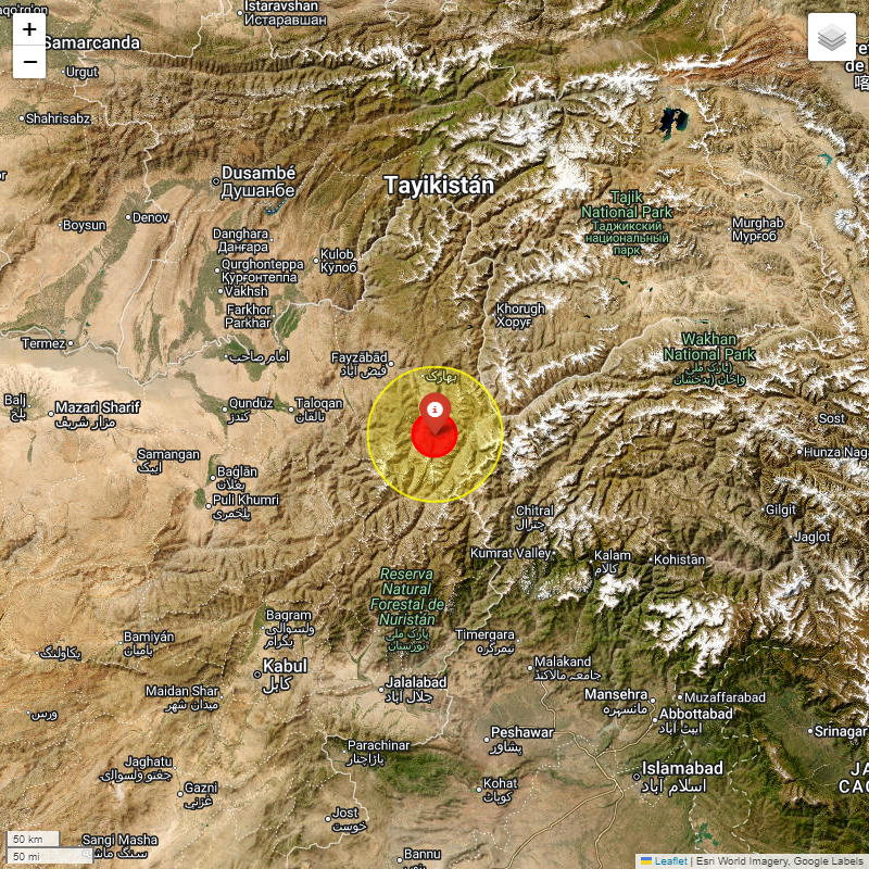
#IIGEA #SIMMSA #SISMO #EARTHQUAKE MAGNITUDE: 5.1Mw #HINDU #KUSH #REGION #AFGHANISTAN 2025-09-26, 03:17:25.51 UTC LAT: 36.5267° LON: 70.9989° DEPTH: -190.0km iigea.org/monitor

#IIGEA #SIMMSA #SISMO #EARTHQUAKE MAGNITUDE: 5.1Mw #HINDU #KUSH #REGION #AFGHANISTAN 2025-09-26, 03:17:25.51 UTC LAT: 36.5267° LON: 70.9989° DEPTH: -190.0km iigea.org/monitor
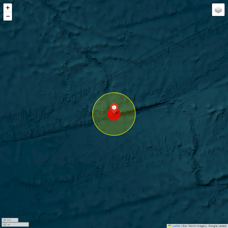
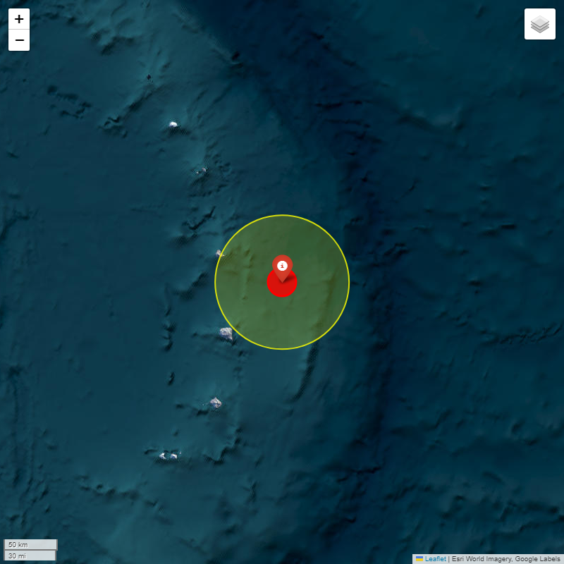
#IIGEA #SIMMSA #SISMO #EARTHQUAKE MAGNITUDE: 5.2Mw #SOUTHERN #MID-ATLANTIC #RIDGE 2025-09-25, 17:59:35.861 UTC LAT: -47.4183° LON: -13.2064° DEPTH: -10.0km iigea.org/monitor

#IIGEA #SIMMSA #SISMO #EARTHQUAKE MAGNITUDE: 5.2Mw #SOUTHERN #MID-ATLANTIC #RIDGE 2025-09-25, 17:59:35.861 UTC LAT: -47.4183° LON: -13.2064° DEPTH: -10.0km iigea.org/monitor
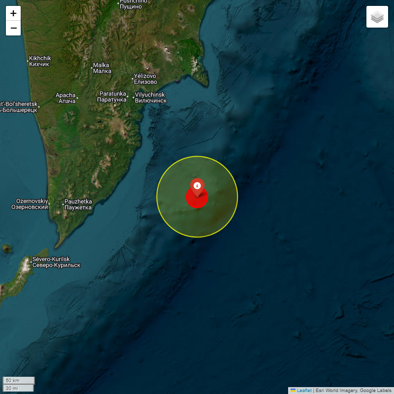
#IIGEA #SIMMSA #SISMO #EARTHQUAKE MAGNITUDE: 5.2Mw #OFF #EAST #COAST #KAMCHATKA 2025-09-25, 18:02:43.57 UTC LAT: 51.577° LON: 159.822° DEPTH: -10.0km iigea.org/monitor

#IIGEA #SIMMSA #SISMO #EARTHQUAKE MAGNITUDE: 5.2Mw #OFF #EAST #COAST #KAMCHATKA 2025-09-25, 18:02:43.57 UTC LAT: 51.577° LON: 159.822° DEPTH: -10.0km iigea.org/monitor
#IIGEA #SIMMSA #SISMO #EARTHQUAKE MAGNITUDE: 5.0Mw #TARAPACA #CHILE 2025-09-25, 18:11:44.86 UTC LAT: -19.5209° LON: -69.4596° DEPTH: -103.0km iigea.org/monitor
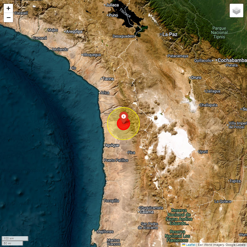
#IIGEA #SIMMSA #SISMO #EARTHQUAKE MAGNITUDE: 5.0Mw #TARAPACA #CHILE 2025-09-25, 18:11:44.86 UTC LAT: -19.5209° LON: -69.4596° DEPTH: -103.0km iigea.org/monitor

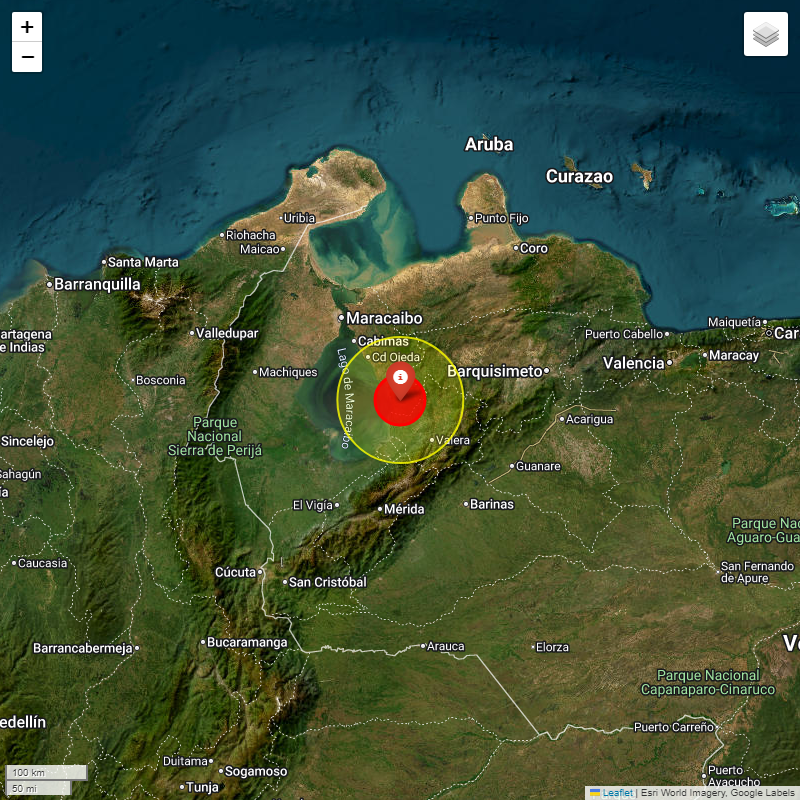
#IIGEA #SIMMSA #SISMO #EARTHQUAKE MAGNITUDE: 6.3Mw #ZULIA #VENEZUELA 2025-09-24, 22:21:58.35 UTC LAT: 9.7508° LON: -70.9567° DEPTH: -35.0km iigea.org/monitor

#IIGEA #SIMMSA #SISMO #EARTHQUAKE MAGNITUDE: 6.3Mw #ZULIA #VENEZUELA 2025-09-24, 22:21:58.35 UTC LAT: 9.7508° LON: -70.9567° DEPTH: -35.0km iigea.org/monitor
#IIGEA #SIMMSA #SISMO #EARTHQUAKE MAGNITUDE: 5.1Mw #SOUTH #SANDWICH #ISLANDS #REGION 2025-09-24, 13:36:30.796 UTC LAT: -58.0289° LON: -25.4976° DEPTH: -76.1km iigea.org/monitor
#IIGEA #SIMMSA #SISMO #EARTHQUAKE MAGNITUDE: 5.1Mw #SOUTH #SANDWICH #ISLANDS #REGION 2025-09-24, 13:36:30.796 UTC LAT: -58.0289° LON: -25.4976° DEPTH: -76.1km iigea.org/monitor


#IIGEA #SIMMSA #SISMO #EARTHQUAKE MAGNITUDE: 5.3Mw #SAMOA #ISLANDS 2026-01-20, 05:38:53.96 UTC LAT: -14.7633° LON: -172.7908° DEPTH: -29.0km iigea.org/monitor
#IIGEA #SIMMSA #SISMO #EARTHQUAKE MAGNITUDE: 5.5Mw #TANZANIA 2026-01-20, 17:11:39.97 UTC LAT: -8.313° LON: 39.087° DEPTH: -10.0km iigea.org/monitor
#IIGEA #SIMMSA #SISMO #EARTHQUAKE MAGNITUDE: 5.2Mw #ASCENSION #ISLAND #REGION 2026-01-20, 06:04:14.61 UTC LAT: -10.2866° LON: -13.0795° DEPTH: -12.0km iigea.org/monitor
#IIGEA #SIMMSA #SISMO #EARTHQUAKE MAGNITUDE: 5.1Mw #SOUTHEAST #LOYALTY #ISLANDS 2026-01-20, 23:29:59.92 UTC LAT: -22.187° LON: 170.095° DEPTH: -10.0km iigea.org/monitor
#IIGEA #SIMMSA #SISMO #EARTHQUAKE MAGNITUDE: 5.2Mw #SOUTH #SANDWICH #ISLANDS #REGION 2026-01-21, 04:54:01.153 UTC LAT: -59.3852° LON: -25.9005° DEPTH: -35.0km iigea.org/monitor
#IIGEA #SIMMSA #SISMO #EARTHQUAKE MAGNITUDE: 5.1Mw #CARLSBERG #RIDGE 2026-01-20, 11:14:43.81 UTC LAT: 4.3529° LON: 62.5102° DEPTH: -16.0km iigea.org/monitor

#IIGEA #SIMMSA #SISMO #EARTHQUAKE MAGNITUDE: 5.0Mw #OFFSHORE #OAXACA #MEXICO 2026-01-20, 11:30:13.812 UTC LAT: 15.9301° LON: -95.4789° DEPTH: -41.6km iigea.org/monitor
#IIGEA #SIMMSA #SISMO #EARTHQUAKE MAGNITUDE: 5.0Mw #SANTA #CRUZ #ISLANDS 2026-01-20, 08:18:09.32 UTC LAT: -11.925° LON: 167.633° DEPTH: -55.3km iigea.org/monitor
#IIGEA #SIMMSA #SISMO #EARTHQUAKE MAGNITUDE: 6.4Mw #EASTERN #NEW #GUINEA #REG #P.N.G 2026-01-20, 07:21:59.18 UTC LAT: -5.3797° LON: 145.9528° DEPTH: -78.0km iigea.org/monitor
#IIGEA #SIMMSA #SISMO #EARTHQUAKE MAGNITUDE: 5.3Mw #MORO #GULF #MINDANAO #PHILIPPINES 2026-01-21, 01:33:09.06 UTC LAT: 6.4661° LON: 123.8833° DEPTH: -35.0km iigea.org/monitor
#IIGEA #SIMMSA #SISMO #EARTHQUAKE MAGNITUDE: 5.5Mw #KEPULAUAN #BABAR #INDONESIA 2026-01-21, 05:49:36.76 UTC LAT: -7.17° LON: 129.644° DEPTH: -86.2km iigea.org/monitor
#IIGEA #SIMMSA #SISMO #EARTHQUAKE MAGNITUDE: 5.3Mw #ASCENSION #ISLAND #REGION 2026-01-20, 05:55:51.21 UTC LAT: -10.241° LON: -13.2013° DEPTH: -12.0km iigea.org/monitor

#IIGEA #SIMMSA #SISMO #EARTHQUAKE MAGNITUDE: 5.1Mw #VOLCANO #ISLANDS #JAPAN #REGION 2026-01-21, 04:04:20.24 UTC LAT: 24.669° LON: 141.491° DEPTH: -10.0km iigea.org/monitor
#IIGEA #SIMMSA #SISMO #EARTHQUAKE MAGNITUDE: 5.3Mw #ASCENSION #ISLAND #REGION 2026-01-20, 05:55:51.21 UTC LAT: -10.241° LON: -13.2013° DEPTH: -12.0km iigea.org/monitor
#IIGEA #SIMMSA #SISMO #EARTHQUAKE MAGNITUDE: 5.1Mw #SOUTHEAST #LOYALTY #ISLANDS 2026-01-20, 23:29:59.92 UTC LAT: -22.187° LON: 170.095° DEPTH: -10.0km iigea.org/monitor
#IIGEA #SIMMSA #SISMO #EARTHQUAKE MAGNITUDE: 5.2Mw #ASCENSION #ISLAND #REGION 2026-01-20, 06:04:14.61 UTC LAT: -10.2866° LON: -13.0795° DEPTH: -12.0km iigea.org/monitor
#IIGEA #SIMMSA #SISMO #EARTHQUAKE MAGNITUDE: 5.1Mw #MORO #GULF #MINDANAO #PHILIPPINES 2026-01-20, 23:25:18.05 UTC LAT: 6.409° LON: 123.816° DEPTH: -10.0km iigea.org/monitor
#IIGEA #SIMMSA #SISMO #EARTHQUAKE MAGNITUDE: 5.5Mw #KEPULAUAN #BABAR #INDONESIA 2026-01-21, 05:49:36.76 UTC LAT: -7.17° LON: 129.644° DEPTH: -86.2km iigea.org/monitor
#IIGEA #SIMMSA #SISMO #EARTHQUAKE MAGNITUDE: 5.5Mw #TANZANIA 2026-01-20, 17:11:39.97 UTC LAT: -8.313° LON: 39.087° DEPTH: -10.0km iigea.org/monitor
#IIGEA #SIMMSA #SISMO #EARTHQUAKE MAGNITUDE: 6.4Mw #EASTERN #NEW #GUINEA #REG #P.N.G 2026-01-20, 07:21:59.18 UTC LAT: -5.3797° LON: 145.9528° DEPTH: -78.0km iigea.org/monitor
Something went wrong.
Something went wrong.
United States Trends
- 1. $LOL N/A
- 2. #UberEats N/A
- 3. Iowa State N/A
- 4. #TakoTori1stConcert N/A
- 5. Duke N/A
- 6. Edwin Diaz N/A
- 7. #DrawnToDawn N/A
- 8. Tennessee N/A
- 9. #DragRace N/A
- 10. Sami N/A
- 11. #SmackDown N/A
- 12. Elite 8 N/A
- 13. Rick Barnes N/A
- 14. Melo N/A
- 15. UConn N/A
- 16. Izzo N/A
- 17. Michigan State N/A
- 18. Ashlon Jackson N/A
- 19. Tiger N/A
- 20. Mania N/A