#spatialequitynyc search results
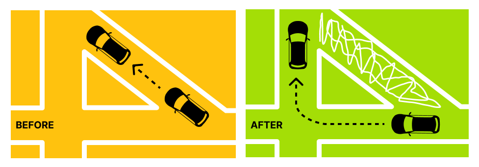
Closing slip lanes across New York City can open up so much space for new pedestrian space. For example, pedestrian plazas in slip lanes on the Grand Concourse in the Bronx reduced injuries by 45%. See more in #SpatialEquityNYC: spatialequity.nyc/?c=2&b=council…

My beautiful boys running free at Apolline’s Garden, checking out the new bee hotels. Every neighborhood deserves a street like this. ♥️


📣 Join us at @betanyc this weekend to learn more about #SpatialEquityNYC: A co-designed equity mapping tool revealing socio-spatial inequities in New York City at NYC School of Data 2023 sched.co/1JUZr #nycsodata @niko_dellic @TransAlt @mitsap @datasew

See more with #SpatialEquityNYC: transalt.org/blog/flood-ris…
transalt.org
Flood Risk is Much Higher in Black Communities. Traffic-Calming Green Infrastructure Can Help. —...
Our stormwater infrastructure is already overburdened and many neighborhoods periodically flood, and yet New York City is projected to receive 10% more rain and one foot of sea level rise by the...
I just liked “Transportation Alternatives #SpatialEquityNYC” on #Vimeo: vimeo.com/764327090

vimeo.com
Vimeo
Transportation Alternatives #SpatialEquityNYC
I think I'm addicted to #SpatialEquityNYC, a tool from @transalt and @MITLCAU. spatialequity.nyc
Vehicle traffic causes 80% of noise pollution in cities. #SpatialEquityNYC measures noise pollution from all transportation sources — airplanes included. The three council districts with the highest levels of noise pollution are all in Queens. spatialequity.nyc/?c=2&b=council…
spatialequity.nyc
Spatial Equity NYC
Spatial Equity NYC documents inequities in the ways that public space is designed, distributed, and accessed.
Start your morning with #SpatialEquityNYC trivia ⁉️ This borough has the most sidewalk space, most benches per capita, and the least amount of transportation noise, but the smallest percentage of tree canopy coverage?
With the majority of NYC's land area unable to absorb rainfall, water collects in low-lying areas — restricting mobility, damaging infrastructure, and endangering residents. See more in #SpatialEquityNYC: spatialequity.nyc/?c=2&b=council…
None of the cyclists killed this year were in protected bike lanes, and 83% were on streets without any form of bike safety infrastructure. Just 1.7% of New York City streets have protected bike lanes. ➡️ See more in #SpatialEquityNYC: spatialequity.nyc/?c=2&b=council…
spatialequity.nyc
Spatial Equity NYC
Spatial Equity NYC documents inequities in the ways that public space is designed, distributed, and accessed.
Buses on Tremont Avenue can be as slow as 5 mph A bus lane would give riders much-needed relief: 78% of commuters get to their jobs via public transit, walking or biking in Bronx CB 5 according to #SpatialEquityNYC. It's time to put bus riders first. nyc.streetsblog.org/2024/05/06/cit…
nyc.streetsblog.org
City Considers Fixes for Another Ridiculously Slow Cross-Bronx Bus - Streetsblog New York City
The administration of Mayor Eric Adams is talking about potential bus service improvements on Tremont Avenue in the Bronx.
Explore #SpatialEquityNYC today: 1. Go to spatialequity.nyc 2. Find your district 3. Demand action from our elected officials
spatialequity.nyc
Spatial Equity NYC
Spatial Equity NYC documents inequities in the ways that public space is designed, distributed, and accessed.
How does your district rank? Explore tree canopy in #SpatialEquityNYC: spatialequity.nyc/?c=2&b=council…
To help prevent flooding, pay attention to the design and use of public spaces. See how we can prevent flooding in #SpatialEquityNYC: spatialequity.nyc/?c=2&b=council…
To reduce air pollution and asthma rates in your neighborhood, pay attention to the design and use of public spaces. Explore more in #SpatialEquityNYC: spatialequity.nyc/?c=3&b=council…
Local Law 148-2023 passed the City Council overwhelmingly last year 47-0, which requires the City’s tree canopy to increase to 30%. As of now, only 6 of the 51 Council districts have 30% coverage according to #SpatialEquityNYC. crainsnewyork.com/op-ed/nycs-fir…
Air pollution levels in Midtown are dangerously-high. We can remove polluting cars & trucks from the street. A redesign makes room for trees, providing relief from the heat & making our streets resilient against climate change. In #SpatialEquityNYC: spatialequity.nyc/?c=2&b=communi…
spatialequity.nyc
Spatial Equity NYC
Spatial Equity NYC documents inequities in the ways that public space is designed, distributed, and accessed.
In #SpatialEquityNYC, see how your neighborhood ranks for air pollution against the rest of the city — and take action to correct inequities from neighborhood-to-neighborhood. spatialequity.nyc/?c=2&b=council…
spatialequity.nyc
Spatial Equity NYC
Spatial Equity NYC documents inequities in the ways that public space is designed, distributed, and accessed.
➡️ Create truck traffic deterrents by using gateways to narrow residential streets using curb extensions, trees, bike parking, & benches to prevent/discourage truck traffic from using these streets as alternate routes. Explore more in #SpatialEquityNYC: spatialequity.nyc/?&swM=f&sdC=2&…
spatialequity.nyc
Spatial Equity NYC
Spatial Equity NYC documents inequities in the ways that public space is designed, distributed, and accessed.
To reduce air pollution and asthma rates in your neighborhood, pay attention to the design and use of public spaces. Explore more in #SpatialEquityNYC: spatialequity.nyc/?c=3&b=council…
Visit #SpatialEquityNYC to explore surface temperatures across the city. spatialequity.nyc/?c=2&b=council…
spatialequity.nyc
Spatial Equity NYC
Spatial Equity NYC documents inequities in the ways that public space is designed, distributed, and accessed.
To help prevent flooding, pay attention to the design and use of public spaces. See how we can prevent flooding in #SpatialEquityNYC: spatialequity.nyc/?c=2&b=council…
Local Law 148-2023 passed the City Council overwhelmingly last year 47-0, which requires the City’s tree canopy to increase to 30%. As of now, only 6 of the 51 Council districts have 30% coverage according to #SpatialEquityNYC. crainsnewyork.com/op-ed/nycs-fir…
See more with #SpatialEquityNYC: transalt.org/blog/flood-ris…
transalt.org
Flood Risk is Much Higher in Black Communities. Traffic-Calming Green Infrastructure Can Help. —...
Our stormwater infrastructure is already overburdened and many neighborhoods periodically flood, and yet New York City is projected to receive 10% more rain and one foot of sea level rise by the...
🌳🐿️ Want to sploot like Mr. Squirrel today? Visit #SpatialEquityNYC to discover the tree canopy in your neighborhood! ➡️ spatialequity.nyc
spatialequity.nyc
Spatial Equity NYC
Spatial Equity NYC documents inequities in the ways that public space is designed, distributed, and accessed.
It’s sploot season! To cool off and reduce body heat during hot days, squirrels will stretch out (sploot) on cool surfaces like this shady patch of soil.

Visit #SpatialEquityNYC to explore surface temperatures across the city. spatialequity.nyc/?c=1&b=council…
spatialequity.nyc
Spatial Equity NYC
Spatial Equity NYC documents inequities in the ways that public space is designed, distributed, and accessed.
Vehicle traffic causes 80% of noise pollution in cities. #SpatialEquityNYC measures noise pollution from all transportation sources — airplanes included. The three council districts with the highest levels of noise pollution are all in Queens. spatialequity.nyc/?c=2&b=council…
spatialequity.nyc
Spatial Equity NYC
Spatial Equity NYC documents inequities in the ways that public space is designed, distributed, and accessed.
How does your district rank? Explore tree canopy in #SpatialEquityNYC: spatialequity.nyc/?c=2&b=council…
Closing slip lanes across New York City can open up so much space for new pedestrian space. For example, pedestrian plazas in slip lanes on the Grand Concourse in the Bronx reduced injuries by 45%. See more in #SpatialEquityNYC: spatialequity.nyc/?c=2&b=council…

My beautiful boys running free at Apolline’s Garden, checking out the new bee hotels. Every neighborhood deserves a street like this. ♥️


Air pollution levels in Midtown are dangerously-high. We can remove polluting cars & trucks from the street. A redesign makes room for trees, providing relief from the heat & making our streets resilient against climate change. In #SpatialEquityNYC: spatialequity.nyc/?c=2&b=communi…
spatialequity.nyc
Spatial Equity NYC
Spatial Equity NYC documents inequities in the ways that public space is designed, distributed, and accessed.
Start your morning with #SpatialEquityNYC trivia ⁉️ This borough has the most sidewalk space, most benches per capita, and the least amount of transportation noise, but the smallest percentage of tree canopy coverage?
Buses on Tremont Avenue can be as slow as 5 mph A bus lane would give riders much-needed relief: 78% of commuters get to their jobs via public transit, walking or biking in Bronx CB 5 according to #SpatialEquityNYC. It's time to put bus riders first. nyc.streetsblog.org/2024/05/06/cit…
nyc.streetsblog.org
City Considers Fixes for Another Ridiculously Slow Cross-Bronx Bus - Streetsblog New York City
The administration of Mayor Eric Adams is talking about potential bus service improvements on Tremont Avenue in the Bronx.
None of the cyclists killed this year were in protected bike lanes, and 83% were on streets without any form of bike safety infrastructure. Just 1.7% of New York City streets have protected bike lanes. ➡️ See more in #SpatialEquityNYC: spatialequity.nyc/?c=2&b=council…
spatialequity.nyc
Spatial Equity NYC
Spatial Equity NYC documents inequities in the ways that public space is designed, distributed, and accessed.
New York City is projected to receive 10% more rain by the 2030s, further endangering our most vulnerable communities. Explore #SpatialEquityNYC. Find your district, and demand action from your elected leaders today. spatialequity.nyc/?c=1&b=senate&…
spatialequity.nyc
Spatial Equity NYC
Spatial Equity NYC documents inequities in the ways that public space is designed, distributed, and accessed.
With the majority of NYC's land area unable to absorb rainfall, water collects in low-lying areas — restricting mobility, damaging infrastructure, and endangering residents. See more in #SpatialEquityNYC: spatialequity.nyc/?c=2&b=council…
In #SpatialEquityNYC, see how your neighborhood ranks for air pollution against the rest of the city — and take action to correct inequities from neighborhood-to-neighborhood. spatialequity.nyc/?c=2&b=council…
spatialequity.nyc
Spatial Equity NYC
Spatial Equity NYC documents inequities in the ways that public space is designed, distributed, and accessed.
To help prevent flooding, our leaders must attention to the design and use of public spaces. Here are a few ways to improve spatial equity in #SpatialEquityNYC: spatialequity.nyc/?c=2&b=council…
Explore #SpatialEquityNYC today: 1. Go to spatialequity.nyc 2. Find your district 3. Demand action from our elected officials
spatialequity.nyc
Spatial Equity NYC
Spatial Equity NYC documents inequities in the ways that public space is designed, distributed, and accessed.
If you want to see how powerful data + maps are to tell a story, check out this powerful video and maps created by #SpatialEquityNYC. These maps allows users to use Census data to demonstrate the consequences of inequity. #mondaymapday #builtwithmapbox buff.ly/3s5Gy8y.

📣 Join us at @betanyc this weekend to learn more about #SpatialEquityNYC: A co-designed equity mapping tool revealing socio-spatial inequities in New York City at NYC School of Data 2023 sched.co/1JUZr #nycsodata @niko_dellic @TransAlt @mitsap @datasew

📣 Delighted to launch #SpatialEquityNYC with @TransAlt. Explore + discover your neighborhood, and learn how to advocate for change! @datasew @danielacoray @niko_dellic @a_jari @DannyHarris_TA @miatkowski @jessiesingernyc @EmFriedenberg @katielorah #spatialequity @mitsap @MITdusp


Not all streets are created equal. Today we're launching Spatial Equity NYC with @MITLCAU to reveal how inequities in public space contribute to racial and economic disparities across New York City neighborhoods. See the data. Take action. ➡️ spatialequity.nyc
Traffic violence continues to harm the Bronx at a disproportionate level: 1 in 4 traffic fatalities occurred in the Bronx. 5 of the Bronx's 8 council districts have a traffic fatality rate above the citywide average, according to #SpatialEquityNYC. ➡️ spatial-equity.herokuapp.com/?&swM=false&sw…

Save the date for our virtual #SpatialEquityNYC walkthrough at noon on Thursday, December 1! RSVP: transalt.org/sepdemo

You're invited to a virtual #SpatialEquityNYC demo at noon on Thursday, December 1. We'll walkthrough the site, show you what you can learn, and how you can apply it. RSVP: transalt.org/sepdemo

District 33 has the highest air pollution levels in NYC outside Manhattan. Its lack of 🌳 isn't helping. It ranks 40th for tree canopy, according to #SpatialEquityNYC, but this plan from @CMRestler to plant 3,400 trees is a step in the right direction. thecity.nyc/brooklyn/2022/…

Policies about public space correlate with disparities in health, mobility, and the environment — and it’s time to change our deadly status quo. Sign our petition and tell your council member to commit to ending spatial inequity. #SpatialEquityNYC ✏️ transalt.org/EndSpatialIneq…

Great 🌳🌳🌳 news for District 3. According to #SpatialEquityNYC, District 3 has the least tree canopy coverage in the city. 1,000 new trees will make a difference — removing pollution, lowering the air temperature, and mitigating flooding. ➡️ spatialequity.nyc/?&swM=f&sdC=2&…

Pics from our announcement of 1,000 new street trees in Council District 3! 🌳


In Council District 40: • 57.8% of households are car-free • 70% of commuters walk, bike, or take transit Yet buses in District 40 are slower than the citywide average at 5.9 mph. Flatbush Avenue needs a bus lane. See more with #SpatialEquityNYC: bit.ly/3UbSscX

We NEED a Flatbush Avenue bus lane. It’s not a luxury, it’s a necessity. Transit equity and street safety can’t be after-thoughts anymore. Both the health of our planet and our neighbors are at risk if we don’t fix our street design and transit issues with urgency.
Closing slip lanes across New York City can open up so much space for new pedestrian space. For example, pedestrian plazas in slip lanes on the Grand Concourse in the Bronx reduced injuries by 45%. See more in #SpatialEquityNYC: spatialequity.nyc/?c=2&b=council…

My beautiful boys running free at Apolline’s Garden, checking out the new bee hotels. Every neighborhood deserves a street like this. ♥️


It was great to celebrate the launch of @TransAlt’s #SpatialEquityNYC tool today with advocates! Spatial Equity NYC documents inequities in the ways that public space-including streets, sidewalks, and greenspaces-is designed, distributed, and accessed. spatialequity.nyc

Something went wrong.
Something went wrong.
United States Trends
- 1. #UFC322 142K posts
- 2. Islam 239K posts
- 3. Morales 35.5K posts
- 4. Valentina 15.1K posts
- 5. Prates 33.5K posts
- 6. Sark 5,950 posts
- 7. Kirby 18.4K posts
- 8. Georgia 84.5K posts
- 9. Zhang 26.4K posts
- 10. #GoDawgs 9,590 posts
- 11. Ole Miss 12K posts
- 12. Leon 72.9K posts
- 13. Arch 22.1K posts
- 14. Sean Brady 6,728 posts
- 15. Khabib 6,316 posts
- 16. Dillon Danis 9,395 posts
- 17. Dagestan 1,556 posts
- 18. Ahmad Hardy 1,280 posts
- 19. Bo Nickal 7,050 posts
- 20. Texas 198K posts


