#typhoon search results

SUPER TYPHOON SIMLAC CAT 5, NASA 14/4/26 Super Typhoon Sinlaku, notable for reaching such exceptional strength so early in the year. High ocean surface temperatures are turbocharging powerful storms. science.nasa.gov/earth/earth-ob…. #typhoon #climatechange. #globalwarming


🚨إعصار سينلاكو يضرب جزر ماريانا الشمالية الآن،، تؤثر العاصفة القوية حالياً بشكل مباشر على جزر ماريانا الشمالية في المحيط الهادئ، مع وصول رياح عنيفة وأمطار غزيرة إلى مناطق تشمل سايبان وتينيان، بعد أن مرّت قرب غوام دون تأثير مباشر كبير. #Typhoon #NorthernMarianaIslands #Saipan
Mirad el efecto estadio del Super Tifón Sinlaku. Lleva más de 24h manteniendo un ojo casi perfecto. #Sinlaku #Typhoon #Guam #Meteo #Weather #Cyclone

High-rise apartments in #China. Walls and windows blown away by a #typhoon Video from @qsfkbwIhuWLhnjI

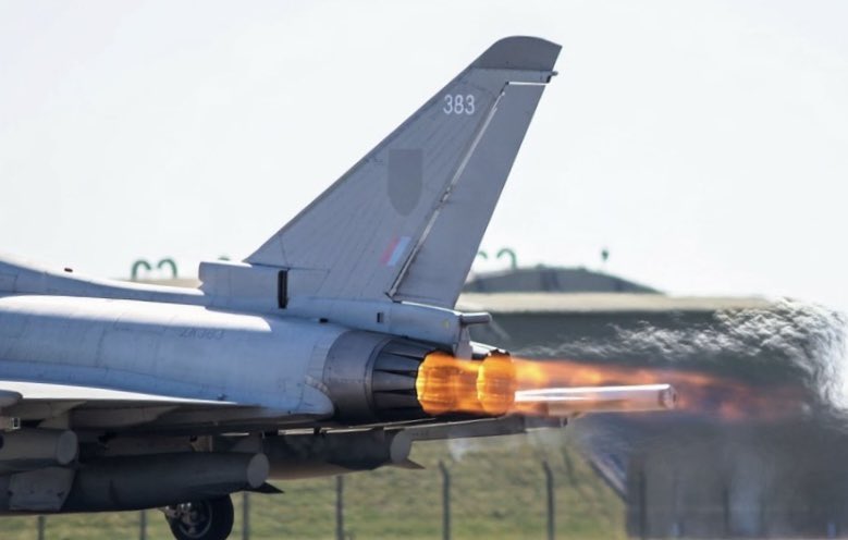
The Eurofighter Typhoon was designed for air superiority with exceptional speed and maneuverability. Its advanced radar and sensor systems allow it to track multiple aerial targets simultaneously. #FighterJet #Typhoon #MilitaryMechanics


Well Super #Typhoon #Sinlaku is CLOSING IN on the Mariana Islands, specifically Tinian and Saipan. If you are on the islands, preparations NEED TO BE COMPLETED SOON! HUNKER DOWN! THIS IS A LIFE THREATENING SITUATION! #wx

PRECAUCIÓN 🌀 El Súper #Typhoon #Sinlaku en aproximación a las Islas Marianas, con vientos sostenidos de 278 km/h, Categoría 5! Alerta máxima, riesgo extremo, potencialmente catastrófico. Abril 13 de 2026


I don’t think I’ve ever seen such tight model agreement 24hrs out - GFS, ECM, HWRF, HFAS all zeroed in on Saipan. Wobbles really matter in these situations with a few km deviation one way or another having a significant effect on the scale of impact #typhoon #sinlaku


The most recent GFS runs are unfortunately showing #Guam could get a DIRECT HIT from #Typhoon #Sinlaku as a CATEGORY 5 SUPER TYPHOON within the next 3 days. If this were to verify, CATASTROPHIC IMPACTS would likely occur. Preparations need to be completed BY TOMORROW NIGHT!
LANDFALL! #Typhoon #Sinlaku has just made landfall on the islands of Tinian and Saipan, bringing MAJOR IMPACTS in the form of wind and rain. Also, you can clearly see the Eyewall Replacement Cycle nearly finished on satellite! #wx


STORMS FROM SPACE 🌀: 4K imagery captured aboard the International Space Station showcases the strength of Super Typhoon Sinlaku, entailing its 185 mph winds as the strong storm rampaged. #Space #Severewx #Typhoon #FOXWeather
QUE LOCURA! Así amanece el Super Tifón Sinlaku. Se ha convertido oficialmente en el súper tifón temprano más intenso, superando a Surigae (2021). Se dirige hacia Guam y las Islas Marianas del Norte, donde puede dejar efectos devastadores. #Sinlaku #Typhoon #Weather #Meteo
Well #Typhoon #Sinlaku is now RAPIDLY INTENSIFYING and is expected to reach SUPER TYPHOON intensity before it SLAMS into the Mariana Islands, delivering MAJOR IMPACTS! Preparations NEED to be completed by TOMORROW MORNING! Will be streaming later to answer your questions! #wx
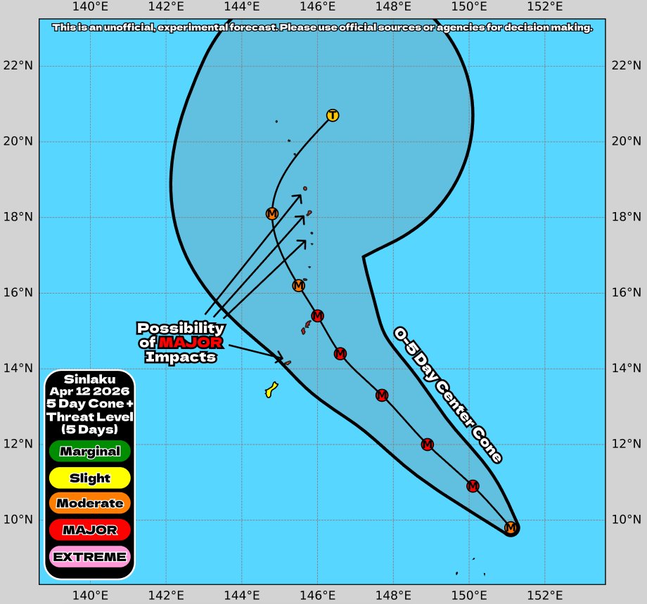
Unofficial #HCCTWO (1) #Sinlaku expected to become a SUPER #TYPHOON as it approaches the Mariana Islands (2) #Vaianu about to make landfall in #NewZealand (3) #Maila less likely to redevelop (4) A disturbance could briefly form in the SWIO #cyclone
El Super Tifón Sinlaku es una bestia! Lleva más de 12h manteniendo un ojo casi perfecto. Su presión se ha desplomado más de 50mb en menos de 24h y sus vientos superan los 275km/h!! #Sinlaku #Typhoon #Weather #Meteo


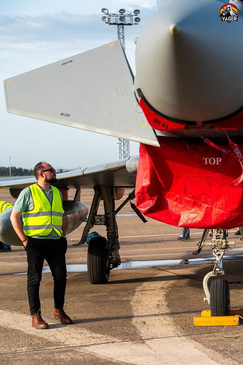
Siempre me ha encantado contemplar bien de cerca los aviones. En calma, con detenimiento, y apreciando como cada pequeño detalle es capaz de crear tanta magia. Gracias @yager821 por este pedazo de robado. #Eurofighter #Typhoon

hoping @comconwales can get one or two more wrestlers for August 🙏 @RealHacksawJim @trishstratuscom #Typhoon #Tugboat @MDMTedDiBiase @NativeTatanka @brutusbeefcake_

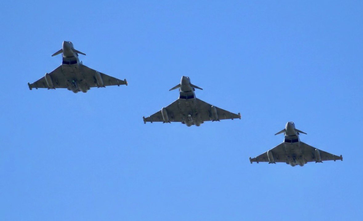
Nothing beats the lines of a Delta wing. A Cinematic views of the Luftwaffe's finest. Can you name all the hardware on those pylons? #Eurofighter #Typhoon #Luftwaffe #aviation #MilitaryJet instagram.com/reel/DX2WUpjyG…
instagram.com
CaptainFiroz Gandhi (@captain.firozgandhipilot) • Instagram reel
CaptainFiroz Gandhi (@captain.firozgandhipilot) • Instagram reel

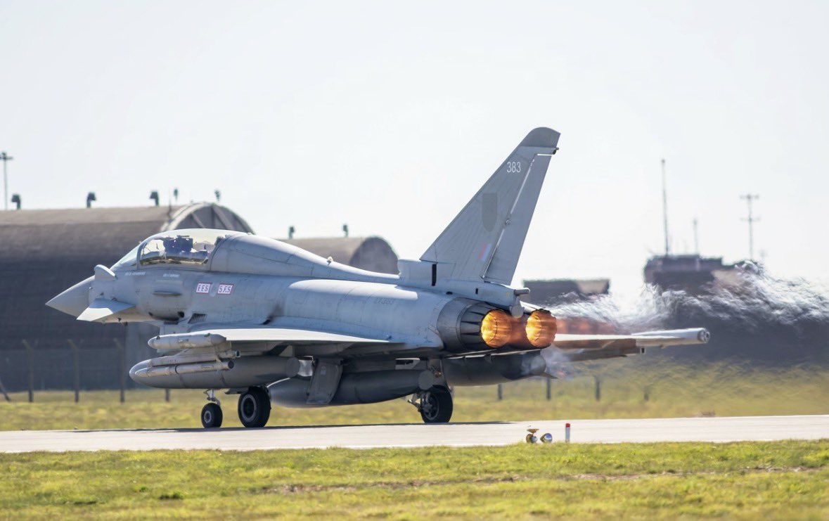
Desde esta perspectiva, el #Typhoon me parece precioso. En este caso un FGR.4 de la #RAF despegando de #Nellis AFB, Nevada, durante el ejercicio Red Flag-Nellis 26-1 (#USAF photo by Staff Sgt. Jake Jacobsen)

High-rise apartments in #China. Walls and windows blown away by a #typhoon Video from @qsfkbwIhuWLhnjI

Grape growers — protect your clusters without pushing back harvest. TYPHOON delivers fast, broad-spectrum disease control as a contact biofungicide. Spray closer to harvest with confidence. 👉 rovensanext-na.com/en-us/agricult… #TYPHOON #Biofungicide #DiseaseControl #Grapes #RovensaNext


My favorite catch from @RAFConingsby base today. Who knew the Typhoon was such a fan of its 5-a-day? 🥕🔥 #Typhoon #JetPhotography #PlanesSpotting

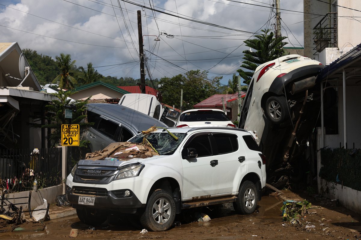
Typhoon Sinlaku has caused widespread and severe damage to housing, infrastructure, crops and essential services in Chuuk State in the Federated States of Micronesia, with the most significant impacts in remote and outer island communities. #WorldSignalHQ #Micronesia #Typhoon

Niemcy inwestują w zdolności myśliwców @eurofighter #Typhoon do rażenia celów naziemnych. Łącznie maja kupić ponad 3200 pocisków #Brimstone 3 od @MBDADeutschland. Pierwsze zamówienie to ponad 270 pocisków bojowych plus wyposażenie. @bundeswehrInfo portalobronny.se.pl/przemysl-zbroj…


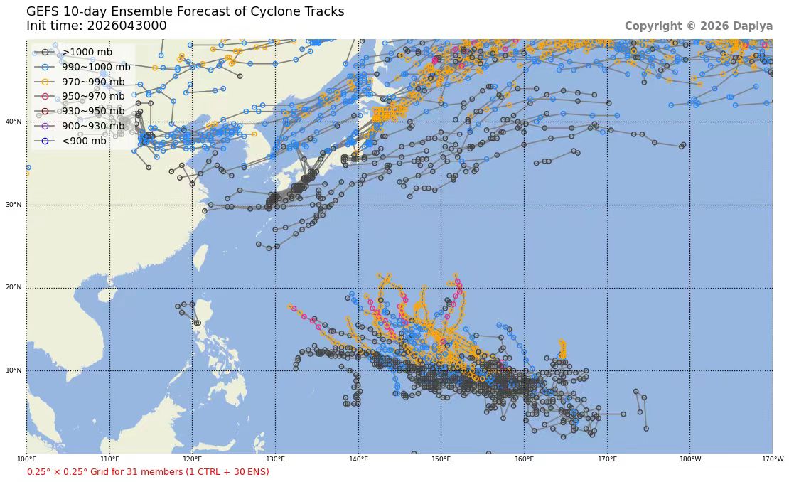
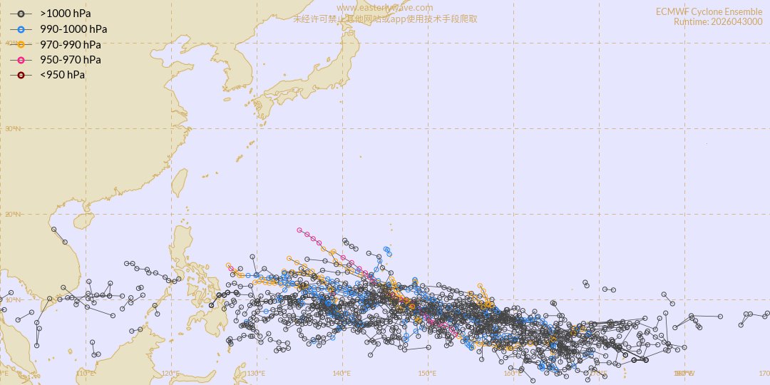
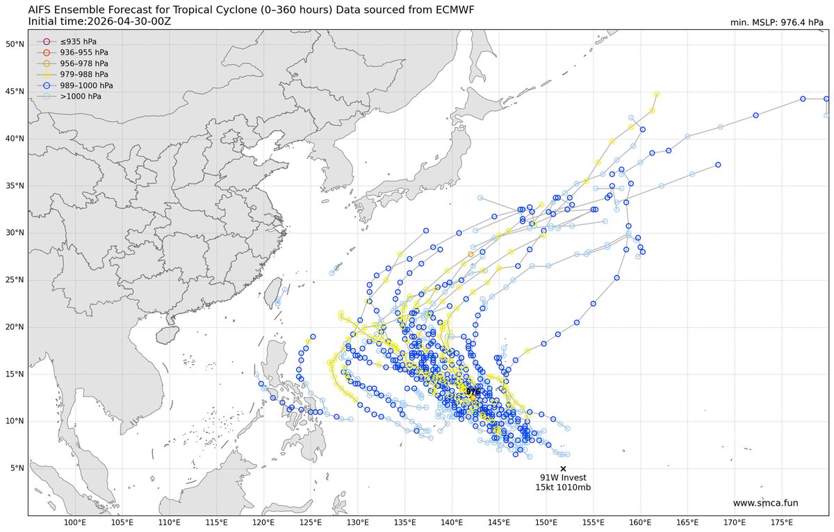
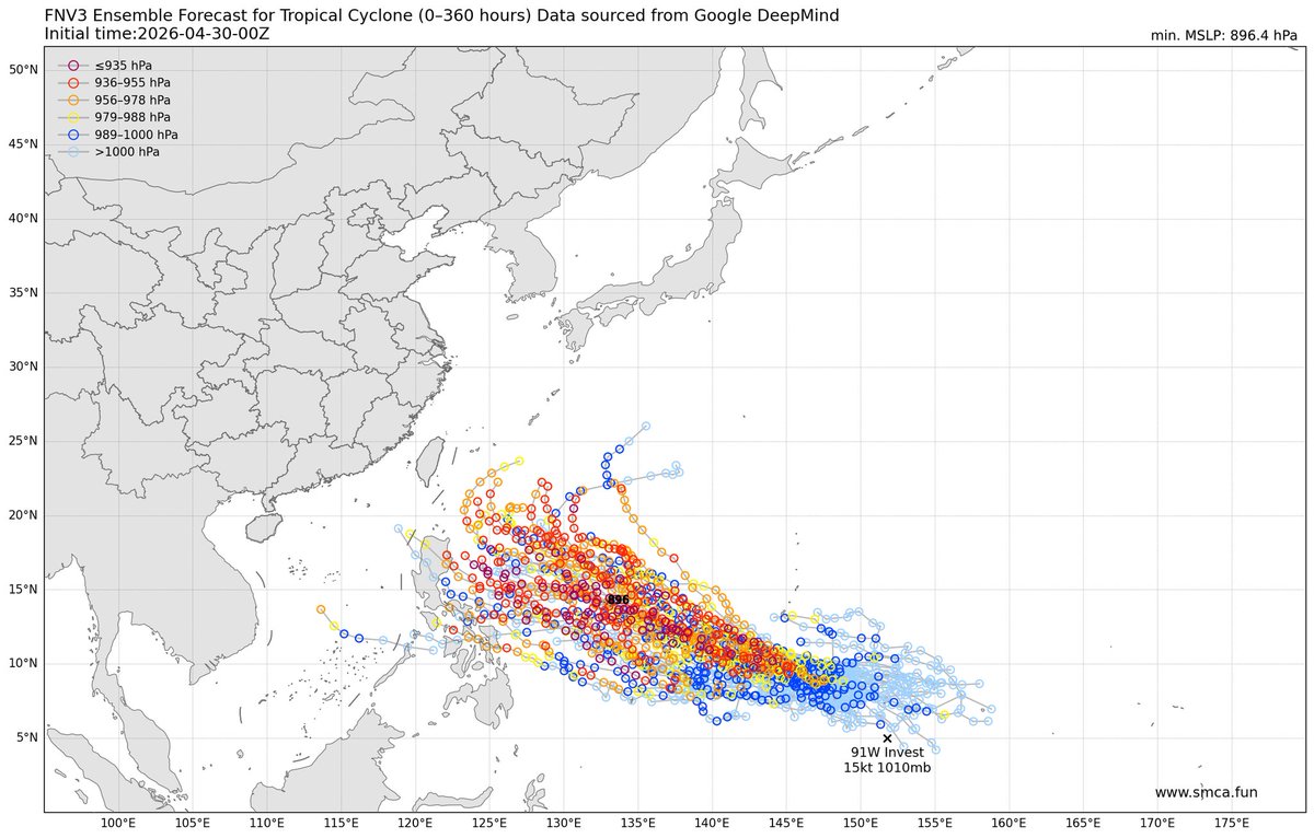

#APMetTWO 26D120 Global #TropicalWeather Outlook April 30, 2026 @ 2:20 AM UTC End(-ish) of the southern hemisphere season. == [DB] East of the Marianas: ~0% / 40% A suspected cluster of storms may develop into a potentially significant #typhoon this weekend or early next week.
![APGMeteorology's tweet image. #APMetTWO 26D120
Global #TropicalWeather Outlook
April 30, 2026 @ 2:20 AM UTC
End(-ish) of the southern hemisphere season.
==
[DB] East of the Marianas: ~0% / 40%
A suspected cluster of storms may develop into a potentially significant #typhoon this weekend or early next week.](https://pbs.twimg.com/media/HHHog7pX0AAs8Ox.jpg)

On behalf of our islands, we thank you all for launching this campaign to assist the #marianas in recovery! This #typhoon decades our islands and we need your help! #relief #crypto

Hi everyone, I don’t often make asks, but this one matters. If you can take a moment to share this video and support the people of the Northern Mariana Islands, I would truly appreciate it. Thank you in advance for any support you can give. Donate directly to the Official
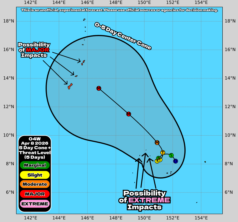
#APMetTWO 26D119 Global #TropicalWeather Outlook April 29, 2026 @ 1:20 AM UTC == [DB] East of the Marianas: ~0% / 40% A suspected cluster of storms has been marked. This system may develop into a potentially significant #typhoon this weekend or early next week.
![APGMeteorology's tweet image. #APMetTWO 26D119
Global #TropicalWeather Outlook
April 29, 2026 @ 1:20 AM UTC
==
[DB] East of the Marianas: ~0% / 40%
A suspected cluster of storms has been marked. This system may develop into a potentially significant #typhoon this weekend or early next week.](https://pbs.twimg.com/media/HHCRaldXYAAifTc.jpg)

Sincronía y potencia pura en la Base Aérea de Albacete. Ver salir a dos de estos colosos juntos es sentir la precisión del Ala 14. Después, el rugido individual de cada Eurofighter ¡Nada como vivir el despegue a pie de pista! 🫡 #Typhoon #C16 #SpainAirForce #eurofigtertyphoon

DAISHI DANCE × →Pia-no-jaC← 「Typhoon (DAISHI DANCE Remix)」 今日の料理中の一曲 夕暮れにめっちゃ合う ピアノが好きならぜひ #DAISHIDANCE #PianojaC #Typhoon

Typhoon Sinlaku: a fifth crew member has been confirmed dead, five remain missing off Saipan. Vigils are being held. The search continues. #WorldSignalHQ #Pacific #Typhoon
#APMetTWO 26D118 Global #TropicalWeather Outlook April 28, 2026 @ 3:00 AM UTC Well. Things have certainly happened. == [AOI] East of the Marianas: ~0% / 40% A potentially significant #typhoon has a modest chance to develop over the coming days.
![APGMeteorology's tweet image. #APMetTWO 26D118
Global #TropicalWeather Outlook
April 28, 2026 @ 3:00 AM UTC
Well. Things have certainly happened.
==
[AOI] East of the Marianas: ~0% / 40%
A potentially significant #typhoon has a modest chance to develop over the coming days.](https://pbs.twimg.com/media/HG9erBNbIAAGOqa.jpg)


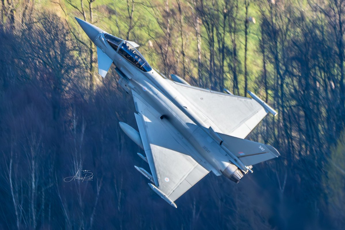
Special photo. Always wanted to try myself with fast jets. Eurofighter Typhoon ZK347 passing Thirwell, becoming my first fast jet through The Lakes. Big thank you to my good friend @foxyknoxy99. @RoyalAirForce @RAFConingsby @eurofighter @RAFTyphoonTeam @TyphoonDisplay 🇬🇧 #Typhoon


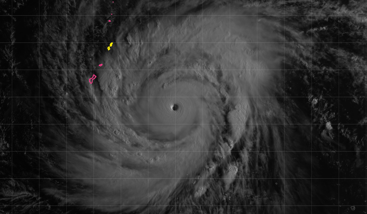
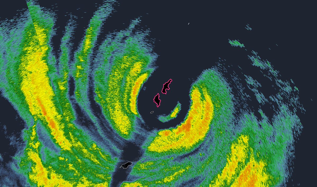
#Typhoon #SINLAKU is nearing Mariana Islands but fortunately weakening—perhaps significantly. IR & radar imagery suggest inner eyewall—which is now completely moated & detached—is about to collapse, yielding huge new eye. I'll bet max winds have already shifted to outer eyewall.

We now have Tropical Depression #04W in the Western Pacific which is expected to intensify into a possible SUPER #TYPHOON and get worryingly close to the Mariana Islands, including #Guam, where they have possibility of getting MAJOR IMPACTS! #wx
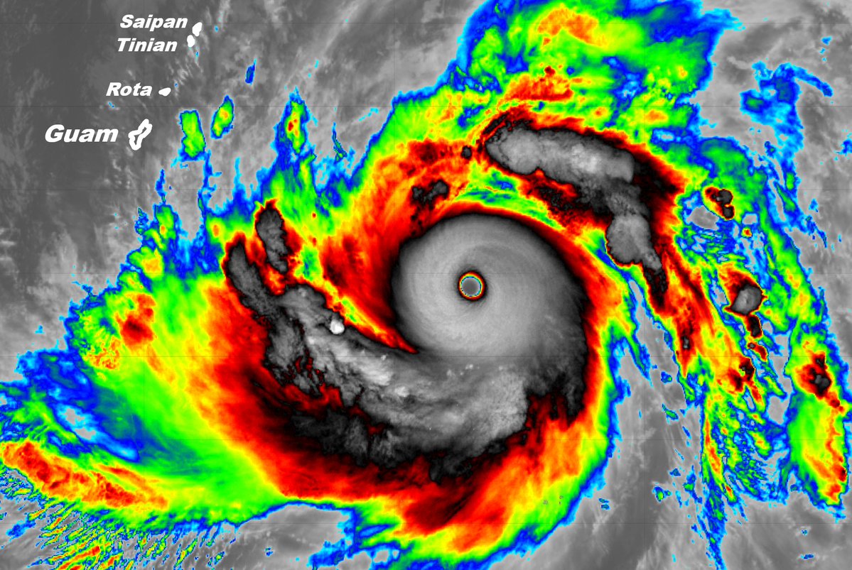
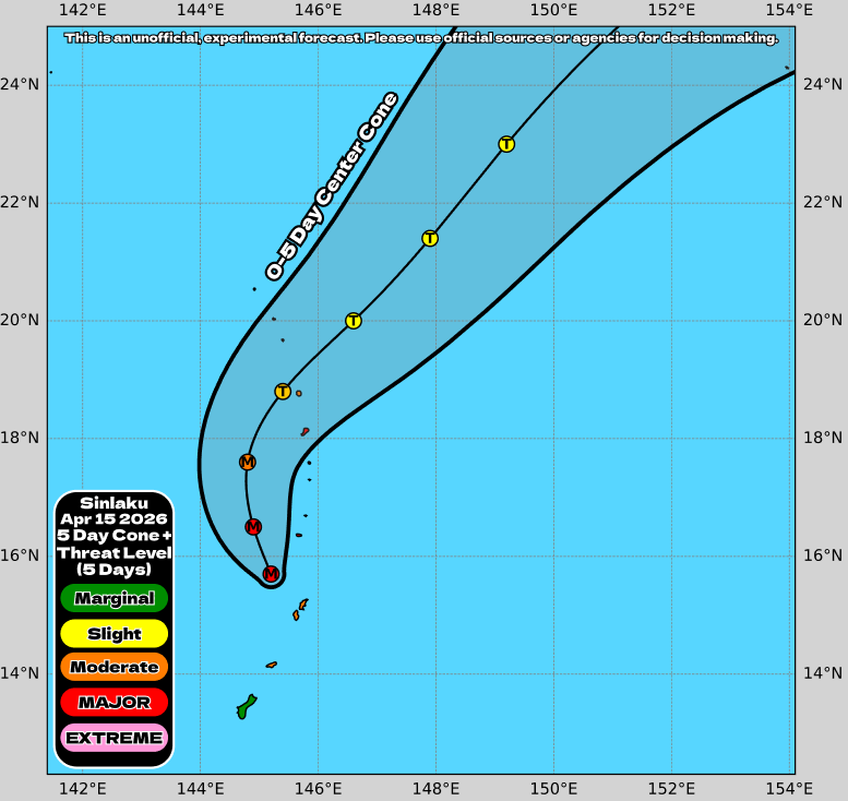
Morning light reveals Super #Typhoon #SINLAKU. Estimated intensity: a whopping 155 knots. Satellite presentation: SPECTACULAR. It'll approach Tinian (pop. ~2K) & Saipan (pop. ~43K) (yellow) tomorrow, making a potential direct hit. COMPLETE PREPARATIONS TODAY, BEFORE DARK.
SUPER TYPHOON SIMLAC CAT 5, NASA 14/4/26 Super Typhoon Sinlaku, notable for reaching such exceptional strength so early in the year. High ocean surface temperatures are turbocharging powerful storms. science.nasa.gov/earth/earth-ob…. #typhoon #climatechange. #globalwarming
Super #Typhoon #SINLAKU is now in radar range. Estimated winds were 160 knots earlier! But latest radar & satellite images suggest it's past its peak—cloud tops are warming & there's hints of eyewall replacement cycle (ERC). Even so, it's likely to be intense impact for Tinian &
A highlight of 2025 was a long held desire to photo military jets through the valleys. With the help of my great friend @foxyknoxy99 this day came in November in the Lake District. Many thanks to the @RoyalAirForce for providing the #Eurofighter #Typhoon. 🇬🇧 #AirbusRedBestOf2025

Behold Super #Typhoon #SINLAKU eyeing Mariana Islands with menacing curiosity. Winds are estimated at 130 knots (high-end Cat 4), but latest imagery suggest they're higher. Computer models suggest Guam should escape worst, whereas Saipan & Tinian could get direct hit Tuesday.

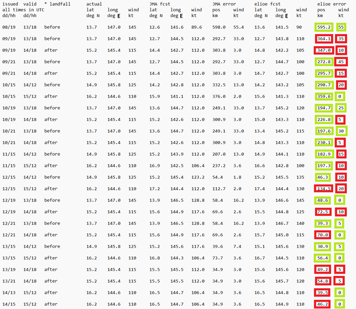
Performance of the comparable forecast points closest to landfall of #Typhoon #Sinlaku , both before and after - in 23/50 cases, I was more erroneous than @JMA_kishou - in 27/50 cases, I was less erroneous than JMA #mpwx #tropicswx
Total cinnabun structure now. I doubt the max winds are in that inner ring anymore—not when it's that detached, that moated. #Typhoon #SINLAKU


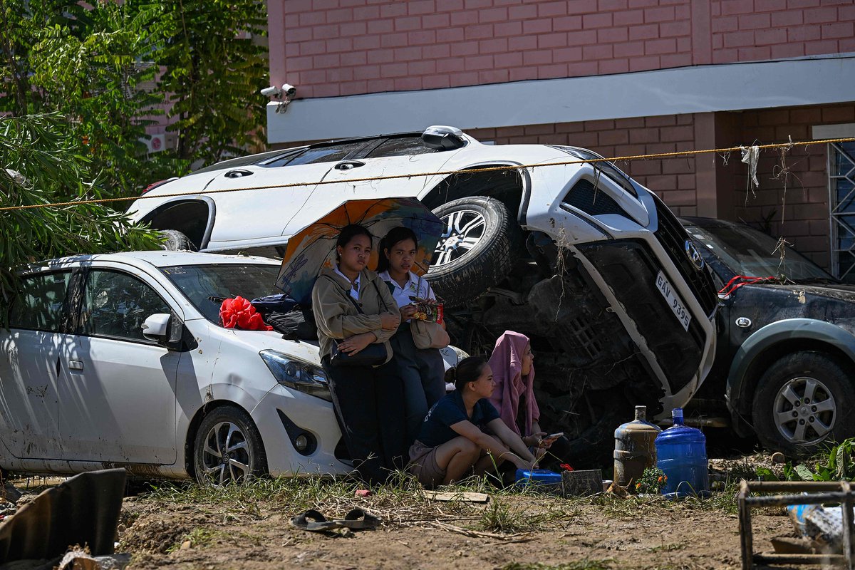
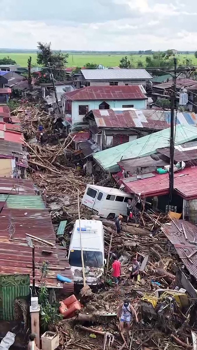
Philippine President Ferdinand Romualdez #Marcos declared a state of national #calamity due to the impact of #Typhoon #Kalmaegi and in anticipation of an upcoming typhoon, local media reported Thursday. Kalmaegi, the 20th typhoon to slam the Philippines this year, left the

Major #Typhoon #Sinlaku is leaving Tinian and Saipan but is expected to continue impacting the Mariana Islands for the next 48 hours or so with MAJOR IMPACTS in the form of flooding! #wx
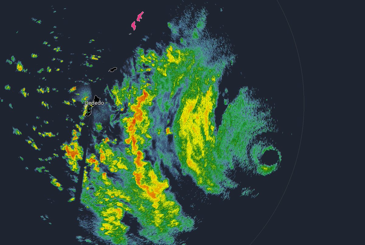
Radar shows Super #Typhoon #SINLAKU—still Cat 5—approaching Tinian & Saipan (pink). System is attempting an eyewall replacement cycle (ERC). See how innermost ring is detaching from rest of cyclone, with clean moat developing around it? That's how you know. If process continues,

PRECAUCIÓN 🌀 El Súper #Typhoon #Sinlaku en aproximación a las Islas Marianas, con vientos sostenidos de 278 km/h, Categoría 5! Alerta máxima, riesgo extremo, potencialmente catastrófico. Abril 13 de 2026
Radar images suggest inner eyewall of #Typhoon #SINLAKU has dissipated, leaving very large eye that's now passing over Tinian & Saipan (pink). A little while ago, SPN had 71 knots gusting to 113, but winds have since eased a bit. STAY INDOORS WHILE THE EYE PASSES.
Super #Typhoon #SINLAKU—Cat 5—is approaching with winds of 150 knots. Violent core will move NW, nearing Tinian & Saipan (orange) Tuesday. It may weaken some, but will be very severe on impact. COMPLETE PREPARATIONS TONIGHT. Identify safe space for riding out fiercest winds.

Unofficial #HCCTWO (1) #Sinlaku expected to become a SUPER #TYPHOON as it approaches the Mariana Islands (2) #Vaianu about to make landfall in #NewZealand (3) #Maila less likely to redevelop (4) A disturbance could briefly form in the SWIO #cyclone

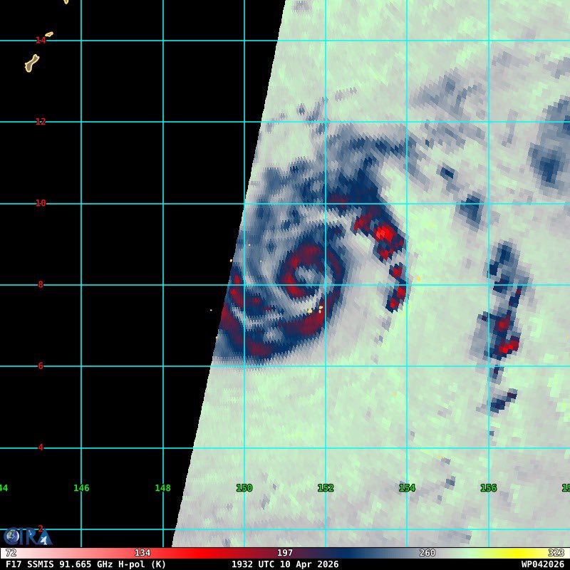
#Sinlaku (#04W) was upgraded to #typhoon status at 18Z, and it appears to be poised for rapid intensification. Microwave satellite imagery from about 1930Z suggests that an inner core has formed with a very small eye feature. This is bad news for #Guam.

Habol tayo ng misa. Need to thank the Lord for the blessing of life and for sparing me and my family from the calamities. Also, pray for those who are in the middle of the calamities. It is the least I can do for now. #sunday #typhoon

Something went wrong.
Something went wrong.
United States Trends
- 1. #euphoria N/A
- 2. #GoAvsGo N/A
- 3. #GoAvsGo N/A
- 4. Jarrett Allen N/A
- 5. BEST OF ME N/A
- 6. #mnwild N/A
- 7. Rudy N/A
- 8. #RHOA N/A
- 9. Cale Makar N/A
- 10. Wallstedt N/A
- 11. Quinn Hughes N/A
- 12. Raptors N/A
- 13. Edmond N/A
- 14. Jules N/A
- 15. Wally N/A
- 16. Lou Ann N/A
- 17. Habs N/A
- 18. Max Strus N/A
- 19. Pistons in 6 N/A
- 20. Montreal N/A