#wafbfirstalert search results

WAFB FIRST ALERT: U.S. Drought Monitor (USDM) Thursday Update Did Wednesday's rain take a bite out of the local drought? #WAFBFirstAlert

FIRST ALERT: Monday Evening QuickCast - highs in the 90°s thru Thursday - 'cool' front slowly pushed thru Louisiana on Friday - frontal rain totals will be a big disappointment ... but ... - a real "fall feel" arrives just in time for the upcoming weekend #WAFBFirstAlert
Baton Rouge Weekend ParadeCasts - looks good for Artemis (Friday 7:00 PM) - dodging raindrops for Mystique (Saturday 2:00 PM) - umbrellas and rain gear for Orion (Saturday 6:30 PM) - optimistic for a dry Mid City Gras (Sunday 1:00 PM) #WAFBFirstAlert

Friday Evening QuickCast - feeling like fall this weekend - breezy for both days, especially in the afternoons - mainly-dry cold front slides thru early Saturday - morning lows in the 40°s for Tuesday & Wednesday #WAFBFirstAlert
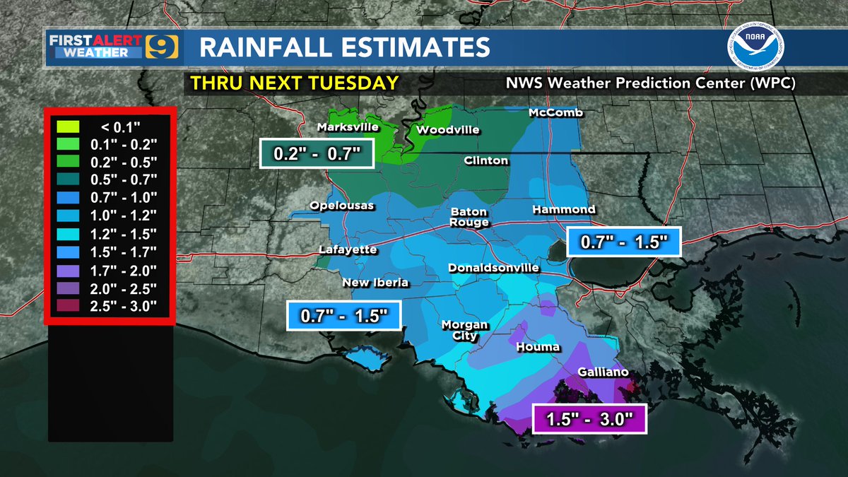
Tuesday Evening QuickCast - rain likely on Wednesday but not a drought-buster - 0.5" or less for most WAFB areas north of the I-10/12 corridor - daily totals could top 1.0" for many WAFB coastal communities #WAFBFirstAlert
Thursday Evening QuickCast - highs could reach the upper 80°s on Friday - early morning "dry" cold front on Saturday - cooler and sunshine for both weekend afternoons - dry weather persists through most of next week #WAFBFirstAlert
#WAFBFirstAlert: Thursday 9:50 AM Thin cirrus cloud deck creating this bright “solar halo” … as seen from SW EBR.

FIRST ALERT: Thursday Evening QuickCast - rains were even less than predicted ... drought rages on - weekend temps should be a joy ... but ... - gusty winds & low humidity on Saturday will mean an even greater wildfire threat #WAFBFirstAlert
Wednesday Morning ISS Fly-Over - skies should cooperate for a nice 6+ minute fly-by of the ISS from SW to NE ... passing almost directly overhead at about 6:21 AM. #WAFBFirstAlert

Wednesday Evening QuickCast - Wednesday rains of 0.5" to 1.5" for much of the WAFB region - good start but far from a drought-buster - mostly-dry cold front on Friday leads to a nice autumn weekend - unfortunately, mainly-dry thru the next 7 to 10 days #WAFBFirstAlert
Friday Evening QuickCast - Baton Rouge lows near 60° for Saturday AM ... upper 40°s to low 50°s for Sunday AM - weekend highs only reach the upper 70°s for many - RED FLAG WARNING / enhanced wildfire threat on Saturday due to dry conditions & gusty winds #WAFBFirstAlert
FIRST ALERT: Friday PM Update - hot, dry weekend ahead - regional Burn Ban continues, drought conditions could worse - 7-day outlook: 'cool' front expected Oct 5-6 ... less than 0.5" of rain #WAFBFirstAlert
FIRST ALERT: Tuesday Evening QuickCast - more 90°s as we await Friday's front - weekend high temps in the upper 70°s to low 80°s - unfortunately most of us get less than 1/4" of rain - no impact on the drought #WAFBFirstAlert
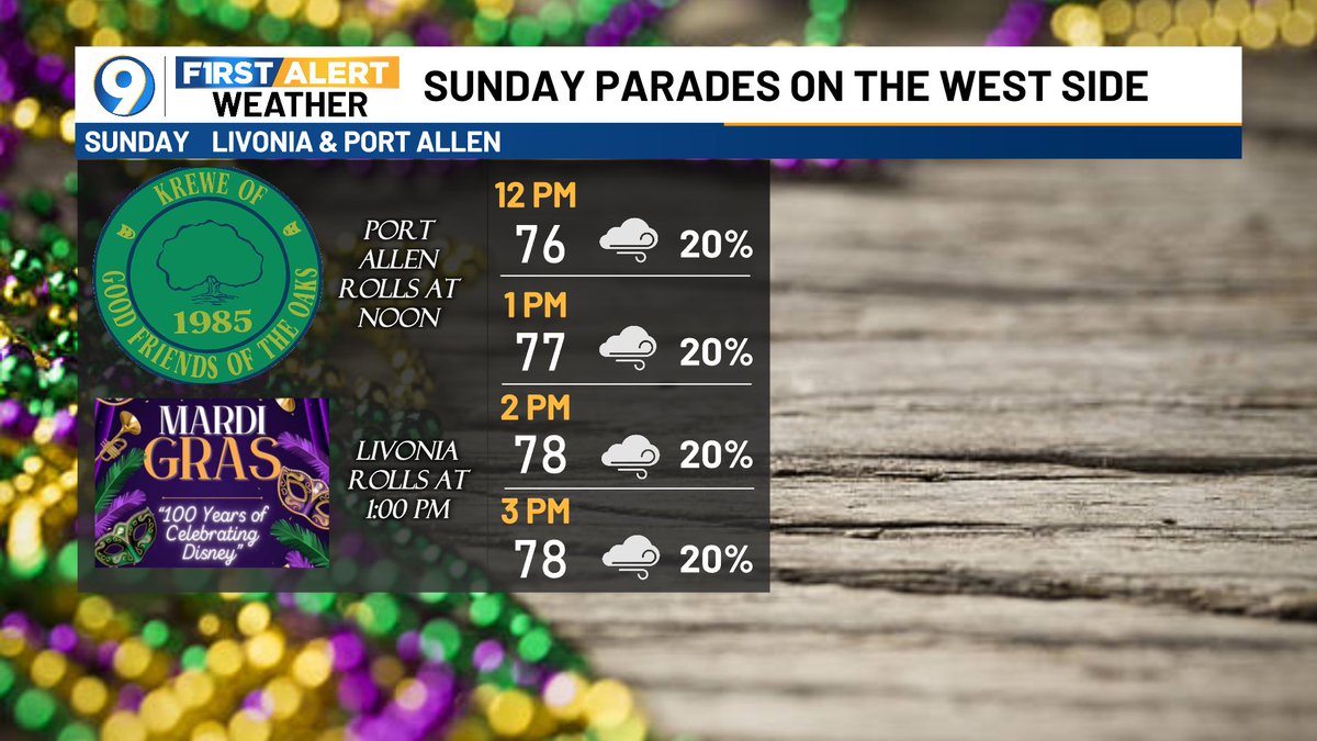
Sunday parades (Port Allen & Livonia) may have to dance around raindrops but active weather should hold-off until later in the day. Cool-ish but dry for Monday PM parades in Plaquemine & Shenandoah. A sunny FAT Tuesday with afternoon temps in the low 60°s. #WAFBFirstAlert


After a record warm summer and temps remaining above-normal for much of the past few weeks ... I've been frequently asked, "Are we finally done with those 90°s?" Just remember ... it's weather ... "Never say never." #WAFBFirstAlert

WAFB FIRST ALERT: Wednesday Evening QuickCast - 2 fronts push thru between Thursday & late Friday - no severe storms expected - some WAFB areas could go nearly rain-free - turning MUCH cooler: weekend highs only reach the upper 70°s for many WAFB communities #WAFBFirstAlert
WAFB FIRST ALERT: Thursday Update - east of the Atchafalaya Basin "shorted" on rains - real "autumn feel" comes this weekend ... but ... - elevated wildfire concern - local drought can't get much more critical for most WAFB communities #WAFBFirstAlert


Sunday parades (Port Allen & Livonia) may have to dance around raindrops but active weather should hold-off until later in the day. Cool-ish but dry for Monday PM parades in Plaquemine & Shenandoah. A sunny FAT Tuesday with afternoon temps in the low 60°s. #WAFBFirstAlert
#WAFBFirstAlert: Thursday 9:50 AM Thin cirrus cloud deck creating this bright “solar halo” … as seen from SW EBR.
Baton Rouge Weekend ParadeCasts - looks good for Artemis (Friday 7:00 PM) - dodging raindrops for Mystique (Saturday 2:00 PM) - umbrellas and rain gear for Orion (Saturday 6:30 PM) - optimistic for a dry Mid City Gras (Sunday 1:00 PM) #WAFBFirstAlert
Wednesday Morning ISS Fly-Over - skies should cooperate for a nice 6+ minute fly-by of the ISS from SW to NE ... passing almost directly overhead at about 6:21 AM. #WAFBFirstAlert
After a record warm summer and temps remaining above-normal for much of the past few weeks ... I've been frequently asked, "Are we finally done with those 90°s?" Just remember ... it's weather ... "Never say never." #WAFBFirstAlert
Friday Evening QuickCast - feeling like fall this weekend - breezy for both days, especially in the afternoons - mainly-dry cold front slides thru early Saturday - morning lows in the 40°s for Tuesday & Wednesday #WAFBFirstAlert
Thursday Evening QuickCast - highs could reach the upper 80°s on Friday - early morning "dry" cold front on Saturday - cooler and sunshine for both weekend afternoons - dry weather persists through most of next week #WAFBFirstAlert
WAFB FIRST ALERT: U.S. Drought Monitor (USDM) Thursday Update Did Wednesday's rain take a bite out of the local drought? #WAFBFirstAlert
Wednesday Evening QuickCast - Wednesday rains of 0.5" to 1.5" for much of the WAFB region - good start but far from a drought-buster - mostly-dry cold front on Friday leads to a nice autumn weekend - unfortunately, mainly-dry thru the next 7 to 10 days #WAFBFirstAlert
Tuesday Evening QuickCast - rain likely on Wednesday but not a drought-buster - 0.5" or less for most WAFB areas north of the I-10/12 corridor - daily totals could top 1.0" for many WAFB coastal communities #WAFBFirstAlert
Monday Evening QuickCast - dry Tuesday ... wet Wednesday - possibly 1" to 2" near/along the coast - early guidance suggests less than 1/2" for areas north of I-10/12 - add low-end rain chances in the forecast for Friday #WAFBFirstAlert
Friday Evening QuickCast - Baton Rouge lows near 60° for Saturday AM ... upper 40°s to low 50°s for Sunday AM - weekend highs only reach the upper 70°s for many - RED FLAG WARNING / enhanced wildfire threat on Saturday due to dry conditions & gusty winds #WAFBFirstAlert
FIRST ALERT: Thursday Evening QuickCast - rains were even less than predicted ... drought rages on - weekend temps should be a joy ... but ... - gusty winds & low humidity on Saturday will mean an even greater wildfire threat #WAFBFirstAlert
WAFB FIRST ALERT: Thursday Update - east of the Atchafalaya Basin "shorted" on rains - real "autumn feel" comes this weekend ... but ... - elevated wildfire concern - local drought can't get much more critical for most WAFB communities #WAFBFirstAlert
WAFB FIRST ALERT: Wednesday Evening QuickCast - 2 fronts push thru between Thursday & late Friday - no severe storms expected - some WAFB areas could go nearly rain-free - turning MUCH cooler: weekend highs only reach the upper 70°s for many WAFB communities #WAFBFirstAlert
FIRST ALERT: Tuesday Evening QuickCast - more 90°s as we await Friday's front - weekend high temps in the upper 70°s to low 80°s - unfortunately most of us get less than 1/4" of rain - no impact on the drought #WAFBFirstAlert
FIRST ALERT: Monday Evening QuickCast - highs in the 90°s thru Thursday - 'cool' front slowly pushed thru Louisiana on Friday - frontal rain totals will be a big disappointment ... but ... - a real "fall feel" arrives just in time for the upcoming weekend #WAFBFirstAlert
FIRST ALERT: Friday PM Update - hot, dry weekend ahead - regional Burn Ban continues, drought conditions could worse - 7-day outlook: 'cool' front expected Oct 5-6 ... less than 0.5" of rain #WAFBFirstAlert


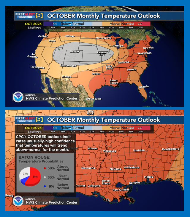
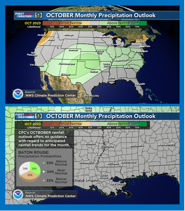
NWS/Climate Prediction Center October Outlooks: (1) Louisiana monthly temps likely to average above-normal again (2) no tendencies provided for monthly rainfall trends (3) no significant improvements in the drought situation -- at least in the short term #WAFBFirstAlert
Not a drought-buster ... but at least enough to ease some of the enviro-stress on the short term. Unfortunately, not only do we roll into another dry streak next week ... but we flirt with another round of near 100° days. Mother nature can be merciless ... #WAFBFirstAlert
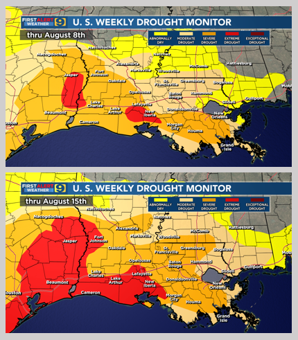
#WAFBFirstAlert: U.S. Drought Monitor (USDM) Update Drought intensifies over much of Louisiana ... in fact, a good argument could be made that the USDM is still behind 'reality.' Expect additional downgrades next week. Note: USDM maps only include data thru the previous Monday
WAFB FIRST ALERT: U.S. Drought Monitor (USDM) Thursday Update Did Wednesday's rain take a bite out of the local drought? #WAFBFirstAlert
Sunday parades (Port Allen & Livonia) may have to dance around raindrops but active weather should hold-off until later in the day. Cool-ish but dry for Monday PM parades in Plaquemine & Shenandoah. A sunny FAT Tuesday with afternoon temps in the low 60°s. #WAFBFirstAlert
Baton Rouge College Football Saturday Night ... Hot but less humid for the tailgating ... becoming almost comfortable thru the games. Back on the winning track for the Jaguar Nation and the Tiger Faithful! #WAFBFirstAlert

Wednesday Morning ISS Fly-Over - skies should cooperate for a nice 6+ minute fly-by of the ISS from SW to NE ... passing almost directly overhead at about 6:21 AM. #WAFBFirstAlert
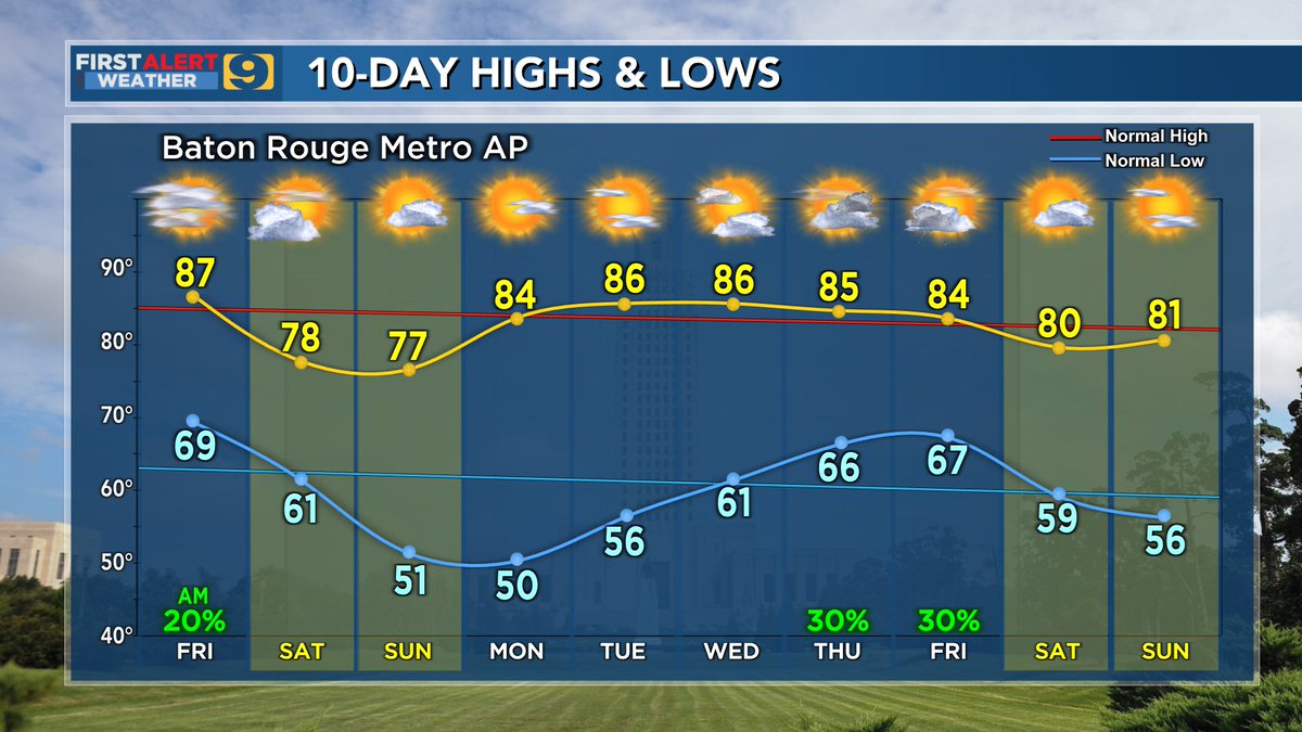
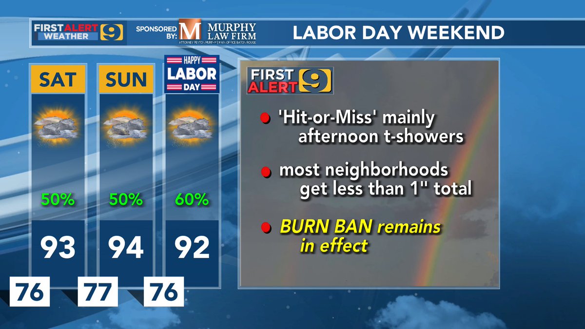
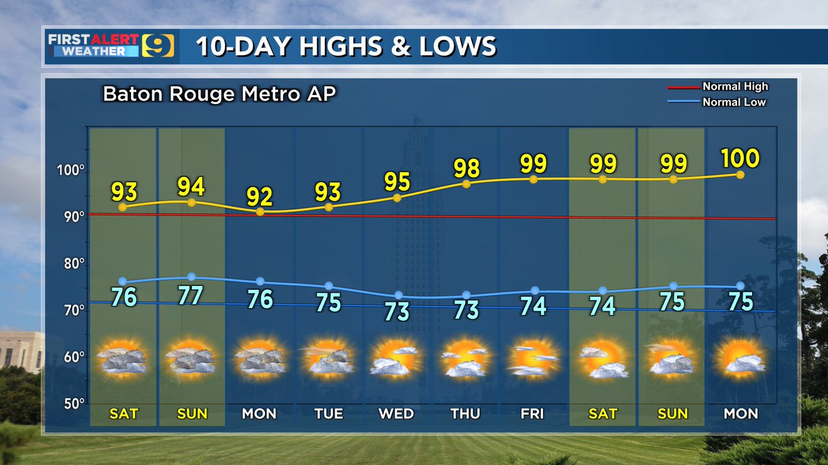
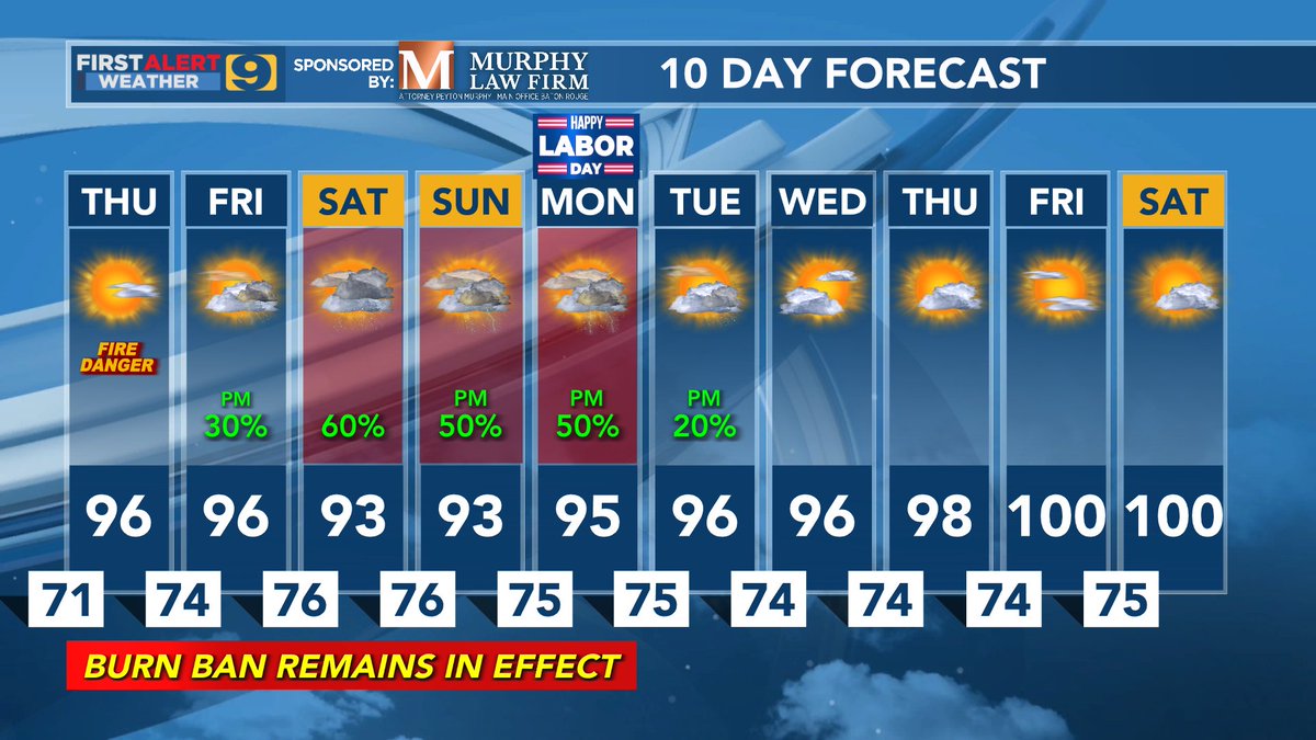
#WAFBFirstAlert: 10-Day Forecast - rain in the forecast ... but most WAFB neighborhoods will get less than 1" of rainfall over the 10-day run - not a single high temp below normal ... and a return of temps near 100° at the end of the run?
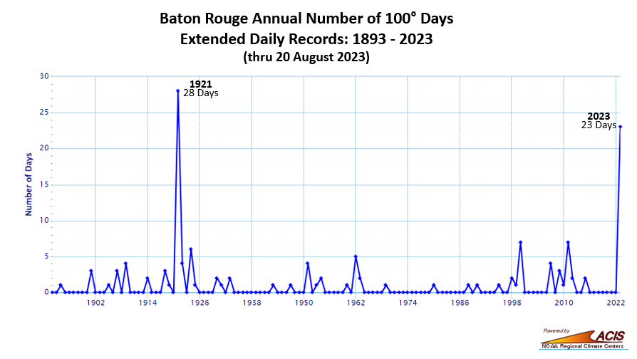
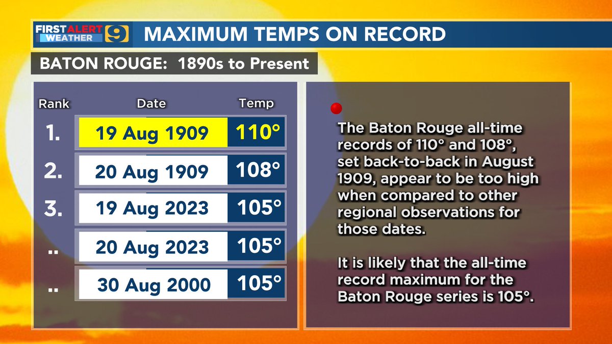
Compared to all years prior to 2023, that 1921 'spike' seems dubious. But it is less of an issue now ... With a forecast that calls for many (most?) of the remaining days in August to reach 100° or more, 2023 will be the new King-of-the-Hill for 100° days. #WAFBFirstAlert
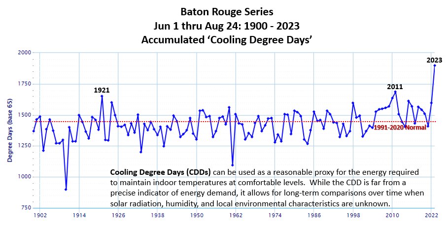
Another way to see just how off-the-charts the 2023 summer has been in terms of extraordinary temperatures. Baton Rouge Accumulated CDDs thru August 24 are running better than 130% of normal. That's sure to translate into higher energy demands. #WAFBFirstAlert
Baton Rouge Weekend ParadeCasts - looks good for Artemis (Friday 7:00 PM) - dodging raindrops for Mystique (Saturday 2:00 PM) - umbrellas and rain gear for Orion (Saturday 6:30 PM) - optimistic for a dry Mid City Gras (Sunday 1:00 PM) #WAFBFirstAlert
After a record warm summer and temps remaining above-normal for much of the past few weeks ... I've been frequently asked, "Are we finally done with those 90°s?" Just remember ... it's weather ... "Never say never." #WAFBFirstAlert
#WAFBFirstAlert: Monday PM Relentless heat ... and remains so for the foreseeable future. The 2023 summer continues on it's record shattering pace. The 10-Day Forecast include a string of dates with forecasted max temps (in yellow) that will tie or break each daily record.

Heading into the final days of August ... here's a quick look at the season tracks thus far and where 2023 currently stands compared to "climatology." #WAFBFirstAlert
The good news: - a few days below 95° and lows in the upper 60°s for several days The bad news: - outlook for a good soaking is bleak: current guidance suggests that most of the area will by lucky to get 1/2" of rain over the next 7 to 10 days #WAFBFirstAlert

More indicators of the relentless heat of 2023 ... as of Friday evening: 28* - will be up to 30 by the end of the weekend and could go even higher over the next couple of weeks 8** - will be 10 on Sunday afternoon, and could go to 11 on Monday #WAFBFirstAlert
#WAFBFirstAlert: Thursday 9:50 AM Thin cirrus cloud deck creating this bright “solar halo” … as seen from SW EBR.
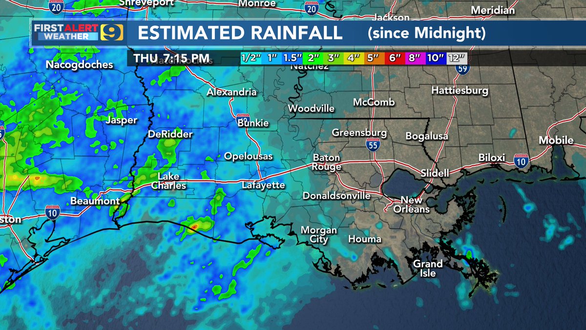
#WAFBFirstAlert: Tuesday Afternoon A few will get rain this afternoon & early evening as the 'cool' front slides across the WAFB region. The next 'best chance' for rain is early next week. However, the latest model runs are less promising than earlier runs. Stay tuned ...

WAFB FIRST ALERT: Thursday Update - east of the Atchafalaya Basin "shorted" on rains - real "autumn feel" comes this weekend ... but ... - elevated wildfire concern - local drought can't get much more critical for most WAFB communities #WAFBFirstAlert
Something went wrong.
Something went wrong.
United States Trends
- 1. Good Wednesday N/A
- 2. Colbert N/A
- 3. Hump Day N/A
- 4. Tolkien N/A
- 5. LOTR N/A
- 6. Nikita N/A
- 7. Lord of the Rings N/A
- 8. Sora N/A
- 9. #OpeningDay N/A
- 10. Cozy Sunday N/A
- 11. #RepBX N/A
- 12. #Daredevil N/A
- 13. Whale - Buy N/A
- 14. Smart Money - Buy N/A
- 15. QUICK TRADE N/A
- 16. TOP CALL N/A
- 17. #zzzero N/A
- 18. Flynn N/A
- 19. Fast Transactions N/A
- 20. Democrat Emily Gregory N/A